General Information
Nahiya (Subdistrict)
Cindires
Also Known As
Joban, Jobanli, Çobana, جوبان, جوبانلي, چوبانلي, جوبانه راجو
Photos
Basic Information about Çobana - Cindires
Source: Tirej Afrin
Etymology: Çoban: Meaning the shepherd and it is a word of Turkish origin
Foundation Date/Period: Approximately 100 years ago
Hills: Çiyayê Xastiyan
Summaries
I. Summary from TirejAfrin Site (English) of Çobana - Cindires
Source: https://www.tirejafrin.com/site/kura%20afrin%20Cindires%20-%20cobana.htm
It is stated in the book جبل الكرد (عفرين) دراسة جغرافية Çiyayê Kurmênc (Efrîn): A Geographical Study by د. محمد عبدو علي Dr. Mihemed Ebdo Elî: Obana, Çobanlî, Coban. 464 inhabitants. 12 km. 464 meters elevation.
Çoban: Meaning "the shepherd" and it is a word of Turkish origin.
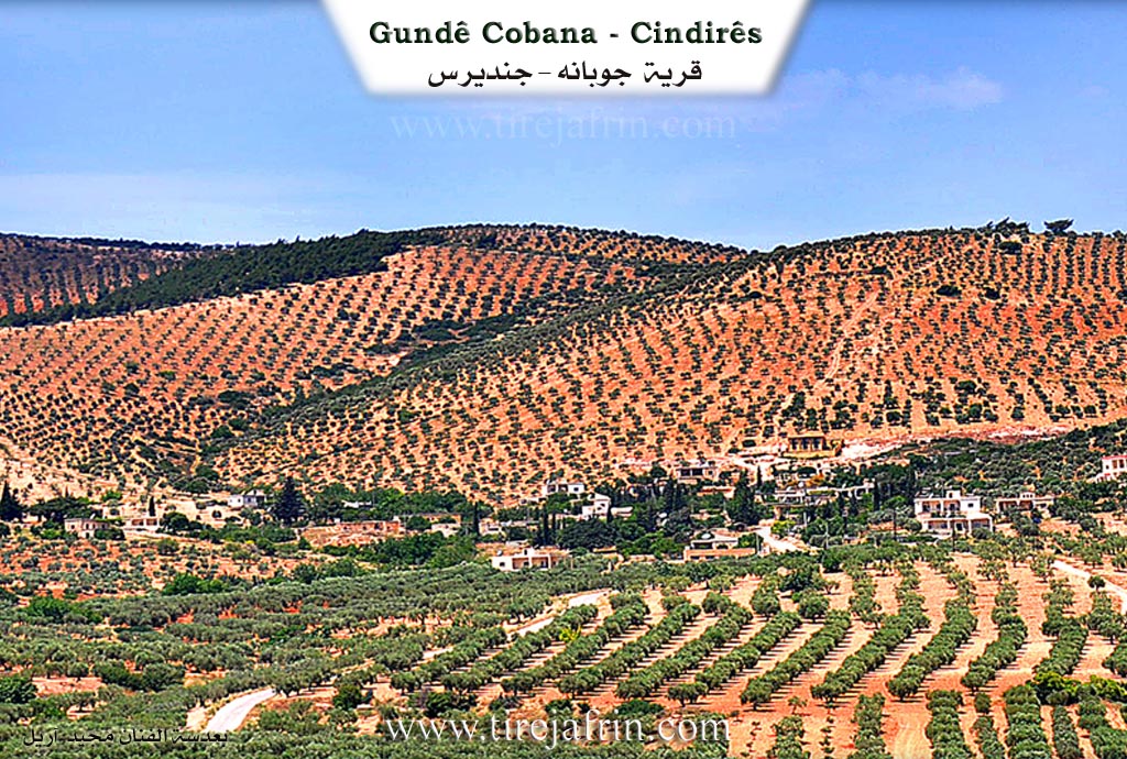
It is a small village located on the southern slopes of Çiyayê Xastiyan west of the village of Gorda.
It is stated in the book عفرين .... نهرها وروابيها الخضراء Efrîn... Her River and Her Green Hills by the writer عبدالرحمن محمد Ebdulrehman Mihemed from the village of Qetme: Çobanlî is a village in Çiyayê Kurmênc, affiliated with the Cindirês district, Efrîn region, Heleb governorate. It is a small village located at the end of the southeastern edge of the middle part of the mentioned mountain block, at the bottom of the valley, and between three high mountain heights to the north, west, and east, except for the southern side which is open to the Cindirês plain.
It is bordered to the north by a high mountain chain planted with olive and forest trees and the villages of Hec Hesenê, Tatara, and Rûta; to the south by a waterway descending towards the south heading to the plain of Koran, Zindîkan, Cindirês, and the mentioned villages; to the west by a high mountain chain planted with olive trees and the village of Kefer Sefrê; and to the east by mountain heights planted with olive and forest trees and the villages of Miska Jorîn, Xalta Şerqî, and Xalta Xerbî.
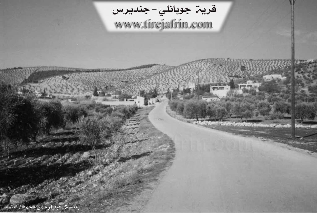
The number of its houses reaches about 25 houses, and its age is about 100 years, indicated by the presence of an old well in the center of the village used by the residents for drinking. Its old houses are stone and mud with flat wooden roofs, and the modern ones are cement, spread on both sides of the public road.
An electricity network is available, as well as drinking water from the well dug in the north of the village by the state and from the well of Koran. It has a primary school and an asphalt road connecting the village with the district center and neighboring villages. Most of its inhabitants work in rain fed agriculture (olives, vines, grains), alongside raising sheep and goats. It follows the village of Koran administratively.
Village Mukhtar: Mihemed Ehmed Xurşîd
Preparation and execution:
Manager of Tirej Efrîn site: Ebdulrehman Hacî Osman
20/12/2013
Sources
Book: جبل الكرد (عفرين) دراسة جغرافية Çiyayê Kurmênc (Efrîn): A Geographical Study by د. محمد عبدو علي Dr. Mihemed Ebdo Elî.
Book: عفرين .... نهرها وروابيها الخضراء Efrîn... Her River and Her Green Hills by عبدالرحمن محمد Ebdulrehman Mihemed from the village of Qetme.
I. Summary from TirejAfrin Site (English) of Çobana
According to the book 'جبل الكرد' 'Mountain of the Kurds' - A Geographical Study by Dr. Mohammed Abdo Ali (الدكتور محمد عبدو علي):
Çobana - Cindires (چوبانلي), Jobanli (جوبانلي), Joban (جوبان) /464N - 12km - 464m/:
- Çoban (چوبان): means "the shepherd" and it is a word of Turkish origin.
- A small village located on the southern slopes of Mount Hashtiya (جبل حشتيا) west of Gordan village (قرية گوردان).
According to the book: Afrin.... Its River and Green Hills by writer Abdul Rahman Mohammed (عبدالرحمن محمد) from Qatmeh village (قرية قطمه):
Jobanli (جوبانلي): A village in the Kurdish Mountain (جبل الكرد), belonging to Cindirês subdistrict (ناحية جندیرس), Afrin (منطقة عفرين), Aleppo Governorate (محافظة حلب).
It is a small village located at the end of the southeastern tip of the middle part of the aforementioned mountain mass and at the bottom of the valley and between three high mountainous heights to the north, west, and east, except for the southern side which is open to the Cindirês plain (سهل جندیرس).
To the north, there is a high mountainous chain planted with olive and forest trees and Haj Hasanli village (قرية حاج حسنلي) and Tataranli (تاتارانلي) and Rutanli (روطانلي). To the south, there is a stream descending south towards the plain of Koran (كوران) and Zindkan (زندكان) and Cindirês (جندیرس) and the mentioned villages. To the west, there is a high mountainous chain planted with olive trees and Kefar Safra village (قرية كفر صفرة). To the east, there are mountainous heights planted with olive and forest trees and Miske Foqani village (قرية مسكة فوقاني) and Khaltan East and West (خلطان شرقي وغربي). It has about 25 houses and its age is about 100 years, as evidenced by the existence of an old well in the center of the village used by the locals for drinking. Its old houses are stone and clay with flat wooden roofs, and the modern ones are concrete spread on both sides of the public road. It has an electricity network and drinking water from the well dug in the north of the village by the state and from the Koran well (بئر كوران). It has an elementary school and a paved road connects the village with the subdistrict center and neighboring villages. Most of its residents work in rainfed agriculture (olives, vines, grains), in addition to raising sheep and goats. It administratively belongs to Koran village (قرية كوران).
Village Headman: Mohammed Ahmed Khourshid (محمد أحمد خورشيد)
Possible Village Name Meaning of Çobana - Cindires
"Çoban" means "the shepherd" and is a word of Turkish origin.
Source: TirejAfrin Site