General Information
Nahiya (Subdistrict)
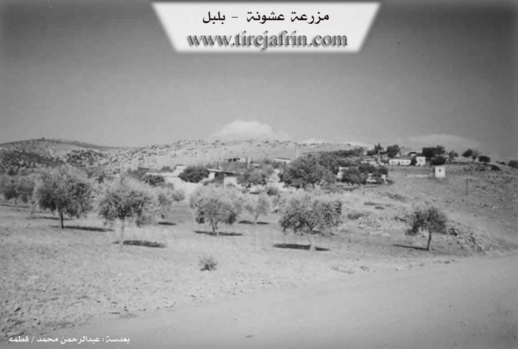
Bilbilê
Also Known As
'Eşûnê, Ashani, Ashanli, Ashuna, Ešûnê, عشانلي، عشاني, عشونة /عشاني, عشونه

Photos
Basic Information about Eşûnê
Source: Tirej Afrin
Etymology: It is a female proper name derived from the name of the first woman who inhabited the village; she originated from the village of Şêx on Çiyayê Hawar and was the sister of Şêx Îhmo, the founder of the village of Şêx
Foundation Date/Period: Approximately 200 years ago
Hills: Çiyayê Hawar
Wells: Çetal Quyu
Other Landmarks: Geliyê Cerqa, Seda Eşonê, Ziftik
Summaries
I. Summary from TirejAfrin Site (English) of Eşûnê
Source: https://www.tirejafrin.com/site/kura%20afrin%20%20%20bilbile%20-%20eshona.htm
The book جبل الكرد (عفرين) دراسة جغرافية Çiyayê Kurmênc (Efrîn): A Geographical Study states: Eşonê Eşanlî Eşanî / 619 inhabitants - 160 hectares - 21 km - 660 m altitude.
Eşonê: It is a female proper name derived from the name of the first woman who inhabited the village. Her origin was from the village of Şêx (Gu. Şx) on Çiyayê Hawar, and she was the sister of Şêx Îhmo, the founder of the village of Şêx.
It is a small village located on the slope of a height, from which torrents descend towards Geliyê Cerqa (Cerqa valley) which passes to its west. A storage dam, Seda Eşonê (Eşonê dam), was built next to it but was not utilized due to a flaw in the geological study; the ground layers absorbed a massive amount of water within a few hours.
The book عفرين .... نهرها وروابيها الخضراء Efrîn... Her River and Her Green Hills states: Eşonê is a village in Çiyayê Kurmênc following the sub-district of Bilbil, area of Efrîn, governorate of Heleb. It is a small village situated on the southwestern slope of a limestone height, in the middle of the northern section of the mentioned mountain. Torrents descend from it towards Geliyê Cerqa. Its soil is alluvial clay. It is located to the southwest of the town of Bilbil at a distance of 21 km.
It is bordered to the north, at a distance of 500m, by the village of Saghir Obasî; to the south by a valley, a mountain chain, and the farm of Ziftik; to the west by a valley, the Seda Eşonê (Eşonê dam), which collapsed due to the lack of water in it, the village of Dîk Obasî on the highest elevation, and Çetal Quyu; and to the east by a high mountain chain planted with forest trees and the village of Xelîlak Uşaxî.
The number of its houses reaches about 35, and its age is approximately 200 years according to what one of the elderly persons mentioned. Its old houses are made of stone and mud with flat wooden roofs, while the modern ones are cement and are expanding towards the northeast. A electricity network is available, as well as a school shared with Saghir, and it contains a modern olive press. The village drinks from cisterns in which rainwater is collected. Most of its inhabitants work in the cultivation of olives, grains, and vines via rain-fed agriculture on an area of 160 hectares, alongside raising sheep and goats.
The road from it to the town of Bilbil is paved, while the road from the village to the main road is dirt and unpaved. The farm of Ziftik is attached to it.
Village Mukhtar: Nûrî Bilal Mihemed.
Sources of Information:
- Book: جبل الكرد (عفرين) دراسة جغرافية Çiyayê Kurmênc (Efrîn): A Geographical Study by د. محمد عبدو علي Dr. Mihemed Ebdo Elî.
- Book: عفرين .... نهرها وروابيها الخضراء Efrîn... Her River and Her Green Hills by عبدالرحمن محمد Ebdulrehman Mihemed from the village of Qetme.
- Studies of Navenda Tirej Soft / Ebdulrehman Hacî Osman.
- Some residents of the villages.
Preparation and Execution: Manager of Tirej Efrîn site: Ebdulrehman Hacî Osman 20/12/2013
Possible Village Name Meaning of Eşûnê
A feminine proper name derived from Ashuna, the first woman who lived in the village. She was from Q. Sheikh village and was the sister of Sheikh Ihmo, founder of "Sheikh" village.
Source: TirejAfrin Site