General Information
Nahiya (Subdistrict)
Efrîn
Also Known As
زوق الكبير, Gu. Mezin, Gu.Mezin, الكبيرة, بيوك أوبه
Families, Clans, etc.
Al Hesen Efendî

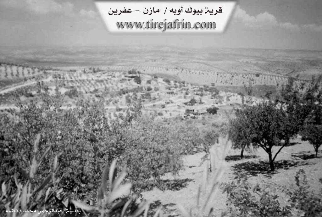
Photos
Basic Information about Gundê Mezin - above Ma'rata
Source: Tirej Afrin
Etymology: The name means the big village (gund + mezin). Both the names before and after Arabization are translations of the old folk name.
Foundation Date/Period: 300 years
Hills: Çiyayê Heştiyan
Wells: Bîra Romanî
Summaries
I. Summary from TirejAfrin Site (English) of Gundê Mezin - above Ma'rata
Source: https://www.tirejafrin.com/site/kura%20afrin%20markaz-Gu.%20Mezin.htm
The following text states in the book جبل الكرد (عفرين) دراسة جغرافية Çiyayê Kurmênc (Efrîn): A Geographical Study by د. محمد عبدو علي Dr. Mihemed Ebdo Elî: /305m altitude, 8km distance/: Mezin, Biyûk Oba, Al-Kabîra /790 inhabitants, 9km, 585m/:
The name means "the big village" (gund + mezin). It was the headquarters of the Aghas of the Al Hesen Efendî family in the eighteenth century. It was one of the large and important villages at that time, which is why it was called the big one. Both the names before and after Arabization are translations of the old folk name.
The village is located on a high peak in Çiyayê Heştiyan. Most of its inhabitants left due to the lack of fertility of its lands, so it turned into a small, marginalized village.
The following text states in the book عفرين .... نهرها وروابيها الخضراء Efrîn... Her River and Her Green Hills by the writer عبدالرحمن محمد Ebdulrehman Mihemed from the village of Qetme: Biyûk Oba / Gundê Mezin:
It is a village in Çiyayê Kurmênc, belonging to the villages of the Efrîn center and district, Heleb governorate. It is a small village on a mountain slope, with a deep valley in front of it from the western and southern sides.
It is bordered to the north by a mountain range and valleys planted with olive trees and vines, and the village of Dargirê Mezin. To the south, it is bordered by a slope, a valley, a mountain range, and the village of Kefer Delê Jêrîn. To the east, it is bordered by a slope, a plain, a fertile mountain range planted with olive trees, and the villages of Maratê and Xelner. To the west, a deep valley separates the village of Tel Xazî and Biyûk Oba.
The number of its houses reaches about 25 houses, and its age is 300 years. An electricity network, a paved dirt road, and a primary school are available in it. The people of the village drink from the very old ancient Bîra Romanî (Roman well) from the western side of the village at the bottom of the valley. Its houses are made of stone and wood, and the modern ones are made of reinforced concrete and stone. The residents work in the cultivation of olives and vines and the raising of livestock.
Among the holders of higher degrees in the village: Ciwan Bekir bin Mihemed Şekîb (PhD in Medical Devices, University of Refrigeration, Ukraine).
Village Mukhtar: Mihemed Êso.
Preparation and execution:
Manager of the Tirej Efrîn site: Ebdulrehman Hacî Osman
20/12/2013
Sources
Book: جبل الكرد (عفرين) دراسة جغرافية Çiyayê Kurmênc (Efrîn): A Geographical Study by د. محمد عبدو علي Dr. Mihemed Ebdo Elî.
Book: عفرين .... نهرها وروابيها الخضراء Efrîn... Her River and Her Green Hills by عبدالرحمن محمد Ebdulrehman Mihemed from the village of Qetme.
I. Summary from TirejAfrin Site (English) of Mezin
Villages of Central District / City of Afrin / Efrîn
بيوك أوبة / Gu. Mezin
===
According to the book 'جبل الكرد' 'Mountain of the Kurds' (Afrin) Geographic Study by Dr. Mohammed Abdo Ali:
/305m - 8km /:
Mezin, Büyük Oba, Al-Kabirah /790 inhabitants - 9km - 585m/:
- The name means "the big village", and it was the headquarters of Al Hassan Afandi family aghas in the eighteenth century, and it was then one of the large and important villages and therefore was called the big one. The two names before and after Arabization are a translation of the old popular name.
- Located on a high summit in Mount Hashtian. Most of its inhabitants left due to the low fertility of its lands, so it turned into a small, neglected village.
And according to the book: Afrin.... Its River and Green Hills by writer Abdul Rahman Mohammed from Qatmeh village
Büyük Oba - Kandah Mazan: A village in Mount of the Kurds, belonging to central villages and Afrin region, Aleppo Governorate.
It is a small village on a mountain slope with a deep valley in front of it from the western and southern sides. It is bounded to the north by a mountain chain and valleys cultivated with olive and vine trees and Dar Kir Kabir village, to the south by a slope and valley and mountain chain and Kafr Dali Tahtani village, to the east by a slope and plain and fertile mountain chain cultivated with olive trees and Maarateh village and Khalanir, and to the west by a deep valley separating between Tell Ghazi village and Büyük Oba. The number of its houses is about 25 houses and its age is 300 years. There is an electricity network and a paved dirt road and an elementary school. The village people drink from the very ancient Roman archaeological well from the western side of the village at the bottom of the valley. Its houses are stone and wood and the modern ones are of reinforced concrete and stone. The residents work in cultivating olives and vines and raising livestock.
Among the holders of higher degrees in the village: Jwan Bakr son of Mohammed Shakib / doctorate in medical devices / University of Tabriz / Ukraine
Village Mukhtar: Mohammed Aisso
Preparation and implementation: Tirij Afrin website director: Abdul Rahman Haji Othman
20 / 12 / 2013
Foundation/Origin Information of Gundê Mezin - above Ma'rata
It was the headquarters of Al Hassan Afandi family aghas in the eighteenth century.
Source: TirejAfrin Site
Possible Village Name Meaning of Gundê Mezin - above Ma'rata
The name means 'the big village' because it was one of the large and important villages in the eighteenth century.
Source: TirejAfrin Site
V. Links
- Tirej Afrin:
https://www.tirejafrin.com/site/kura%20afrin%20markaz-Gu.%20Mezin.htm - Jawlat:
https://www.youtube.com/watch?v=X2ZOtfjjN6k - drone video:
https://www.youtube.com/watch?v=wtfwWmyY42E - Video:
https://www.youtube.com/watch?v=J-KGqCRw3p0 - Link:
https://www.youtube.com/watch?v=L0kc_DFSlS4 - Link:
https://www.youtube.com/watch?v=IvD7IYqC3SM