General Information
Nahiya (Subdistrict)
Efrîn
Also Known As
Keferbetrê, كفر بطرة
Families, Clans, etc.
Xubarî, Şêxo

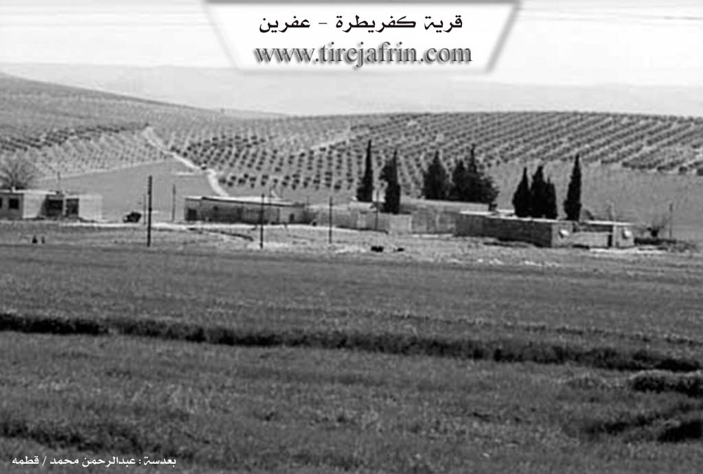
Photos
Basic Information about Keferbetrê
Source: Tirej Afrin
Etymology: Compound of Kefer + Betr. Likely Aramaic or Syriac. Al-Asadi suggests it means Village of the Farrier (Gundê Bîtar). Father Shalhat suggests Betr is Greek for The Rock (Petra)
Foundation Date/Period: 150 years
Hills: Qerac Reş, Ikaniya
Other Landmarks: Wadî El-Betîna, Wadî Efrîn, Riya Cindirês-Efrîn
Summaries
I. Summary from TirejAfrin Site (English) of Keferbetrê
Source: https://www.tirejafrin.com/site/kura%20afrin%20markaz-%20kefepetre.htm
According to the book جبل الكرد (عفرين) دراسة جغرافية Çiyayê Kurmênc (Efrîn): A Geographical Study by د. محمد عبدو علي Dr. Mihemed Ebdo Elî:
Keferbetr / 282 inhabitants, 327 hectares, 7 km, 295 m /.
It is believed that the name is a compound of Kefer + Betr. We have not found a definitive meaning for this name, although it leans towards Aramaic or Syriac names. El-Esedî stated regarding the name that it is from Aramaic meaning "Village of the Farrier", and it is not unlikely that Betr is Greek meaning "The Rock" (Petra), as Father Şelhet believes.
It is a small village consisting of several houses. It is located on the southern slope of Mount Qerac Reş or Ikaniya (Forty Springs). There are indications of ancient habitation evidenced by the presence of sites with soil used for habitation on the slopes located to its south. It is one of the villages of the Xubarî family, and the Kurdish writer, linguist, and journalist Dr. Ebdulmecîd Şêxo resides there.
According to the book عفرين .... نهرها وروابيها الخضراء Efrîn... Her River and Her Green Hills by the writer عبدالرحمن محمد Ebdulrehman Mihemed from the village of Qetme:
Keferbetr is a village in Çiyayê Kurmênc, administratively belonging to the Central Subdistrict of the Efrîn region, Heleb governorate. It is a very small village located on the southern slope of Mount Qerac Reş (Black Garage) to the southeast of Çiyayê Kurmênc. A stream cuts through it from the northwest to the southeast, feeding into Wadî El-Betîna which heads toward Wadî Efrîn in the east. It is 7 km away from the city of Efrîn toward the southwest.
It is bordered to the north by a wide plain, the Riya Cindirês-Efrîn (Cindirês-Efrîn road) planted with olive trees and grapevines, and the village of Keferdelê Jêrîn. To the south, it is bordered by an agriculturally fertile plain and the villages of Telif and Kewkebel. To the west, a wide and fertile plain and the Endêriyê farm. To the east, a wide agricultural plain, the village of Betîtê, the Hesûn farm, and Şêx Ebdulhenan.
The number of its houses is small, approximately seven houses, and its age is 150 years. Its old houses are made of stone and mud with wooden ceilings, while the modern ones are of stone and reinforced concrete. An electricity network is available, as well as a paved road up to the center of the village and a primary school. Residents drink water from artesian wells and pools. Its inhabitants work in the cultivation of grains, vegetables, and olives, and they raise sheep and goats. There are two modern presses in the village on the sides of the Riya Efrîn-Cindirês (Efrîn-Cindirês road), and it is situated in an agriculturally fertile plain.
Sources:
- Book: جبل الكرد (عفرين) دراسة جغرافية Çiyayê Kurmênc (Efrîn): A Geographical Study by د. محمد عبدو علي Dr. Mihemed Ebdo Elî.
- Book: عفرين .... نهرها وروابيها الخضراء Efrîn... Her River and Her Green Hills by عبدالرحمن محمد Ebdulrehman Mihemed from the village of Qetme.
Preparation and execution:
- Manager of Navenda Tirej Efrîn: Ebdulrehman Hacî Osman
- 20 12 2013
Foundation/Origin Information of Keferbetrê
It is among the Al-Ghabari family villages.
Source: TirejAfrin Site
Possible Village Name Meaning of Keferbetrê
The meaning is undetermined. It could be from Aramaic for "village of the veterinarian" or Greek for "rock".
Source: TirejAfrin Site