General Information
Nahiya (Subdistrict)
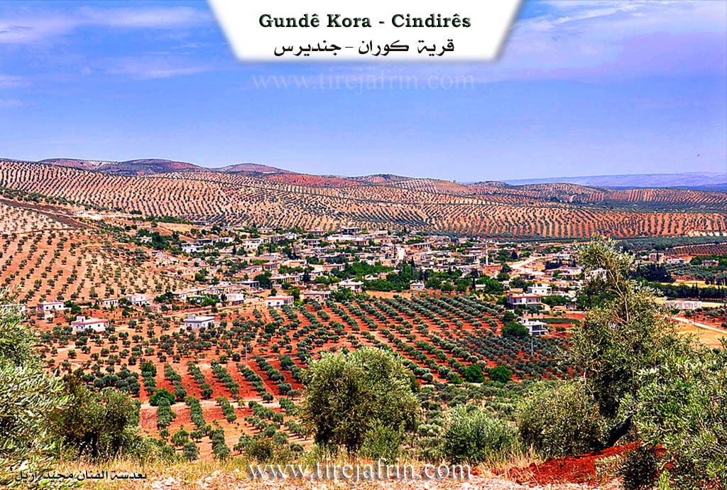
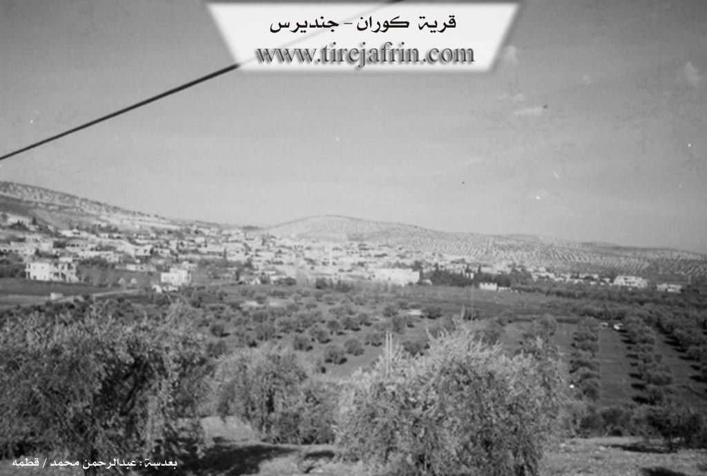
Cindires
Also Known As
Kora / Koran / Kore / Kouran, كوران جنديريس
Families, Clans, etc.
Elûş, Hac Birîm, Hac Mecîd, Kedûr, Xurşîd, Çawîş

Photos
Basic Information about Kora
Source: Tirej Afrin
Etymology: Derived from its low-lying location. It is also the name of a Kurdish tribe in Kirmaşan in Eastern Kurdistan and near Qers.
Foundation Date/Period: Approximately 500 years ago
Hills: Çiyayê Qaziqlî, Çiyayê Domûq
Wells: Bîra Romanî
Summaries
I. Summary from TirejAfrin Site (English) of Kora
Source: https://www.tirejafrin.com/site/kura%20afrin%20Cindires%20-%20Kora.htm
It is stated in the book جبل الكرد (عفرين) دراسة جغرافية Çiyayê Kurmênc (Efrîn): A Geographical Study by د. محمد عبدو علي Dr. Mihemed Ebdo Elî: Kora, Koran /1861 inhabitants - 315 hectares - 6km - 410m altitude/:
Kora: The village derived its name from its low-lying location. It is also the name of a Kurdish tribe in Kirmaşan in Eastern Kurdistan /Zekî, Vol 1, p. 430/. There is a tribe by the same name around Qers /Lerx, p. 61/.
It is a large village located at the end of the southeastern slope of Çiyayê Qaziqlî. It contains archaeological remains in the form of walls, columns, foundations, and an old water well.
It is stated in the book عفرين .... نهرها وروابيها الخضراء Efrîn... Her River and Her Green Hills by the writer عبدالرحمن محمد Ebdulrehman Mihemed from the village of Qetme:
Koran: A village in Çiyayê Kurmênc, administratively belonging to the Cindirês subdistrict, Efrîn region, Heleb governorate. It is a large village located at the end of the southeastern edge of Çiyayê Domûq and the beginning of the Cindirês plain, which possesses fertile alluvial soil and abundant groundwater. It is located 6km north of the town of Cindirês. The construction of the area is ancient, evidenced by archaeological remains represented by walls, columns, and foundations distributed in the village, and a well from the Roman era.
It is bordered to the north by mountainous heights planted with olive trees and the villages of Çobana and Tatara; to the south by the agriculturally fertile Cindirês plain planted with olive trees and pomegranate orchards, and the villages of Zindakan and Yalanqoz; to the west by an agriculturally fertile plain planted with olive trees and the village of Kefer Sefrê at a distance of 1km; and to the east by a valley and mountainous height planted with olive trees and the villages of Miskê Jêrîn, Fofana, and Burc Kemoş.
The number of its houses reaches 160, and its age is approximately 500 years. Its traditional houses are made of stone and mud with flat wooden roofs, while the modern ones are cement and have expanded towards the west, north, and east, avoiding agricultural lands. Some modern villas exist there. It has an electricity network and a water network supplied by local artesian wells via a state-owned water network or from the old Bîra Romanî (Roman well). The village contains a primary school and a mosque in the center of the village, as well as a telephone network from the Cindirês center. It has five modern presses for pressing olives.
The road from the village to the subdistrict center and neighboring villages is paved. Most of its residents work in olive cultivation, with a small amount of grains and legumes on an area of 299 hectares. Irrigated agriculture from artesian wells covers 16 hectares, producing summer vegetables, cotton, sugar beets, pomegranates, apples, and apricots, alongside the raising of sheep and goats. The village is considered famous for olive cultivation since ancient times due to the abundance of olive trees and both old and modern presses. It is a beautiful village in terms of location and the buildings scattered on both sides of the road. The farm of Çobana follows it administratively.
Among the families present are: Xurşîd, Kedûr (among them Dr. Mihemed Kedro / Dentist), Hac Mecîd, Hac Birîm, Çawîş, and Elûş.
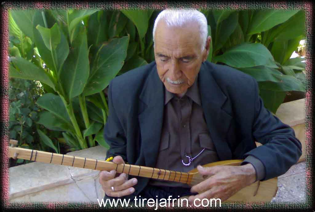
The village Mukhtar is Mr. Mihemed Xurşîd. Among the artistic personalities are the late Adîk Ebdulrehman Ehmed, the plastic artist Farûq Mihemed, and the buzuq player Cihad.
Sources:
- Book: جبل الكرد (عفرين) دراسة جغرافية Çiyayê Kurmênc (Efrîn): A Geographical Study by د. محمد عبدو علي Dr. Mihemed Ebdo Elî.
- Book: عفرين .... نهرها وروابيها الخضراء Efrîn... Her River and Her Green Hills by عبدالرحمن محمد Ebdulrehman Mihemed from the village of Qetme.
Preparation and Execution:
- Manager of Tirej Efrîn site: Ebdulrehman Hacî Osman
- 20/12/2013
Foundation/Origin Information of Kora
Construction is ancient as evidenced by archaeological remains from the Roman era.
Source: TirejAfrin Site
Possible Village Name Meaning of Kora
The village derived its name from its low location. It is also the name of a Kurdish tribe in Kermanshah.
Source: TirejAfrin Site
V. Links
- Tirej Afrin:
https://www.tirejafrin.com/site/kura%20afrin%20Cindires%20-%20Kora.htm - Ax û Welat:
https://www.youtube.com/watch?v=hiTBBtVq11E - Jawlat:
https://www.youtube.com/watch?v=rBHM0hUJ0gw - Drone video:
https://www.youtube.com/watch?v=C0_yEKPMLso - Video:
https://www.youtube.com/watch?v=3d73RLxApOU - Link:
https://www.youtube.com/watch?v=gaJpf_Ls-EE - Link:
https://www.youtube.com/watch?v=fYEgsG7TqC4