General Information
Nahiya (Subdistrict)
Efrîn
Also Known As
Me'riskê, معرسة الخطيب, معرسكه

Photos
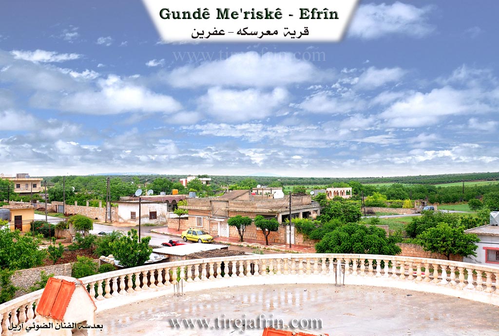
Basic Information about Me'riskê
Source: Tirej Afrin
Etymology: Me'ris is a Kurdish word meaning the strong and frightening man, implying someone with supernatural strength, or crushing something, or a press for grapes or olives
Foundation Date/Period: 1924
Hills: Çiyayê Lêlûn
Ruins: Brad, Burj el-Qas
Summaries
I. Summary from TirejAfrin Site (English) of Me'riskê
Source: https://www.tirejafrin.com/site/kura%20afrin%20markaz-%20Meriske.htm
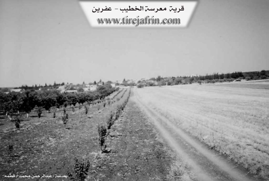
Me'risk / Me'rset el-Xetîb
Based on the book جبل الكرد (عفرين) دراسة جغرافية Çiyayê Kurmênc (Efrîn): A Geographical Study by د. محمد عبدو علي Dr. Mihemed Ebdo Elî:
Me'risk / Me'rset el-Xetîb
641 inhabitants, 16 km distance, 615 m altitude.
Me'ris is a Kurdish word meaning the strong and frightening man. When it is said "Fulan Me'ris" (So and so is Me'ris), it means he is strong and supernatural. It also means "crushing something" according to the Kuranî dictionary. It also carries the meaning of a press for grapes, olives, or similar items. As for X. el-Esedî, he says that Me'rsta means the vine cave. El-Xetîb is a title usually given to preachers in mosques.
It is a medium sized village. Its location has been inhabited since ancient times, and it contains antiquities that indicate urbanization. A mosaic floor was discovered in the village cemetery. There is also a huge stone capital with friezes for fixation. Judging by its shape and its presence near the location where the mosaic was discovered, it is believed that it may have been the head of a worship column.
According to the book عفرين .... نهرها وروابيها الخضراء Efrîn... Her River and Her Green Hills by the writer عبدالرحمن محمد Ebdulrehman Mihemed from the village of Qetme:
Me'rset el-Xetîb
This is a village in Çiyayê Lêlûn. It follows the subdistrict of the Efrîn center and region, in the Aleppo governorate. It is a small village located on a mountainous height in the eastern Lêlûn mountain chain.
It is bordered to the north by a rugged mountain chain, some forest trees, the village of Soxanek, and Xirbet Qunêtra.
It is bordered to the south by a mountain chain, two rugged rocky watercourses, the town of Nubl, and Burj el-Qas.
It is bordered to the west by a slope, a watercourse at the bottom, a rugged mountain chain, and the archaeological village of Brad.
It is bordered to the east by a rugged mountain chain, a watercourse, and the village of Ze'rnîta.
The number of its houses is about 50 houses, and the age of the village is about 80 years, according to the account of the residents living in the village since 1924 who came from the village of Sirîn in the region of Kobanê.
The old dwellings of the village are made of domes, and the modern ones are of stone and reinforced concrete. The electricity network is available there. The road to the village is paved up to the center of the village. It connects to the town of Nubl. There is a primary school on the northeastern side of the village.
Its inhabitants work mainly in raising sheep and cows. They drink from pools and cisterns that collect rainwater. There are some olive trees on the southern and northern sides. Currently, the village has been administratively attached to the Nubl subdistrict in the Ezaz area since 1980.
Village Mukhtar: Beshîr Xelîl Mihemed Reşîd.
Sources
Book: جبل الكرد (عفرين) دراسة جغرافية Çiyayê Kurmênc (Efrîn): A Geographical Study by د. محمد عبدو علي Dr. Mihemed Ebdo Elî.
Book: عفرين .... نهرها وروابيها الخضراء Efrîn... Her River and Her Green Hills by عبدالرحمن محمد Ebdulrehman Mihemed from the village of Qetme.
Preparation and execution:
Manager of Tirej Efrîn site: Ebdulrehman Hacî Osman
20/12/2013
II. Ax û Walat Book 1
THE VILLAGE OF ME’RESKÊ
27.4.2016
The village of ME’RESKÊ was built on a hill with an altitude of about 600 meters above sea level. It is a very ancient village, also known by the name (GUNDÊ ÛSIB) because the elder or founder of the village was named ÛSIB.
The village of ME’RESKÊ is affiliated with the ŞERA district of the EFRÎNÊ canton, located 12 km south of the town of ŞERA and 17 km east of the city of EFRÎNÊ.
164
The name of the village comes from the meaning (me’serê) or press, because there were many grape presses in the village, and this name was given to it.
The surroundings of the village are full of trees, and the courtyards and houses of the village are full of flowers, blossoms, and various trees. In every house, all kinds of flowers and roses are seen. This shows that the people of the village are very fond of agriculture, nature, and adornment.
HEMKULEK was the first person to settle in the village, so all the families of the village are known as the HEMKULEKÊ family, and he was the brother of HEMDÛŞ who settled in KEFERCENÊ.
All the residents of the village are from one family, that is, the HEMKULEK family, which is from the ŞIKAKA tribe. Also, half of the Hemkulekê family has settled in the village of ELKÊ and lives there.
The village of MESERKÊ is not large, but their courtyards are large and spacious, so there are only about 80 houses and around 700 people living in the village.
To the north of the village are Serê Kaniyê and the village of QITMÊ, to the east is also QITMÊ, to the south are Şewarexit Elcoz, and to the west are the villages of KEFERMİZÊ and MEŞALÊ.
165
The entire area around the village is a plain, and its soil is red, which is very rich for agriculture.
It is worth mentioning that the LÊLÛN mountain range starts from this village and ends at the DEŞTA CÛMÊ.
To the west of the village, there is a spring named (Kaniya Kewan) because many partridges used to gather there, and hunters would hunt partridges there. The spring's water still flows, and it has become a place for picnics and excursions. Villagers visit it during the spring and summer seasons and have a good time.
In the village, there is a mosque, a commune, a women's commune, and a primary school where not only children but also women are educated in the Kurdish language.
The people of the village make their living primarily from planting olive trees and fruit orchards with more than 10 types of cherry trees. In 1970, the first tree was planted in this village, and later it spread to all the villages of the EFRÎNÊ canton. Along with it are vineyards, meaning grapes, walnuts, pomegranates, apricots, almonds, apples, and pears.
Along with the trees, the villagers plant fields of wheat, barley, lentils, chickpeas, and vegetables like pumpkins, gourds, eggplants, tomatoes, peppers, and watermelons, for which the village is famous, and they sell these products in the markets of Efrînê.
166
Some families also own livestock like sheep and goats, and some keep honeybees.
There are 6 olive presses, a soap factory, a pickling factory, and a cannery for preserving fruits and vegetables in the village. Many people also work in these factories and support their families.
More than half of the village's residents, both men and women, are employees in the institutions and bodies of the AUTONOMOUS ADMINISTRATION in the town of ŞERA and the city of EFRÎNÊ.
This village is known as the village of intellectuals because the rate of intellectuals and students, both male and female, in the village is very high, and more than 100 people have graduated from university in various fields.
It is worth mentioning that the village school was built by UNICEF in 1985, and it is one of the 5 schools in Syria that were built by this international organization.
To this day, the village of Mereskê is successful in education, and the sign of this is that 3 students from the village won the competition of the Democratic Society Education Committee at the canton level and were awarded. They are: Rodyana Tobal, Îbrahîm Tobal, and Meryem Yûsif.
From 2013 until the beginning of 2016, the village faced attacks from all the gangs, but they never bowed their heads.
167
they did not bow and stood by the YPG and YPJ forces and defended their village. In this way, they wrote clean pages of resistance and heroism in the book of history.
There are 3 martyrs in the village who gave their lives in the NATIONAL LIBERATION STRUGGLE OF KURDISTAN and became symbols of freedom and victory, and the pictures of Ş. Îbo, Sêwas, and Amed Amanos are hung in the village.
The village commune is named Ş. Sêwas.
In June 2013, the Free Army attacked the village from 3 sides: east, south, and west. The people of the village, with the help of the YPG and YPJ, entered the trenches of war. 80% of the village's men stayed in their homes and took up the weapon of honor, while the children, elderly, and women left the village. The gangs used all heavy weapons against the village, firing nearly 100 shells at the village, and the war continued for 12 days. As a result, after the martyrdom of 4 YPG heroes, the gangs fled and could not enter the village, and the YPG fighters advanced. Afterwards, all the people of the village returned to their homes and places, and now they continue their lives with joy and happiness.
Foundation/Origin Information of Me'riskê
Inhabited since ancient times, containing archaeological remains. Locals residing in the village since 1924 came from Sarin village in the Ain al-Arab area.
Source: TirejAfrin Site
Possible Village Name Meaning of Me'riskê
Me'ris is a Kurdish word meaning: the strong and frightening man. It also means "crushing something" or a grape or olive press. Khalil al-Asadi says Ma'rasat means the vineyard cave in Aramaic. Al-Khatib is a title for mosque preachers.
Source: TirejAfrin Site