General Information
Nahiya (Subdistrict)
Cindires
Also Known As
Merwanê Jerin, Merwanê Jerîn, مراونة تحتاني, مرونه تحتاني, مروونة تحتاني, مرونيه تحتاني

Photos
Basic Information about Merwanê Jerin
Source: Tirej Afrin
Foundation Date/Period: approximately 350 years ago
Springs: Kaniya Rutanlî
Hills: Çiyayê Enqele
Other Landmarks: Geliyê Cercem, Deşta Emuqê
Summaries
I. Summary from TirejAfrin Site (English) of Merwanê Jerin
Source: https://www.tirejafrin.com/site/kura%20afrin%20Cindires%20-%20merwane%20jerin.htm
It is stated in the book جبل الكرد (عفرين) دراسة جغرافية Çiyayê Kurmênc (Efrîn): A Geographical Study by د. محمد عبدو علي Dr. Mihemed Ebdo Elî:
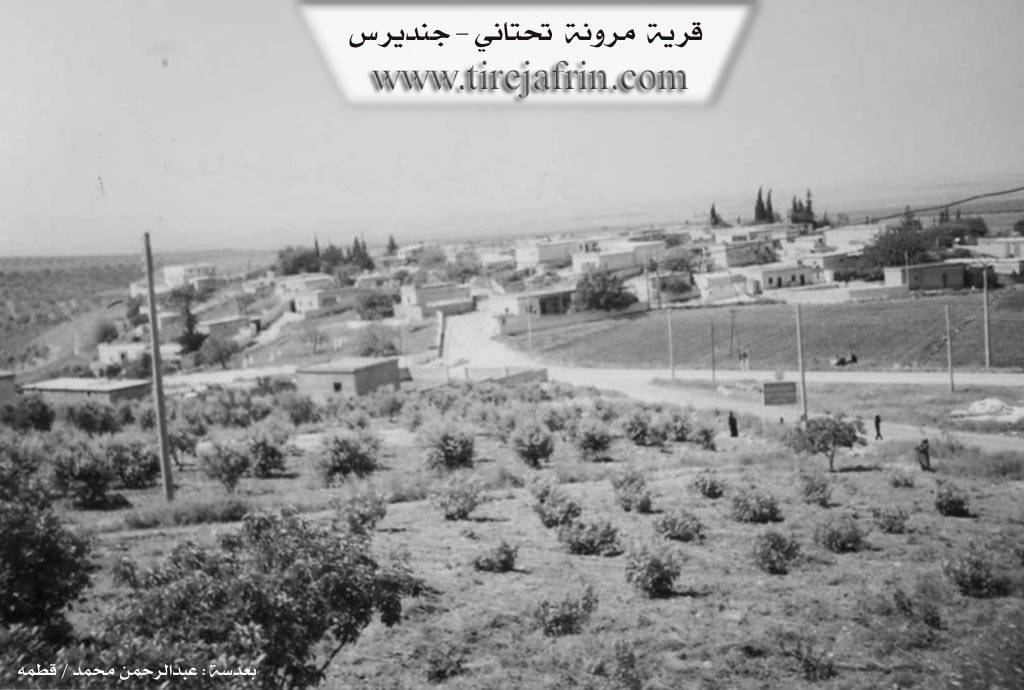
Merwanê Jêrîn / 740 inhabitants - 13 km - 210 m /: It is a small village located on the western slope of the southwestern extension of the Enqele mountain mass. It overlooks the edges of the Emuq plain to the west, and it is built upon an archaeological mound.
It is stated in the book عفرين .... نهرها وروابيها الخضراء Efrîn... Her River and Her Green Hills by the writer عبدالرحمن محمد Ebdulrehman Mihemed from the village of Qetme:
Merwanê Jêrîn: A village in Çiyayê Kurmênc, following the Cindirês district, Efrîn region, Heleb governorate. It is a small village located on the western slope of the southwestern extension of the mentioned mountain mass. It overlooks the edges of the Emuq plain, which possesses fertile alluvial soil, to the west. It is approximately 1 km away from Merwanê Jorîn towards the west, separated by Geliyê Cercem (Jerjem valley), in which water flows to the mouth of the Emuq river.
It is bordered to the north by a mountainous height planted with olive trees and the village of Hêkicê; to the south by a slope, a valley, mountainous highlands, the Emuq plain, and the village of Hemam; and to the east by Geliyê Cercem and the village of Merwanê Jorîn.
The number of its houses is approximately 85, and its age is about 350 years. Its old houses are of mud and stone with flat wooden ceilings or zinc sheets, while the modern ones are cement and have expanded into the outskirts. An electricity network is available, as well as a primary school and a modern mosque on the southern side of the village. The village drinks water from wells, springs, and cisterns that collect rainwater.
It connects to the district center and neighboring villages via an asphalt road. The residents work in the cultivation of olives, grains, and legumes via rain-fed agriculture, and cotton and tobacco via irrigation from artesian wells, alongside raising sheep and goats. It administratively belongs to the village of Merwanê Jorîn. Water flows in the valley on the eastern and southern sides of the village, originating from the spring of Kaniya Rutanlî in the Mabeta district.
Village Mukhtar: Mihemed Hisên
Sources
Book: جبل الكرد (عفرين) دراسة جغرافية Çiyayê Kurmênc (Efrîn): A Geographical Study by د. محمد عبدو علي Dr. Mihemed Ebdo Elî.
Book: عفرين .... نهرها وروابيها الخضراء Efrîn... Her River and Her Green Hills by عبدالرحمن محمد Ebdulrehman Mihemed from the village of Qetme.
Preparation and Execution:
Manager of Navenda Tirej Efrîn: Ebdulrehman Hacî Osman
20/12/2013