General Information
Nahiya (Subdistrict)
Şera
Also Known As
Al-Sim, Omer O, Omer Simo, السيم, عمر سمو, اومر سمو
Families, Clans, etc.
Omer Sîmo

Photos
Basic Information about Omer Simo
Source: Tirej Afrin
Etymology: Named after its first inhabitant Omer Sîmo, and his descendants still inhabit the village. The Arabized name "El-Sîm" has no meaning.
Foundation Date/Period: Approximately 300 years ago
Shrines: Nebî Hûrî
Ruins: Kela Nebî Hûrî
Other Landmarks: Çemê Efrînê, Çemê Sabûn
Summaries
I. Summary from TirejAfrin Site (English) of Omer Simo
Source: https://www.tirejafrin.com/site/kura%20afrin%20%20sheran%20-%20omar%20smo.htm
It is stated in the book جبل الكرد (عفرين) دراسة جغرافية Çiyayê Kurmênc (Efrîn): A Geographical Study: Omer Sîmo, El-Sîm / 647 inhabitants, 545 hectares, 13 km, 550 m altitude /:
Omer Sîmo: The name of its first inhabitant, and his great great grandsons still inhabit the village. The Arabized name "El-Sîm" has no meaning even in the Arabic language.
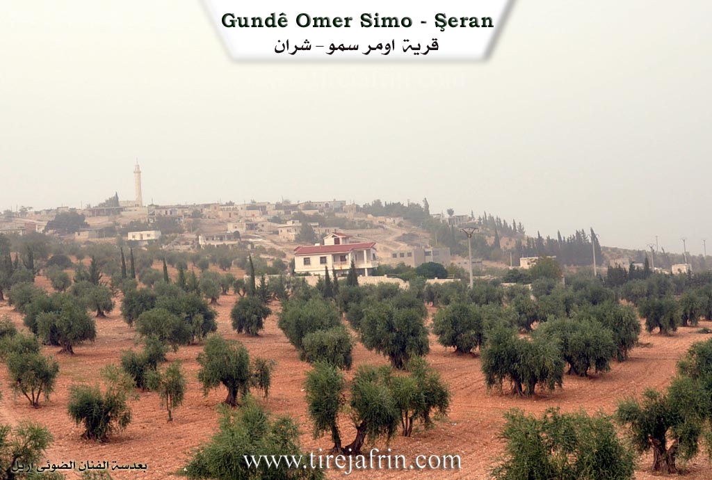
It is a small village that overlooks Çemê Efrînê (Efrîn River) and its tributary Çemê Sabûn (Sabûn River) to the east, and they are about 4 km away from it.
It is stated in the book عفرين .... نهرها وروابيها الخضراء Efrîn... Her River and Her Green Hills: Omer Sîmo: A village in Çiyayê Kurmênc following the township of Şera, region of Efrîn, governorate of Heleb, (630 inhabitants). It is a small village situated on a mountainous rise on the eastern slope of Çiyayê Kurmênc. Its soil is clay. It is about 30 km away from the town of Şera towards the northeast.
It is bordered on the north by a slope and a high mountain chain planted with forest trees, the village of Ebûdan, and the farm of Heftaro; on the south by a slope, a plain planted with olive trees, a valley, and the village of Zeytûnak. It is bordered on the east by a valley, a mountain chain, the archaeological citadel of Nebî Hûrî, the course of the Çemê Sabûn valley, and the village of Şilteh and Mersawa; and on the west by a valley, mountainous heights, and the village of Seerincek.
The number of its houses reaches about 25 houses, and its age is about 300 years. Its old houses are stone and mud with wooden roofs, and the modern ones are stone and cement. Some villas have spread in the south. An electricity network and a water network belonging to the state are available in it. It contains a primary school and a large, modern mosque located in the north of the village.
It is connected to the township by an asphalt road passing near it to Nebî Hûrî and Dêr Sewan. As for the area between the main road and the village, it is a dirt road. The residents work in the cultivation of olives and vines alongside raising sheep and goats. Located to the east of the village is the citadel of Nebî Hûrî with its ruined amphitheater and the shrine of Nebî Hûrî. From the southern side, there is a modern technical press for olives. Its lands are plain like in the south and mountainous and rugged in the north.
Village Mukhtar: Mistefa Omer Sîmo
Sources of Information:
- Book: جبل الكرد (عفرين) دراسة جغرافية Çiyayê Kurmênc (Efrîn): A Geographical Study by د. محمد عبدو علي Dr. Mihemed Ebdo Elî.
- Book: عفرين .... نهرها وروابيها الخضراء Efrîn... Her River and Her Green Hills by عبدالرحمن محمد Ebdulrehman Mihemed from the village of Qetme.
- Studies of Navenda Tirej Soft / Ebdulrehman Hacî Osman.
- Some residents of the villages.
Preparation and Execution: Manager of Tirej Efrîn website: Ebdulrehman Hacî Osman 20/12/2013
Foundation/Origin Information of Omer Simo
The first inhabitant was named Omar Simo, and his descendants still live in the village.
Source: TirejAfrin Site
Possible Village Name Meaning of Omer Simo
Omar Simo: The name of its first inhabitant. The Arabized name Al-Sim has no meaning in Arabic.
Source: TirejAfrin Site