General Information
Nahiya (Subdistrict)
Efrîn
Also Known As
Beit Talita, Bteitech, Pitêtê, بتيته, Bteyteh
Families, Clans, etc.
Efendî, Heyanî, Nazî

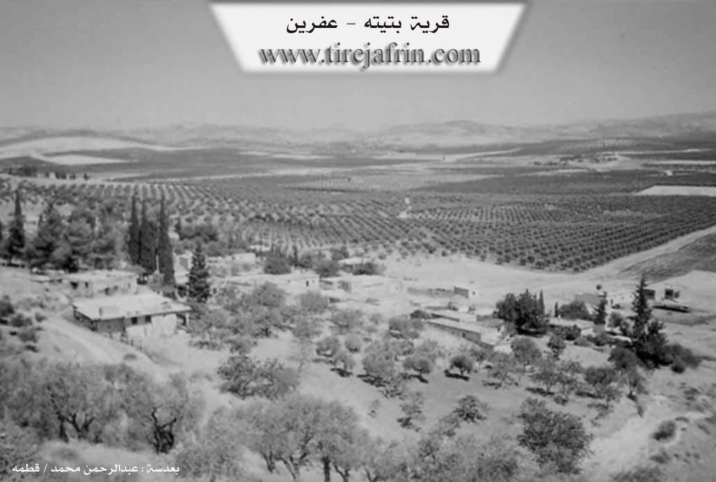
Photos
Basic Information about Pitêtê
Source: Tirej Afrin
Etymology: Aramaic meaning Beyt Telîta (The Hanging) or Beyt Tîna (House of the Fig)
Foundation Date/Period: Late 19th century
Hills: Çiyayê Basûtê, Girê Eyn Darê
Ruins: Girê Eyn Darê
Other Landmarks: Çemê Efrînê
Summaries
I. Summary from TirejAfrin Site (English) of Pitêtê
Source: https://www.tirejafrin.com/site/kura%20afrin%20markaz-pitete.htm
It is stated in the book Çiyayê Kurmênc (Efrîn): A Geographical Study by Dr. Mihemed Ebdo Elî: Pitt, Betîte /288 inhabitants, 452 hectares, 6km, 320m/:
Father Şelhet says that the name is Aramaic from "Beyt Telîta" meaning "The Hanging" /Xêredîn El Esedî, Vol 2, p53/. However, Chorepiscopus Bersûm says it is Aramaic meaning "Beyt Tîna" (House of the Fig) /p56/. We do not know the reason for the difference in meaning within the same language; it may be that the name is not Aramaic to begin with.
The following is stated in the book Efrîn... Her River and Her Green Hills by the writer Ebdulrehman Mihemed from the village of Qetme: Betîte is a village in Çiyayê Kurmênc, belonging to the villages of the center and district of Efrîn, Heleb governorate. It is a village located at the end of the furrowed northern slope of Çiyayê Basûtê (Mount Basuta) at a distance of 800m west of Çemê Efrînê (Afrin River). Its soil is fertile alluvial clay, and it is 6km southwest of Efrîn city with a wide plain in front of it overlooking the area up to Efrîn city and the course of Çemê Efrînê (Afrin River).
It is bordered to the north by a wide and agriculturally fertile plain, the Riya Efrîn-Cindirês (Efrîn-Cindirês road), the village of Babîlît, Cedîde Kirsan Taş, and Efrîn city. To the south, it is bordered by a mountain range and a very high mountainous elevation planted with olive trees and vines, the farm of Bûzîkê, and the village of Kewkebê. To the east, there is a harsh slope, a plain, the course of Çemê Efrînê (Afrin River), the archaeological site of Girê Eyn Darê, and the village of Eyn Darê. To the west, there is a wide agricultural plain, the village of Kefer Betre, the farm of Hesûn, Şêx Ebdurrahman, and the village of Telef.
The number of its houses reaches about 16 houses and its age is about 125 years. Its old houses are made of stone and mud with wooden roofs, while the modern ones are of stone with roofs of reinforced concrete. According to the account of one of the elderly owners of the village, he said that the old location of the village was beside Çemê Efrînê (Afrin River) to the west, and as a result of the prevalence of diseases, the village was forced to move to the current elevated location to avoid diseases.
An electricity network and a primary school are available in the village, as well as a paved dirt road reaching the center of the village. The residents drink from wells and cisterns. The population works mainly in the cultivation of grains, olives, vegetables, and cotton, and in raising sheep and goats. Among the families present in the village are: Efendî, Nazî, and Heyanî.
Sources
Book: جبل الكرد (عفرين) دراسة جغرافية Çiyayê Kurmênc (Efrîn): A Geographical Study by د. محمد عبدو علي Dr. Mihemed Ebdo Elî.
Book: عفرين .... نهرها وروابيها الخضراء Efrîn... Her River and Her Green Hills by عبدالرحمن محمد Ebdulrehman Mihemed from the village of Qetme.
Studies of Navenda Tirej Efrîn / Ebdulrehman Hacî Osman.
Preparation and Execution:
Manager of Tirej Efrîn website: Ebdulrehman Hacî Osman
20/12/2013
Foundation/Origin Information of Pitêtê
The village's old location was beside Afrin River to the west. Due to frequent diseases, the village was forced to move to its current elevated location.
Source: TirejAfrin Site
Possible Village Name Meaning of Pitêtê
Father Shelaht says the name is Aramaic from 'Beit Talita' meaning 'the suspended one'. Al-Khuri Barsoum says it is Aramaic meaning 'House of Figs'.
Source: TirejAfrin Site