General Information
Nahiya (Subdistrict)
Bilbilê
Also Known As
Al-Mashriqa, Qestelê Miqdê, Qestelê Miqdêd, Sharqan Farm, قسطل مقداد, مزرعة شرقان، المشرقة, قسطل مختار

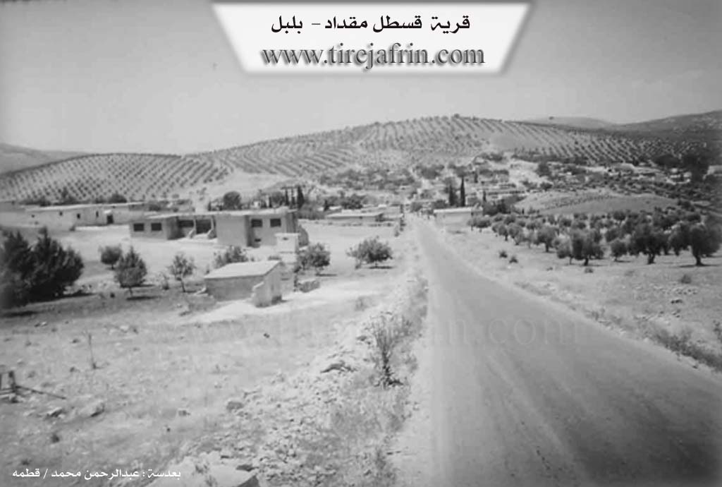
Photos
Basic Information about Qestelê Miqdêd
Source: Tirej Afrin
Etymology: Qestel is the name of a well and ancient water source located on the western side of the archaeological hill east of the village. Miqdad is the name of one of the ancient residents of the village.
Foundation Date/Period: Late fifth decade of the twentieth century
Springs: Qestel
Hills: Şerqiya, Gaz
Wells: Qestel
Summaries
I. Summary from TirejAfrin Site (English) of Qestelê Miqdêd
Source: https://www.tirejafrin.com/site/kura%20afrin%20%20%20bilbile%20-%20q%20makdad.htm
It is stated in the book جبل الكرد (عفرين) دراسة جغرافية Çiyayê Kurmênc (Efrîn): A Geographical Study regarding Qestel Miqdd Qestel Miqdad, farm of Şerqan388 inhabitants, 7km, 560m/:
Qestel: This is the name of a well and ancient water source located on the western side of the archaeological hill found to the east of the village. Miqdad is the name of one of the ancient residents of the village, and he still has descendants in it.
It is a large village located on the eastern slope of Mount Şerqiya. It contains small workshops for some building materials, blacksmithing, and the repair of agricultural machines. It is a modern village established in the late fifth decade of the twentieth century. The old village was located on the peak of Gaz to the west of it by about 1km, and its inhabitants abandoned it for its current location.
It is stated in the book عفرين .... نهرها وروابيها الخضراء Efrîn... Her River and Her Green Hills:
Qestel Miqdad: A village in Çiyayê Kurmênc following the Bilbile district, Efrîn region, Heleb governorate. It is a very large village located in a low valley and on both sides of the Riya Bilbile-Meydankê (Bilbile-Meydankê road).
It is bounded on the north by a mountain range planted with olive trees, the village of Okanlî, and a valley passing beside the village; on the south by a valley, a depression, and the village of Kutanlî; on the west by a mountain range planted with olive trees and the village of Şerqiyanlî; and on the east by a high mountain range and the village of Şêx Xûruz.
An electricity network and drinking water belonging to the state are available in it. A paved road passes through its center heading to Bilbile and the neighboring villages. It contains a primary and preparatory school, a mosque, some commercial and service shops, and repair workshops, given that the village is located on the easy public road.
This village and its lands are affiliated with the village of Şerqiyanlî, and it is similar to a satellite of it. Its inhabitants are from the village of Şerqiyanlî and some neighboring villages due to its location on the public road. The number of houses is about 150, and the age of the village is modern, about 35 years or a little more. The main source of income is agriculture and other service works. It contains a telephone center for service.
Sources of Information:
- Book: جبل الكرد (عفرين) دراسة جغرافية Çiyayê Kurmênc (Efrîn): A Geographical Study by د. محمد عبدو علي Dr. Mihemed Ebdo Elî.
- Book: عفرين .... نهرها وروابيها الخضراء Efrîn... Her River and Her Green Hills by عبدالرحمن محمد Ebdulrehman Mihemed from the village of Qetme.
- Studies of Navenda Tirej Soft / Ebdulrehman Hacî Osman.
- Some residents of the villages.
Preparation and execution: Manager of the site Tirej Efrîn: Ebdulrehman Hacî Osman 20/12/2013
Foundation/Origin Information of Qestelê Miqdêd
The old village was located on Gazê Summit, 1km west, and its inhabitants migrated to the current location. Its inhabitants are from Sharqiyanli Village and neighboring villages.
Source: TirejAfrin Site
Possible Village Name Meaning of Qestelê Miqdêd
Qastal is the name of an old well and water source. Miqdad is the name of one of the old inhabitants of the village.
Source: TirejAfrin Site