General Information
Nahiya (Subdistrict)
Şera
Also Known As
Kafar Jannah, Kefir Cenê, Serê Kaniyê, كفرجنة, كفرجنه
Families, Clans, etc.
Emer, Hask, Hemdûş, Osk, Osman, Tobo, Îbş, Şebab

Photos
Basic Information about Serê Kaniyê
Source: Tirej Afrin
Etymology: The popular name is Ser Kaniy, meaning 'Head of the Spring' (ser + kaniy). The name Kefercenê is of Aramaic origin from 'Kefer Cinta', meaning 'Village of the Garden' (kefer + cinta).
Foundation Date/Period: Approximately 100 years ago
Springs: Kaniya Kefercenê
Hills: Çiyayê Menan, Çiyayê Hemûdê û Sadiq
Shrines: Menan, Sadiq
Other Landmarks: Xeta Trêna Heleb-Istenbol
Summaries
I. Summary from TirejAfrin Site (English) of Serê Kaniyê
Source: https://www.tirejafrin.com/site/kura%20afrin%20%20sheran%20-%20kafrjanh.htm
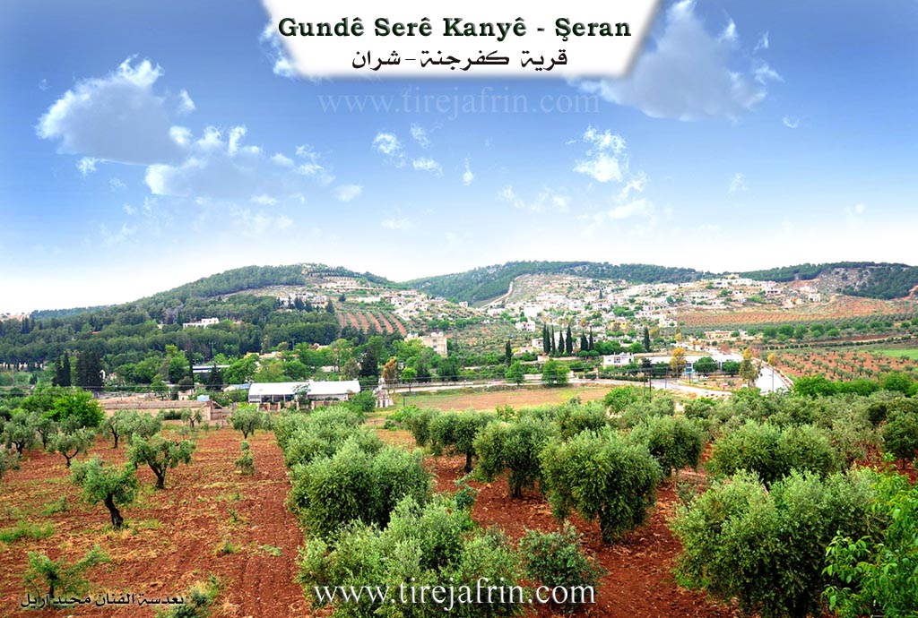
It is stated in the book Çiyayê Kurmênc / Efrîn / A Geographical Study: Ser Kaniy, Kefercenê / 771 inhabitants - 180 houses - 7km - 560m /:
The popular name is Ser Kaniy "Head of the Spring," which is a Kurdish designation, and the local inhabitants do not call it by any other name. As for the name Kefercenê, Al-Asadi (Part 6, page 374), quoting Father Shalhat, states that it is an Aramaic name from "Kefer Cinta," meaning "Village of the Garden."
It is a small village located at the bottom of the southern slope of a plateau called Çiyayê Menan. Beside it bursts forth the Kefercenê spring, which supplies a part of the city of Efrîn with drinking water, with a flow rate of 300 liters per second. A train line passes next to it. It is a major transportation node leading to the districts of Şeran and Bilbil towards the Turkish border; therefore, a small market has emerged beside it, along with a number of industrial workshops for the maintenance of agricultural machinery and vehicles, two fuel stations, and restaurants frequented by picnickers. It contains a camp for the Baath Vanguards in the Aleppo governorate and a health center. The location of the village is a beautiful summer resort. The distance between the villages of Qetme and Kefercenê, spanning about 2 km, has turned into a residential tourism area, and a branch of a private university has been opened there.
It is stated in the book Efrîn... Her River and Her Green Hills: Kefercenê: A village in Çiyayê Kurmênc, following the Şeran district, Efrîn region, Aleppo governorate. It is a small village located between two mountains: the western one is called Çiyayê Menan, named after the Menan shrine at the highest peak of the mountain, while the eastern one is called Çiyayê Hemûdê û Sadiq, named after the Sadiq shrine at the highest eastern point of the mountain.
It sits at the bottom of the southern slope of a limestone plateau furrowed by torrential valleys and overlooks a low rift valley. It is bordered on the north by Xerabê Şeran and Metîna; on the south by a fertile clay slope, the Xeta Trêna Heleb-Istenbol (Aleppo-Istanbul railway line) passes nearby, along with the village of Mersewa Xetîb; on the east by a mountainous elevation and the high village of Qetme which is close to it; and on the west by a mountain chain, the Kefercenê spring, the Vanguards camp, and the village of Meşelê.
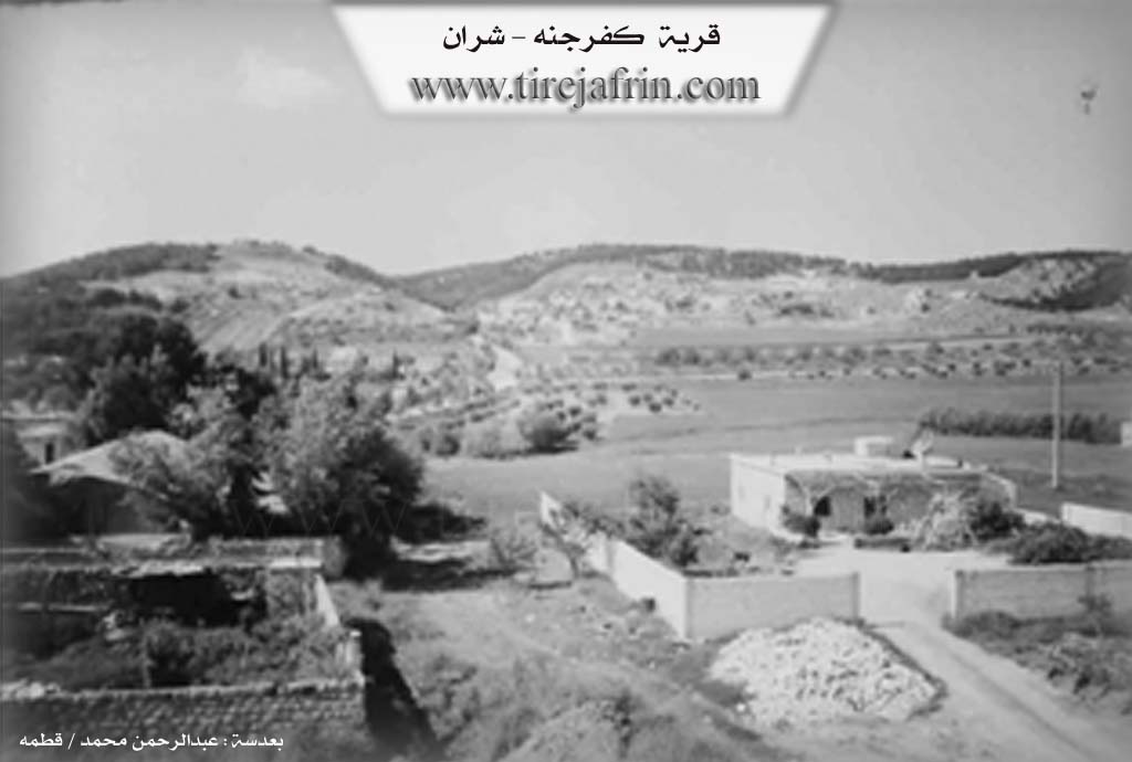
The number of its houses is about 50, and the age of the village is about 100 years. Its old houses are made of mud and stone with wooden roofs, while the modern ones are of stone and reinforced concrete, spread over the hills up to the Riya Heleb-Efrîn (Aleppo-Efrîn road). An electricity network is available, as well as drinking water from the Kefercenê spring since 1971. It has a primary school, a health center, an extension unit, and a telephone center. It belongs to the Qetme municipality. There are several paved streets in the village, especially the main street extending from the beginning of the railway to the center of the village.
The residents of the village work in the cultivation of grains, olives, vines, and almonds, as well as irrigated agriculture including vegetables, pomegranates, apricots, and walnuts. In the northern part of the village, the state established a forestry area planted with pine trees, whereas in the southern part, there are a number of orchards and a water spring. Restaurants and cafes are widespread there, frequented by residents of Aleppo and neighboring areas. The restaurant located within the pine forest was converted into a permanent center for the Vanguards camp in Aleppo governorate. The village connects to neighboring areas through the main road coming from Aleppo.
Its population, according to the civil registry on December 31, 2004, is 750 people. The first to dwell there since the establishment of the village was the Hemdûş family (Osman - Osk - Hask - Şebab - Îbş - Tobo - Emer ...).
Among the holders of higher degrees in the village: Mistefa Osman / Doctorate in Arabic Literature / Russia.
Among the literary figures is the poet Axîn Welat (Semîre Şebab), and among the artistic figures is the artist Neîm Şebab.
Village Mukhtar: Enwer Osman.
Sources of Information:
- Book: جبل الكرد (عفرين) دراسة جغرافية Çiyayê Kurmênc (Efrîn): A Geographical Study by د. محمد عبدو علي Dr. Mihemed Ebdo Elî.
- Book: عفرين .... نهرها وروابيها الخضراء Efrîn... Her River and Her Green Hills by عبدالرحمن محمد Ebdulrehman Mihemed from the village of Qetme.
- Studies of Navenda Tirej Soft / Ebdulrehman Hacî Osman.
- Some residents of the villages.
Preparation and execution: Manager of the Tirej Efrîn website: Ebdulrehman Hacî Osman 20/12/2013
Foundation/Origin Information of Serê Kaniyê
The first to inhabit since the village's establishment was the Hamdoush family.
Source: TirejAfrin Site
Possible Village Name Meaning of Serê Kaniyê
The popular name is Serê Kaniyê "head of the spring" and it is a Kurdish name. The name Kafar Jannah is an Aramaic name from "Kafar Jinta" meaning village of the garden.
Source: TirejAfrin Site