General Information
Nahiya (Subdistrict)
Cindires
Also Known As
Khaltan Western, Xaltan Xarbe, Xeltê Xerbî, خالطان غربي
Tribes
Xalta
Families, Clans, etc.
Xalid, Xele, Şêxne
Photos
Basic Information about Xeltê Xerbî
Source: Tirej Afrin
Etymology: The name Xalta is the name of a region and a known Kurdish tribe in Kurdistan, found in Behdînan in southern Kurdistan. It is also the name of the Xaltî or Xaldî people, one of the descendants of the Kurdish people.
Foundation Date/Period: Approximately 400 years ago
Other Landmarks: Geliyê Xalta
Summaries
I. Summary from TirejAfrin Site (English) of Xeltê Xerbî
Source: https://www.tirejafrin.com/site/kura%20afrin%20Cindires%20-%20xaltan%20xarqe.htm
The following text states what came in the book جبل الكرد (عفرين) دراسة جغرافية Çiyayê Kurmênc (Efrîn): A Geographical Study by د. محمد عبدو علي Dr. Mihemed Ebdo Elî: Xalta, Xaltan, Xeltan / 550m altitude, 575 hectares, 15km distance /:
Xalta: This is the name of a region and a known Kurdish tribe in Kurdistan. Members of this tribe are found in Behdînan in southern Kurdistan (Lerch, p. 52). It is also the name of the Xaltî or Xaldî people, one of the descendants of the Kurdish people.
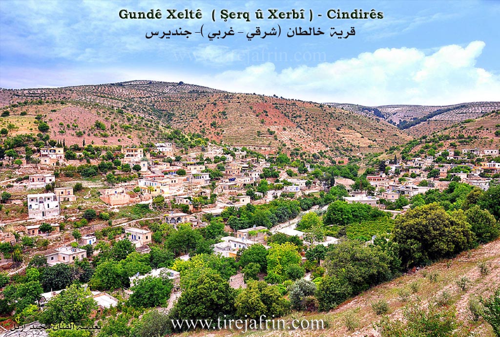
It is a medium sized village located at the beginning of Geliyê Xalta (Khaltan valley). The valley splits the village into two parts: Northeastern (1206 inhabitants, 565m altitude) and Southwestern (977 inhabitants, 560m altitude). They are surrounded by mountain heights covered with pine forests and olive fields. The village site is rich in antiquities, evidenced by huge building stones, many archaeological finds, and pieces of pottery. Its location is also rich in groundwater and surface springs.
The following states what came in the book عفرين .... نهرها وروابيها الخضراء Efrîn... Her River and Her Green Hills by the writer عبدالرحمن محمد Ebdulrehman Mihemed from the village of Qetme:
Xalta Rojava (West Khaltan): This is a village in Çiyayê Kurmênc, administratively belonging to the Cindirês district of the Efrîn area, Heleb governorate. It is a large village located on the edges of the collection basin of Geliyê Xalta, which descends toward the southwest and splits the village into two sections: Xalta Rojava and Xalta Rojhilat. It is surrounded by mountain heights with limestone rocks. It is 15km away from the town of Cindirês to the north and east.
It is bordered to the north by a high mountain range planted with olive trees and forest trees and the village of Îkî Axûr. It is bordered to the south by a high mountain range planted with olive trees and vines and the village of Çeqelê Cûmê. It is bordered to the west by a deep watercourse planted with olive, walnut, almond, and pomegranate trees, a mountain rise, and the villages of Kûrda and Miska Jorîn. It is bordered to the east by a high mountain range planted with olive trees and the villages of Çolaqa and Kurkan.
The number of its houses is approximately 100 houses, and the age of the village is about 400 years according to the statements of one of the elderly residents of the village. He mentioned that the first to build the village did so when a shepherd discovered the presence of an old Roman well while drinking water from under rocks in the ground. Residents of neighboring villages then began settling in this location.
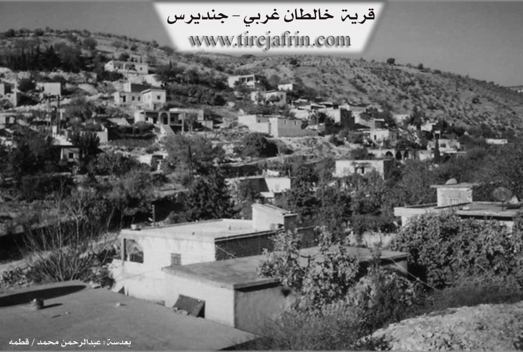
Its old residences are made of stone and mud with wooden roofs, while modern cement construction extends onto the slopes overlooking the valley in terraces toward the north due to the slope of the site. An electricity network, a primary school, an agricultural cooperative society, and a mosque are available in the village. It connects to the district center via a paved road. The village drinks from cisterns that collect rainwater and from a well in the center of the village.
Its inhabitants work in rain fed agriculture on an area of 575 hectares, cultivating olive, almond, walnut, and vine trees, as well as grains and legumes, alongside raising sheep and goats. A portion of its inhabitants migrates internally to work in the city of Heleb and other cities due to the narrowness of agricultural lands and their lack of fertility. The farm of Xalta Rojhilat is attached to it.
Among the families present in the village are: the Xalid family, the Xele family, and the Şêxne family.
The village mukhtar is Mr. Tahir Ne'so.
Naturally, there are many university degree holders across various specializations.
Preparation and execution:
Manager of Tirej Efrîn site: Ebdulrehman Hacî Osman
20/12/2013
Sources
Book: جبل الكرد (عفرين) دراسة جغرافية Çiyayê Kurmênc (Efrîn): A Geographical Study by د. محمد عبدو علي Dr. Mihemed Ebdo Elî.
Book: عفرين .... نهرها وروابيها الخضراء Efrîn... Her River and Her Green Hills by عبدالرحمن محمد Ebdulrehman Mihemed from the village of Qetme.
Studies of Navenda Tirej Soft / Ebdulrehman Hacî Osman.
Some residents of the villages.
Foundation/Origin Information of Xeltê Xerbî
The first person to build the village was when one of the shepherds discovered while drinking water from under rocks in the ground the existence of an old Roman well, so the people of neighboring villages began to settle in this location.
Source: TirejAfrin Site
Possible Village Name Meaning of Xeltê Xerbî
Name of a region and well-known Kurdish tribe in Kurdistan, found in Bahdinan from southern Kurdistan. It is also the name of the "khalty, khaldi" people, one of the grandsons of the Kurdish people.
Source: TirejAfrin Site