General Information
Nahiya (Subdistrict)
Cindires
Also Known As
Jiqallali Joum, Joum, Çeqela Cûmê, Çeqelê Cûmê, جقللي جوم, جوم, چقللي جوم
Tribes
Çeqellî
Families, Clans, etc.
Cimke, Emo Şêxe, Ferxo, Hemze Mero, Heso, Kurd, Mala Birîm, Mala Cimko, Mala Elcûkê, Mala Ferxê, Mala Hesen Sûranî, Mala Hesen Zemû, Mala Kurd, Mala Reşî Sêvo, Mala Sûskulekê, Mala Tirkû, Malbata Ebû Yûsif, Mol Betê, Molê Break, Mûso, Ne'so, Sozklak, Turko, Urta Çaqala, Zimo, Îbo
Photos
Basic Information about Çeqelê Cûmê
Source: Ax û Welat
Caves: Şikefta Kersendaşê
Number of Caves: 43
Shrines: Kînisîk
Ruins: Kînisîk
Other Landmarks: 'Oşka
Source: Afrin 366
Foundation Date/Period: 350 to 400 years ago
Number of Caves: 60
Ruins: Biyê Gund
Wells: Bîra Rûmanî
Other Landmarks: Geliye Çîçikê
Summaries
I. Summary from TirejAfrin Site (English) of Çeqelê Cûmê
Source: https://www.tirejafrin.com/site/kura%20afrin%20Cindires%20-%20ceqele%20cume.htm
The following is stated in the book جبل الكرد (عفرين) دراسة جغرافية Çiyayê Kurmênc (Efrîn): A Geographical Study by د. محمد عبدو علي Dr. Mihemed Ebdo Elî:
Çeqellî Cûm:
The name "Çeqel" means "jackal" (ibn awa) in Kurdish. "Çeqellî" is also the name of a Kurdish tribe. As for "Cûm," it refers to the Cûme plain, and was attributed to the village to distinguish it from other villages bearing the same name located in the Şiyê district.
Administrative data: 1205 inhabitants, 325 houses, 8km from the center, 440m altitude.
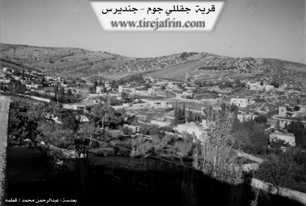
It is a small village located on both sides of a valley that penetrates it from the north towards the south.
The following is stated in the book عفرين .... نهرها وروابيها الخضراء Efrîn... Her River and Her Green Hills by the writer عبدالرحمن محمد Ebdulrehman Mihemed from the village of Qetme:
Çeqellî Cûm:
A village in Çiyayê Kurmênc following the Cindirês sub-district, Efrîn region, Heleb governorate. It is a small village located on the southern slope of Çiyayê Kurmênc, between three mountainous heights and three watercourses: the first to the west, the second to the north, and the third to the east. These meet in an area in the village valley south of the village.
It is bordered to the north by mountainous heights planted with olive trees and grapevines, and the village of Xaltan (Eastern and Western). To the south, it is bordered by Geliyê Sîlî (Sîlî valley) which heads towards the Cindirês plain and the Efrîn valley, and the village of Burc Hemûş. To the west, it is bordered by mountainous heights planted with olive trees and forest trees, and the village of Miska Jorîn and Miska Jêrîn. To the east, it is bordered by mountainous heights planted with olive trees and the village of Aşkan Şerqî.
The number of its houses reaches about 75 houses, and its age is approximately 400 years according to the statements of the village Mukhtar. Its old houses are made of stone and mud with flat wooden roofs, while the modern ones are cement and stone. The village has expanded to the west and east and along both sides of the public road. Geliyê Sîlî (Sîlî valley) passes through the center of it, coming from the north to the southern side of the village towards the Cindirês plain.
A water network is available, with drinking water supplied from the well of the village of Miska Jêrîn which belongs to the state. There is also an old Roman well in the north that was used for drinking water in the past, with a very old tree near the well dating back hundreds of years. Its residents work in the cultivation of olives, grapevines, and grains (rain-fed), and irrigated summer vegetables, walnuts, and almonds via artesian wells, alongside raising sheep and goats. It is connected to the sub-district by an asphalt road reaching the center of the village, passing through several neighboring villages.
Among the families present in the village are:
Cimke family (now present in the village of Erebû)
Turko family
Sozklak family (sub-families: Ne'so, Îbo, Heso)
Mûso family (Êzîdî)
Kurd family
Ferxo family (Êzîdî)
Emo Şêxe family
Zimo family (Sorani)
It is mentioned that the late artist Îbrahîm Turko, who is considered one of the early artists in the Efrîn region, is from this village. There are many university degree holders. Furthermore, the journalist Nidal Yûsif and the buzuq player Wehîd Yûsif Kurd (Ebû Şiyar, the grandson of Îbrahîm Turko) are from this village.
Village Mukhtar: Ebdulrehman Mistefa
Sources:
- Book: جبل الكرد (عفرين) دراسة جغرافية Çiyayê Kurmênc (Efrîn): A Geographical Study by د. محمد عبدو علي Dr. Mihemed Ebdo Elî.
- Book: عفرين .... نهرها وروابيها الخضراء Efrîn... Her River and Her Green Hills by عبدالرحمن محمد Ebdulrehman Mihemed from the village of Qetme.
Preparation and Execution:
- Manager of Tirej Efrin Website: Ebdulrehman Hacî Osman
- 20/12/2013
II. Summary of Çeqelê Cûmê from Ax û Welat
Source: https://www.youtube.com/watch?v=VVuuuQuM7eA
The village of Çeqela Cûmê, located in the Cindirêsê district of the Afrin region, is a community of approximately 100 households where Êzîdî and Misilman families live together in close fraternity. The history of the village is rooted in the Ottoman era. According to the elder Apê Nebî, the village was founded by a man named Sarim Ehmed. Sarim Ehmed was a rebellious figure ("qebedayî") who defied the dewleta Osmanî (Ottoman state). He was eventually pursued by forces from Stenbol, captured, and taken to Heleb (Aleppo) where he was executed by the governor.
Following Sarim Ehmed, the first major family to settle and rule the area was Mala Cimko. However, internal conflict and violence eventually led to their decline. They were succeeded by the Mala Sûskulekê (also referred to as the family of Xaletê Îbram). Over time, other families arrived to shape the village's demographics, including Mala Tirkû, Mala Kurd, Mala Ferxê, Mala Reşî Sêvo, Mala Elcûkê, Mala Hesen Zemû, Mala Hesen Sûranî, and Mala Birîm.
The village is historically significant for its cave dwellings; there are 43 caves in Çeqela Cûmê, and the ancestors of the current residents originally lived in these caves before constructing the stone houses that now stand. A notable historical landmark is the Kînisîk, an ancient ruin believed to be a church or synagogue of Rûm (Byzantine) or Ermenî origin, estimated by locals to be 1,000 years old. Near this ruin lies a deep cave system known as Şikefta Kersendaşê, located in the direction of 'Oşka. Local legends suggest this cave extends for kilometers, potentially reaching the nearby village of Aşke, though explorers have only managed to penetrate about 100 meters.
Culturally, the village preserves distinct culinary and oral traditions. The women prepare a traditional dish called Kutayî, made from beaten wheat ("silef") and meat. The village is also home to Apê Hesen, an oral history enthusiast who has maintained a collection of cassette tapes for decades, preserving Kurdish epics and stories about figures like Cebelî, Xelîl Beg, Dewrêş, and Salihê Naso. He recounts the tradition of "Takirma", rhyming, teasing storytelling, historically performed by figures such as Reşîdê Elî and Mirodê Kûr. The community's artistic spirit continues through two local performance groups: Koma Şehîd Şîlan for youth and Koma Şehîd Zeredeşt for children.
II. Summary of Çeqelê Cûmê from Afrin 366
Source: https://www.youtube.com/watch?v=OyFnK_jmPTM
The village of Çeqelê Cûmê, located near the town of Cindirês in the Afrin region, is a settlement with a history spanning approximately 350 to 400 years. According to local elders, the village was established by ancestors who originally inhabited the area's numerous caves. The documentary notes that there are roughly 60 caves within the village boundaries, which served as the primary dwellings for the population in the distant past before modern stone houses were constructed.
The history of Çeqelê Cûmê is defined by a local migration from a lower lying area known as Biyê Gund. An elder explains that the community originally resided in the valley at Biyê Gund but eventually relocated uphill to the current site. This movement was driven by the necessity to be closer to water sources, specifically a landmark known as Bîra Rûmanî or the Roman Well. In earlier times, the proximity to such wells and springs dictated the settlement patterns of the villagers.
Socially, the village is described as being exceptionally cohesive. While there are approximately 100 to 120 households, the residents consider themselves to be "one house" or a single lineage, referred to as Urta Çaqala. Within this broader kinship group, specific families and households are mentioned, including Mol Betê, Molê Break, and the house of Hemze Mero. The village has faced significant demographic shifts, with an estimated 80 percent of the population having emigrated to Europe, leaving many elderly residents like Ebû Yûsif and Benevş to maintain their ancestral homes and agricultural lands, which include olive groves and pepper fields.
The landscape around Çeqelê Cûmê is characterized by the Geliye Çîçikê valley and the rugged terrain typical of Çiyayê Kurmênc. Despite the heavy migration, the remaining residents maintain a strong connection to their land and history, preserving the memory of the Roman Well and the caves that once sheltered their forefathers.
Transcriptions and Subtitles
| Source | Video | Subtitles | Transcript |
|---|---|---|---|
| Afrin 366 1 | Watch Video | Download SRT | View Transcript |
| Ax û Welat 1 | Watch Video | Download SRT | View Transcript |
Foundation/Origin Information of Çeqelê Cûmê
Established by six primary family lineages, known by the old term "şiket."
Source: Afrin 366 Transcript
Possible Village Name Meaning of Çeqelê Cûmê
"Çeqel" in Kurdish means "illegitimate son." "Çeqelê" is also the name of a Kurdish tribe. "Joum" is the name of the Joumeh plain, added to distinguish it from other villages with the same name.
Source: TirejAfrin Site
The name is derived from a combination of its status as a settlement ("waro"), its proximity to Cindirêsê, and a local plant known as "cewîr."
Source: Afrin 366 Transcript