General Information
Nahiya (Subdistrict)
Mabeta
Also Known As
Hec Qasimo, Hec Qasma, Hecîqasma, حاج قاسم, حاج قاسملي, حاج قاسملي، حج قاسما, Ḧaj Qasim, Ḧec Qasma, حج قوسمو
Tribes
Biyo
Families, Clans, etc.
Azad, Hec Qasim, Heydûn, Kirtonca, Mala 'Omê, Mala Extiyê, Mala Hemê, Mala Hesen, Mala Hesenê 'Eyrê, Mala Xelê, Mala Êhûyê, Mala Êhûş Dêla, Mala Ûsê, Mişbûk, Omer, Remezan, Setîf, Soro

Photos
Basic Information about Ĥec Qasma
Source: Ax û Welat
Etymology: Named after the founder Hecî Qasim
Foundation Date/Period: Approximately 750 years ago
Springs: Kaniya Hecî Qasima, Kaniya Mist Eşûra
Hills: Serê Qûça, Serê Gazê, Çiyayê Çizirkê, Çiyayê Omê, Çiyayê Extiyar, Çiyayê Heydo, Çiyayê Benê Hêra, Çiyayê Çatê, Qûça Gogayê
Other Landmarks: Geliyê Dûlê, Wadî Cercim, Geliyê Kûmrê, Baniya Ozê, Çiyayê Xastiyan
Source: Afrin 366
Etymology: Named after an ancestral location called Haleta Hec Qosimo or Warê Hec Qosimo in the Behdîna region, from where the founders migrated
Hills: Rece, Aljoro, Çûmezin
Ruins: Mistaşûra, Koxre
Trees: Merx
Other Landmarks: Berka, Me'serkê
Summaries
I. Summary from TirejAfrin Site (English) of Ĥec Qasma
Source: https://www.tirejafrin.com/site/kura%20afrin%20%20%20mebetli%20-hec%20qasma.htm
It is stated in the book جبل الكرد ( عفرين ) دراسة جغرافية Çiyayê Kurmênc (Efrîn): A Geographical Study by د. محمد عبدو علي Dr. Mihemed Ebdo Elî: Hec Qasma, Hec Qasimlî, Hec Qasim /574 inhabitants, 277 hectares, 15km, 600m/:
Qasim is the local proper name of its first inhabitant, and Hec is his religious title.
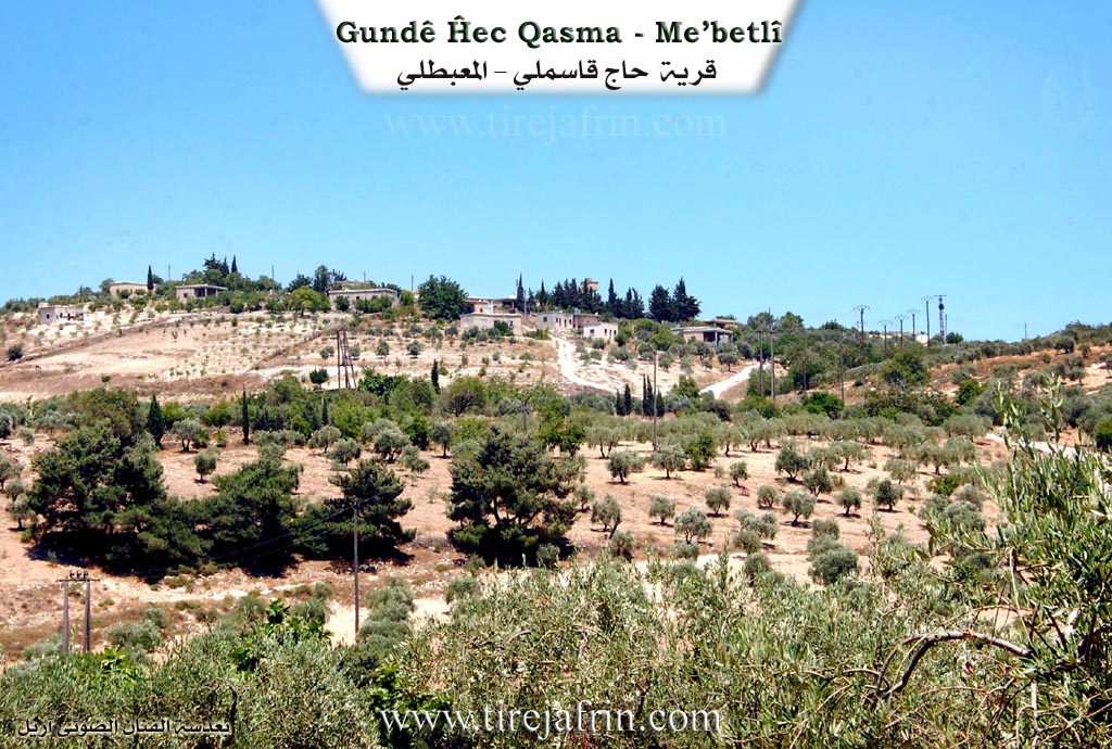
It is located on the southern slope of a plateau overlooking the Xastiya valley, where oak forests, pastures, and olive fields are spread.
And it is stated in the book: عفرين .... نهرها وروابيها الخضراء Efrîn... Her River and Her Green Hills by the writer عبدالرحمن محمد Ebdulrehman Mihemed from the village of Qetme regarding Hec Qasimlî: It is a village in Çiyayê Kurmênc, belonging to the subdistrict of Mabeta, district of Efrîn, governorate of Heleb. It is a small village located in the middle section of the mentioned mountain, on the southern slope of a marly limestone plateau sloping toward the southeast, furrowed by gullies and covered with oak forests and pastures. It is 15km away from the town of Mabeta toward the southwest. Its soil is clay and suffers from erosion.
It is bordered to the north by a high mountain range planted with forest trees and the villages of Turmişa and Maxarçix; to the south by a mountain slope, a flood valley, the Cercim valley, and the villages of Rûtana and Îkî Axûr; to the west by a slope, a flood valley, a mountain range, the Cercim valley, and the village of Dalyana; and to the east by mountainous highlands, a flood valley, and the village of Mist Eşûra.
The number of its houses reaches 50 houses and its age is approximately 250 years. Its dwellings are of stone and mud with flat wooden roofs, while the modern ones are made of stone and cement and are spread on the outskirts of the village. An electricity network and a primary school are available in the village. The village drinks from cisterns where rainwater collects in winter or from artesian wells dug next to the houses, and currently from a well belonging to the state south of the village. Its residents work in rain fed agriculture on an area of 277 hectares with olive trees and grains, alongside raising sheep, goats, and cows. It is connected to the subdistrict center and neighboring villages by a paved road up to the center of the village. Among its most important families are the Hec Qasim family and the Mişbûk family.
Village Mukhtar: Zahid Ixtiyar
Sources:
- Book: جبل الكرد ( عفرين ) دراسة جغرافية Çiyayê Kurmênc (Efrîn): A Geographical Study by د. محمد عبدو علي Dr. Mihemed Ebdo Elî.
- Book: عفرين .... نهرها وروابيها الخضراء Efrîn... Her River and Her Green Hills by عبدالرحمن محمد Ebdulrehman Mihemed from the village of Qetme.
Preparation and execution:
- Manager of the Tirej Efrîn site: Ebdulrehman Hacî Osman
- 20/12/2013
II. Summary of Ĥec Qasma from Ax û Welat
Source: https://www.youtube.com/watch?v=SX5PUtIWmSA
The village of Hecî Qasima is a historic settlement located in the Mabeta district of the Efrîn region specifically within the mountainous area known as Çiyayê Xastiya or Xastiyan. The village was founded approximately 750 years ago and is named after its original founder Hecî Qasim. According to local oral history Hecî Qasim initially resided in Sîdankê or the Cindirês area before moving to the Xastiya mountains to escape difficult conditions and taxes in the plains. He established the village alone living in a cave and raising livestock.
The inhabitants of Hecî Qasima predominantly belong to the Biyo tribe. Their ancestors migrated from Dêrsiwan stopping briefly in Baedîna and Sînganê before settling in the current location due to its defensive geography and availability of resources. The social structure of the village evolved from the three sons of the founder establishing the primary families known as Mala 'Omê Mala Extiyê and Mala Ûsê. Over time other lineages arrived including Mala Xelê Mala Hemê and Mala Hesen. A notable historical migration involves the Mala Êhûyê family known as the saddlemakers or kûrtancî who trace their origins to Mûsil in Iraq having arrived in the region about 200 years ago.
Geographically the village is situated on high ground overlooking the fertile Geliyê Dûlê also referred to as Wadî Cercim or Geliyê Cercim. This valley historically provided water and agricultural land for the residents. The village is surrounded by specific peaks and hills including Çiyayê Çizirkê Çiyayê Omê Çiyayê Extiyar and Serê Gazê. Water sources played a critical role in the village's location with residents relying on springs such as Kaniya Hecî Qasima and Kaniya Mist Eşûra.
A unique cultural characteristic of Hecî Qasima is the preservation of a secret "Bird Language" or zimanê çivîka. This coded form of speech involves inserting the letter "z" or other syllables into words to disguise their meaning from outsiders. Villagers have maintained this tradition for generations using it to communicate privately in the presence of strangers or during times of conflict.
Prominent historical figures from the village include Heydo who served as mukhtar for forty years and religious scholars like Mustê Bozo. During the French Mandate era locals such as Henanê Meyrê and Evdê Eho were known as insurgents who fought against occupation forces. In more recent history the teacher Mihemed Heso was remembered for modernizing the village infrastructure before his death in 2012. The village economy has traditionally relied on charcoal production forestry and the cultivation of olives walnuts and sumac. Residents also maintain connections to the Soro family in Şiyê and have a street named after them in Baedîna.
II. Summary of Ĥec Qasma from Afrin 366
Source: https://www.youtube.com/watch?v=sCrKl9a6y3Y
The documentary focuses on the village of Heç Qasima, which is located in the Afrin region and falls under the administrative district of Mabata. The village is situated in a rugged, mountainous area with steep roads, characterized by an abundance of olive groves and specific pine or juniper trees referred to by the locals as Merx. The settlement is described as having a deep history, with the host and elders agreeing that the site is ancient, though they do not provide a specific calendar date for its founding.
According to the oral history shared by an elder named Hesenê Heydûn, the origins of Heç Qasima are traced back to the Behdîna region. He explains that their ancestors lived in a place called Haleta Hec Qosimo or Warê Hec Qosimo within Behdîna before migrating to their current location long ago. The village name was thus brought with them from this ancestral homeland. The resident population has fluctuated over time; while the host initially estimates only a few houses are visible, the residents clarify that the village extends into the valley and historically comprised between sixty and one hundred households.
The architectural history of Heç Qasima is defined by its traditional earthen structures. Elders recall that the entire village was once built of soil and stone, known as Ax, which provided natural insulation against the weather. However, many of these traditional homes have collapsed or turned into ruins, referred to generally as Kavil or just fallen walls, with modern cement houses replacing them. A unique feature of the older domestic architecture was the integration of natural caves into the living spaces. Residents describe how houses were built directly connected to caves, which served as cool storage areas and living spaces during the heat of summer.
Geographically, the village is surrounded by several named landmarks that serve as orientation points for the locals. These include Mistaşûra, an area noted for its ruins or old structures, and Koxre, another site associated with the village outskirts. The terrain features named heights such as Rece, which is described as peaking like a minaret, as well as Aljoro and Çûmezin. Other notable locations include Berka and Me'serkê, the latter name suggesting the historical presence of a press for olives or grapes.
The social structure of Heç Qasima is organized around established families. The transcript specifically identifies the Kirtonca family, pointing out their courtyard, as well as the families of Heydûn, Remezan, Setîf, Omer, and Azad. The community currently faces significant demographic challenges, with many of the younger generation residing abroad in Europe or Turkey, leaving a population comprised largely of the elderly who maintain the olive orchards and preserve the village memory.
II. Ax û Walat Book 1
THE VILLAGE OF HECQASMA
26/10/2016
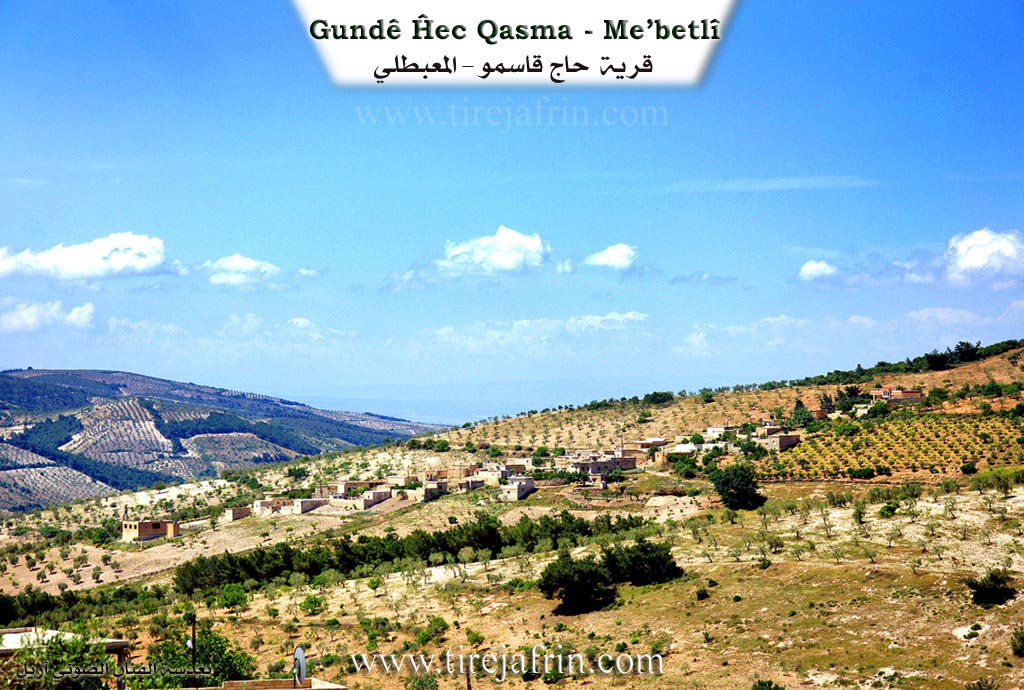
The village of Hecqasma is affiliated with the Mebeta district of the Efrîn canton. It is located 12 km west of the town of Mabeta and 30 km northwest of the city of Efrîn.
The name of the village of Hecqasma comes from the name of the village's founder, ((Heciyê Qêsim). As is known, Heciyê Qêsim initially settled in the village of Sîngankê in the Cindirêsê district, and later moved to the Xastiyan mountain to make charcoal and cut poles, as the region
116
Xastiyan was famous for its oak and terebinth forests, and thus the village of Hecqasma was founded.
The village of Hecqasma was formed from a mosaic, therefore 12 families live in the village:
The family of Ûsê, Umê, Hemê, Xelê, Extiyêr, Henanê Ebdo, who are all from one family, meaning they are Hecqasmî; the families of Êho, Bozo, who are originally from the village of Dela; the family of Ûreş, Meyrê, Kurtancî, and the family of Hemûşê, who are originally from the village of Misteşûra.
It is worth mentioning that a Hecqasmî family named Soro has settled in the town of Şiyê. There is a street named Hecqasma street in the village of Be’dîna.
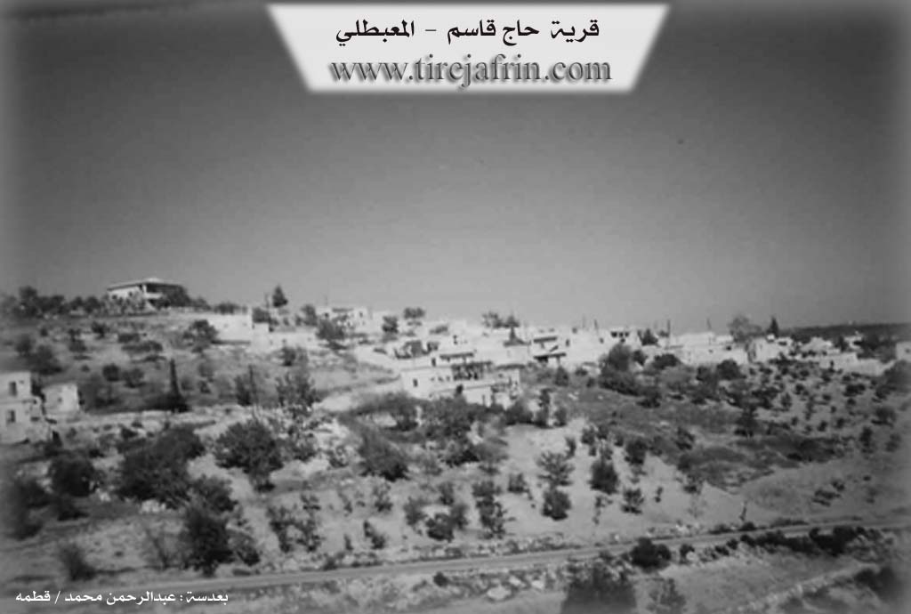
The village of Hecqasma is the oldest of the surrounding villages. It was built at the base of the mountain on the east side, in a high place, meaning it faces the sunrise.
To the east of the village are the Hecqasma spring and the village of Misteşûra. To the south are the Dolê valley, or Circim, and the villages of Kaxrê and Rûta. To the west are the Komrik valley, Serê Qûça, and the village of Dela. To the north are Serê Gazê and Baniya Ozê.
The village of Hecqasma is mountainous, and the surrounding mountains are adorned with oak forests. Among them are the Çizîrka mountain to the south, and the Umê, Extiyêr, Heydo, Binê Hêra, and Çatê mountains. All the forests have made the region a place of travel and recreation with their pleasant breezes and magnificent and sweet scenery.
117
The Dolê valley, or Circim, is at the base of the village. It is adorned like a plain with fruit fields and vegetable gardens. People from distant places visit it on holidays and spend their time with joy and happiness.
Because the village is ancient, there are many caves in the village that people used as houses, but now they are used as places for livestock or as household storage.
Nearly 85 houses and more than 1200 people live in the village; all the people of the village have good relations. In celebrations and sorrows, they act together as one family.
The people of the village, like all the villages of the region, make their living from agriculture, primarily from the cultivation of olive and grape fields. The village is also famous for its walnut and sumac trees. Along with them, some families also own livestock such as sheep and goats. A number of people from the village work as merchants in the markets of Efrîn, Çindirêsê, Reco, and Mabeta. Nearly 15 people also work in the institutions and agencies of the Autonomous Administration in Efrîn and Mabeta.
The village headman, Heydo, is one of the famous people in the village of Hecqasma and had served as headman for nearly 40 years and provided many services to the village.
118
Ezîzê Umê was a well-known and famous social figure. He was loved and known among the people.
Mistê Bozo was one of the scholars of the Islamic religion, and he did considerable work in this field.
Henanê Meyrê and Evdê Êho were rebel soldiers with the famous and renowned Mihê Îbşaşo, and they participated in many wars and battles against the French occupation.
The primary school teacher, Mihemed Heso, did a lot of work in the field of public service for the village, such as bringing electricity, building a modern school, and repairing the main road of the village. But unfortunately, he lost his life in a sad incident in 2012 on the Efrîn–Heleb road by a sniper's bullet.
Transcriptions and Subtitles
| Source | Video | Subtitles | Transcript |
|---|---|---|---|
| Afrin 366 1 | Watch Video | Download SRT | View Transcript |
| Ax û Welat 1 | Watch Video | Download SRT | View Transcript |
Foundation/Origin Information of Ĥec Qasma
The Haj Qasim family was the first to live in the village.
Source: TirejAfrin Site
The village traces its origins to the Bîa tribe, who migrated from Dersim. They passed through several locations before settling at the current site due to land disputes. The community is structured around three original families: Mala Emê, Mala Extîr, and Mala Yûsê.
Source: Ax û Walat Transcript
Possible Village Name Meaning of Ĥec Qasma
Qasim is a local proper name of its first inhabitant, and "Haj" is his religious title.
Source: TirejAfrin Site
The village is named after its founder, Hecî Qasim Hecî.
Source: Ax û Walat Transcript