General Information
Nahiya (Subdistrict)
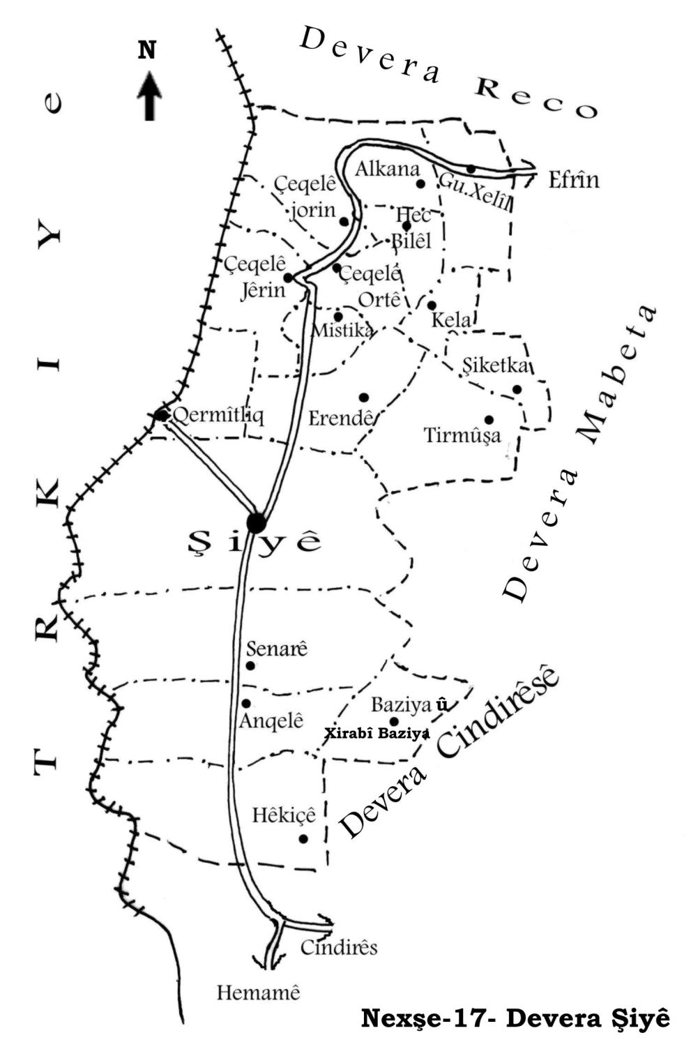
Şiyê
Also Known As
Anqela, Anqelê, Anqelê û Xirabê Anqelê, آنقله, أنقلة وخربة آنقله, انقله
Families, Clans, etc.
Elî Remedên, Gundî Hisê, Mala Eliyê axa, Mala Elîkê, Mala Mehmkê, Mala Mistehciyê, Mala Se'dûn, Mala Xelû, Mala me, Mala Îmir, Malê Ehmed Axa, Malê Hemxêrê, Malê Reşîd, Malê Tilyatê, Malê Xwêcelêra
Photos
Basic Information about Anqelê
Source: Ax û Welat (Information for Anqelê and Senarê)
Etymology: Senarê is named after a village in Bakurê Kurdistan; Anqelê may mean Kela Dayikê (Mother's Castle) or derive from the Turkish On Kale (Ten Castles)
Foundation Date/Period: Senarê was founded 500 years ago; Anqelê was founded 400 years ago
Caves: Şikefta Tilê Cirnasê
Number of Caves: 300
Springs: Kaniya Senarê, Kaniya mezin, Kaniya Baziyê
Hills: Til Carnas, Tilê Cirnasê, Çiyayê Cirnasê
Shrines: Qiracê Rehve
Ruins: Xirabê 'Etarê, Qereş, Qesra Padîşah
Wells: Bîra Romanî, Gola Hovo
Other Landmarks: Geliyê Curcum, Curcumê mezin, Curcumê çûçik
Summaries
I. Summary from TirejAfrin Site (English) of Anqelê
Source: https://www.tirejafrin.com/site/kura%20afrin%20%20%20shiye%20-%20anqele.htm
The following is stated in the book جبل الكرد (عفرين) دراسة جغرافية Çiyayê Kurmênc (Efrîn): A Geographical Study by د. محمد عبدو علي Dr. Mihemed Ebdo Elî:
Anqelê, Anqelê /2037 inhabitants - 6km - 360m/:
I believe the situation of this village's name is similar to the aforementioned village of Senarê. Or, it is a compound of two names: an = mother in Kurdish, and qele = which is a distortion of the name castle, meaning the "Mother Castle." There are ancient ruins at the site and its vicinity.
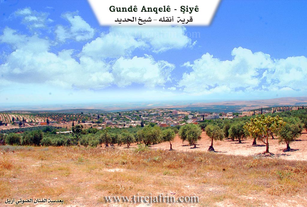
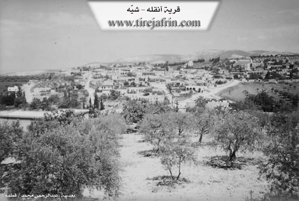
It is a large village located on a limestone plateau. To its east is the site of "Xeraba Anqelê" (Ruins of Anqelê) /350m/, which its inhabitants abandoned in the early twentieth century.
The following is stated in the book عفرين .... نهرها وروابيها الخضراء Efrîn... Her River and Her Green Hills by the writer عبدالرحمن محمد Ebdulrehman Mihemed from the village of Qetme:
Anqelê: A village in Çiyayê Kurmênc, following the Şiyê sub-district, Efrîn region, Heleb governorate. It is a large village located on the western slope of Çiyayê Kurmênc atop limestone soil suitable for agriculture. It is approximately 3.5 km south of the Şiyê sub-district center.
It is bordered to the north by the nearby village of Senarê; to the south by a mountainous height planted with olive trees and the village of Hêkicê; to the east by a high mountain chain, a deep valley called Geliyê Cercem, and the villages of Bazyanlî and Hac Hesenlî; and to the west by a wide plain planted with olive trees, the Turkish borders, and Liwa Skenderûn directly.
Its lands are limestone, mountainous and sloping, becoming plain-like on the western side up to the Turkish border, and mountainous on the northeastern side. The number of its houses is approximately 125, and its age is about 400 years. Its old dwellings are of stone and mud with wooden roofs, while the modern ones are of stone and cement.
An electricity network is available, as well as drinking water from the well of the town of Şiyê (Senarê) via a modern water network. There is a primary and preparatory school in the village. It is connected to the sub-district and neighboring villages by a paved road passing through its center, coming from the town of Cindirês up to the town of Şiyê.
The village contains a clinic and a rural agricultural development unit. The residents work in rain-fed agriculture on an area of /765/ hectares (olives, grains, figs) and irrigated agriculture on an area of hectares (apricots, pomegranates, summer vegetables), alongside raising sheep and goats. There are three olive presses in the village. The village belongs to the Senarê municipality. The farm of Xeraba Anqelê is attached to it.
Village Mukhtar: Kemal Se'do
Sources:
- Book: جبل الكرد (عفرين) دراسة جغرافية Çiyayê Kurmênc (Efrîn): A Geographical Study by د. محمد عبدو علي Dr. Mihemed Ebdo Elî.
- Book: عفرين .... نهرها وروابيها الخضراء Efrîn... Her River and Her Green Hills by عبدالرحمن محمد Ebdulrehman Mihemed from the village of Qetme.
Preparation and execution:
- Manager of Tirej Efrîn site: Ebdulrehman Hacî Osman
- 20/12/2013
II. Summary of Anqelê and Senarê from Ax û Welat
Source: https://www.youtube.com/watch?v=42pma_QaQeg
The villages of Senarê and Anqelê, located in the Şiyê region, share a deep historical and social bond, having originated from a common settlement process. Senarê was founded approximately 500 years ago, while Anqelê followed about a century later. The history of Senarê begins with Mistê Hecî, who migrated from a village also named Senarê in Bakurê Kurdistanê. He initially settled at a location known as Xirabê 'Etarê, where the Malê Hemxêrê and Malê Xwêcelêra families were present. Eventually, the community established the current village of Senarê. The name Anqelê has contested origins. Elders suggest it may mean Kela Dayikê (Mother's Castle) or relate to a Turkish description On Kale (Ten Castles), referring to the many fortifications that once existed there.
Before these current villages existed, the area was dominated by an ancient settlement at Til Carnas, a hill that holds significant archaeological value. Elders describe Til Carnas as a place of legends, mentioning a Padîşah named Cirnas who had a palace, Qesra Padîşah, atop the hill. The site is said to contain 300 wells, cisterns, and caves, though many are now covered. The area around Til Carnas and the nearby Qiracê Rehve served as a necropolis with many tombs. The region historically had no hard borders; residents freely traded and arranged marriages in Kilis, Îskenderûn, Entakê, and Qirixxanê, with Heleb being virtually unknown to them until political boundaries shifted.
The social structure is defined by several prominent families. The Mala Mistehciyê (descendants of Mistê Hecî) are central to the history of Senarê. Other notable lineages across the two villages include Malê Xwêcelêra, Malê Reşîd, Mala Elîkê, Mala Îmir, Mala Se'dûn, Mala Eliyê axa, and Mala Mehmkê. The Mala Xelû family is specifically renowned for their olive cultivation, producing the distinct Zeytûnê Xelû variety.
Water has always been a critical resource for these communities. The Geliyê Curcum valley contains the vital Kaniya Senarê (also called Kaniya mezin) and Kaniya Baziyê. Historically, seven mills operated along this water source. When the springs would dry up, the villagers relied on an ancient Bîra Romanî (Roman Well) located about two kilometers away. The documentary also highlights local craftsmanship, featuring a carpenter named Omer who crafts the Tenbûr instrument from mulberry, apricot, and almond wood, inspired by musicians like Mihemedê Elî Tijo and Cemîl Horo.
Transcriptions and Subtitles
| Source | Video | Subtitles | Transcript |
|---|---|---|---|
| Ax û Welat 1 | Watch Video | Not Available | View Transcript |
Foundation/Origin Information of Anqelê
Next to it to the east is the site "Khirbet Anqela" (خربة آنقلة), whose inhabitants emigrated in the early twentieth century.
Source: TirejAfrin Site
Possible Village Name Meaning of Anqelê
Composed of two names: An = mother in Kurdish, and Qala = which is a corruption of the name fortress, meaning the mother's fortress.
Source: TirejAfrin Site