General Information
Nahiya (Subdistrict)
Efrîn
Also Known As
Aqiba, Aqîbê, عقيبة
Families, Clans, etc.
Dembilaxî, Hebeş, Hecvirîmo, Malê 'Emmo, Malê Felleh, Malê Xidir, Mile, Misrî, Mistûka, Mlan, Omer, Çîlo, Îbîş, Şašo

Photos
Basic Information about Aqîbê
Source: Ax û Welat
Etymology: Derived from 'qoranîn' meaning 'dumahî' (end); or 'qîb'/'qinderîs' (a type of thorn); or 'belekiyan' (a high layer/elevation); or from Eqîbe modified by the Arabic letter 'Eyn'
Foundation Date/Period: Current site founded approximately 350 years ago; ancient habitation dates back 5000 to 6000 years
Caves: Şikeftên Aqîbê
Number of Caves: 10
Hills: Çiyayê Lêlûn, Kelak Cûcik
Ruins: Qesra Melîk, Kelê, Hazleft, Mehsere
Wells: Jurna Avê
Other Landmarks: Dibistana Aqîbê, Gola Zeytê
Summaries
I. Summary from TirejAfrin Site (English) of Aqîbê
Source: https://www.tirejafrin.com/site/kura%20afrin%20markaz-aqiba.htm
In the book جبل الكرد (عفرين) دراسة جغرافية Çiyayê Kurmênc (Efrîn): A Geographical Study by د. محمد عبدو علي Dr. Mihemed Ebdo Elî, the following is stated regarding Aqîbê: /3184 inhabitants, 35 km, 505 m/:
The village derived its name from the shrine of Şêx Eqîb located within its cemetery.
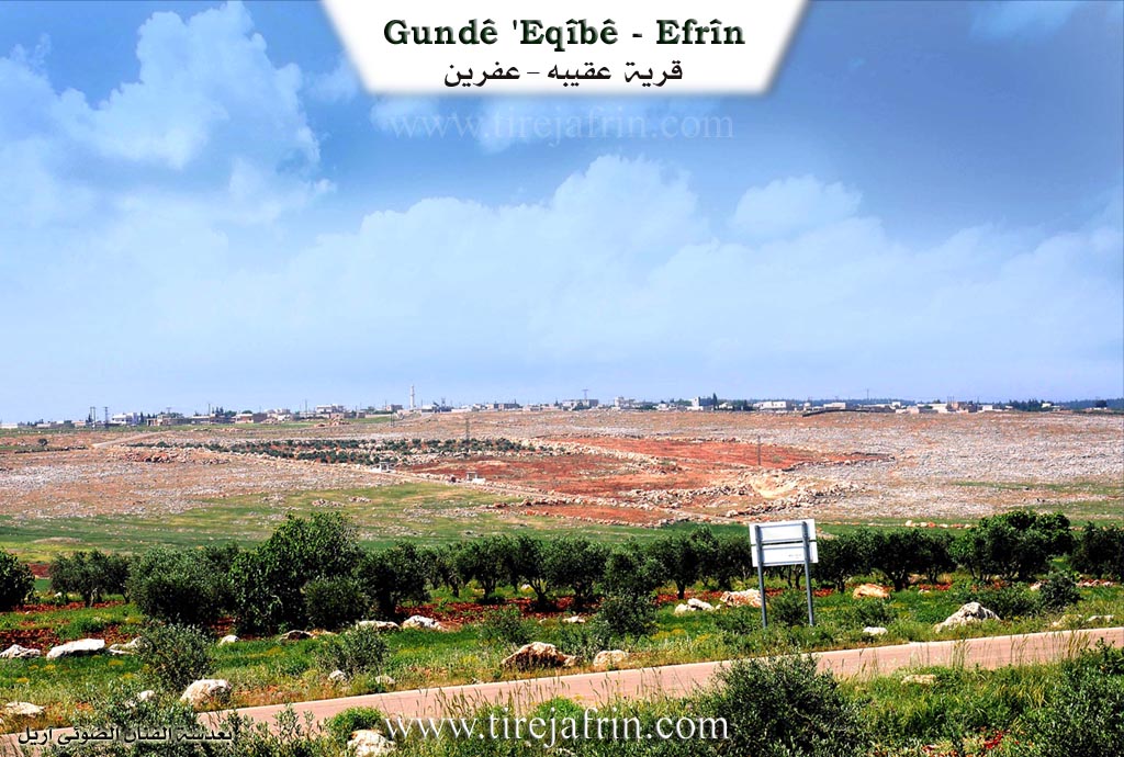
It is a large village situated in the middle of an undulating plain of clay soil where cereals and olives are cultivated.
In the book عفرين .... نهرها وروابيها الخضراء Efrîn... Her River and Her Green Hills by the writer عبدالرحمن محمد Ebdulrehman Mihemed from the village of Qetme, it is stated:
Aqîbê: A village in Çiyayê Lêlûn, administratively attached to the subdistrict of villages of the center and area of Efrîn, Heleb governorate. It is a large village located atop the summit of a limestone plateau east of Çiyayê Lêlûn in the central part of the mentioned mountain. Its slopes are furrowed by watercourses descending in all directions. It is located to the southeast of the city of Efrîn at a distance of 25 km. Its soil is fertile clay.
It is bordered to the north by a mountain chain of rocks and the village of Basilhaya and Cilbil; to the south by a mountain chain of rocks and forest trees, the ruins of Qunêtra, and the village of Meyasa; to the east by a mountain slope, the village of Cetal Ziyaret, and Xirbet Heyat; and to the west by a rugged mountain chain of rocks and forest trees and the village of Soxanek.
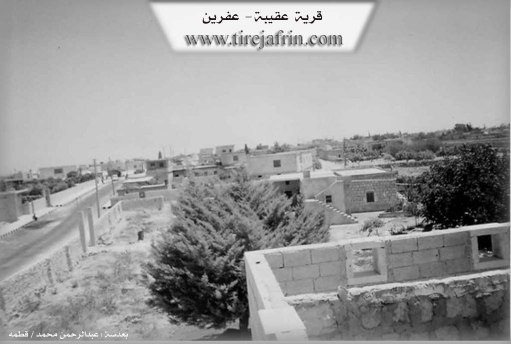
The number of its houses reaches about 200 houses, and its age is about 500 years. Its old houses are of stone and mud with flat wooden roofs, and a few of them are domes, while the modern ones are of stones and reinforced concrete.
Available services include an electricity network, a water network (derived from the artesian well dug southeast of the village), a telephone network, and primary, middle, and high schools. A municipality was recently established in it, to which the following villages follow: (Ziyaret, Xirbet Heyat, Soxanek).
Its residents cultivate rainfed crops on an area of 678 hectares, including cereals, grapevines, and olive trees, alongside raising sheep, cows, and goats. It connects eastward with the Riya Heleb-Ezaz-Efrîn (Heleb Ezaz Efrîn road) via a paved branch road.
Village Mukhtar: Hesen Yûsif
Sources
Book: جبل الكرد (عفرين) دراسة جغرافية Çiyayê Kurmênc (Efrîn): A Geographical Study by د. محمد عبدو علي Dr. Mihemed Ebdo Elî.
Book: عفرين .... نهرها وروابيها الخضراء Efrîn... Her River and Her Green Hills by عبدالرحمن محمد Ebdulrehman Mihemed from the village of Qetme.
Preparation and execution:
Manager of Navenda Tirej Efrîn: Ebdulrehman Hacî Osman
20/12/2013
II. Summary of Aqîbê from Ax û Welat
Source: https://www.youtube.com/watch?v=PyfIS4IxG6U
The village of Aqîbê, located in the Şêrawa district of the Efrîn region, stands as a settlement with deep historical roots and a strong reputation for education and resistance. Situated on the border between Efrîn and Heleb, specifically on the slopes of Çiyayê Lêlûn (also known as the Mountain of Olives), the village has a population of approximately 400 households. The name Aqîbê has several proposed origins, ranging from the word for a local thorn known as 'qîb' or 'qinderîs', to a term meaning 'end' or 'conclusion', referring to its location as the last village in the Şêrawa district.
The history of Aqîbê is divided between its ancient origins and its modern foundation. Villagers recount that the area has been inhabited for 5,000 to 6,000 years, pointing to ancient ruins such as Kelak Cûcik and Qesra Melîk (The King's Palace). Elders speak of a time when a tunnel connected Qesra Melîk to the Kelê citadel, used by a figure known as Melîk Xûdanê Bajêr. However, the modern village was established roughly 350 years ago. Before this move, the ancestors of the current residents lived in a cluster of ten caves nearby, known as Şikeftên Aqîbê. These caves, which contain stone carved beds and water troughs like Jurna Avê, were home to ancient families such as Mile, Dembilaxî, Şašo, Misrî, and Çîlo.
The social structure of the modern village is defined by specific lineages. The core population descends from four brothers who established the families of Îbîş, Hecvirîmo, Mistûka, and Hebeş. Later arrivals included Malê Xidir and Malê 'Emmo (also known as Malê Felleh). Notably, Malê 'Emmo were originally of Arab descent but have culturally assimilated over 150 years, now speaking Kurmanji and identifying with the community. Other families mentioned include Mlan and Omer.
Aqîbê is renowned throughout the region for its emphasis on education. It was the site of the first school in Şêrawa, Dibistana Aqîbê, founded in 1948. This school served students from many surrounding villages, including Kîmarê, Basûtê, Bênê, Xirêbkê, and Ziyaretê. Because of this early educational infrastructure, the village boasts over 400 university graduates, including many doctors and lawyers.
Culturally, the village preserves traditions related to olive oil production, evidenced by an ancient press called Mehsere and the Gola Zeytê (oil pit). Women in the village are known for weaving carpets called 'Perde' using a tool called a Kerkit. In recent years, Aqîbê has become a frontline position. The residents, including women who organize daily cooking rotations for fighters, actively support the defense of the village against attacks. The village also honors the memory of Şehîd Mahsûm, an artist who created intricate wood carvings while imprisoned before losing his life in the conflict.
Transcriptions and Subtitles
| Source | Video | Subtitles | Transcript |
|---|---|---|---|
| Ax û Welat 1 | Watch Video | Not Available | View Transcript |
Foundation/Origin Information of Aqîbê
According to oral tradition, the community originally lived in a settlement of ten interconnected natural caves before relocating to the current site approximately 350 years ago, a settlement that began with just two houses.
Source: Ax û Walat Transcript
Possible Village Name Meaning of Aqîbê
The village derived its name from the shrine of Sheikh Aqib located within its cemetery.
Source: TirejAfrin Site
The name "Aqîbê" itself has several proposed origins, possibly deriving from the Kurdish word "Aqîb" (the end), "Qîb" (a type of thorn or the name of a local hill), or through a linguistic evolution involving the Arabic letter 'Ayn'.
Source: Ax û Walat Transcript