General Information
Nahiya (Subdistrict)
Şera
Also Known As
Ali Bazan, Ali Bazanli, Be'rafo, Be'rava, Berava, بعرافو, علي بازان, علي بازانلي
Tribes
Barafî
Families, Clans, etc.
Alî Welî, Dînik, Ehmedê Şêx, Hec Bekria, Hecî Arif, Koşê, Mist Xelîl, Nesîb, Qençû, Reşê, Reşîtê Vebecê, Sefer, Seydê Simo, Tirk Arif, Çawîş, Çawîşxûla, Şêx Hemê

Photos
Basic Information about Be'rava
Source: Ax û Welat
Etymology: Berava (meaning 'Beside the water/river'); Arabized as Be'rava
Foundation Date/Period: Approximately 300 years ago
Caves: Mala Ehmedê Şêx, Mala Sefer, Hecî Arif, Mala Nesîb
Number of Caves: 6
Springs: Mologiyê
Hills: Wagûd
Ruins: Wagûd
Other Landmarks: Gelyê Sîmanê, Ardê Qose, Meydankê
Summaries
I. Summary from TirejAfrin Site (English) of Be'rava
Source: https://www.tirejafrin.com/site/kura%20afrin%20%20sheran%20-%20bar%20avo.htm
It is stated in the book Çiyayê Kurmênc (Efrîn): A Geographical Study: Be'rava, Elî Bazan, Elî Bazanlî /719 people, 6km, 390m/:
Be'rava: It is believed that the origin of its name is from Ber ava, meaning beside the water (ber + ava), as the village is located on the shoulder of the Efrîn river. It is also the name of a Kurdish tribal group found in South Kurdistan and in the city of Damascus, including Ehmedê Barafî, the known Kurdish Damascene fighter during the French Mandate.
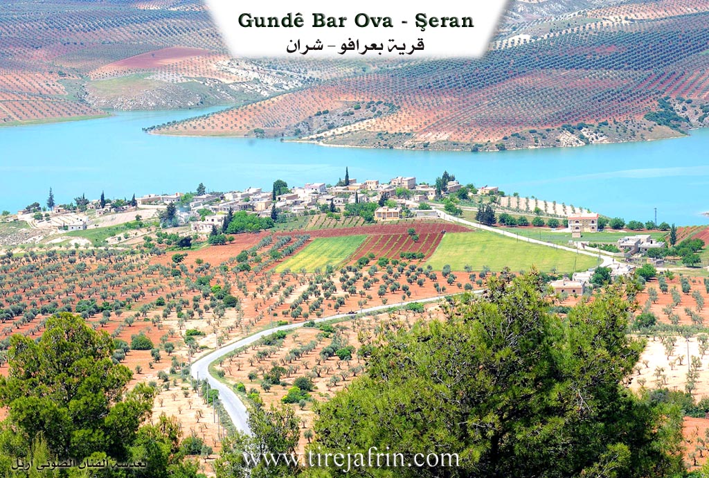
It is a medium-sized village overlooking the Meydankê lake to the west. East of the village, there is an archaeological site containing tombs and large multi-room dwellings carved into the rock. The waters of Meydankê lake have reached its western limits.
It is stated in the book Efrîn... Her River and Her Green Hills: Elî Bazan, Be'ravav: A village in Çiyayê Kurmênc belonging to the Şera district, Efrîn region, Aleppo governorate (699 inhabitants). It is a small village located on the western slope of the northeastern part of the mentioned mountain. It overlooks the valley of the Efrîn river to the west from an elevated position atop a limestone flat, covered by clay-limestone soil.
It is 4km away from the town of Şera towards the northwest. It is bordered on the north by a slope and the course of the Efrîn river a few meters away, the village of Meydankê, and the village of Qarqîna Piçûk; on the south by a valley, a plain, a mountain range planted with olive and forest trees, and the village of Kûbelek; on the east by a slope, a deep valley, the village of Qarqîna Mezin, and the village of Cemanlî; and on the west by the Efrîn river, a plain planted with olive trees, and the town of Meydankê.
The number of its houses is 35, and its age is approximately 500 years. It is one of the old villages adjacent to the river. The settlement of the area is very ancient, indicated by the presence of an archaeological hill in the west of the village comprising tombs and large multi-room dwellings carved into the rock. Its old houses are made of stone and mud with wooden roofs, while the modern ones are concrete. An electricity network is available. The village drinks from a water network connected to a well dug south of the village of Cemanlî. It is connected to the district center by a newly paved road, and it has a primary school.
The residents of the village work in the cultivation of olives and irrigated vegetables on an area of 943 hectares due to its proximity to the Efrîn river. They also raise sheep and goats. Among its most important families is the Çawîş family, who are among its original inhabitants.
Village Mukhtar: Elî Mihemed Ebdo
Sources of Information:
- Book: جبل الكرد (عفرين) دراسة جغرافية Çiyayê Kurmênc (Efrîn): A Geographical Study by د. محمد عبدو علي Dr. Mihemed Ebdo Elî.
- Book: عفرين .... نهرها وروابيها الخضراء Efrîn... Her River and Her Green Hills by عبدالرحمن محمد Ebdulrehman Mihemed from the village of Qetme.
- Studies of Navenda Tirej Soft / Ebdulrehman Hacî Osman.
- Some residents of the villages.
Preparation and execution: Manager of Tirej Efrîn site: Ebdulrehman Hacî Osman 20/12/2013
II. Summary of Be'rava from Ax û Welat
Source: https://www.youtube.com/watch?v=B-SmuOYzUpg
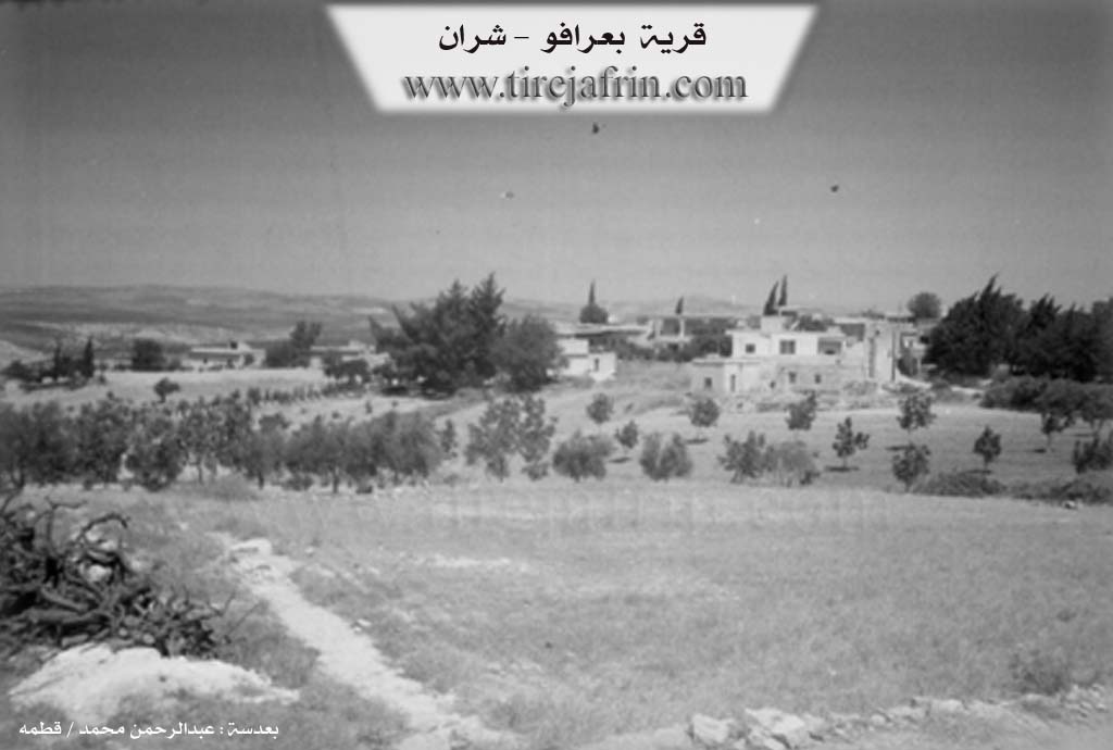
Located in the Şera district north of Efrîn, the village of Berava (locally known as Be'rava) sits in the shadow of the Derhûle mountains, overlooking the Meydankê lake. The village name translates to "Beside the Water," referencing its proximity to the Afrin river. While the name was Arabized to Be'rava (adding the guttural 'ayn') during previous eras of state centralization, residents emphasize the original Kurdish meaning, Berava. The village was founded approximately 300 years ago. According to the elder Bavê Emîn, the original settlement was located closer to the water before moving to its current position. The first family to settle there was the Koşê family.
The social structure of Berava consists of roughly 100 households comprising various families, including Mist Xelîl, Çawîşxûla, Seydê Simo, Hec Bekria, Alî Welî, Qençû, Reşê, Reşîtê Vebecê, Şêx Hemê, Dînik, and Tirk Arif. The village has a strong educational history; a primary school was established in 1951, serving not only Berava but also neighboring villages such as Qerqîna, Çema, Derwîş, and Gobelekê. Prior to the school's construction, children received religious education from Mullahs, such as the late Şêx Elî from Qerqîna.
Significant landmarks shape the village's geography and history. A lush valley known as Gelyê Sîmanê lies between Berava, Umera, Çema, and Qerqîna. Its name, Sîman, derives from the abundance of shade ("sî") provided by its dense trees. The area contains old cisterns and was historically a site for orchards. To the west lies an area called Wagûd, which contains ruins and cisterns, indicating ancient habitation where people once lived in rock-cut dwellings.
Local historian Apê Remezan notes that there are six distinct caves in the vicinity, some of which were inhabited by villagers and their livestock before modern houses were built. These include caves named after specific families or individuals, such as Mala Ehmedê Şêx, Mala Sefer, Hecî Arif (located at Ardê Qose), and Mala Nesîb.
Economically, the village relies heavily on olive cultivation, producing varieties such as Zeytî, Xelxalî, and Sûranî. However, the construction of the Meydankê dam by the Syrian regime led to the submersion of significant agricultural land and ancestral olive groves. Culturally, Berava maintains traditions of wheat processing using a circular grinding stone called a Delîb. The village is also known for its artistic contributions, having produced poets like Hîro and musicians like the renowned late dengbêj Silêmanê Çûçê, as well as contemporary artists like Mihemed Welîd, Nîdal Îso, and Şe'ban Be'ravî. Residents like Heyat continue to preserve traditional Kurdish handicrafts, creating dowry items adorned with Kurdish symbols and colors.
Transcriptions and Subtitles
| Source | Video | Subtitles | Transcript |
|---|---|---|---|
| Ax û Welat 1 | Watch Video | Download SRT | View Transcript |
Foundation/Origin Information of Be'rava
Among its most important families is the Jawish family, who are among the original inhabitants.
Source: TirejAfrin Site
Possible Village Name Meaning of Be'rava
It is believed that the origin of its name comes from Ber ava meaning "beside the water." It is also the name of a Kurdish tribal group.
Source: TirejAfrin Site
Its name means "by the water," reflecting its historical proximity to the Afrin River and numerous springs.
Source: Ax û Walat Transcript