General Information
Nahiya (Subdistrict)
Efrîn
Also Known As
Bai, Baiye, Bi'îyê, Buhyê, باعي, بعيه, Ba'i
Families, Clans, etc.
Behrî, Berkatê Xerîb, Elûşê Elî Hesen, Kolkî, Mala Nabo, Mala Nasirdîn, Mala Şêx Mend, Mehmûd, Misto, Omerê Elûş, Qerehesokê, Şêxo Nebo

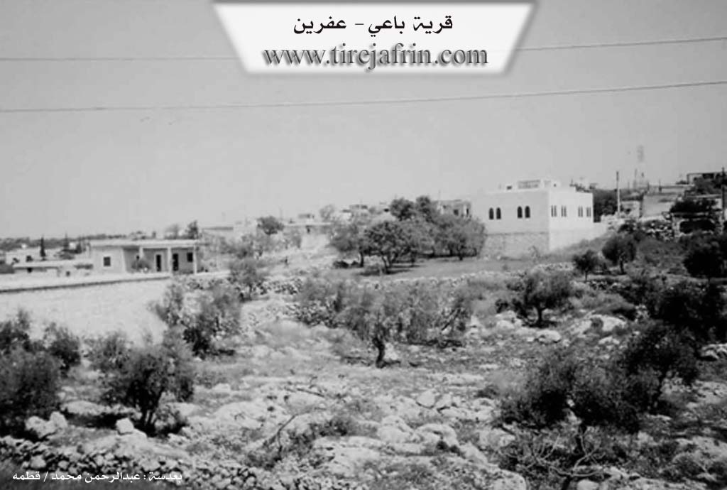
Photos
Basic Information about Bi'îyê
Source: Tirej Afrin
Etymology: Kurdish name for a type of wild tree
Foundation Date/Period: 500 years
Hills: Çiyayê Lêlûn, Çiyayê Simean, Zihir el-Kebîr
Summaries
I. Summary from TirejAfrin Site (English) of Bi'îyê
Source: https://www.tirejafrin.com/site/kura%20afrin%20markaz-baiye.htm
Based on the book جبل الكرد (عفرين) دراسة جغرافية Çiyayê Kurmênc (Efrîn): A Geographical Study by د. محمد عبدو علي Dr. Mihemed Ebdo Elî:
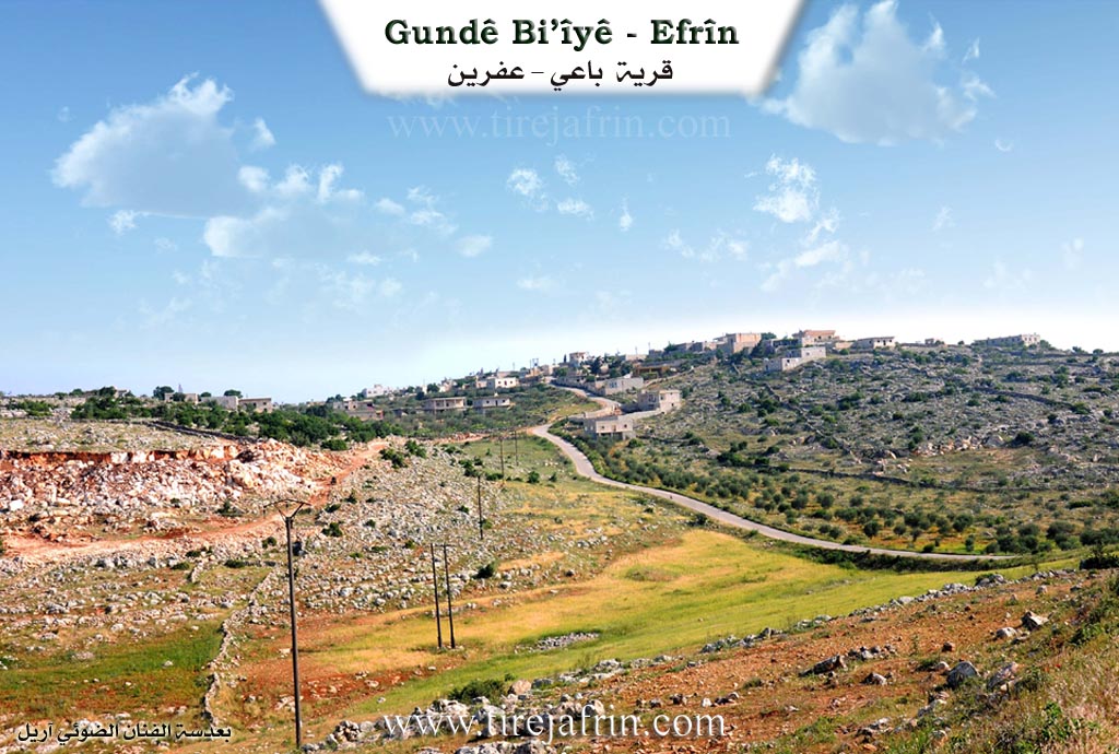
Baê, Baê /878 people, 195 houses, 600m altitude/:
It is a Kurdish name for a type of wild tree. It is located approximately 2km north of the village of Basûfan. Beside it are ruins, tombs, and wells carved into the rock dating back to the Roman era.
Based on the book عفرين .... نهرها وروابيها الخضراء Efrîn... Her River and Her Green Hills by the writer عبدالرحمن محمد Ebdulrehman Mihemed from the village of Qetme:
The village of Baê is a village in Çiyayê Lêlûn and Simean, administratively following the villages of the Efrîn center sub district and region, Heleb governorate. It is a large village located southeast of Efrîn, situated atop a rocky plateau on one of the peaks of the limestone Zihir el-Kebîr mountain, overlooking the Efrîn valley plain situated to its northwest.
It is bordered to the north by a rugged mountain range of rocks, two watercourses, and the villages of Kîmar and Beradê; to the south by the Simean mountain range, a slope, and the village of Basûfan; to the west by a mountain range, a slope at the bottom of the Efrîn valley, and the villages of Cûmê and Ghazawiya; and to the east by a rugged mountain range of rocks and the villages of Burc Heyder and Kefer Nabû.
The settlement of the area is ancient, as we find south of the village hewn stones, scattered limestone rocks, tombs, and wells carved into the rock dating back to the Roman era. The number of its houses reaches about 100 houses, and its age is 500 years. Its dwellings are old, made of mud and wood, while the modern ones are stone and reinforced concrete.
An electricity network is available, as well as a modern primary school located on the eastern side of the village and a modern mosque on the western side. The source of drinking water is pools, rainwater collection, and cisterns. The village connects with the village of Basûfan via a paved dirt road. The residents of the village work in the cultivation of cereals and olives on an area of 195 hectares, alongside raising livestock and cattle.
Village Mukhtar: Cemal Mistû Behrî
Preparation and Execution:
Manager of Tirej Efrîn site: Ebdulrehman Hacî Osman
20/12/2013
Sources:
- Book: جبل الكرد (عفرين) دراسة جغرافية Çiyayê Kurmênc (Efrîn): A Geographical Study by د. محمد عبدو علي Dr. Mihemed Ebdo Elî.
- Book: عفرين .... نهرها وروابيها الخضراء Efrîn... Her River and Her Green Hills by عبدالرحمن محمد Ebdulrehman Mihemed from the village of Qetme.
- Studies of Navenda Tirej Soft / Ebdulrehman Hacî Osman.
II. Summary of Bi'îyê from Afrin 366
Source: https://www.youtube.com/watch?v=PrnvywiQJP4
The documentary captures a detailed journey to the village of Ba'îyê, located in the scenic Efrîn region. The filming crew travels there after completing a video project in the neighboring village of Basûfanê. Their visit to Ba'îyê was specially requested by Cûzêf, a native of the village who now lives in the diaspora in Almanya, so that he and other expatriates could reconnect with their ancestral homeland through the footage.
As they drive into the Şêrewa district, the presenters marvel at the mountainous geography and the extensive agricultural landscape. A local resident explains that the village is remarkably large, containing approximately five hundred to six hundred households. The community sustains itself primarily through farming, cultivating wheat, barley, and abundant olive orchards. When asked about the prominent lineages, the resident notes that the village is most famous for the Omerê Elûş family. During their walk through the residential areas, the crew also points out the homes of other families and relatives, including the Kolkî family and the household of the late Behrî. They also pass by the property of a relative named Emar and call out briefly to someone named Ebdû.
The hosts continuously emphasize the strong emotional ties that people living abroad maintain with their birthplace. They film specific courtyards, large mulberry trees, and old rock structures specifically to evoke childhood memories for the viewers. The crew highlights how returning villagers from Almanya have built impressive new homes and brought essential modern infrastructure like electricity to the village. The camera captures an old ruined building that used to serve as a hospital. In one of the newly renovated courtyards, they are shown a deep water well that draws water from one hundred and twenty five meters underground.
The village retains a rich and vibrant pastoral life, with flocks of sheep, cattle, and diverse plant life appearing throughout the recording. The presenters are particularly fascinated by a unique thorny plant bearing a mix of white, red, and yellow blossoms. They engage warmly with the local children, asking them about their aspirations, and the children proudly express their desire to attend school and become teachers. The older generation exchanges profound blessings with the crew, showcasing the deep hospitality characteristic of the locals.
Despite encountering rough and unpaved roads along the route, the documentary team remains captivated by the pristine environment. Toward the end of the recording, as the afternoon approaches and the crew prepares to depart, they direct the camera toward the striking natural caves embedded in the rocky terrain just outside the village. The video ultimately serves as a heartfelt tribute, bridging the distance for those separated from their cherished community of Ba'îyê.
II. Summary of Bi'îyê from Ax û Welat
Source: https://www.youtube.com/watch?v=yb_0Bh1IQ3w
The village of Bê'yê is located in the Şêrawa district of the Afrin region situated on the high elevations of Çiyayê Lêlûn. According to local elders its name derives from the Kurdish word for wind reflecting the strong gusts that sweep across the mountain. The Syrian regime later attempted to Arabize the name to Ba'î but the historical Kurdish identity remains intact.
The village was established approximately 150 to 200 years ago as an offshoot of the neighboring settlement of Basûfanê. The first person to settle the area was an Êzîdî individual followed shortly by a Misilman named Qerehesokê. Today the village comprises around 140 to 150 houses with a population of nearly 1000 people. It is defined by the deep social harmony between its Êzîdî and Misilman residents who often describe their ancient historical roots as Zerdeştî.
Several prominent families form the core of the community including Şêxo Nebo, Elûşê Elî Hesen, Misto, and Mehmûd. Historical migrations shaped this demographic with the Misto family having relocated from the border villages of Tofê and Sicê. The spiritual life of the Êzîdî population is guided by the Berkatê Xerîb family which serves as a sacred spiritual lineage alongside elders from Mala Nabo, Mala Şêx Mend, and Mala Nasirdîn.
Sacred sites hold great importance in the daily lives of the villagers. The Wesilqerar shrine previously known as Murasil Ereb or Risaleya is a site of deep reverence. In the center of the village stands the Hinarê shrine where residents gather on Friday evenings to light candles and offer sacrifices. Another vital spiritual location is Cemayê where Êzîdî families visit on Wednesdays for healing rituals believing that the intercession of the spiritual guides can cure sick children or ailments like blindness.
Daily life in the village has historically required great resilience. Since the village has no natural springs residents dug local wells or walked long distances at dawn to fetch water from Xezîwê. Agriculture remains the economic backbone relying on olive groves and the rearing of sheep and cows. Women prepare traditional winter provisions such as gulîlik and lork. The village also takes pride in its cultural preservation. For over forty years local tailor Elîf Mistefa has crafted traditional Afrin garments including the ezcêf dresses and merkezî headscarves. The community honors its fallen heroes naming the local commune after Şehîd Çekdar and the school after Şehîd Dilxwaz alongside commemorating other martyrs like Avesta, Serhat, and Zinar.
II. Ax û Walat Book 1
THE VILLAGE OF BUHYÊ
28.10.206
The village of Buhyê is affiliated with the Şêrewa district of Efrîn canton, located 22 km south of the city of Efrînê and 12 km south of the town of Basûtê.
The name of the village, as it is estimated, comes from the phrase (There is wind), because it was built on the height of the Lêlûn mountain and the wind of the area is strong.
The village of Buhyê was formerly a small village affiliated with the village of Basofanê, but later it grew and became a village on its own.
146
independent, so Buhyê is not ancient, meaning its age is no more than 150 years.
Xerîbê Nebokê, who was Êzdî, was the first person from the village of Basofanê to come and settle here. Later, Qere Heso, who was himself a Muslim from the village of Siciyê on the border, came and settled here.
In this way, the village of Buhyê is composed of two components, Êzdî and Muslim, and they all live in warm and good relations.
There are 4 families in the village:
The family of Xerîbê Nebokê, Elûş Hiso, Mehmûdê Qere Heso, and the family of Mistoyê Qere Heso.
About 140 houses and nearly 1000 people live in the village, from both Êzdî and Muslim components.
To the east of the village are the Xet valley, the ruin of Istonke, the village of Kefer Nebo, and the village of Birc Heyderê.
To the south are the Piling valley, the Sem’an Citadel, and the village of Basofanê.
To the west are the Asa valley and the village of Xezewê.
And to the north are the Qertel valley and the villages of Birc Ebdalo and Beradê.
147
The Qertel Valley is at the bottom of the village on the north side, and it contains many ancient caves.
The entire surroundings of the village are full of stones and rocks, which have left no place for agricultural fields.
The people of the village make their living by raising livestock such as goats, sheep, and cattle, and they sell their products in the markets of Efrînê. Agricultural work is scarce due to the lack of agricultural land, and only a few people work in the olive groves.
About 15 people work as employees in the institutions and bodies of the Autonomous Administration.
It is worth mentioning that the rate of emigration from the village is high due to economic reasons.
There are 4 martyrs from the village:
Martyr Çekdar, Avêsta, Serhat, and Martyr Zinar.
The village commune is named Ş. Çekdar, and the village school is named Ş. Dilxwaz.
Xerîbê Nebokê was a well-known religious figure of the Êzdî faith.
The Henarê shrine is in the middle of the village. On Friday evenings, the people of the village light candles and make sacrifices, and this tradition continues to this day.
148
Because the village of Buhyê is the last village in the Efrînê canton on the southern side, it faces many obstacles and shelling from the gangs, but they can never break the will of the village people.
Transcriptions and Subtitles
| Source | Video | Subtitles | Transcript |
|---|---|---|---|
| Afrin 366 1 | Watch Video | Download SRT | View Transcript |
| Ax û Welat 1 | Watch Video | Download SRT | View Transcript |
Possible Village Name Meaning of Bi'îyê
A Kurdish name for a type of wild tree.
Source: TirejAfrin Site