General Information
Nahiya (Subdistrict)
Efrîn
Also Known As
Deir Mashmash, Dêr Mişmiş, Dêrmişmiş, ديرمشمش
Families, Clans, etc.
Mala Elî Hemed, Mala Hemadî, Mala Hisên, Mala Merwan, Mala Mistefayê, Mala Osê Bahêj
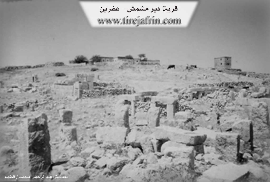
Photos
Basic Information about Dêrmişmiş
Source: Ax û Welat
Etymology: Dêr (Monastery) and Mişmiş (Apricot), or associated with Şems (Sun) and the Hurrian culture
Foundation Date/Period: Hurrian period
Number of Caves: 15
Springs: Kaniya Lêlûn
Hills: Çiyayê Lêlûn
Ruins: Birca Sor, Birca Spî, Birca Şêx Îsmaîl, Hêramok, Kela Şemsê
Other Landmarks: Geliyê Hemamê, Zeviyên Qelî, Zeviyên Hêrmok
Summaries
I. Summary from TirejAfrin Site (English) of Dêrmişmiş
Source: https://www.tirejafrin.com/site/kura%20afrin%20markaz-der%20mashmash.htm
It is stated in the book Çiyayê Kurmênc (Efrîn): A Geographical Study by Dr. Mihemed Ebdo Elî regarding Dêrmişmiş (520m altitude, 30km distance):
Dêrmişmiş: Perhaps "Mişmiş" was the name of the owner of a "Dêr" (monastery) that was there, or there were apricot trees (mişmiş) next to the monastery, so the site was named after them.
It is a wide archaeological ruin site which seems to have been a thriving city in ancient eras. It is located west of the village of Basilhaya by about 5km on Çiyayê Lêlûn. Its antiquities consist of the remains of church walls, a monastery, several buildings, a Roman tomb, gates to dozens of residential houses, a stone quarry, and box graves in the rock. All of these were constructed from huge trimmed limestone. In addition, there are cisterns dug into the rock, columns, lintels, presses, and scattered large trimmed stones dating back to the Roman and Byzantine eras. At the site, there are several residential houses belonging to seasonal shepherds from the village of Kurzêlê Çûmê. It is one of the sites that every person interested in archaeology must visit.
It is stated in the book Efrîn... Her River and Her Green Hills by the writer Ebdulrehman Mihemed from the village of Qetme:
Dêrmişmiş is a village in Çiyayê Lêlûn which follows the subdistrict of the center villages and the district of Efrîn, Heleb governorate. It is a small village consisting of only five houses located on the western Çiyayê Lêlûn chain and Çiyayê Sim'an. It is bordered to the north by a slope, a very deep valley, a rugged rocky mountain range, and the village of Xaldiye. To the south, it is bordered by a slope, a valley, a rocky mountain range, and the village of Soxane. To the east, it is bordered by a rocky mountain range and the villages of Basilhaya and Zerîqat. To the west, it is bordered by a rugged mountain range of rocks and valleys and the village of Kurzêlê at the bottom of the mountain.
The number of its houses amounts to only five houses, and the age of the village is approximately 150 years. There are some archaeological places within it dating back to the Roman and Byzantine eras, including the remains of a church in the north, a hermit's tower in the center of the village, remains of a church in the south of the village, several cisterns carved into the rock, remains of residential houses, and a monastery in the western direction. No services are available in the village except for the paved dirt road that reaches the village. The residents of the village work in cultivating grains and raising livestock and goats due to the rugged mountainous nature of the region.
Preparation and execution:
Manager of Tirej Efrîn website: Ebdulrehman Hacî Osman
20/12/2013
Sources:
- Book: جبل الكرد (عفرين) دراسة جغرافية Çiyayê Kurmênc (Efrîn): A Geographical Study by د. محمد عبدو علي Dr. Mihemed Ebdo Elî.
- Book: عفرين .... نهرها وروابيها الخضراء Efrîn... Her River and Her Green Hills by عبدالرحمن محمد Ebdulrehman Mihemed from the village of Qetme.
- Studies of Navenda Tirej Soft / Ebdulrehman Hacî Osman.
II. Summary of Dêrmişmiş from Ax û Welat
Source: https://www.youtube.com/watch?v=eI_8PyrBXbk
The village of Dêrmişmiş (also referred to as Dêr Mişmiş) is an ancient settlement located in the Şêrawa district of the Efrîn region. Situated on the slopes of Çiyayê Lêlûn, it lies approximately 12 kilometers from Basûtê and 22 kilometers southeast of the city of Efrîn. The name of the village is widely believed to be derived from the Kurdish words "Dêr" (Monastery) and "Mişmiş" (Apricot), referencing a historic monastery and the apricot trees that once enriched the area. However, local historian Mervan proposes a deeper etymological connection to the Hurrian word for "Sun" (Şems), linking the village to the nearby Kela Şemsê (Castle of the Sun) and the ancient sun-worshipping cultures of the region.
The history of Dêrmişmiş spans thousands of years, with roots in the Hurrian period, followed by distinct Roman, Byzantine, and Islamic eras. The village is an archaeological hub containing the ruins of a church, a theater, and a settlement known as Hêramok to the north. It is famous for its watchtowers (birc), specifically Birca Sor (Red Tower), Birca Spî (White Tower), and the Byzantine-era Birca Şêx Îsmaîl, which is estimated to be 1,400 years old. Another tower is dated to 1,800 years ago. The landscape is dotted with approximately 15 caves and numerous ancient wells that residents relied upon until recent times.
The social structure of Dêrmişmiş is defined by families who migrated to the site in more recent centuries. According to the elder Apê Hisên, the current population descends from three main families who arrived from the villages of Jilbir and Sûxanek. These include Mala Hemadî (also known as Mala Elî Hemed) and Mala Osê Bahêj (also known as Mala Hisên). Life in the village revolves around agriculture and livestock, particularly sheep herding. Residents like Fîdan describe a self-sufficient lifestyle, preparing traditional foods like şorba gilûk and preserving vegetables for winter. Shepherds such as Şefiq, Şiyar, and Agîd maintain a vibrant herding culture, crafting elaborate tassels (kejî) to decorate their flocks during the spring.
Dêrmişmiş preserves unique local traditions and healing practices. One prominent custom involves a "pierced stone" (kevrê qul). Villagers like Firyal recount how mothers pass children suffering from whooping cough through the stone's hole three times while reciting prayers to God for a cure. The village also remembers notable figures from its past, including traditional healers Hisênê Qaso and Mehmûdê Elî, the renowned singer Atûnê, and Şehîd Celal, a martyr after whom the local commune is named.
II. Ax û Walat Book 2
DÊR MIŞMIŞ
13.11.2017
The village of Dêr Mişmiş is an ancient village built on Lêlûn mountain, affiliated with the Şêrewa district of the Efrînê canton, 12 km from the town of Basûtê and 22 km southeast of the city of Efrînê.
The name of the village is composed of two words (Dêr – Mişmiş) due to the presence of an ancient monastery in the village and the village's wealth of apricot trees in past times.
Because the village is ancient, there are many ancient caves and wells there; there are nearly 15 caves, 40 wells, and five watchtowers in the village, known by the names of the Red Tower, the White Tower, etc.,
81
There are nearly 20 ancient presses, a monastery, and an ancient theater in the village.
The village of Dêr Mişmiş is famous for its abundance of archaeological sites, which date back to the Hurrian period, and also Zoroastrian symbols are a sign of this truth everywhere. These symbols are the eagle and the sun. In one of the wells, there is a drawing like the head of a bull.
The village itself is small, with only about 15 houses and around 60 people living there. There are 5 families in the village:
The family of Elî Hemo, Cimo Hemade, Arif Îsa from the Rûbarî tribe came from the village of Cilbirê, and two families are also from Saxonekê.
To the east of the village is the Hêrmok field, which has olive trees, and the village of Zirêqan. To the south are the Qelî field and the village of Saxonekê. To the east are the olive fields, the Lêlûn spring, and the village of Kurzêlê. And to the north are the forest of terebinth trees, Xirabê Hêrmokê, and the Hemamê valley.
The villagers rely on shepherding, raising sheep and goats, for their livelihood. In addition to that, they also work in agriculture, cultivating lentils, wheat, barley, and maintaining olive groves.
Etonê, was known as a famous folk singer; celebrations and weddings would end joyfully with folklore songs.
There is a martyr named Şehîd Celal in the village.
The village commune is also named after Ş. Celal.
Transcriptions and Subtitles
| Source | Video | Subtitles | Transcript |
|---|---|---|---|
| Ax û Welat 1 | Watch Video | Not Available | View Transcript |
Foundation/Origin Information of Dêrmişmiş
The site is an extensive archaeological ruin, appearing to have been a flourishing city in ancient times (Roman and Byzantine eras).
Source: TirejAfrin Site
Possible Village Name Meaning of Dêrmişmiş
Perhaps "Mishimish" was a name for the owner of a "monastery" that was there, or there were apricot trees near the monastery so the place was named after them.
Source: TirejAfrin Site