General Information
Nahiya (Subdistrict)
Reco
Also Known As
'Edema, Adh Manli, Edema, أده, أده مانلي / اده, أده، ادمانلي, اده مانلي
Tribes
Celalî, Edemanlî
Families, Clans, etc.
Bêrek, Ebdilfoyê, Eliyê Reşkê, Elo Simîn, Hisînê Simo, Kêmek, Mehmê Reşît û Dadê, Mihiyê Sîlam, Mistiko, Şêxdada

Photos
Basic Information about Edema
Source: Tirej Afrin
Etymology: Edemanlî: Name of a Kurdish tribe found to the north of Lake Wan.
Foundation Date/Period: 350 years
Hills: Çiyayê Bilalîko
Other Landmarks: Çemê Reş, Deşta Amiq
Summaries
I. Summary from TirejAfrin Site (English) of Edema
Source: https://www.tirejafrin.com/site/kura%20afrin%20%20%20Reco%20-adh%20manle.htm
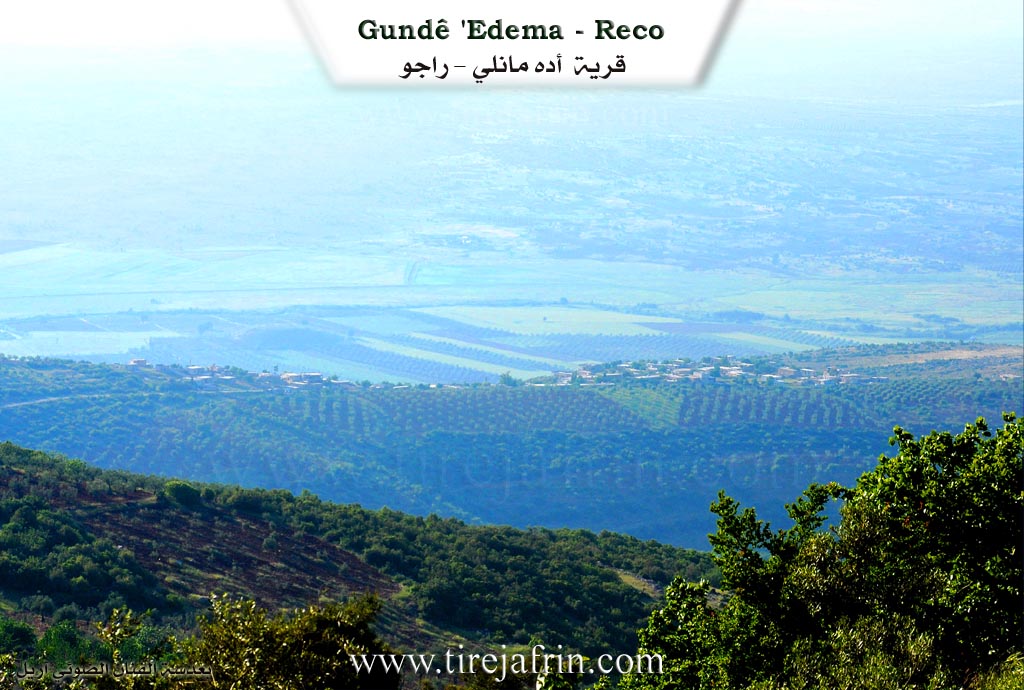
It is stated in the book Çiyayê Kurmênc (Efrîn) A Geographical Study: Edema, Edemanlî, Ede /1142 inhabitants, 174 hectares, 18km, 570m/:
Edemanlî: The name of a Kurdish tribe found to the north of Lake Wan /Zekî Vol 1 p407/. The Arabized name "Ede" is part of the name and has no linguistic meaning.
It is a small village located on the western side of Çiyayê Bilalîko. The Çemê Reş and the railway line pass to its west, and it is a distance of 2km from the Turkish border.
It is stated in the book Efrîn... Her River and Her Green Hills: Edemanlî is a village in Çiyayê Kurmênc following the district of Reco, Efrîn region, Heleb governorate. It is a medium sized village located in the northwestern part of Çiyayê Kurmênc and the Heleb plateau on the summit of a limestone elevation that slopes steeply toward the west, overlooking Deşta Amiq and the Çemê Reş which is 2km away, running parallel to the Xeta Trêna Heleb-Meydan Ekbez (Heleb-Meydan Ekbez railway). It is 18km away from the town of Reco toward the north.
It is bordered to the north by a mountain range and harsh slopes planted with oak trees, the plain of Meydan Ekbez, and the village. To the south, it is bordered by a high mountain range planted with oak and acorn trees and the village of Elî Beskî. To the east, it is bordered by a deep and harsh ravine and the village of Sîmalk Reco. To the west, it is bordered by a rugged mountain slope, Deşta Amiq, and the Turkish Çemê Reş directly.
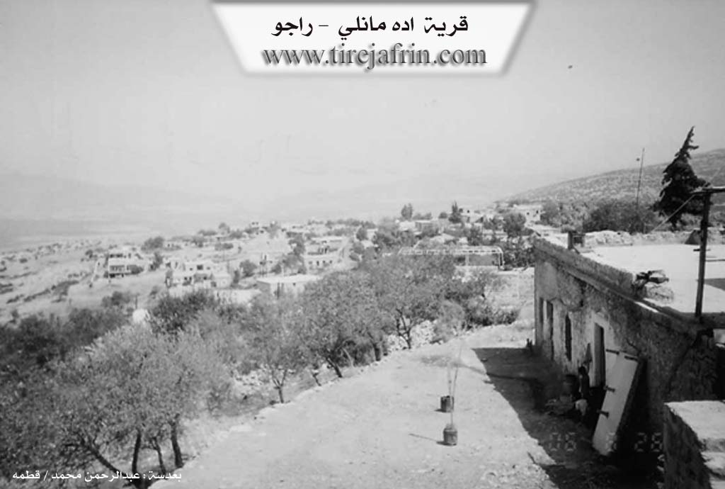
The number of its houses amounts to about 65 houses, and its age is about 350 years. Its dwellings are stone and mud with flat wooden roofs, and modern cement dwellings are extending toward the north and south. An electricity network, a primary school, and a paved road up to the center of the village are available in it. The village drinks from cisterns in which rainwater is collected in winter. The residents work in rain fed agriculture (olives, grains, legumes, grapes) on an area of 175 hectares, and they raise sheep and goats.
Village Mukhtar: Ekrem Osman
Sources of Information:
- Book: جبل الكرد (عفرين) دراسة جغرافية Çiyayê Kurmênc (Efrîn): A Geographical Study by د. محمد عبدو علي Dr. Mihemed Ebdo Elî.
- Book: عفرين .... نهرها وروابيها الخضراء Efrîn... Her River and Her Green Hills by عبدالرحمن محمد Ebdulrehman Mihemed from the village of Qetme.
- Studies of Navenda Tirej Soft / Ebdulrehman Hacî Osman.
- Some residents of the villages.
Preparation and execution: Manager of the site Tirej Efrîn: Ebdulrehman Hacî Osman 20/12/2013
II. Summary of Edema from Ax û Welat
Source: https://www.youtube.com/watch?v=XB2qkXNwfTQ
The village of Adema, also referred to as Edamo, is located in the Raco district within the Efrîn region. It lies 21 kilometers north of Raco and just 3 kilometers from the border of Bakurê Kurdistanê. The expansive plains surrounding the area are known as Wêranşarê and Sêmal.
The name Adema originates from Edem, who is believed to be the first settler of the village. According to local history, Edem and another figure named Cela established neighboring communities. Cela founded the village of Cela, while Edem settled in what became Adema. Originally, the village was situated in the plain closer to the modern border. After the border was established, the community was divided. One part remained in Bakurê Kurdistanê, while the other section relocated into the mountainous areas of Çelîşîn and Qerabêlê.
The residents of Adema primarily belong to the Celalî tribe. An elder named Ridwan notes that the earliest family to arrive in 1850 was the Mihiyê Sîlam family. Other prominent families include Eliyê Reşkê, Elo Simîn, Şêxdada, Mistiko, Hisînê Simo, Ebdilfoyê, Kêmek, Mehmê Reşît û Dadê, and Bêrek. Historically, figures such as Simalî Elî, Mistiko, Hase, and Bakirê Şêxda served as community leaders, often gathering in village guest rooms to resolve local disputes.
The village is surrounded by significant natural and historical landmarks. It spans the valleys of Çîlo, Banê, and Silo, and features striking rocky formations like Zinarê Sor and Binê Sor. Notable caves include Ebeş and Mistî Dede. There are also ruined sites nearby, such as Xirabê Silik and Xirabê Ebdû. The latter contains four caves and a spring known as Kaniya Korikê, where villagers historically gathered to wash their clothes. Several shrines hold spiritual importance for the community, including Axmeşo, Selo, and Yaxmûr Dede. Yaxmûr Dede is situated right on the border, and locals historically visited it to perform sacrifices and pray for rain during droughts. Another traditional gathering spot for village women was around a large rock named Kevirê Vahasê.
The villagers are deeply involved in agriculture, cultivating wheat, chickpeas, cucumbers, and other seasonal vegetables. Before border restrictions and market changes, they also grew cotton extensively. Beyond farming, the village preserves traditional crafts. Women still weave protective talismans and decorative strings to ward off the evil eye, a practice historically used to protect new brides. The older generation fondly recalls communal games and traditional celebrations. During weddings, local singers like Hisûyê Bilê and Hisênê Bekirê Şêx would perform traditional folk songs like Gulê Zer while the community danced. The village also honors its fallen martyrs, specifically remembering Ferîd, Merwan, Berxwedan Efrîn, and Kurd Efrîn, with local institutions named in their memory.
II. Ax û Walat Book 1
THE VILLAGE OF EDEMA
19/8/2016
The village of Edema is affiliated with the Reco district of the Efrîn canton. It is located 21 km north of the city of Reco and 50 km north of the city of Efrîn, and also 3 km from the border of Northern Kurdistan.
The village's name comes from the first person who settled in the village. It is said that there were two brothers named 'Edem and Cela, and Cela founded the village of Cela, and Edem also settled here and the village's name became Edema.
84
The village of Edema was previously on the Wêranşerê plain, but later the people of the village settled in the mountains.
The number of houses in the village is 110, and the population is nearly 1100 people. Most of the villagers are from the Celaliya tribe. It is worth mentioning that there is another village with the same name, but it is across the border, that is, in Northern Kurdistan, opposite each other.
To the east of the village are the Qere Bîlê mountain, Benê Sor, and the Yaşilê valley, where there are two caves known by the name (Mistî Dedik).
To the south are the village, Xirabê Solik, the village of Qerebaba, Elbîskê, and the Heşargê Bridge. There is also a shrine there by the name of (Se’bê Sorik). There was previously a village named (Selo), and that village is now in ruins because a war occurred there and the people moved away, only a cemetery and a cistern remain behind.
To the west of the village is the border of Northern Kurdistan, which is only 3 km away from the village. The Ava Reş river also flows nearby and passes into Efrîn. A shrine by the name of (Yaxmûr Dede) and the Nêsir bridge are near there, and around the water, farmers have made orchards of vegetables and fruits such as figs, pomegranates, grapes, and....
85
There are 15 water wells in the village from which the villagers get their drinking water, as well as for watering their gardens and trees, and also for watering their sheep and livestock.
There is a ruin by the name of (Xirabê Ebdo), it has 4 caves and also a water spring by the name of (Kaniya Kurkê). Previously, the villagers would visit there to wash their clothes and garments.
To the north of the village are the town of Meydan Ekbez and the villages of Meydana. The border of Northern Kurdistan is also there, and there is a dam on the Ava Reş river in the ISLEHİYÊ district.
The village cemetery is to the north of the village, and there is a wide plain named (Deşta Wêranşerê).
There are 4 martyrs from the village who were martyred at different times, they are:
Ş. Ferîd, Merwan, Berxwedan Efrîn and Ş. Kurd Efrîn.
The village commune is named Ş. Merwan.
There is a primary school in the village named Ş. Ferîd.
The villagers make their living from agriculture, from cultivating olive groves, vegetable gardens, and grains. Along with agriculture, some families own livestock such as sheep and goats and make their living from them. There is a famous tailor shop in Efrîn, and more than a few young men
86
from the village work there. Also, a number of men and women work as employees in the institutions and bodies of the Autonomous Administration in Reco and Efrîn.
Transcriptions and Subtitles
| Source | Video | Subtitles | Transcript |
|---|---|---|---|
| Ax û Welat 1 | Watch Video | Download SRT | View Transcript |
Possible Village Name Meaning of Edema
The name Adh Manli refers to a Kurdish tribe found north of Lake Van. The Arabic name "Adh" is part of the name and has no linguistic meaning.
Source: TirejAfrin Site