General Information
Nahiya (Subdistrict)
Reco
Also Known As
Ali Beski, Elbbîskê, Elbîskê, Elî Bîskê, العليا, العلياء, علي بسكي, علبيسكه
Tribes
'Emrîkan, Besk, Millî
Families, Clans, etc.
Mala 'Elbîskê, Mala Binbiş, Mala Mihekê

Photos
Basic Information about Elbîskê
Source: Afrin 366
Etymology: Named after the first family to settle the village, Mala 'Elbîskê
Foundation Date/Period: Approximately 60 to 70 years ago
Hills: Çiyayê Gewr, Çiyayê Tirkiyê
Other Landmarks: Kilîla Kurdistanê, Kilkê Kurdistanê, Gola mileta, Muselles, Yûlçatê
Summaries
I. Summary from TirejAfrin Site (English) of Elbîskê
Source: https://www.tirejafrin.com/site/kura%20afrin%20%20%20Reco%20-ali%20baske.htm
According to the book جبل الكرد (عفرين) دراسة جغرافية Çiyayê Kurmênc (Efrîn): A Geographical Study by د. محمد عبدو علي Dr. Mihemed Ebdo Elî: Elbsk, Elî Beskî, El Elya: /560 inhabitants, 94 hectares, 15 km, 870 m/:
Besk: Name of a Kurdish tribe, from the Millî clan /Zekî, Vol 1, p 398/, and Elî is a local proper name.
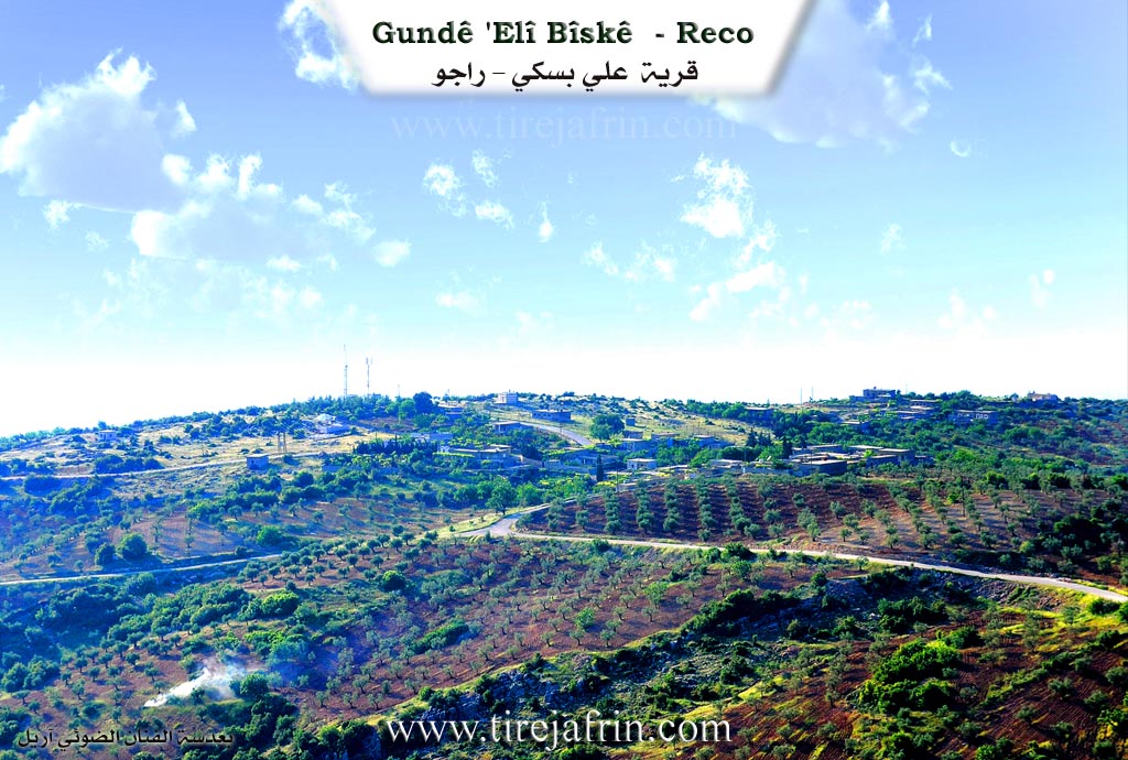
It is a small village, located on a mountainous site whose slopes descend steeply with terraces towards the west, amidst dense forests. The village has a beautiful location overlooking the plain of Lîçe with captivating views.
According to the book: عفرين .... نهرها وروابيها الخضراء Efrîn... Her River and Her Green Hills by the writer عبدالرحمن محمد Ebdulrehman Mihemed from the village of Qetme:
Elî Beskî: A village in Çiyayê Kurmênc administratively belonging to the Reco sub district, Efrîn region, Heleb governorate. It is a small village located in the northwestern part of Çiyayê Kurmênc and Heleb atop a flat limestone rocky surface. Its slopes descend steeply towards the north and slowly towards the other directions. Its soil is clay, and pastures are spread over it.
It is 15 km away from the town of Reco towards the north. It is bordered to the north by a rugged slope and the farm of Erebli, to the south by a high rugged mountain range and the village of Walîklî, to the east by a harsh rugged slope planted with oak trees and the village of Bilalîko, and to the west by a high mountain range planted with oak and holm oak trees and the village of Selûk.
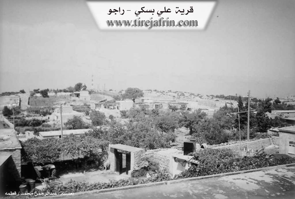
The number of its houses reaches about 35 houses and its age is about 200 years. Its old dwellings are stone and mud with flat wooden roofs, while modern ones have extended in the southern and western directions. An electricity network, a road, and a primary school are available in it, as well as a paved road up to the center of the village.
The residents work in rain fed agriculture (olives, cherries, vines, Aleppo pistachio, walnuts) on an area of 94 hectares. A section of them works in the charcoal industry from oak wood in the nearby forests. The village drinks from cisterns dug in front of the houses where rainwater collects in winter, in addition to raising sheep and goats. It is one of the villages called the Meydaniyên Bakur (Northern Meydaniyat) of the Reco sub district.
Village Mukhtar: Mihemed Ehmed Elî
Sources:
- Book: جبل الكرد (عفرين) دراسة جغرافية Çiyayê Kurmênc (Efrîn): A Geographical Study by د. محمد عبدو علي Dr. Mihemed Ebdo Elî.
- Book: عفرين .... نهرها وروابيها الخضراء Efrîn... Her River and Her Green Hills by عبدالرحمن محمد Ebdulrehman Mihemed from the village of Qetme.
Preparation and execution:
- Manager of Tirej Efrîn site: Ebdulrehman Hacî Osman
- 20/12/2013
II. Summary of Elbîskê from Afrin 366
Source: https://www.youtube.com/watch?v=lYecIO-M448
The village of Elbîskê is located in the Rajo district of the Afrin region, nestled in a mountainous area that locals describe as the Kilîla Kurdistanê or Kilkê Kurdistanê, meaning the Key or Finger of Kurdistan. The village is situated approximately ten kilometers from the center of Rajo. From the village, one can see the mountains across the border, referred to as Çiyayê Tirkiyê, and specifically the location of Yûlçatê. The local geography is defined by high elevations where the wind blows strongly from Çiyayê Gewr, keeping the area cool even during hot weather.
According to the resident elder Ebû Semîr, the history of Elbîskê is relatively recent compared to ancient settlements in the region. He states that the village was founded approximately 60 to 70 years ago. The village takes its name directly from the first family to settle the land, the Mala 'Elbîskê. Ebû Semîr connects the village to the wider tribal confederation of the region, noting it is one of the seven villages of the 'Emrîkan. While the village historically contains 45 households, the population has dwindled significantly due to political instability and displacement. At the time of the recording, only 17 or 18 families remained in residence, with many former inhabitants now living in Heleb or having emigrated to Europe.
The social structure of Elbîskê is defined by three primary families. Apart from the founding lineage of Mala 'Elbîskê, the village is home to Mala Binbiş and Mala Mihekê. Ebû Semîr confirms that the village is primarily known by these three distinct households. The community relies on agriculture, cultivating olives, walnuts, almonds, and figs without the aid of local shops, forcing residents to travel to Rajo for supplies.
A notable historical landmark discussed by the speakers is the Gola mileta, a communal pond located near the Muselles intersection where the roads to Elbîskê, Cengê, and 'Edema meet. Before the government excavated modern wells, this pond served as the critical water source for these three villages. Residents would bring their livestock and mules to this central spot to drink. The area also features a destroyed school, highlighting the impact of recent conflicts on the village infrastructure. The speakers also emphasize a local custom rooted in religious tradition, where ancestors would plant fig trees along the roads as an act of charity. They cite a Hadith suggesting that any fruit eaten from these trees by travelers, birds, or animals counts as a blessing for the planter.
Transcriptions and Subtitles
| Source | Video | Subtitles | Transcript |
|---|---|---|---|
| Afrin 366 1 | Watch Video | Download SRT | View Transcript |
Possible Village Name Meaning of Elbîskê
Named after the Bîsk Kurdish tribe, with "Ali" being a local proper name.
Source: TirejAfrin Site