General Information
Nahiya (Subdistrict)
Mabeta
Tribes
Biyan
Families, Clans, etc.
Bavkê, Bekirê Reşo, Ebû Reşîdê Şêx, Ebû Selah, Ehmed, Eme, Hecbirîm, Hemê Recê, Hemû Elî Caro, Hesûnê, Kurdî, Mele Xelîl 'Ezîz, Mihemed Îbo, Omer Oso, Osê, Wehîd, Şe'ro, Şêxê
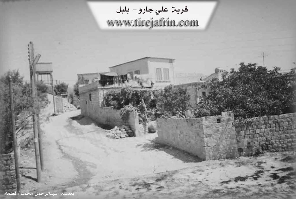
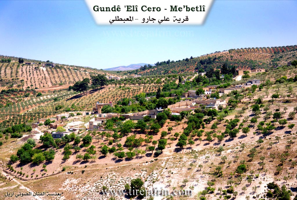
Photos
Basic Information about Elcara - Mabeta
Source: Ax û Welat
Etymology: Alciyara is named after its founder Eliyê Jare, originally Elî Jare or Elî Carû; Reca is named after its founder Recê Çûmezin
Caves: Şikefta
Springs: Kaniya Mîra
Hills: Gaza Zêra, Çiyayê Eliyê Omê
Ruins: Aşê Elî Axa
Trees: Çinar
Wells: Bîra Eliyê Carat
Other Landmarks: Çemêreşkê, Geliyê Şêran, Geliye Bîrê
Source: Afrin 366
Hills: Tirmîşa
Ruins: Hewşa Kavlorê
Trees: Darê jiyê
Other Landmarks: Mekteb
Summaries
I. Summary from TirejAfrin Site (English) of Elcara - Mabeta
Source: https://www.tirejafrin.com/site/kura%20afrin%20%20%20mebetli%20-%20elcara.htm
The following states in the book جبل الكرد (عفرين) دراسة جغرافية Çiyayê Kurmênc (Efrîn): A Geographical Study by د. محمد عبدو علي Dr. Mihemed Ebdo Elî:
Elcara, Elî Caro / 226 inhabitants - 13km - 670m / :
The origin of its name is 'El Jar', meaning "Ali the slender," or more correctly "Ali son of the slender one." It is a small village located on a plateau furrowed by streams in all directions.
The following states in the book عفرين .... نهرها وروابيها الخضراء Efrîn... Her River and Her Green Hills by the writer عبدالرحمن محمد Ebdulrehman Mihemed from the village of Qetme:
Elî Caro: A village in Çiyayê Kurmênc, administratively belonging to the Mabeta district, Efrîn region, Heleb governorate.
It is a small village located in the central part of Çiyayê Kurmênc, on the western slope of a limestone plateau furrowed by torrential valleys from the east and west. It is 12km away from the village of Mabeta towards the southwest. Its soil is clay, with pastures and forests spread above it.
It is bordered to the north by a mountainous highland planted with olive trees and the village of Qişlê; to the south by a steep slope, a very deep torrential valley, mountainous highlands planted with olive trees and forests, and the village of Mistû Aşûr; to the west by a deep stream, mountainous highlands planted with olive trees and forests, and the village of Maxarcix; and to the east, 50m away, is the nearby village of Hemê Reco.
Its soil is clay, with pastures and forests spread above it. The number of its houses is about 35, and its age is about 350 years. Its dwellings are stone and mud with flat wooden roofs, and cement buildings have begun to overtake them.
An electricity network is available, as well as a primary school shared between the village of Qişlê, Meserê Cix, and Hemê Reco. There is a modern olive press in the village. Its residents drink from a well west of the village (500m) and from cisterns that collect rainwater in winter. There is a very small mosque in the village. A paved road connects it to the district center, passing through its center to the neighboring villages.
Its inhabitants rely on rain-fed agriculture (olives, grains, walnuts, and almonds) alongside raising sheep and goats. Among its most important families: the family of Omer Oso or Hemû Elî Caro; they were the first to inhabit the village, so the village was named after its first inhabitant.
Village Mukhtar: Remzî Heqî
Preparation and Execution:
Manager of Tirej Efrîn site: Ebdulrehman Hacî Osman
20/12/2013
Sources:
- Book: جبل الكرد (عفرين) دراسة جغرافية Çiyayê Kurmênc (Efrîn): A Geographical Study by د. محمد عبدو علي Dr. Mihemed Ebdo Elî.
- Book: عفرين .... نهرها وروابيها الخضراء Efrîn... Her River and Her Green Hills by عبدالرحمن محمد Ebdulrehman Mihemed from the village of Qetme.
II. Summary of Elcara - Mabeta from Ax û Welat
Source: https://www.youtube.com/watch?v=qMOth87MVrw
The villages of Alciyara and Reca are located approximately 11 kilometers west of the district of Mabeta in the Afrin region. Although they are technically two distinct settlements, they function socially and administratively as a single entity, sharing a commune, a mosque, a cemetery, and a school. The residents are closely bound by kinship and shared history, with the physical boundaries of the villages merging over time. The economy is primarily agrarian, dependent on olive groves and fruit trees, with water traditionally sourced from local wells and springs due to the high elevation.
The origins of Alciyara are traced back to a founding figure named Eliyê Jare, also known as Elî Carû in Arabic contexts. His descendants form the core population of the village, rooted in the Biyan tribe. According to local oral history, Eliyê Jare had four sons named Hecbirîm, Os, Ehmed, and Şêxê, whose lineages constitute the primary families of Alciyara, along with the Hesûnê and Eme families. The village name itself evolved from Elî Jare to Alciyara through linguistic shifts over generations.
The history of Reca is defined by its founder, Recê Çûmezin. Oral traditions state that Rec was the son of Çûmezin. Rec settled in the current village location, while his brothers migrated elsewhere; one brother established the Kurdî family in Sewliyê near Atme, and another named Hemê Recê settled near Recû. The village of Reca is home to three main families: Osê, Hemê Recê, and Wehîd. Additionally, the Şe'ro and Bekirê Reşo families migrated to Reca from Gûrda.
The landscape around the villages is rich with historical and natural landmarks. A stream known as Çemêreşkê, also called Geliyê Şêran, runs below the villages. Along this watercourse lies the ruin of an ancient water mill known as Aşê Elî Axa. To the south lies Gaza Zêra, an area noted for its olive trees and construction, and Çiyayê Eliyê Omê. The villagers historically relied on the Bîra Eliyê Carat well and the Kaniya Mîra spring. A significant historical site mentioned is a Roman era well located in Geliye Bîrê, which historically supplied water to seven surrounding villages including Me'serkê, Birqasê, and Çûmazna. Near this well stands a massive Çinar tree, estimated by locals to be 1300 years old, predating the era of Selahedîn.
Elder residents like Apê Remzî recall the French Mandate era, noting that local men were conscripted into the French army or worked in their outposts from Ezaz to Cerablûs. The region saw resistance from local figures such as Çûlaq and Mihdînê Îbşo, who fought against French forces. The village school, which served five surrounding villages, was notably closed in 1958. Despite administrative name changes imposed by successive governments, the villagers have retained their original Kurmanji names for their homes and landmarks.
II. Summary of Elcara - Mabeta from Afrin 366
Source: https://www.youtube.com/watch?v=bsZnaYoU4bE
The village of Elîcaro, which is also referred to by the Arabic name Ancaro, is located in the Çiyayê Kurmênc region within the administrative jurisdiction of Mabato. It is situated approximately 10 kilometers away from the town of Mabato. The settlement is relatively small and contains about 40 households. The social structure is described as very cohesive, with residents referring to one another as cousins and stating that there are no strangers among them.
The transcript identifies several specific families and households that make up the community. The video documentation was requested by Ciwan Ehmed Elî, who is associated with the house of Ebû Selah. Other specific households mentioned include the families of Mihemed Îbo and Mele Xelîl 'Ezîz, although the speakers note that these particular families were not present in the village at the time of filming. Historical continuity is evident in the architecture, with specific mention of the Hewşa Ebû Reşîdê Şêx and Hewşa Bavkê. One notable structure is referred to as Hewşa Kavlorê, where inscriptions date the construction or renovation to 1960 and 1977.
Daily life in Elîcaro revolves around agriculture, specifically olive farming. Residents such as Ebû Şadî have worked in the olive groves for decades, performing tasks like kesaẍê or pruning. The village relies on external sources for some provisions. There is no local bakery, so bread is brought in from Mabato or the nearby village of Hisêr. Water is managed through cisterns known as Birkê or delivered by trucks. The village contains a primary school, referred to as the Mekteb, which provides education for children up to the sixth grade.
The geography surrounding Elîcaro includes several neighboring villages and landmarks. Directly opposite lies the village of Berko, and nearby is the smaller hamlet of Me'serkê, which consists of about 20 households. Other neighboring locations include Indîdarê, Raco, Tirmîşa, Çoman, and Mayê. Within the village boundaries, there are remnants of the past, including a significant tree called Darê jiyê and ancient stone olive presses referred to as Deryûb or Gilê. The speakers also mention a ruined site called a Meqbez, which served as an old cemetery or religious site but is now in disrepair.
Transcriptions and Subtitles
| Source | Video | Subtitles | Transcript |
|---|---|---|---|
| Afrin 366 1 | Watch Video | Download SRT | View Transcript |
| Ax û Welat 1 | Watch Video | Download SRT | View Transcript |