General Information
Nahiya (Subdistrict)
Efrîn
Also Known As
Gazê, Kaza, Xazê, تل غازي, غازي تبه, كازه
Tribes
Reşkeş
Families, Clans, etc.
Brîmo, Brîmê Hecî, Ehmedê Îbiş, Evdî Gênco, Hesen Efendî, Imrûdê Hecî, Mala Birîmê Hecî, Mala Ebolî, Mala Ehmedê Îbiş, Mala Eqêş, Mala Evdî Gênco, Mala Eşburcêne, Mala Hesen Efendî, Mala Heyder Axa, Mala Mele Mihemed Evdê, Mala Qejiyan, Mala Umer, Mala Xelîc, Mala Êvî, Mala Îbo, Mala Îbrahîmê Hacî, Mihemedê Evdek, Okçerîn, Îbo, Îbram Axa
Photos
Basic Information about Gazê - Erfîn
Source: Ax û Welat
Etymology: Derived from 'Gaz' meaning 'high' or 'ridge' (bilind), specifically implying a high and long place, as it is situated on Çiyayê Hişyan
Foundation Date/Period: 250 years ago
Number of Caves: 1
Hills: Çiyayê Hişyan, Sirtê Gazê, Çiyayê Şêx Mîrê, Girê Mûsa
Shrines: Ziyaretgeha Hemedê
Wells: Bîra Hecî Mîra, Bîra Keferdelê, Bîra Hecî Mîrêd
Other Landmarks: Geliyê Bîrê, Geliyê Çêtê, Geliyê Ecûre, Geliyê Bîra Hecî Mîrêd
Summaries
I. Summary from TirejAfrin Site (English) of Gazê - Erfîn
Source: https://www.tirejafrin.com/site/kura%20afrin%20markaz-%20xaze.htm
The following states in the book جبل الكرد (عفرين) دراسة جغرافية Çiyayê Kurmênc (Efrîn): A Geographical Study by د. محمد عبدو علي Dr. Mihemed Ebdo Elî: Gaz, Ghazî Tepe, Tell Ghazî / 548 people - 177 hectares - 9km - 670m /:
Gaz or "Ghaz" as it is written in Arabic, means "the elongated height" (gaz) in Kurdish. The village is located on an elongated hill oriented east to west. The Arabized name is an incorrect Arabic translation of the old name, as is the Ottoman Turkification name. The translators believed that "Ghazî" was the Turkish word meaning "hero," so they named it Ghazî Tepe in Turkish and Tell Ghazî in Arabic.
It is a small village located atop one of the limestone peaks of Xastiyan mountain, with very steep slopes. It is one of the villages with a high rate of emigration, and it also has a high percentage of holders of university and graduate degrees.
The following states in the book عفرين .... نهرها وروابيها الخضراء Efrîn... Her River and Her Green Hills by the writer عبدالرحمن محمد Ebdulrehman Mihemed from the village of Qetme:
Ghazî Tepe / Gazê: A village in Çiyayê Kurmênc, belonging to the villages of the Efrîn center and district, Heleb governorate. It is a small village located on the highest mountain peak, surrounded by slopes on all sides except the north. It is bordered to the north by a mountain range planted with trees and vines, the large village of Dar Kîr, and Mabeta. To the south, it is bordered by a harsh slope, a deep and rugged watercourse valley, a mountain range planted with olive trees, and the villages of Kefer Delê Jorîn and Kefer Delê Jêrîn. To the west, it is bordered by a harsh slope, a deep and rugged watercourse, a mountain range planted with olive trees, and the village of Satiyan. To the east, it is bordered by a slope, a deep watercourse, and the village of Büyük Oba or Al-Kabir.
A deep watercourse separates two villages. The number of its houses is about 30, and its age is 500 years. Its old houses are made of stone and mud with flat wooden roofs, while the modern ones are cement. It is one of the old villages in the region. An electricity network is available, as well as a paved road up to the middle of the village. They drink water from pools and artesian wells. Its old houses are stony, made of mud and wood, while the modern ones are of reinforced concrete.
The people of the village work in agriculture, cultivating olives, vines, and other fruit trees such as almonds, pomegranates, and apricots. It is a village distinguished by its beautiful location on a high elevation. The first to inhabit the village was the family of Hesen Efendî.
Among the holders of higher degrees in the village are:
Ednan Ebdî son of Ebdo / PhD in Petrochemicals / Russia.
Gulistan Murad Ibrahîm / PhD in Gynecological Surgery / Russia.
Mihemed Ebdo / PhD in Agriculture / Russia.
Village Mukhtar: Mihemed Ebdo Osman.
Preparation and execution:
Manager of Tirej Efrîn site: Ebdulrehman Hacî Osman
20/12/2013
Sources
Book: جبل الكرد (عفرين) دراسة جغرافية Çiyayê Kurmênc (Efrîn): A Geographical Study by د. محمد عبدو علي Dr. Mihemed Ebdo Elî.
Book: عفرين .... نهرها وروابيها الخضراء Efrîn... Her River and Her Green Hills by عبدالرحمن محمد Ebdulrehman Mihemed from the village of Qetme.
Navenda Tirej Soft / Ebdulrehman Hacî Osman.
I. Summary from TirejAfrin Site (English) of Gazê
According to the book جبل الكرد|Mountain of the Kurds geographical study by Dr. Mohammed Abdo Ali:
Gazê, غازي تبه, تل غازي /548n - 177h - 9km - 670m/:
- Gaz "غاز" or "غاز as written in Arabic", it is in Kurdish meaning "the long elevation", and the village is located on a long hill in an east-west direction. The Arabized name is an incorrect Arabic translation of the old name, as well as the Ottoman Turkish name, where the translators believed that "غازي" is a Turkish word meaning "hero", so they called it "in Turkish غازي تبه, and in Arabic تل غازي".
- A small village located on one of the limestone peaks of Heshtya mountain, its slopes are very steep. It is one of the villages with a large migration rate, and there is also a high percentage of holders of university and higher academic degrees.
And it came in the book: Afrin... Her River and Green Hills by writer Abdulrahman Mohammed from Qatma village
غازي تبه / كازه: A village in Mountain of the Kurds, belonging to the center villages and Afrin, Aleppo Governorate.
It is a small village located at the highest mountainous elevation, and around it are slopes from all directions except the northern direction. It is bordered to the north by a mountain chain planted with trees and vineyards and Dar Kir large village and Ma'batli and to the south by a harsh slope and deep stream and rough terrain and high mountain chain planted with olive trees and Kafr Dali Fouqani and Tahtani villages and to the west by a harsh slope and deep stream and rough terrain and high mountain chain planted with olive trees and Satianli Village and to the east by a slope and deep stream and Buyuk Oba or al-Kabir village. A deep stream separates the two villages. The number of its houses reaches about 30 houses and its age is 500 years. Its old houses are stone mud with flat wooden roofs and the modern ones are cement. It is one of the ancient villages in the region. It has electricity network and a paved road to the village center and they drink water from pools and artesian wells. Its old houses are stone and mud and wood while the modern ones are of reinforced cement. The village residents work in agriculture and olives and vineyards and fruit trees and other fruit-bearing trees like almonds and pomegranates and apricots. It is a village distinguished by its beautiful location on a high elevation and the first to inhabit the village was Hassan Afandi family.
Among the holders of higher degrees in the village: Adnan Abdi bin Abdo/doctorate in petrochemistry/Russia - Kalstan Murad Ibrahim/doctorate in gynecological surgery/Russia - Mohammed Abdo/doctorate in agriculture/Russia
Village mayor: Mohammed Abdo Othman
Preparation and implementation: Director of Tireij Afrin website: Abdulrahman Haji Othman
20/12/2013
II. Summary of Gazê - Erfîn from Ax û Welat
Source: https://www.youtube.com/watch?v=2weZQvWl0sQ
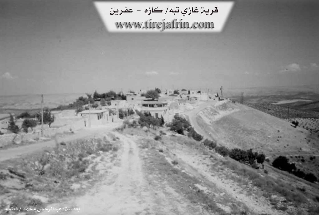
The village of Gazê is located in the Cindirês district of the Efrîn region, situated approximately 15 kilometers northwest of Cindirês and 15 kilometers west of the city of Efrîn. Perched at an altitude of 670 meters on Çiyayê Hişyan (Hişyan Mountain), the village's name reflects its geography, meaning "high" or "ridge." It overlooks a landscape defined by valleys such as Geliyê Bîrê, Geliyê Çêtê, and Geliyê Ecûre.
The village was founded by Hesen Efendî, whose family lineage has been present in the region for approximately 250 years. While the village itself is described as old, its population expanded from a small core of about 20 households. The primary inhabitants descend from the Hesen Efendî line, branching into several key families: Evdî Gênco, Ehmedê Îbiş, Mihemedê Evdek, and Îbram Axa (which further includes Imrûdê Hecî and Îbo). Other residents include the Brîmê Hecî family, the Okçerîn family, and the Reşkeş, who are described as a tribe (aşîret) with nomadic origins. The Brîmo family is noted to have migrated from Darkirê. In the mid-20th century (1940s-50s), a branch of the Hesen Efendî family moved to settle in Têlif and Til Hemû.
Gazê has a rich history of resistance and cultural preservation. Ehmedê Îbiş was a notable figure who rebelled against the French mandate in 1938, serving prison time in Heleb and Beyrût alongside companions like Mehmed, Kaş, and Weqas. The village is also proud of its educational achievements, boasting a high number of university graduates, doctors, and engineers, despite originally lacking a formal school until the community built one themselves in 1967. It holds the distinction of lighting the first Newroz fire in the area on the mountain of Gazê in 1961, an act for which local residents faced persecution by the Syrian state.
A central social and historical landmark is the well known as Bîra Hecî Mîra (or Bîra Hecî Mîrêd), located in the valley of the same name. Historically, this site served as a vital water source and a gathering place for surrounding villages like Koxre, Şîtka, Huse, Dargirê, and Maratê. Elders describe how the water originally flowed as a spring before being contained into a well due to decreasing water levels. The area around the well features ancient trees and is near the Ziyaretgeha Hemedê shrine and Çiyayê Şêx Mîrê.
Economically, the village relies on olive cultivation, as well as walnuts, almonds, and vineyards producing grape varieties such as Frensî, Dukulgan, Zehlawî, and Şihê. While sheep herding was once a major part of life, with shepherds using the Girê Mûsa market, it has declined in favor of agriculture. The village is also the home of the artist and agricultural engineer Dr. Muhamed Abdo, who preserves Kurdish musical traditions. A local commune is named in honor of Şehîd Şêro, a martyr from the village.
II. Summary of Gazê - Erfîn from Khalil Sino
Source: https://www.youtube.com/watch?v=rCV8q3uktaA
The documentary explores the history and social fabric of the village of Gazê,
located in the Efrîn region. According to an elder resident named Hesen, the
village has an ancient history and was founded approximately seven hundred years
ago. The name Gazê derives from its geographical position, as the village is
situated on a high, elevated piece of land.
The foundational lineage of the village is Mala Hesen Efendî. Originally, this
family possessed lands in Til Hemîs, where Hesen Efendî held considerable
authority. However, following conflicts over property and the loss of lands to
Mala Heyder Axa, the family relocated and established Gazê. Today, the
descendants of Mala Hesen Efendî remain prominent and have expanded into
several household branches, including Mala Ehmedê Îbiş, Mala Îbo, [Mala
Ebolî], and Mala Evdî Gênco. Another major family that settled alongside them
is Mala Birîmê Hecî, which consists of several cousins. Additional families
that share the village include Mala Eqêş, Mala Umer, Mala Xelîc, [Mala
Êvî], Mala Qejiyan, Mala Mele Mihemed Evdê, and Mala Eşburcêne.
A central and historic feature of Gazê is its ancient water wells, which have
sustained the local residents and wildlife for centuries. The host and a local
man named Neşet visit a notable well referred to by the host as [Bîra Hecî
Mûrad] and identified by Neşet as Bîra Şêxmîr. This well is estimated to be
between three hundred and five hundred years old. Its underground spring water
flows toward the road of Dargir and into the valley below. Another prominent
well mentioned by the elders is Bîra Îbrahîmê Hacî. These wells are renowned
for never drying up, even during prolonged periods of drought. Historically,
they served as vital gathering places where villagers would milk their sheep,
host guests, and rest under the shade of walnut, apple, and mulberry trees.
The village is bordered by several neighboring settlements, with Keferdelê
located to the south, Maritê to the east, and Ka Xirê to the west. In the
past, children from Gazê walked to Keferdelê to attend primary school. In
recent times, Gazê has earned a strong reputation for its dedication to
education. Despite being a small village, it has produced numerous
professionals, including doctors, engineers, and teachers of the Arab and
French languages. Many residents migrated to Heleb or traveled abroad for
work, yet the community retains strong cultural practices. The women of the
village maintain traditional skills, such as distilling rose petals to make
homemade rose jam, and elder women like Xadîce share memories of crafting
traditional hair ornaments and performing arduous agricultural labor by hand.
II. Ax û Walat Book 2
17
GAZÊ
1.5.2017
[Image of the village of Gazê]
Ax û Welat
Gazê
The village of Gazê is affiliated with the Cindirêsê district of the Efrîn canton, located 15 km northeast of the city of Cindirêsê and 15 km west of the city of Efrîn. The village's elevation is 670 meters above sea level.
The name of the village of Gazê means ((High and long)) because it was built on Heştiya mountain; this mountain starts from the village of Çolaqa and ends at the village of Xerza.
There is a village with the same name in the Reco district near the villages of Meydana, but they have no connection to each other.
Hesen Efendî was the first person to settle in the village, and he is from the Heştiyan tribe, and it is said that they are connected to the Bedirxaniyan
18
e. Afterward, other families came. Hesen Efendî himself was a ruler or an Ottoman governor in the surrounding region.
It is worth remembering that Hesen Efendî's properties are around the village of Tilifê, and some people from Hesen Efendî's family settled in the village of Tilifê in 1945.
To the north of the village are the Bîrê valley and the village of Mezin; to the east, the Çetê valley and the village of Maratê; to the south, Bîra Keferdelê and the village of Keferdelê; to the west, the well of Hec Murad, the Hemedê shrine, the Ekûrê valley, and Şêx Mîrê mountain, where there is a water well, a cave, and old ruined houses.
There are 7 families in the village:
The families of Ebdê Gênco, Îbo, Ehmedê Îbiş, Mihemedê Ebdik are all from one root, from the family of Hesen Efendî; the family of Birîmê Hecî, Ukêş who are nomads, and the family of Birîmo came from the village of Dargirê.
33 houses and nearly 900 people live in the village, but around 30 families live in the city of Efrîn.
The people of the village make their living from agriculture, from olive groves, vineyards, apricots, walnuts, almonds, and sumac. In addition to agriculture, nearly 10 people work in various factories in Efrîn, and around 5 people work in the institutions and bodies of the Autonomous Administration. Some families raise sheep.
There is one martyr from the village named Martyr Şêro, and the village's commune is named after Martyr Şêro. There is no school in the village due to a lack of students.
19
Ehmedê Îbiş was a rebel against the French. In 1938, along with his friends, he worked extensively against the French and was imprisoned for 4 years in Aleppo and Beirut with Mihemed Ukaş Weqas.
Cemîlê Osê was the mukhtar of the village and provided many services to the village.
Xelîlê Hemdo, Muradê Hec Murad, and Xelîlê Hafiz were elders of the village and provided many services to the village, encouraging people to pursue education and resolving social problems.
Ferîde Hisko delivered all the children of the village.
The literacy rate in the village is high, and nearly 40 people have graduated from university, 10 of whom are doctors and pharmacists.
The first Newroz fire was lit in 1961 on the mountains of Gazê village, and the people who lit the fire were subjected to torture and imprisonment by the Syrian state.
Dr. Mihemed Ebdo, as an agricultural engineer who has obtained a Doctorate in agricultural engineering, also practices the art of being a dengbêj (bard).
Transcriptions and Subtitles
| Source | Video | Subtitles | Transcript |
|---|---|---|---|
| Ax û Welat 1 | Watch Video | Download SRT | View Transcript |
| Khalil Sino 1 | Watch Video | Download SRT | View Transcript |
Foundation/Origin Information of Gazê - Erfîn
The first to inhabit the village was Hassan Afandi family.
Source: TirejAfrin Site
Founded in 1945 by the family of Hesen Efendî.
Source: Ax û Walat Transcript
Possible Village Name Meaning of Gazê - Erfîn
Gaz in Kurdish means 'the long elevation', as the village is located on a long hill. The Arabized and Turkish names (Ghazi Tepe) came from a mistranslation, believing 'Gazê' was the Turkish word for 'hero'.
Source: TirejAfrin Site
Its name means 'high and long' in Kurmanji, reflecting its location on a mountain ridge.
Source: Ax û Walat Transcript
V. Links
- Tirej Afrin:
https://www.tirejafrin.com/site/kura%20afrin%20markaz-%20xaze.htm - Ax û Welat:
https://www.youtube.com/watch?v=2weZQvWl0sQ - Video:
https://www.youtube.com/watch?v=tYlsrnBfBuA - Link:
https://www.youtube.com/watch?v=BCStI1mrHKg - Link:
https://www.youtube.com/watch?v=VXnrQwc_0dQ - Link:
https://www.youtube.com/watch?v=4MI-M2RdDQI - Khalil Sino:
https://www.youtube.com/watch?v=rCV8q3uktaA