General Information
Nahiya (Subdistrict)
Mabeta
Also Known As
Al-Aqra, Ibrahîm el-Eqre', Kelo, Kulêbo, Kêl Îbo, Kêlîbo, الأقرع, كيل ايبو
Families, Clans, etc.
Belantîn, Cûcik, Hecî Xaşo, Kur Ehmedo, Kêlo, Mala Ekif, Mala Şewqî, Malê Nebê, Mamkû, Mehrem, Mezin, Miskêk Hemîdî, Najoh, Qicik, Sidqî, Tofan, Zekî

Photos
Basic Information about Kêl Îbo
Source: Afrin 366
Etymology: Named after a large stele or headstone (kêlî) that formerly stood in the location
Springs: Kaniya berbenê
Trees: Darê qitax, Darê Mekbezel
Other Landmarks: Pira Qutx, Qunaq, Mefraqa Kêlîbû, Rêka Rajo
Source: Khalil Sino
Etymology: Derived from Kêl (stone marker) and Îbo (short for Îbrahîm), referring to a marker for a man named Îbo; also associated with the prophet Îbrahîm Xelîl passing through
Foundation Date/Period: Ancestors arrived in the region (Be'dîna) approx. 600 years ago; village founded later after a family separation
Number of Caves: 1
Other Landmarks: Kittex
Summaries
I. Summary from TirejAfrin Site (English) of Kêl Îbo
Source: https://www.tirejafrin.com/site/kura%20afrin%20%20%20mebetli%20-%20kel%20ibo.htm
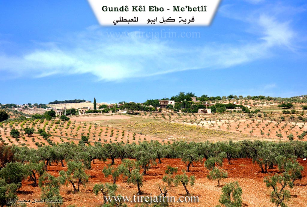
The book جبل الكرد (عفرين) دراسة جغرافية Çiyayê Kurmênc (Efrîn): A Geographical Study by د. محمد عبدو علي Dr. Mihemed Ebdo Elî states that Kel Îbo, also known as Al-Aqra, had 338 inhabitants and covered 1145 hectares. It is located 11 kilometers away at an altitude of 520 meters.
The name Kel Îbo comes from the proper name Ibrahim and his nickname "Al-Aqra" (The Bald). He was one of the earliest inhabitants of the village, and Îbo was a skilled player of the tembûr instrument. It is a small village situated on the far southwestern slope of Çiyayê Hawar.
According to the book عفرين .... نهرها وروابيها الخضراء Efrîn... Her River and Her Green Hills by the writer عبدالرحمن محمد Ebdulrehman Mihemed from the village of Qetme, Kel Îbo is a village in Çiyayê Kurmênc that administratively follows the Mabeta subdistrict in the Efrîn region of the Heleb governorate.
It is a small village located in the central part of the mentioned mountain range, on the southern slope of Çiyayê Hawar. It sits on a mountainous elevation with a steep incline and possesses clay soil. The village is 12 kilometers northwest of the town of Mabeta.
The village boundaries are defined as follows: to the north lies a high mountain elevation and the village of Oksûzlî. To the south lie a slope, the fertile plain of Kitix, the Riya Efrîn-Reco (Efrîn-Reco road), the Xeta Trêna (railway line), the village of Qitranlî, and Ereb Uşaxî. To the west lie a slope, Geliyê Tîra (Tîra valley), the railway, and the villages of Hemşilê and Bedinlî. To the east lie a slope, a plain, and the village of Heyat.
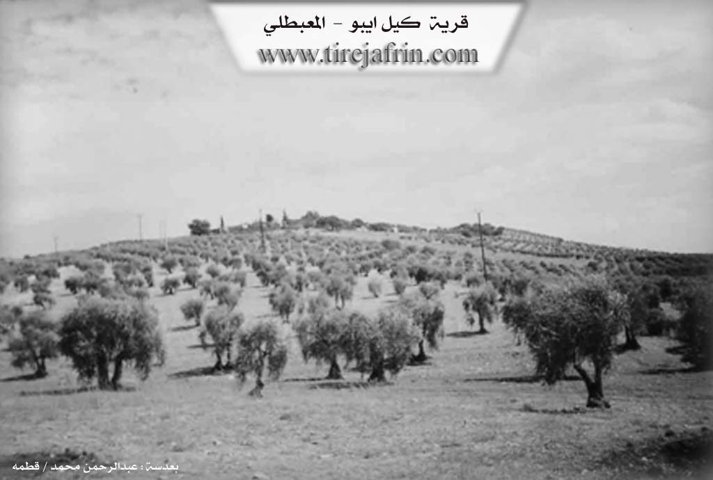
The village contains approximately 25 houses and is about 150 years old. Its old dwellings are made of stone and mud with wooden roofs, while the modern ones are made of cement. Construction is spreading toward the east and south, except for the northern side which consists of high mountains. The village has an electricity network and a water network connected to a well south of the village.
Residents work in rain fed agriculture on 250 hectares, cultivating grains, olives, grapes, and almonds. They also practice irrigated farming using artesian wells to grow summer vegetables and fruit trees such as walnuts, almonds, apricots, and cherries. The village is surrounded by trees on all sides and faces the open, fertile plain of Kitix. Among its most important families is the Kêlo family, who were the first to inhabit the village.
The village mukhtar is Farûq Hisên Menan.
Sources
Book: جبل الكرد (عفرين) دراسة جغرافية Çiyayê Kurmênc (Efrîn): A Geographical Study by د. محمد عبدو علي Dr. Mihemed Ebdo Elî.
Book: عفرين .... نهرها وروابيها الخضراء Efrîn... Her River and Her Green Hills by عبدالرحمن محمد Ebdulrehman Mihemed from the village of Qetme.
Preparation and execution:
Manager of Tirej Efrîn site: Ebdulrehman Hacî Osman
20/12/2013
II. Summary of Kêl Îbo from Afrin 366
Source: https://www.youtube.com/watch?v=zMaBXFZeroU
The documentary transcript focuses on the village of Kêlîbû and the adjacent historical site of Qutx in the Rajo district. The narrator explains the origins of the village name. He states that Kêlîbû is named after a large Kêlî, which is a Kurmanji term for a stele or headstone. This distinctive stone marker once stood in the area and became the namesake for the settlement established there.
A significant portion of the footage records the history of Qutx, also referred to as Qunaq. This location serves as a transit point defined by a massive iron railway bridge called Pira Qutx. A local elder named Ebû Semîr provides historical details about this structure. He explains that the bridge was constructed in the years 1911 and 1912. Although the railway is historically associated with the Berlin to Baghdad project, the speaker explicitly attributes the construction to Fransa. He notes that the date is inscribed directly onto the iron structure. This railway line connected Tirkiyê to Rajo, passing through to Efrîn and eventually reaching Heleb and Şamê.
The area around Pira Qutx historically functioned as a vital social hub for the region. Ebû Semîr describes a large and reliable spring that flowed beneath the bridge. People from the surrounding areas gathered there to rest, wash clothes, and enjoy the clean water. The narrator laments that this water source has recently dried up due to a lack of rainfall.
Regarding the social geography of Kêlîbû, the transcript identifies several specific households. The narrator points out homes belonging to Mala Şewqî and Mala Ekif. He also identifies trees belonging to Malê Nebê. There is a direct address to a man named Mistefo, likely a relative living abroad, showing him his family land and olive groves that have been plowed and maintained.
The landscape features other named landmarks. Near the intersection of the village, known as Mefraqa Kêlîbû, there was a specific spring called Kaniya berbenê. The narrator also highlights ancient trees in the area known as Darê qitax, which are estimated to be over one hundred years old. The tour concludes near the intersection leading to Ba'dîno, emphasizing the connectivity of Kêlîbû to the wider region.
II. Summary of Kêl Îbo from Khalil Sino
Source: https://www.youtube.com/watch?v=3ayfH66xpO0
The village of Kêlîbû is situated in the high altitudes of the Efrîn region, approximately 15 kilometers from Raco and 17 kilometers from the city of Efrîn. According to local elders, the name Kêlîbû is a compound of "Kêl" (stone or marker) and "Îbo," a diminutive for the name Îbrahîm. One resident explains that a man named Îbo had a marker here, and historically, the prophet Îbrahîm Xelîl is said to have passed in front of the village, cementing the association. During the period of Arabization, the village was officially renamed Îbrahîm el Eqre' or simply 'Eqre', though locals retain the original Kurmanji name.
The origins of Kêlîbû are deeply intertwined with the history of the nearby village of Be'dîna. Residents trace their lineage back to ancestors who migrated from Kurdistana Tirkiyê (Turkish Kurdistan) approximately 600 years ago. Specifically, the Miskêk Hemîdî line, including figures like Arifê Miskê, originally settled in Be'dîna. The founding of Kêlîbû as a separate settlement occurred following a dispute; the Kur Ehmedo family separated from the others ("tam nedan hevdû") and established the new village.
Socially, the village is small but boasts a close-knit community. While historically the population, including the diaspora, numbered around 60 to 100 households, currently only about 25 families reside there permanently. Prominent families mentioned include the Tofan family and the Sidqî family, the latter known for the musician Sidqî, father of Şivan. The village lacks certain infrastructure; there is no mosque, pharmacy, or school, forcing children to travel to Be'dîna or Raco for education. A communal bakery was once located at a spot named Kittex.
One of the village's oldest residents, Hesen Zîro (also referred to as Xalê Hesen), aged 98, shares personal history that reflects the village's resilience. About 50 years ago, unable to afford a house, he excavated a cave by hand to live in and house his livestock. He also constructed seven stone chairs (heft kirsê kevirî) for his seven sons, symbolizing the permanence of his family on the land, noting that while wood rots, stone endures. The village relies on a well drilled in 1974/1975 to address water scarcity, a significant event in the community's modern history. Residents maintain strong ties with Be'dîna, particularly for commerce and schooling.
II. Summary of Kêl Îbo from Khalil Sino 2
Source: https://www.youtube.com/watch?v=Dgvq6gyNOLw
The documentary focuses on the village of Kêlibiyê (also referred to as Kêlibû) in the Efrîn region. The narrative is anchored by the village elder, Xalê Şêxo (also known as Bavê Zuhêr), who provides a historical timeline for the settlement. According to Şêxo, the village was founded approximately 600 years ago. He characterizes the local population as resilient and martial, proudly recounting that their ancestors stood against the authority of local Aghas and fought a war against Fransa (France) during the colonial era. He emphasizes that they follow a path of honor, stating, "We follow the brave and the tough; we do not follow the bad."
The social structure of Kêlibiyê is highlighted through the greetings and interactions of the residents. Xalê Şêxo welcomes various lineages and cousins, reciting a specific list of families or groups within the community: Najoh, Belantîn, Zekî, Qicik, Cûcik, Mezin, and Mehrem. Another prominent family mentioned is that of Hecî Xaşo. The host also sends specific regards to notable residents such as Sadiq (the father of Şahan), Behrî, and Rustem. The elder’s wife, Hecî Rehan, and another woman named Meyrem (or Xaltîka Meyrem) are shown participating in the daily labor of the village.
The village economy revolves around agriculture, with a strong emphasis on figs (hejîr) and vegetables. A younger resident, Îbo, explains the commercial aspect of the harvest, detailing how they purchase figs from local orchards to dry and sell in markets, with prices ranging from eighty to one hundred twenty five units per kilo. They also process tomatoes into paste (dimis), which is dried in the sun in the Sewran area. However, the agricultural narrative is marked by concern over climate change. Xalê Şêxo vividly describes how the seasons have mixed, observing that winter, spring, and summer no longer hold their distinct times, causing disruption to the land and water sources. He recalls past eras where snow would remain for forty days, contrasting it with the current water scarcity.
Geographically, the residents maintain connections with surrounding towns and cities. Mentions are made of relatives living in Basûtê, Cindirêsê, and Heleb, specifically noting locations like Eynê-Twal. The village life is depicted as communal and hardworking, with the drying of figs and preparation of food serving as central social activities that bind the families together.
Transcriptions and Subtitles
| Source | Video | Subtitles | Transcript |
|---|---|---|---|
| Afrin 366 1 | Watch Video | Download SRT | View Transcript |
| Khalil Sino 1 | Watch Video | Download SRT | View Transcript |
| Khalil Sino 2 | Watch Video | Download SRT | View Transcript |
Foundation/Origin Information of Kêl Îbo
The Kilo family were the first to inhabit the village.
Source: TirejAfrin Site
Possible Village Name Meaning of Kêl Îbo
From the name of the scholar Ibrahim and his nickname "Al-Aqra" (the bald). Îbo was a skilled player of the tambourine instrument.
Source: TirejAfrin Site