General Information
Nahiya (Subdistrict)
Mabeta
Also Known As
Jazroniyah Foqani, Kokan Foqani, Kokanê Jorin, Konkan, Kukanê, Kûkanê, الجزرونية, الجزرونية فوقاني, كوكان فوقاني, كوكانه جورن
Tribes
Heseniyan, Rûbariyan, Şêxiyan
Families, Clans, etc.
Avdê Horê, Berket, Celha, Cilha, Ebdo Horo, Evdê Horê, Hecçenan, Hemo, Kîlo, Mala Celha, Mala Cilho, Mala Ebdê Hûre, Mala Usê Xûbar, Mala Xelîco, Mala Çêwî, Mam Şemka, Meşikan, Oskopar, Oskoper, Xelîce, Xelîlê Çandikê

Photos
Basic Information about Kokanê Jorin
Source: Ax û Welat (Information for Kokanê Jêrin and Kokanê Jorin)
Etymology: From the phrase Kûka Kaniyê, referring to the hollow of a spring or mountain
Foundation Date/Period: Kûkana Jor approx 700 years ago or 1733 CE; Kûkana Jêr approx 100 years ago
Number of Caves: 20
Springs: Kaniya Kûkanê, Kaniya Ereban, Kaniya Fatu, Zrafkê
Hills: Sirtê Bêrê, Sirtê Golê
Ruins: Xerabê Dêle
Trees: Dara Merxê
Other Landmarks: Geliyê Avgirê, Geliyê Qopera, Geliyê Gazmisrêv, Geliyê Çokreşin, Geliyê Şêxmandek, Geliyê Şikeftxulî, Zinarê Iniyê, Reçû
Source: Afrin 366 (Information for Kokanê Jorin and Kokanê Jêrin)
Etymology: "Kûkê leylekê" which refers to a specific bird or sound associated with the area
Foundation Date/Period: 1700 CE
Ruins: Kûkan a qedîm, kolkê mîxter
Trees: Kûkê leylekê
Other Landmarks: Mabatê
Source: Khalil Sino
Etymology: From Koka Kaniyê meaning the root or source of the spring
Foundation Date/Period: 400 to 500 years ago
Springs: Koka Kaniyê
Ruins: Delîb, Mehsera zeytê
Wells: Meşrûa Reîs
Other Landmarks: Deşta Sewranê, Kûkanê Jêr
Summaries
I. Summary from TirejAfrin Site (English) of Kokanê Jorin
Source: https://www.tirejafrin.com/site/kura%20afrin%20%20%20mebetli%20-%20kokane%20jorin.htm
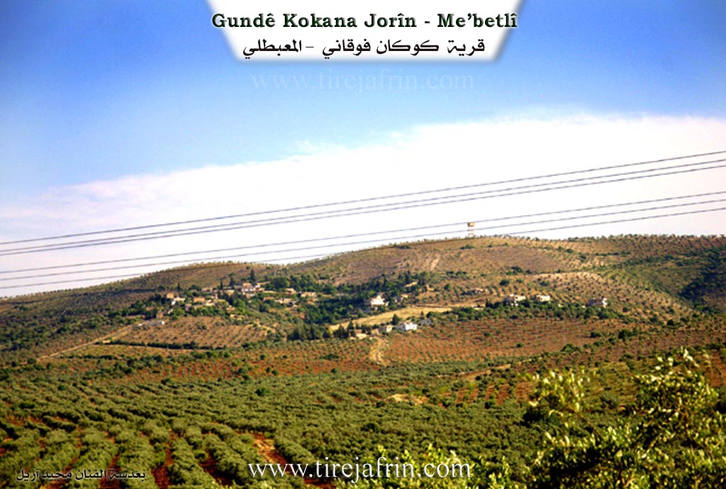
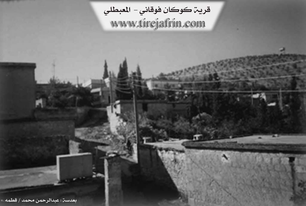
It is stated in the book جبل الكرد (عفرين) دراسة جغرافية Çiyayê Kurmênc (Efrîn): A Geographical Study by د. محمد عبدو علي Dr. Mihemed Ebdo Elî: Kokan, Cezrûniye / 2082 inhabitants - 865 houses /:
The literal Kurdish meaning of the name is: Kok means tree trunk or root, and an is a sign indicating the plural case in Kurdish. They are two villages, Upper and Lower: Kokan Jorîn, Upper Kokan, Upper Cezrûniye / 8km - 440m /.
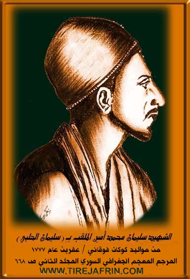
It is the older village, and it is the birthplace of Silêmanê Helebî (Suleiman al-Halabi), who assassinated General Kléber, the successor of Napoleon in his campaign against Egypt in the year 1800. Its location is near the summit of the northern slope of a plateau, some parts of which are covered by oak forests.
It is stated in the book عفرين .... نهرها وروابيها الخضراء Efrîn... Her River and Her Green Hills by the writer عبدالرحمن محمد Ebdulrehman Mihemed from the village of Qetme: Kokan Jorîn is a village in Çiyayê Kurmênc, administratively belonging to the district of Mabeta, region of Efrîn, province of Heleb. It is a small village located in the middle part of the mentioned mountain on the southern slope of Çiyayê Hawarî on a mountainous elevation and a very steep slope. Its soil is clay. It is 12km away from the town of Mabeta toward the northwest.
It is bordered to the north by a high mountainous elevation and the village of Oksûzlî. To the south, it is bordered by a slope, the fertile Deşta Kitix (Kitix plain), the Riya Reco-Efrîn (Reco-Efrîn road), the Xeta Trênê (railway line), and the villages of Qitranlî and Ereb Uşaxî. To the west, it is bordered by a slope, Newala Tîra (Tîra valley), the railway, and the villages of Hemşilê and Behdîna. To the east, it is bordered by a slope, a plain, and the village of Heyatê.
The number of its houses is about 25, and its age is approximately 150 years. Its old dwellings are made of stone and mud with wooden roofs, while the modern ones are concrete, spreading eastward and southward, except for the northern side which is high and mountainous. An electricity network is available, as well as a water network connected to a well south of the mentioned village.
Its residents work in rainfed agriculture on 250 hectares (grains, olives, vines, almonds) and irrigated agriculture from artesian wells for summer vegetables and fruit trees (walnuts, almonds, apricots, cherries). The village is surrounded by trees from all sides, and in front of it is the open plain overlooking the fertile Deşta Kitix.
Among its most important families is the Kîlo family (they were the first to inhabit the village). Also among the families present in the village are: the Hemo family / grandchildren of the hero Silêman Ows Qûbar = Silêmanê Helebî /, the Ebdo Horo family, and the Celha family.
Among the social figures are the village mukhtar Mihemed Mistefa Hemo, Ebdo Yûsif Hemo, and Mihemed Omer Murad.
Village Mukhtar: Mihemed Hemo Mistefa
Sources:
- Book: جبل الكرد (عفرين) دراسة جغرافية Çiyayê Kurmênc (Efrîn): A Geographical Study by د. محمد عبدو علي Dr. Mihemed Ebdo Elî.
- Book: عفرين .... نهرها وروابيها الخضراء Efrîn... Her River and Her Green Hills by عبدالرحمن محمد Ebdulrehman Mihemed from the village of Qetme.
Preparation and execution: Director of Tirej Efrîn site: Ebdulrehman Hacî Osman 20/12/2013.
II. Summary of Kokanê Jêrin and Kokanê Jorin from Ax û Welat
Source: https://www.youtube.com/watch?v=Uwpv8OPHzNA
The area known as Kûkanê in the Mabata district of Efrîn consists of two distinct settlements: Kûkana Jor (Upper) and Kûkana Jêr (Lower). The name is derived from Kûka Kaniyê, referring to the geographical "hollow" of a mountain spring that defined the original site. Kûkana Jor, situated on the hill Sirtê Bêrê, is the older of the two, with oral history suggesting it was founded approximately 700 years ago, though specific records mentioned by elders cite the year 1733. Kûkana Jêr is a younger settlement, established roughly 100 years ago near the historic ruins of Xerabê Dêle, a site featuring over 20 ancient cisterns and caves indicative of a much older town.
The social structure of the villages is defined by specific tribal and family lineages. Kûkana Jor is inhabited primarily by the Şêxiyan and Heseniyan tribes, housing families such as Oskoper, Evdê Horê, Cilha, Xelîce, and Hecçenan. Kûkana Jêr is historically linked to the Rûbariyan tribe. Its foundation is attributed to the Berket family, who migrated from the village of Bênê in the Şêrawa district due to social conflicts. Other families in the lower village include Meşikan and Mam Şemka, with the Cilha family having a presence in both settlements.
A significant historical figure from Kûkana Jor is Silêmanê Helebî (born Mihemed Emîn in 1777). He traveled to Misr (Egypt) to study at Ezher and is famous for assassinating the French General Kléber in 1801. Local history recounts that following this event, the French bombarded the village, forcing the residents of Kûkana Jor into exile for three years. While he is often claimed as an Arab hero in regional narratives, the villagers maintain a distinct memory of his Kurdish origins and the location of his family home.
The geography of Kûkanê is rich with water sources and natural landmarks that serve as community hubs. The most prominent is Kaniya Kûkanê, along with others like Kaniya Ereban and Kaniya Fatu. The area is fed by the waters of Zrafkê and Kitix, which historically supported lush gardens and poplar trees, though these have largely been replaced by olive and pomegranate groves. The landscape is defined by valleys such as Geliyê Avgirê, Geliyê Qopera, and Geliyê Şikeftxulî, and the rock formation Zinarê Iniyê. Culturally, the village preserves its heritage through individuals like Ziwêr, who maintains a collection of traditional agricultural tools like the Cercer (threshing tool) and stone Me'ser (molasses presses), and through local artists like Sizda Muhemed and Tîrana Abdo.
II. Summary of Kokanê Jorin and Kokanê Jêrin from Afrin 366
Source: https://www.youtube.com/watch?v=riSYuMjc8-Q
The village of Kûkanê is situated in the Mabatê district and is divided into two distinct sections known as Kûkanê jêr and Kûkanê jûr. Residents describe the location as having a deep history that spans several centuries. While the upper settlement was established approximately one hundred years ago, the original site known as Kûkan a qedîm is believed to be much older. Elders estimate the history of the location dates back five hundred years to the Ottoman era. A physical testament to this long history was discovered in the form of a stone inscription at the home of the Oskopar family. This artifact bore the date 1111 Hicrî and identified the owner of the house as Osman ibn Nebir. The name of the village itself is thought to derive from Kûkê leylekê which refers to a specific bird or sound associated with the area.
The social fabric of Kûkanê is composed of several key families who have lived there for generations. The primary lineages mentioned by the villagers include Oskopar, Avdê Horê, Xelîlê Çandikê, and Mala Celha. The village has faced agricultural challenges, particularly regarding the cultivation of zeytûn trees and water scarcity, but the community maintains a strong identity. This identity is bolstered by a reputation for producing talented singers and musicians. The village is home to several well known dengbêj including Ecîb Kerîm, Kamîran Mihemed, and Mihemedê Hisên, as well as the musician Newret.
The most significant historical narrative connected to Kûkanê involves the figure of Silêman El-Helebî. Born in the village into the Oskopar family, he was the son of a merchant named Mihemed Emîn who traded goods between Efrîn and Heleb. Silêman eventually traveled to Misr to study at Ezher. During the French occupation of Egypt, he became involved in the resistance and assassinated General Kléber in a garden in Cairo. Villagers recount that Silêman was subsequently executed by the French authorities at Tel el-Aqarib in the year 1800. His skull was taken to Fransa where it remains in a museum to this day. Due to this connection, some of the village lands were historically referred to as Milkê Helebî.
II. Summary of Kokanê Jorin from Khalil Sino
Source: https://www.youtube.com/watch?v=SKR8MH7FKy8
The village of Kûkanê Jor is situated in the Sewran plain of the Efrîn region, historically part of Çiyayê Kurmênc. According to local elders, the village foundation dates back approximately 400 to 500 years. Residents recount that before the construction of the current stone houses, the ancestors lived in caves in the surrounding area. The name Kûkan is believed to be derived from Koka Kaniyê, meaning the source or root of a spring that once flowed in the area. The settlement eventually expanded and split, leading to the establishment of Kûkanê Jêr roughly 100 to 110 years ago by residents moving down from the upper village.
The social structure of Kûkanê Jor consists of several specific families rather than a single tribal affiliation. The primary families mentioned as original settlers include Mala Ebdê Hûre, Mala Usê Xûbar, Mala Cilho, and Mala Xelîco. Additionally, the Mala Çêwî family migrated to the village from Çêwîna. Residents maintain strong connections with their relatives who have migrated to Heleb or abroad to countries like Almanya and Danîmark. The village built its own mosque in 1969 and a school was established in 1967, offering education up to the sixth grade.
Agriculture defines the local economy and landscape. The village is renowned for its vineyards and olive groves. Specifically, the vine cuttings known as Çilûyê Kûkanê are famous in local markets for their high quality. While the land is described as rocky and lacking abundant surface water, the villagers have historically relied on wells. A significant landmark is the Meşrûa Reîs, a major well project drilled around 1975 that once supplied water to seven surrounding villages including Dargir, Jûqê, and Omo, though it has since fallen into disrepair. Another historical site mentioned is the Delîb, which was formerly the location of a traditional olive press known as a Mehsera zeytê.
II. Ax û Walat Book 1
THE VILLAGE OF KOKANÊ
1.3.2016
There are 2 villages named Kakanê: Kokana Jorîn and Kokana Jêrîn. Both villages of Kokana Jorîn and Jêrîn are affiliated with the Mabeta district of the Efrîn canton. They are located 12 km north of the city of Efrîn and 7 km south of the town of Mabeta.
Kokana Jorîn:
Kokana Jorîn is the oldest village. The name Kokanê comes from the phrase ((Koka kaniyê)), because there was a spring at the base of the mountain in the past.
106
Kokana Jorîn is located at the base of a hill named (Sirta Bîrê), which was founded nearly 8000 years ago.
The surroundings of both villages have fields of red soil with olive trees and plants. To the north of Kokana Jorîn is the Avgirê valley, to the west are the Qopera valley and the Avgîrê valley, to the south are Sirta Golê, and to the east are the Gas Misrêf valley and the Çoqreş valley.
The people of ((Kokana Jorîn)) are from the Şêxî tribe, and the age of the village's establishment goes back 800 years. Because there was a water spring at the base of the mountain, the name ((Koka kaniyê)) was given to it, and later it became the name of the village.
There are 4 families in the village:
The family of Osqûper, Evdê Horê, Cilha, and the family of Xelîçe. Each family came from a different place, but most of them are from the Hesnî tribe.
There are nearly 90 houses and around 1200 people in the village of Kokana Jorîn.
It is worth mentioning that a person named (Silêman Helebî) from the village of Kokana Jorîn is the person who killed the French general Klêper in Egypt in the year 1831. Therefore, among the Arabs, he is known as a national hero, and many neighborhoods, schools, and places have been named after him.
107
It is said that during the French era, the people of Kokana Jorîn were expelled from the village for 3 years because of the killing of General Klêper, after which the French shelled the village.
Kokana Jêrîn:
Kokana Jêrîn, which is known by the name (Rûbarî), also means the (Rûbariya) tribe, which is the foundation of the family of that village. That is, the people of the village of Kokana Jêrîn are from the village of Bênê in the Şêrewa district. They came and settled in this area due to social problems.
There are 4 families in the village:
The family of Berekêt, Osqûper, Cilhê, and the family of Memşenka.
108
Most of the villagers are from the Rûbarî tribe and settled in this area nearly 100 years ago.
Kokana Jêrîn was built on a site named (Xirabî Delê), which is known as a historical site. There are more than 20 cisterns and caves in Xirabî Delê. It appears that there was an ancient city here in the olden days.
To the south are the (Kortê Şêx Mendik) valley and Kokana Jorîn, to the east is the (Şiketqulê) valley, to the west are (Zewra Kokanê), and to the north are the Reco Road and the village of Omo, as well as the Kokanê spring, where Zinarê Eniyê is also located.
From the north, the (Ziravkê) water flows and never stops, and it is known as a place of fun and recreation by the people of the region.
In Kokana Jêrîn, there are only about 45 houses and 400 people living there.
The residents of both villages make their living from agriculture, primarily from olive, grape, pomegranate, and almond trees. Along with agriculture, there are a filter factory, a hookah factory, and an olive press in the village, where many people work and support their families. Also, nearly 50 people go to the city of Efrîn daily to work in various factories and in the institutions of the Autonomous Administration.
109
There are 10 martyrs from both villages who were martyred in the Freedom Revolution, they are:
Rifet, Nûbihar, Qehreman, Salar, Mêrzû, Zinar, Cûdî, Xemgîn, Sozdar, and Ferhan.
There is a shrine between the villages of Kokanê and the village of Coqê, and people traditionally visit it for illnesses.
The level of intellectuals in both villages is high, and around 50 people have obtained university degrees in various fields.
Transcriptions and Subtitles
| Source | Video | Subtitles | Transcript |
|---|---|---|---|
| Khalil Sino 1 | Watch Video | Download SRT | View Transcript |
| Afrin 366 1 | Watch Video | Download SRT | View Transcript |
| Ax û Welat 1 | Watch Video | Download SRT | View Transcript |
Foundation/Origin Information of Kokanê Jorin
It is the older of the two Kokanê villages. The Kilo family were the first to inhabit the village.
Source: TirejAfrin Site
Established on a hill called Sirtabêrê. Historically, the village was comprised of a single family that separated into several distinct clans during the 20th century.
Source: Ax û Walat Transcript
Possible Village Name Meaning of Kokanê Jorin
"Kok" means tree stump or root in Kurdish.
Source: TirejAfrin Site
The name "Kûkanê" is derived from the Kurdish phrase "koka kaniyê," meaning "the source of the spring."
Source: Ax û Walat Transcript
V. Links
- Tirej Afrin:
https://www.tirejafrin.com/site/kura%20afrin%20%20%20mebetli%20-%20kokane%20jorin.htm - Ax û Welat:
https://www.youtube.com/watch?v=F31Qn8veP0I - Video:
https://www.youtube.com/watch?v=NT8k_sZWPpw - Link:
https://www.youtube.com/watch?v=Uwpv8OPHzNA - Afrin 366:
https://www.youtube.com/watch?v=riSYuMjc8-Q - Khalil Sino:
https://www.youtube.com/watch?v=SKR8MH7FKy8