General Information
Nahiya (Subdistrict)
Reco
Also Known As
Al-Taqiyah, Komreş, Kum Reşê, Kumraşê, Kumreşê, Kûrê Reş, الطاقية, كمراش, كُمْرَش, الطاقية
Families, Clans, etc.
Ebdkê Hemed, Hasko, Hesko, Kûrê Ehmed, Zozan

Photos
Basic Information about Kum Reşê
Source: Afrin Flo
Etymology: Derived from Konê Reş, meaning Black Tent
Hills: Delîb, Biniyê Xênê
Shrines: Berzîyaret
Trees: Dara Sicê, Kevndar
Wells: Bîra gund
Other Landmarks: Nav Rişê, Kevirê Reş
Summaries
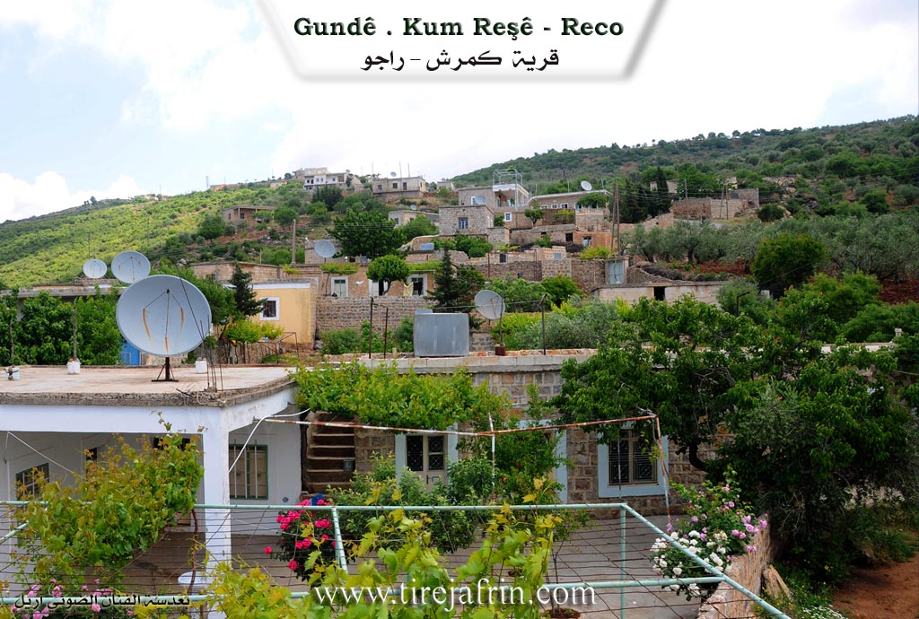
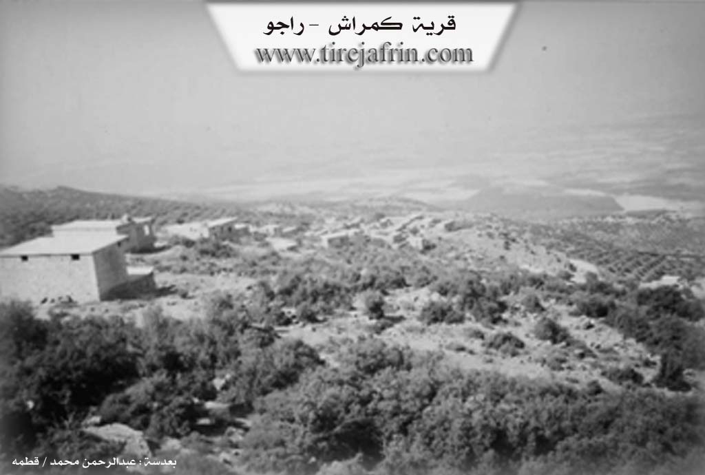
I. Summary from TirejAfrin Site (English) of Kum Reşê
Source: https://www.tirejafrin.com/site/kura%20afrin%20%20%20Reco%20-%20kum%20resh.htm
It is stated in the book جبل الكرد (عفرين) دراسة جغرافية Çiyayê Kurmênc (Efrîn): A Geographical Study: Kumreş, meaning "The Cap" / 695 inhabitants - 5km - 760m /:
Kumreş: Means "The Black Cap" (kum + reş).
It is a small village located on the western slopes of the Etmana mountain massif. It overlooks Deşta Amûqê (Amq Plain) to the west. Its location is forested, mountainous, steep, and possesses picturesque nature.
It is stated in the book عفرين .... نهرها وروابيها الخضراء Efrîn... Her River and Her Green Hills: Kumreş is a village in Çiyayê Kurmênc (Mountain of the Kurds) that follows the Reco district, Efrîn area, Aleppo governorate. It is a small village located in the central part of Çiyayê Kurmênc, on the western slope of a steep limestone height called Ne'na'e. It overlooks the lands of Deşta Amûqê to the west, and its soil is clay. It is 7 km away from the town of Reco towards the southwest.
It is bounded to the north by a harsh rugged slope, a deep watercourse, and the village of Girê; to the south by a rugged mountain chain planted with oak trees and the village of Omer Uşaxî; to the west by a very harsh slope planted with forest trees such as oak and terebinth, a deep valley, and the village of Şadiyanlî in the far west; and to the east, at a distance of 500 m, is the village of Hesen Kelkawî.
The number of its houses is about 35 houses, and its age, according to the account of one of the elderly residents, is 350 years; it is one of the old villages in the region. The village is divided into two sections: (Southern and Northern), separated by a winding watercourse. Its old dwellings are made of stone and mud with flat wooden roofs, while modern ones made of cement have spread in the southern and western sides. An electricity network and a primary school are available in the village. The village drinks from cistern water where rainwater is collected in winter.
The residents work in rain-fed agriculture (olives, grains, legumes) on an area amounting to 415 hectares, and irrigated agriculture from the waters of Çemê Reş (Black River) in the Qere Taş plain (cotton, vegetables, sunflowers, fruit trees) on a small area amounting to 15 hectares. They also work in raising sheep and goats. It is connected to the district center by a dirt road. The farms of (Tel Kişûr _ Sûrk _ Girê) follow it. Among its most important families is Hesko.
Village Mukhtar: Mihemed Hemo Husên
Sources of Information:
- Book: جبل الكرد (عفرين) دراسة جغرافية Çiyayê Kurmênc (Efrîn): A Geographical Study by د. محمد عبدو علي Dr. Mihemed Ebdo Elî.
- Book: عفرين .... نهرها وروابيها الخضراء Efrîn... Her River and Her Green Hills by عبدالرحمن محمد Ebdulrehman Mihemed from the village of Qetme.
- Studies of Navenda Tirej Soft / Ebdulrehman Hacî Osman.
- Some residents of the villages.
Preparation and execution: Director of the Tirej Efrîn site: Ebdulrehman Hacî Osman 20/12/2013
II. Summary of Kum Reşê from Afrin Flo
Source: https://www.youtube.com/watch?v=_JUweItXgvc
The village of Kumreş, occasionally referred to as Qumraş, is situated in the Reco district of the Afrin region, approximately seven kilometers from the town of Reco itself. According to local oral history, the name of the village possesses a descriptive etymology. Elders explain that the settlement was originally called Konê Reş, which translates to "Black Tent." This name stemmed from the time when the ancestors of the current residents pitched black tents in the area before permanent stone structures were built. Over time, the pronunciation shifted from Konê Reş to the current Kumreş.
Geographically, the village is split into two distinct sections: the Upper Village and the Lower Village. These two parts are physically separated by a rocky, elevated natural feature known as Delîb. This area serves as a central landmark, and residents identify specific stones there, such as the Kevirê Reş, which mark the boundary between the upper and lower sections. Another named locality within the village terrain is Biniyê Xênê. While there is no running water network, the community relies on a communal well known as Bîra gund, which is used for both domestic needs and watering livestock.
The history of Kumreş is deeply connected to its natural heritage and sacred sites. The village contains an ancient tree called Kevndar, which residents estimate to be between 200 and 250 years old. This tree is located in an area historically known as Berzîyaret, a name indicating it was once considered a shrine or a place of visitation, though the specific religious practices associated with it are attributed to previous generations. Additionally, a tree known as Dara Sicê stands near the village graves.
Socially, Kumreş consists of approximately 50 to 55 households. The transcript identifies several specific family lines, most notably Mala Hasko. One senior resident, Mihemed Hesen Hasko, details his lineage and shares personal history regarding his time as a merchant trading livestock in regional centers like Reqa, Bab, and Heleb. Other families mentioned include Mala Ebdkê Hemed, Mala Kûrê Ehmed, and the Zozan family. Historically, the residents were connected to the broader local economy through a marketplace at Nav Rişê, where they would purchase household goods such as large clay jars used for storage. Today, the villagers continue to engage in agriculture, specifically olive cultivation and livestock rearing, despite challenges related to water scarcity.
II. Ax û Walat Book 1
VILLAGE OF KUMREŞÊ
29.3.2016
The village of Kumreşê is affiliated with the Reco district of the Efrîn canton, located 7 km south of the city of Reco and 5 km near the border of northern Kurdistan.
The name of the village comes from the meaning (Konê reş) [Black Tent], as the first person who settled in the village initially lived in a black tent, and later the name became (Kumreş).
The village of Kumreşê consists of 2 parts: Upper Kumreşa and Lower Kumreşa. It is said that the ancestors of the village owned sheep and lived in tents like nomads.
There were 3 brothers; one of them was in this area, one had settled in the village of Hesen, and the other in the village of Hecîka. This means that the inhabitants of all three villages are from one family, and they are from the Şêxî tribe.
The village of Kumreşê was built on the slope of Mount (Êmînê); this mountain starts as a chain from the village of Me’mila and ends at the village of Şediya. A special feature of this mountain is that it is treeless; only thistles and solid rocks are on it.
Kumreşê, along with the village of Hesen, is to the east, Kurê to the north, Şediya to the west, and Mount Gewir or Toros to the north of the border.
The altitude of the village and its location opposite Mount Gewir, which is snowy until the beginning of summer, has caused the weather to be cold in winter and spring and cool and pleasant in summer.
A valley starts from the village of Hesen, dividing the village of Kumreşê from top to bottom into two parts. There are many valleys and ravines around the village; Geliyê Kumreşê to the north, Geliyê Hisên to the south, and Geliyê Ne’nê to the west.
This region is also famous for its mountains; to the north are Mount (Benê) or (Pozê Zêtûnê) and (Benê Gêwir), to the east are Mount (Eniya Kirêcê) and (Kaşê Biliş).
At the bottom of the village, to the north, lies (Deşta Şediya), which is adorned with olive trees and has a richness of red soil and an abundance of water, so the villagers plant many vegetable fields there.
In Upper Kumreşa, there are 4 families:
The family of Berî, Evdikê Hemedê, Şimil, and the family of Heskê, and all are from one family.
In Lower Kumreşa, there are also 3 families:
The family of Bîbê, Evdileh, and the family of Mihê Êmiş.
About 60 houses and around 400 people live in both parts of the village.
*The people of the village make their living from agriculture, and the care of olive groves is at the forefront. Along with them, the villagers also plant vegetable and fruit gardens such as watermelon, melon, eggplant, cucumber, and also grains like barley, wheat, chickpeas, and lentils.
Along with agriculture, some families own livestock such as sheep and goats, and they sell their products like milk, cheese, and yogurt in the markets of Reco and Efrîn.
Some young people from the village also work in sewing workshops in the city of Reco and some in other workshops, and they support their families with it.
There are many water wells that were dug by human hands in the past, and one of those wells is between the two parts of the village, from which the villagers get their drinking water. The well (Zêtûnkê) is to the south of the village, and shepherds water their flocks at it. The well (Eso) is about 2 km south of the village, and the villagers have drawn water through pipes to their cisterns.
There is a stone mill in the village, and to this day, the villagers use it for grinding bulgur (sevar).
There is a primary school in the village, and the village children study there up to the sixth grade.
There is a martyr named (Ş. Qehreman) who was martyred in the National Liberation War. It is worth mentioning that he is the first martyr whose body was transferred from northern Kurdistan to Rojava, and he is now buried in the Reco cemetery.
The village commune has been named Ş. Çekdar and provides services to the village and also organizes the lives of the villagers.
Because the village is near the northern border, many relatives of the villagers live in the villages across the border, such as: Qirixanê, Kor Xelîl.
There is a shrine in the village named (Erdikê Elê), and in the past, villagers would visit it at the new year for rain, and sometimes people would visit it for the treatment of illnesses.
Many families from the village of Kumreşê have settled in the city of Reco, where they continue their work and life.
Recently, a benefactor built a mosque in the village. Villagers go there for prayer, and on Fridays and holidays, the young men and men of the village gather there to listen to the sermon of the mullah and celebrate their holiday.
Transcriptions and Subtitles
| Source | Video | Subtitles | Transcript |
|---|---|---|---|
| Afrin Flo 1 | Watch Video | Download SRT | View Transcript |
Foundation/Origin Information of Kum Reşê
It is one of the old villages in the region.
Source: TirejAfrin Site
The original village was established by ancestors at a different site; the current settlement is newer. The community is composed of the Hamou and Haske families (Rashwan tribe), and the Abdillah family (Dimli tribe).
Source: Afrin 366 Transcript
Possible Village Name Meaning of Kum Reşê
"Kum reş" means "the black cap" in Kurdish.
Source: TirejAfrin Site
Originally named 'Kûrê Reş' after a deep, black well in the valley before its name was later changed.
Source: Afrin Flo Transcript
Potentially from the Kurdish 'Kom Rash' (black gathering) due to the area's dark stones, though a Roman origin is also suggested.
Source: Afrin 366 Transcript