General Information
Nahiya (Subdistrict)
Mabeta
Also Known As
Al-Zahirah al-Tahtaniyah, Korke Jêr, Kurka Jêrin, Kurka Jêrîn, Kurkan Tahtani, Kurkê Jêrin, الظاهرة التحتانية, كوركان تحتاني, كوركه جيرن
Tribes
Berazî, Nêimî, Rûbarî
Families, Clans, etc.
Hemo Bizirke, Mala 'Elî Têne, Mala Altona, Mala Becet, Mala Bekrî Hemçîçê, Mala Ebdikê, Mala Eltûne, Mala Elî Şêrvên, Mala Eynê, Mala Hekîm, Mala Hemçûçê, Mala Hemîtê, Mala Kurê Ehmedo, Mala Opîrê, Mala Orgîta, Mala Têwedê, Mala Çapûk, Mala Çewê, Malê Bozo, Malê Heso, Neşetê Omer, Qerqol Axê, Xelîl Hecî Misto, Şukrî Hemîd Kîlo

Photos
Basic Information about Kurkê Jêrin
Source: Ax û Welat (Information for Kurkê Jêrin and Kurkê Jorin)
Etymology: Named Kurka (meaning sons/boys) after two brothers who founded the settlements; one settled in Kurka Jêrîn (Lower) and the other in Kurka Jorîn (Upper). Alternatively linked to 'ava bedewî' (beautiful water).
Foundation Date/Period: More than 600 years ago
Springs: Kaniya Dehabav
Shrines: Ziyareta Mîra, Serdangaha Mora
Ruins: Xerabe Temirciya
Other Landmarks: Gola Kurka, Ser Şikefta, Geliye Rşiyê, Geliye Hûpa, Geliye Dora, Geliye Sahrîncê, Curnê bin Daran, Curnê Kolê, Curnê Kêrtê, Curnê Tehtê
Source: Afrin 366 (Information for Kurkê Jêrin and Kurkê Jorin)
Etymology: According to local oral history, the name Kirkê is derived from the word 'qicik' meaning small, potentially referring to the founder or the initial size of the settlement
Shrines: Mazal Cema'a
Ruins: Me'ser
Other Landmarks: Sêwiya, Berbenê, Gûliya, Ba'dîno, Dimila, Qidê
Source: Khalil Sino
Etymology: Derived from the word "Kirik" meaning "boy" (lawik); oral tradition suggests two boys settled there, leading to the name Kirko, eventually divided into Kirkê Jêr (Lower) and Kirkê Jûr (Upper)
Shrines: Meqbeza Mele Şikrî Heyder, Zîyareta Şêx Hisên
Summaries
I. Summary from TirejAfrin Site (English) of Kurkê Jêrin
Source: https://www.tirejafrin.com/site/kura%20afrin%20%20%20mebetli%20-%20kurke%20jerin.htm
It is stated in the book جبل الكرد (عفرين) دراسة جغرافية Çiyayê Kurmênc (Efrîn): A Geographical Study by د. محمد عبدو علي Dr. Mihemed Ebdo Elî: Kurka, Kurkan: The abstract noun Kurk means a brooding hen. If pronounced as Kurik, it means small sons or youths whose beards have not yet grown. However, if its root is Kur, it means the small barren hill or highland. This latter meaning is the origin of the name, as the two villages are located on two small hills that were historically devoid of trees. The Arabizers relied on this interpretation and translated the name to Al Zahira (meaning The Phenomenon or The Visible Feature).
They are two villages: Kurka Jorîn (Upper Kurka) and Kurka Jêrîn (Lower Kurka).
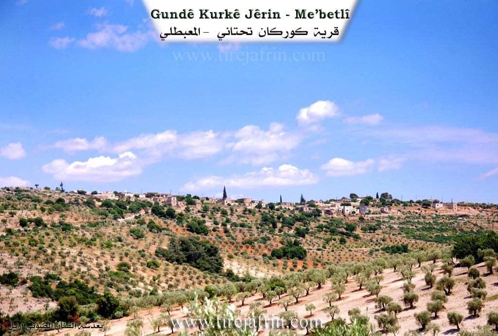
Kurka Jêrîn, Kurkan Tahtanî, Al Zahira Al Tahtaniya /932 inhabitants, 134 hectares, 14km distance, 550m altitude/: It is a small village located on the northern slope of a limestone height.
It is stated in the book عفرين .... نهرها وروابيها الخضراء Efrîn... Her River and Her Green Hills by the writer عبدالرحمن محمد Ebdulrehman Mihemed from the village of Qetme: Kurkan Tahtanî is a village in Çiyayê Kurmênc, administratively belonging to the Mabeta district, Efrîn region, Heleb governorate. It is a small village situated in the middle section of the mentioned mountain, on the northern slope of the limestone Çiyayê Hemo. It overlooks the agricultural plains of the Kitix plain to the east. It is located to the northwest of the town of Mabeta at a distance of 14km.
It is bordered to the north by a slope, Newala Sîlê (Sili valley), and the village of Dombilî; to the south by a mountainous height and the nearby village of Sariya; to the west by Newala Sîlê, mountainous heights planted with olive trees, and the village of Memila; and to the east by Newala Sîlê, the Kitix plains, the village of Kelîbo, and Kurka Jorîn.
The number of its houses is about 35 houses, and its age is approximately 350 years. Its old houses are made of stone and mud with wooden ceilings, while modern concrete buildings are spreading in the south and west. An electricity network is available, as well as a drinking water network connected to an artesian well in the west of the village. It contains a primary school and an olive press. A paved mountain road connects it to the district center.
Its residents practice rain fed farming over an area of 134 hectares, cultivating grains and olive trees, especially on the mountain slopes in the west and north of the village, alongside raising sheep and goats. Among its most important families are: the Hemo Bizirke family, the Xelîl Hecî Misto family, and the Şukrî Hemîd Kîlo family.
The village Mukhtar: Zimriya Osman.
Preparation and execution:
Manager of Tirej Efrîn site: Ebdulrehman Hacî Osman
20/12/2013
Sources:
- Book: جبل الكرد (عفرين) دراسة جغرافية Çiyayê Kurmênc (Efrîn): A Geographical Study by د. محمد عبدو علي Dr. Mihemed Ebdo Elî.
- Book: عفرين .... نهرها وروابيها الخضراء Efrîn... Her River and Her Green Hills by عبدالرحمن محمد Ebdulrehman Mihemed from the village of Qetme.
II. Summary of Kurkê Jêrin and Kurkê Jorin from Ax û Welat
Source: https://www.youtube.com/watch?v=ikTuzI6TJgY
The village of Kurkê Jêrîn (Lower Kurka) is a historical settlement located in the Mabeta district of Afrin (Çiyayê Kurmênc). Situated approximately 22 kilometers north of Afrin city, the village shares a deep connection with its twin village, Kurkê Jorîn (Upper Kurka). According to oral history and local elders, the village was founded over 600 years ago. The name "Kurka" is believed to originate from the Kurdish word for "sons" (kur), referring to two brothers who originally settled the area; one established the lower village while the other moved to the upper site. Another interpretation suggests the name reflects the abundance of "beautiful water" in the region, which historically flowed from Qûpê down to Hecû.
The village's social fabric is woven from various waves of migration and settlement. The founding lineage is identified as Mala Hemîtê (descendants of Mala Hekîm). However, a tragic event involving the death of a child who fell from a tree caused this original family to burn their property and leave the village entirely. Subsequently, other families arrived to repopulate the area. Mala Altona migrated from Deşta Hemqê, followed by Mala Hemçûçê. Later, Mala Kurê Ehmedo arrived from Ba'dîna, notably led by Mehemed Agha, who established an olive press in the village around 1865. Other notable families include Mala Orgîta (from south of Dimîliya), Mala Ebdikê and Mala Elî Şêrvên (both from Kobaniyê and associated with the Nêimî tribe), and Mala Eynê.
Kurkê Jêrîn is also known for a significant historical relationship with the Armenian community. Following the events of 1915, Armenian survivors settled in an area of the village now known as Xerabe Temirciya (Ruins of the Blacksmiths). They lived in caves and built structures, providing essential ironworking services to the villagers. Relations were harmonious, leading to intermarriage, such as the union between a villager named Sultan and an Armenian woman. Most Armenian residents eventually moved to Aleppo or Efrîn, but their legacy remains in the ruins and oral histories.
The landscape around Kurkê Jêrîn features several named landmarks and water sources, including the spring Kaniya Dehabav and the pond Gola Kurka. Valleys such as Geliye Rşiyê, Geliye Hûpa, and Geliye Sahrîncê channel water through the terrain. The village is home to sacred sites like Ziyareta Mîra (also referred to as Serdangaha Mora), which contains two wells. Culturally, the village has produced figures like the renowned tambur player Necîb Mihemed Hebeş, who accompanied the artist Mihemed Elî Tecû. In recent times, the village has honored martyrs such as Şehîd Dilşêr and Şehîd Cîhad, naming local institutions after them.
II. Summary of Kurkê Jêrin and Kurkê Jorin from Afrin 366
Source: https://www.youtube.com/watch?v=TIx0FNLEzE8
The village of Qerqo, also referred to locally as Kirkê, is situated in the Mabata district of the Efrîn region. The settlement is geographically and socially divided into two distinct sections known as Qerqê Jûrin or Upper Qerqo and Qerqê Jêrin or Lower Qerqo. According to an elderly resident, the village origins trace back to migrants from Kûbanî who belonged to the Berazî tribe. This elder explains that the name Kirkê is linked to the word "qicik" which implies something small, possibly referencing the founder or the modest scale of the original hamlet. While the exact foundation date is lost to time, the presence of ancient stone houses and oral history regarding ancestors suggests a presence spanning many generations.
The social structure of Qerqo is defined by several prominent lineages distributed between the two sections. In the upper village, the Malê Bozo and Malê Heso are cited as foundational families, alongside Mala Becet. The lower village is home to families such as Mala Bekrî Hemçîçê, Mala Çapûk, Mala Eltûne, and Mala 'Elî Têne. Additionally, the lineage of Qerqol Axê is noted as a significant origin point for a specific household. Historically, the village was substantial, with the host estimating around 100 households in the upper section and 75 in the lower. However, migration has severely impacted the population, with one elder noting that only a few families remain permanently in the upper section.
Notable landmarks in Qerqo reflect its agricultural and spiritual life. The village contains a site known as Mazal Cema'a, which serves as the cemetery and a place of reverence for the deceased. Economically, the village is deeply rooted in olive cultivation. This is evidenced by the presence of a historic olive press known as the Me'ser, which residents view as a piece of heritage, contrasting with a modern industrial press recently built for the community. The village is also closely linked to neighboring settlements like Ba'dîno, Sêwiya, Berbenê, Gûliya, Dimila, and Qidê, which form the surrounding geographic context. Water scarcity is mentioned as a challenge in the upper village, leading to reliance on cisterns and neighboring resources.
II. Summary of Kurkê Jêrin from Khalil Sino
Source: https://www.youtube.com/watch?v=S07YIFtXBvk
The village of Kirkê Jêr, also referred to as Qerqî Jêr by some residents, is located in the Afrin region, approximately six kilometers from the sub-district of Mabeta. According to the village elder Mistefa, the history of the settlement is ancient. He explains that the name originates from the Kurmanji word "Kirik," meaning "boy." Local legend holds that two boys originally arrived and settled in the area, leading to the designation Kirko, which eventually split into two distinct settlements: Kirkê Jêr (Lower Kirk) and the neighboring Kirkê Jûr (Upper Kirk).
The social history of the village is preserved through the memories of its elders. Mistefa, who is eighty years old, recalls a childhood defined by hardship, where men worked as laborers in the Cûmê plain. He shares a personal anecdote about accidentally burning a sheaf of green wheat ("frîk") with his brother Hesen while their father was away working. The village population includes residents who married into the community from surrounding areas; for instance, Fîdan recounts how she was brought to Kirkê Jêr from the village of Qidê roughly fifty or sixty years ago via a traditional "revand" (elopement/abduction) on a horse, which her husband Bavê Azad jokingly remembers as red rather than the romanticized white.
Religious and historical life centers around the village cemetery, which residents estimate to be around two hundred years old. Notable sites within this sacred space include the Meqbeza Mele Şikrî Heyder and the family burial plot of Mala Çewê. The cemetery is shared with the neighboring Kirkê Jûr. Additionally, the Zîyareta Şêx Hisên is a significant shrine located nearby; although the shrine is historically associated with Kirkê Jûr, it serves as a spiritual landmark for the area.
In terms of modern history and infrastructure, the village formerly hosted a bakery (Firne) established in the 1980s that served not only Kirkê Jêr but also neighboring villages like Habûyê and Alîkanê. However, this bakery has been closed for decades, and residents now rely on bread brought from Ba'dîna. The village currently contains one primary school. A notable contemporary figure in the village is Nûrî, who claims to have discovered an herbal remedy for cancer using a specific root found in the wilderness, which he processes and distributes freely to the sick as an act of charity.
II. Ax û Walat Book 2
KURKA JÊRÎN
25.10.2017
[Image of the village of Kurka Jêrîn]
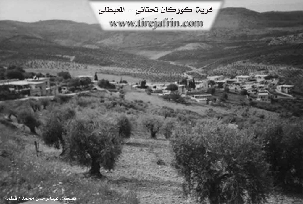
The village of Kurka Jêrîn is affiliated with the Mabeta district of the Efrîn canton, located 7 km northwest of the town of Mabeta and 22 km north of the city of Efrîn.
The village of Kurka was established in a region known by the name (Kurka), which is an area that ends from the villages of Qopê in the north to the village of Hebo in the southwest, hence the village's name became ((Kurka)).
Initially, there were 2 brothers; one settled in the village of Kurka Jorîn and the other settled in Kurka Jêrîn, and each one populated a village.
The village of Kurka Jêrîn is an ancient village. It is said that a person named ((Hemîtê)) from the descendants of the first family was the one who
44
had founded the village, but he moved from there to an unknown place due to the death of his son. Now, no one from that family is in the village.
There are 7 families in the village:
It is worth mentioning that all the families of the village have come from different areas, among them:
The Hemçûçê family came from Şengal, Eltan came from the Gewir mountain region, Argîta came from the south of Dimiliya, Kor Ehmedo from the village of Be’dîna from the Şêxî tribe came in 1865, Evdîk from the Niêmî tribe came from Kobanê, Elî Elikê came from the village of Bênê 80 years ago, and the Têwit family came from the village of Pêrşênê across the border near the village of Qermîtliq.
75 houses and around 1000 people live in the village; now some families have moved abroad and some have settled in the city of Efrîn.
To the east of the village are the olive groves named Ser Şikefta; to the south, the villages of Sariya, Kurka Jorîn, and the road to Efrîn; to the west, Rêşiya with its rocks, the Ekarê valley, and the Serê Kol field; and to the north, the Hopa valley and the village of Dimiliya. To the west of the village, the Kurka lake, like a pool of water, would collect, and sheep were watered from it. To the southeast of the village lies the Mûrad shrine, where there are two water wells.
The Dirûmiyê Cemetery is to the east of the village. It used to be the cemetery for 9 villages.
After the Armenian genocide during the First World War, one of the men of the village married an Armenian woman,
45
and some Armenians also established a blacksmith workshop in the north of the village and were in the village for a time, then they moved to the city of Aleppo.
The inhabitants of the village, like the people of the surrounding area, make their living from the cultivation of olive trees as their main work, along with which a few families raise livestock. A modern bakery has been built in the village, where 6 people work. Nearly 10 people work in various factories in the city of Efrîn, and nearly 20 people also work in the institutions and agencies of the Autonomous Administration in Efrîn and Mabeta.
There are 2 martyrs from the village:
Martyr Dilşêr and martyr Cîhad. The village's school is named after martyr Dilşêr, and the village's commune is named after martyr Cîhad.
The Great Spring is located 3km south of the village; 9 surrounding villages used to get water from it. A person named ((Hemdiko)) opened this spring.
Heyder Axa, Mistê Ezîz, Êhê Osê Ebdîkê, Hemedê Hisînê, Xelîlê Hecî, and Şukriyê Heyder were elders and prominent figures of the village in past times; they were a place of respect and honor among the people of the village and played a significant role in resolving social problems in the village.
Necîb Mihemed Hebeş is an excellent tanbur player. He was the tanbur player for the late artist Mihemed Elî Tico. For nearly 30 years, he played the tanbur with the aforementioned artist.
46
Şukriyê Heyder provided many services to the village and gave a lot of effort and help for opening roads, bringing electricity to the village, and building the school.
It is worth mentioning that last year, in 2016, the students of the village took first place at the Mabeta district level in theater.
Transcriptions and Subtitles
| Source | Video | Subtitles | Transcript |
|---|---|---|---|
| Khalil Sino 1 | Watch Video | Download SRT | View Transcript |
| Afrin 366 1 | Watch Video | Download SRT | View Transcript |
| Ax û Welat 1 | Watch Video | Download SRT | View Transcript |
Foundation/Origin Information of Kurkê Jêrin
A 200-year-old bakery, "Meqbeze Celko," which was owned by the Şikrî Heyder and Çewo families, served a previous settlement in the area.
Source: Halil Sino Transcript
Possible Village Name Meaning of Kurkê Jêrin
"Kurk" can mean brooding hen, "Kurik" can mean small boys, but the root is likely "Kur," meaning small bare hill, which fits the location.
Source: TirejAfrin Site
The village name derives from an ancient story ("ji tarîxê kevn") about two boys ("koriko").
Source: Halil Sino Transcript
V. Links
- Tirej Afrin:
https://www.tirejafrin.com/site/kura%20afrin%20%20%20mebetli%20-%20kurke%20jerin.htm - Ax û Welat:
https://www.youtube.com/watch?v=8YsZP3s5Gg4 - Link:
https://www.youtube.com/watch?v=ikTuzI6TJgY - Afrin 366:
https://www.youtube.com/watch?v=TIx0FNLEzE8 - Khalil Sino:
https://www.youtube.com/watch?v=S07YIFtXBvk