General Information
Nahiya (Subdistrict)
Mabeta
Also Known As
Al-Zahirah al-Ulya, Kerkû Feqanî, Kurkan Foqani, Kurkê Jorin, الظاهرة العليا, كوركان فوقاني, كوركه جورن
Tribes
Berazî, Nêimî, Rûbarî
Families, Clans, etc.
Benûkûz, Beskî, Bîro, Emer Hesen, Eşkerkomo, Hes Korê, Heso, Kîle, Mala 'Elî Têne, Mala Altona, Mala Becet, Mala Bekrî Hemçîçê, Mala Ebdikê, Mala Eltûne, Mala Elî Şêrvên, Mala Eynê, Mala Hekîm, Mala Hemçûçê, Mala Hemîtê, Mala Kurê Ehmedo, Mala Opîrê, Mala Orgîta, Mala Têwedê, Mala Çapûk, Malê Bozo, Malê Heso, Mirad, Neşetê Omer, Qerqol Axê, Silêman

Photos
Basic Information about Kurkê Jorin
Source: Ax û Welat (Information for Kurkê Jêrin and Kurkê Jorin)
Etymology: Named Kurka (meaning sons/boys) after two brothers who founded the settlements; one settled in Kurka Jêrîn (Lower) and the other in Kurka Jorîn (Upper). Alternatively linked to 'ava bedewî' (beautiful water).
Foundation Date/Period: More than 600 years ago
Springs: Kaniya Dehabav
Shrines: Ziyareta Mîra, Serdangaha Mora
Ruins: Xerabe Temirciya
Other Landmarks: Gola Kurka, Ser Şikefta, Geliye Rşiyê, Geliye Hûpa, Geliye Dora, Geliye Sahrîncê, Curnê bin Daran, Curnê Kolê, Curnê Kêrtê, Curnê Tehtê
Source: Afrin 366 (Information for Kurkê Jêrin and Kurkê Jorin)
Etymology: According to local oral history, the name Kirkê is derived from the word 'qicik' meaning small, potentially referring to the founder or the initial size of the settlement
Shrines: Mazal Cema'a
Ruins: Me'ser
Other Landmarks: Sêwiya, Berbenê, Gûliya, Ba'dîno, Dimila, Qidê
Source: Khalil Sino
Shrines: Meqamê Şêx Hesen, Tirba Şêx Elî
Other Landmarks: Ceqatê, Jîqla, Çatê
Summaries
I. Summary from TirejAfrin Site (English) of Kurkê Jorin
Source: https://www.tirejafrin.com/site/kura%20afrin%20%20%20mebetli%20-%20kurke%20jorin.htm
It is stated in the book جبل الكرد (عفرين) دراسة جغرافية Çiyayê Kurmênc (Efrîn): A Geographical Study by د. محمد عبدو علي Dr. Mihemed Ebdo Elî: Kurka / Kurkan: The abstract name Kurk means a brooding hen. If pronounced in the form Kurik, it means small children or youths whose beards have not yet grown. If its root is Kur, it means the small barren one among hills or heights, and this latter meaning is the origin of the name, for the two villages are located on two small hills that were formerly barren of trees. The Arabizers relied on this and translated the name to "Al-Zahira" (The Visible/The Prominent).
They are two villages: Kurk jorin (Upper) and Kurk jêrîn (Lower).
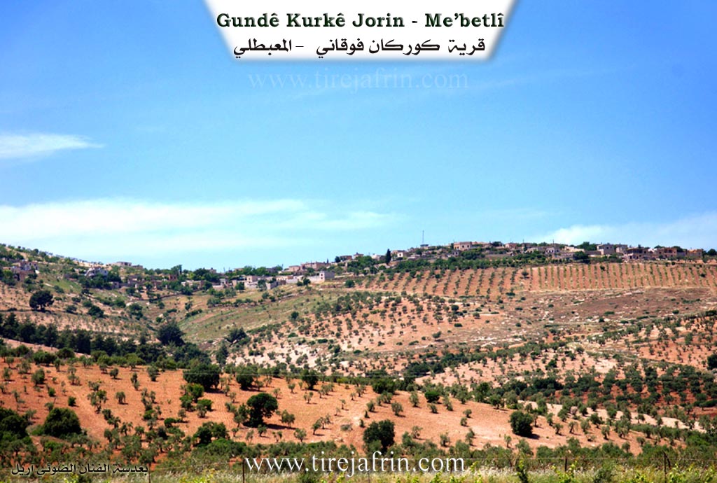
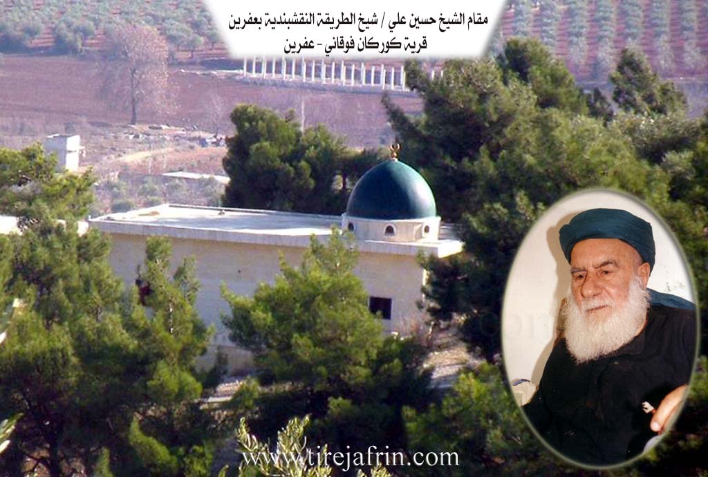
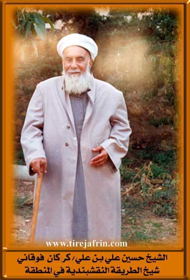
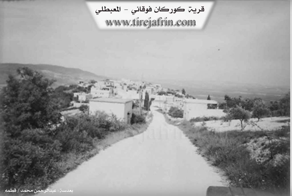
Kurk Jorin Kurkan Foqanî Al-Zahira Al-Ulya: 1397 inhabitants, 382 hectares, 13km distance, 620m elevation. It is a small village overlooking agricultural plains from its eastern side. It is the village of the Imam of the Naqshbandi order in the Efrîn region, Sheikh Hisên bîn Elî.
It is stated in the book عفرين .... نهرها وروابيها الخضراء Efrîn... Her River and Her Green Hills by the writer عبدالرحمن محمد Ebdulrehman Mihemed from the village of Qetme:
Kurkan Foqanî is a village in Çiyayê Kurmênc, administratively belonging to the Mabeta district, Efrîn area, Heleb governorate. It is a small village located in the middle section of the mentioned mountain, atop a rocky tongue connected on its western side to Çiyayê Hemo (Mount Hemo). It overlooks agricultural plains to its northeast and lies to the northwest of the town of Mabeta at a distance of 13km. Its soil is clay.
It is bordered to the north by a steep slope planted with olive trees, a torrential valley, and the village of Dumbilê. It is bordered to the south by a rugged slope planted with olive trees, several watercourses, and the village of Xaziyanlî (lower and upper). To the west, it is bordered by a mountainous height and the village of Sareuşaxî at a distance of 1km toward the west. To the east, it is bordered by a slope, the fertile plains of Kitix, the Riya Efrîn-Reco (road), and the village of Gul îbo.
The number of its houses is about 65 houses, and its age is about 300 years. Its dwellings were stone and mud with flat wooden roofs; it has developed architecturally, and modern cement dwellings have become spread within it, extending toward the south and east. An electricity network is available, as well as a water network drawn from the nearby Bîra Rehmaniyê (well). The village contains a primary school, a small mosque in the center of the village, and two presses, one of them technically modern and the other a normal modern one.
Its residents cultivate 366 hectares of rainfed land with grains, legumes, and olive trees, and they cultivate 16 hectares from artesian wells with some fruit trees, walnuts, and cherries. It is connected to the district center by a paved road that passes through its center to several villages.
Among the families present in the village:
Heso family
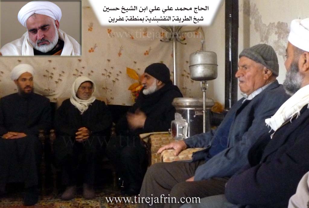
Kîle family (the family of the late Sheikh of the Naqshbandi order, the late Sheikh Hisên)
Emer Hesen family (Hes Korê)
Beskî family
Mirad family
Bîro family
Silêman family
Among the social figures in the village:
Haj Elî son of Sheikh Hisên.
Mukhtar of the village: Xelîl Mihemed Heso.
Preparation and execution:
Director of the Tirej Efrîn site: Ebdulrehman Hacî Osman
20/12/2013
Sources:
- Book: جبل الكرد (عفرين) دراسة جغرافية Çiyayê Kurmênc (Efrîn): A Geographical Study by د. محمد عبدو علي Dr. Mihemed Ebdo Elî.
- Book: عفرين .... نهرها وروابيها الخضراء Efrîn... Her River and Her Green Hills by عبدالرحمن محمد Ebdulrehman Mihemed from the village of Qetme.
- Studies of Navenda Tirej Soft / Ebdulrehman Hacî Osman.
II. Summary of Kurkê Jêrin and Kurkê Jorin from Ax û Welat
Source: https://www.youtube.com/watch?v=ikTuzI6TJgY
The village of Kurkê Jêrîn (Lower Kurka) is a historical settlement located in the Mabeta district of Afrin (Çiyayê Kurmênc). Situated approximately 22 kilometers north of Afrin city, the village shares a deep connection with its twin village, Kurkê Jorîn (Upper Kurka). According to oral history and local elders, the village was founded over 600 years ago. The name "Kurka" is believed to originate from the Kurdish word for "sons" (kur), referring to two brothers who originally settled the area; one established the lower village while the other moved to the upper site. Another interpretation suggests the name reflects the abundance of "beautiful water" in the region, which historically flowed from Qûpê down to Hecû.
The village's social fabric is woven from various waves of migration and settlement. The founding lineage is identified as Mala Hemîtê (descendants of Mala Hekîm). However, a tragic event involving the death of a child who fell from a tree caused this original family to burn their property and leave the village entirely. Subsequently, other families arrived to repopulate the area. Mala Altona migrated from Deşta Hemqê, followed by Mala Hemçûçê. Later, Mala Kurê Ehmedo arrived from Ba'dîna, notably led by Mehemed Agha, who established an olive press in the village around 1865. Other notable families include Mala Orgîta (from south of Dimîliya), Mala Ebdikê and Mala Elî Şêrvên (both from Kobaniyê and associated with the Nêimî tribe), and Mala Eynê.
Kurkê Jêrîn is also known for a significant historical relationship with the Armenian community. Following the events of 1915, Armenian survivors settled in an area of the village now known as Xerabe Temirciya (Ruins of the Blacksmiths). They lived in caves and built structures, providing essential ironworking services to the villagers. Relations were harmonious, leading to intermarriage, such as the union between a villager named Sultan and an Armenian woman. Most Armenian residents eventually moved to Aleppo or Efrîn, but their legacy remains in the ruins and oral histories.
The landscape around Kurkê Jêrîn features several named landmarks and water sources, including the spring Kaniya Dehabav and the pond Gola Kurka. Valleys such as Geliye Rşiyê, Geliye Hûpa, and Geliye Sahrîncê channel water through the terrain. The village is home to sacred sites like Ziyareta Mîra (also referred to as Serdangaha Mora), which contains two wells. Culturally, the village has produced figures like the renowned tambur player Necîb Mihemed Hebeş, who accompanied the artist Mihemed Elî Tecû. In recent times, the village has honored martyrs such as Şehîd Dilşêr and Şehîd Cîhad, naming local institutions after them.
II. Summary of Kurkê Jêrin and Kurkê Jorin from Afrin 366
Source: https://www.youtube.com/watch?v=TIx0FNLEzE8
The village of Qerqo, also referred to locally as Kirkê, is situated in the Mabata district of the Efrîn region. The settlement is geographically and socially divided into two distinct sections known as Qerqê Jûrin or Upper Qerqo and Qerqê Jêrin or Lower Qerqo. According to an elderly resident, the village origins trace back to migrants from Kûbanî who belonged to the Berazî tribe. This elder explains that the name Kirkê is linked to the word "qicik" which implies something small, possibly referencing the founder or the modest scale of the original hamlet. While the exact foundation date is lost to time, the presence of ancient stone houses and oral history regarding ancestors suggests a presence spanning many generations.
The social structure of Qerqo is defined by several prominent lineages distributed between the two sections. In the upper village, the Malê Bozo and Malê Heso are cited as foundational families, alongside Mala Becet. The lower village is home to families such as Mala Bekrî Hemçîçê, Mala Çapûk, Mala Eltûne, and Mala 'Elî Têne. Additionally, the lineage of Qerqol Axê is noted as a significant origin point for a specific household. Historically, the village was substantial, with the host estimating around 100 households in the upper section and 75 in the lower. However, migration has severely impacted the population, with one elder noting that only a few families remain permanently in the upper section.
Notable landmarks in Qerqo reflect its agricultural and spiritual life. The village contains a site known as Mazal Cema'a, which serves as the cemetery and a place of reverence for the deceased. Economically, the village is deeply rooted in olive cultivation. This is evidenced by the presence of a historic olive press known as the Me'ser, which residents view as a piece of heritage, contrasting with a modern industrial press recently built for the community. The village is also closely linked to neighboring settlements like Ba'dîno, Sêwiya, Berbenê, Gûliya, Dimila, and Qidê, which form the surrounding geographic context. Water scarcity is mentioned as a challenge in the upper village, leading to reliance on cisterns and neighboring resources.
II. Summary of Kurkê Jorin from Khalil Sino
Source: https://www.youtube.com/watch?v=pLX3hGPihLc
This documentary covers the social and religious life of two distinct communities in the Efrîn region: the village of Girke Zîra and the village of Qerqîna Jêrîn.
Girke Zîra: Spiritual Heritage and Lineage
The first portion of the transcript focuses on Girke Zîra, a village deeply connected to a prominent religious family. The community is centered around the memory of two spiritual leaders: Şêx Hesen and his son Şêx Elî. Şêx Hesen, who passed away around 1996, is remembered as a benevolent figure who performed secret acts of charity, such as paying for medical treatments or reconciling lovers, without seeking recognition. His shrine, Meqamê Şêx Hesen, remains a focal point for the villagers.
His son, Şêx Elî, continued this legacy until his death from Coronavirus on November 28, 2021, in Istanbul. His body was transported back to the village for burial. According to his nephew, Reşad, Şêx Elî was a scholar of Sharia who renovated the local shrine not for personal glory but to serve the community. The funeral procession was a major event, with the body carried six kilometers from Jîqla, passing through the neighborhood of Ceqatê and the intersection at Çatê before reaching the final resting place, Tirba Şêx Elî.
Residents like Khalki Zeyneb, who married into the Benûkûz family, describe local traditions associated with the spring season. She recalls practices such as Kumripik and the making of Zûrat (pilgrimages), highlighting a community life closely tied to the seasons and the sanctity of the local shrines.
Qerqîna Jêrîn: Agriculture and Modernity
The second half of the transcript shifts to Qerqîna Jêrîn, located approximately 22 kilometers from Efrîn and 10 kilometers from the district of Mabeta. The village is situated at a high altitude. Mihemed Reşîd Eşkerkomo, a resident, explains the village's agricultural history. The economy relies heavily on olive groves (Rez) and wheat. In the past, plowing was done by animals and harvesting by hand (Pale), but modern machinery like tractors and threshers (Patoz) has transformed their labor.
The social fabric of Qerqîna Jêrîn is marked by the tension between traditional customs and modern realities. Elders Ebû Selah and Sediqa discuss the strict marriage customs of the past, where couples were not allowed to date or even hold hands before marriage. However, a recurring theme in both villages is the pain of separation due to migration. Almost every family mentioned, including Solîha and Mihemed Reşîd Eşkerkomo, speaks of children living abroad in places like Germany, Holland, America, and Turkey, leaving the elderly to maintain the village homes and traditions alone.
Transcriptions and Subtitles
| Source | Video | Subtitles | Transcript |
|---|---|---|---|
| Khalil Sino 1 | Watch Video | Download SRT | View Transcript |
| Afrin 366 1 | Watch Video | Download SRT | View Transcript |
| Ax û Welat 1 | Watch Video | Download SRT | View Transcript |
Possible Village Name Meaning of Kurkê Jorin
"Kurk" can mean brooding hen, "Kurik" can mean small boys, but the root is likely "Kur," meaning small bare hill, which fits the location.
Source: TirejAfrin Site