General Information
Nahiya (Subdistrict)
Reco
Also Known As
Mamolo, Me'mal Oshaghi, Me'mala, Me'mila, Memilo, Mêmila, المعامل, معمل اوشاغي
Tribes
Şêxo
Families, Clans, etc.
Birîmê, Ca'fer, Dîk, Ehmed Xelîl, Elî Bedo, Elî Bego, Ewlê, Heşaşo, Mala Birîmê, Mala Cafer, Mala Cemîl, Mala Hebê Simo, Mala Heşoşo, Mala Hûrê, Mala Kurdî, Mala Ma'mo, Mala Mihê Silo, Mala Simo, Mala Xelîl Miho, Mala Zibêro, Mala Îbiş, Mala Şelfû, Me'mo, Simo, Zîbar

Photos
Basic Information about Me'mala
Source: Ax û Welat
Etymology: Derived from the name Ma'm, who was the first to settle there
Foundation Date/Period: Approximately 1000 years ago
Shrines: Ziyareta Îskender, Ziyareta Meyremê
Ruins: Odeya Xelîl Ehmed Axa, Kevlehê
Other Landmarks: Deşta Çaqala, Deşta Mistiko, Erendê
Summaries
I. Summary from TirejAfrin Site (English) of Me'mala
Source: https://www.tirejafrin.com/site/kura%20afrin%20%20%20Reco%20-memala%20ushxe.htm
It is stated in the book جبل الكرد (عفرين) دراسة جغرافية Çiyayê Kurmênc (Efrîn): A Geographical Study: Me'mila, Me'mel Uşaxî, El-Me'amil / 3488 inhabitants / 14km / 850m:
Me'mila: A compound name consisting of two Kurdish words: "Me'm" from Mehmûd, and "îl" meaning family or group, written Me'im+la, then becoming Me'mila over the passage of time. The meaning, according to Ottoman writing, is: the children or group of Mehmûd, as "Ushaghi" means "children."
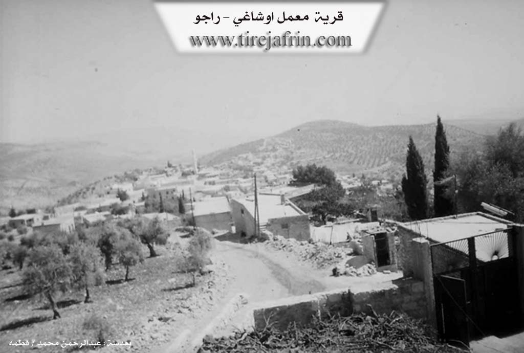
It is one of the large villages in the district of Reco. It is situated on a mountainous plateau and is the village of Ehmed Xelîl Agha from the first half of the twentieth century.
It is stated in the book عفرين .... نهرها وروابيها الخضراء Efrîn... Her River and Her Green Hills: Me'mel Uşaxî is a village in Çiyayê Kurmênc following the township of Reco, region of Efrîn, governorate of Heleb. It is a large village located on the western slope of the mentioned mountain, situated atop the summit of a limestone height (Çiyayê Skênda). It is 9 km away from the town of Reco in the southwestern direction. Two watercourses border it to the north and south, descending toward the east. Its soil is clay like.
It is bordered to the north by the village of Umera; to the south by a mountain range, a deep valley, and the village of Xelîl Kolko; to the west by a mountain range, a rugged slope, Deşta Amqê (Amik Plain), the border of Turkey directly, and the abandoned village of Kumît; and to the east by several slopes, a mountain range, and the villages of Gurkan Jêrîn and Sariya.
The number of its houses reaches approximately 300 houses, and its age is approximately 500 years according to the account of one of the elderly residents of the village. Its old houses are of stone and mud with wooden ceilings, while the modern ones are cement and have spread on the outskirts to the west and east. An electricity network is available, as well as drinking water from an artesian well belonging to the state. It contains primary and preparatory schools, an old mosque, and a telephone center. A municipality was recently established there.
The residents work in rain fed agriculture (olives, legumes, grains, vines) on an area of 488 hectares on the mountain slopes surrounding it, and in the plain of Kabire and Qûde Daş, alongside raising sheep and goats. It connects with the township and the region by an asphalt road. This village is among the large and old villages in the region. Among its most key families are: (Ehmed Xelîl, who are the owners of the village).
Village Mukhtar: Mistefa Cefer
Sources of Information:
- Book: جبل الكرد (عفرين) دراسة جغرافية Çiyayê Kurmênc (Efrîn): A Geographical Study by د. محمد عبدو علي Dr. Mihemed Ebdo Elî.
- Book: عفرين .... نهرها وروابيها الخضراء Efrîn... Her River and Her Green Hills by عبدالرحمن محمد Ebdulrehman Mihemed from the village of Qetme.
- Studies of Navenda Tirej Soft / Ebdulrehman Hacî Osman.
- Some residents of the villages.
Preparation and Execution: Manager of the site Tirej Efrîn: Ebdulrehman Hacî Osman 20/12/2013
II. Summary of Me'mala from Ax û Welat
Source: https://www.youtube.com/watch?v=AHx_io4SlBc
The village of Ma'mela, located in the Efrîn region of northwestern Syria, holds a reputation as one of the oldest settlements in the area. According to local oral history recounted by the elder Apê Biş, the village foundation dates back approximately one thousand years. The name Ma'mela is said to originate from the first settler, Ma'm. The historical narrative describes how early residents, including figures named Hemze and Hebîb, gathered their homes close together to create a defensible cluster against bandits and thieves.
The social structure of Ma'mela is defined by the Şêxo tribe. While the village is home to numerous distinct families, such as Mala Simo, Mala Cafer, Mala Îbiş, and Mala Heşoşo, the Şêxo tribal identity serves as a unifying umbrella. A significant historical landmark within the village is the Odeya Xelîl Ehmed Axa, a guest house and tribal court constructed around 1318 Hijri (approximately late 19th or early 20th century). This room served as the judicial and social center for the entire Şêxo tribe, extending its influence to surrounding areas like Meydanê and Kûsa. The room was architecturally designed with a high ceiling to compel those entering and sitting to maintain a posture of respect; sitting with legs crossed was strictly forbidden in the presence of elders.
Ma'mela is particularly renowned for its deep historical connection to olive cultivation. Residents claim it was the first location in the region to host olive presses (ma'ser). Historically, the village contained five active presses owned by prominent families such as Mala Şelfû, Mala Mihê Silo, and Mala Cemîl. Farmers from neighboring areas like Deşta Çaqala, Deşta Mistiko, and Erendê would travel to Ma'mela to process their harvest. The surrounding olive groves reportedly contain trees that are between two and three hundred years old.
The spiritual life of the village centers around a sacred site known as Ziyareta Îskender, also referred to as Ziyareta Meyremê. The site is named after a figure named Îskender, who is said to have died there while passing through from Beloy. The alternate name, Meyremê, stems from a local story involving a woman named Litfî whose daughter, Merem, was cured of illness after sleeping at the shrine. Today, the village maintains its communal spirit through modern institutions, including a clinic, a Heyva Sor center, and a weekly Sunday market established in 2014 to serve the local women and families who found it difficult to travel to the city of Efrîn.
II. Summary of Me'mala from Multi Channel
The village of Me'mela is located in the Raco district of the Efrîn region. According to local elders, the settlement was established between 500 and 700 years ago. Its name derives from a man named Me'mo, who was among the very first to settle there. Originally, the inhabitants lived in locations called Derwê Me'mela and Emero before relocating to the current village site. An elder recounts a specific story about a man named Hesen from the Birîmê family who had a disagreement with his brother. Consequently, Hesen left and settled in an upper area known as Senîckulan. Eventually, others followed his path and populated the present day location of Me'mela.
The village was initially populated by early families such as Birîmê and Me'mo. Over time, other families including Ewlê, Elî Bedo, Ca'fer, Simo, Heşaşo, Dîk, and Zîbar established themselves in the area. Local history notes that Simo later moved away to live in Xelîlalka, while Ca'fer and Elî Bedo remained in Me'mela.
There are no specific shrines mentioned by the residents, but elders recall a historical stone structure in the village known as Firneh, which was traditionally used as a prison in older times. Water scarcity has always been a defining challenge for the settlement. Because the village is situated in a dry mountainous area with no natural springs, early residents had to dig deep cisterns by hand using pickaxes just to collect rainwater. Today, water is brought in from Meydankê or purchased by the tank. Due to these harsh agricultural conditions, men historically traveled to cities like Beyrût, Heleb, and Şam for work.
Me'mela is highly renowned for its extensive olive groves. In the past, residents cultivated wheat, barley, lentils, and vineyards, but the lack of water caused a complete shift to olive farming. Despite the tough environment, the village boasts a vibrant cultural life. A shepherd named Husên from the Dîk family preserves the ancient Kurdish musical tradition of playing the nay, an instrument traditionally crafted from apricot wood, and is passing the skill to his grandson in Cindirês. The village also places a strong emphasis on education, producing doctors and engineers who have traveled to places like Almanya to study and work. Furthermore, a local teacher named Mihemed Fariz established a traditional dance troupe named Buhar, which evolved from earlier groups called Rojava and Mabeta, ensuring that the youth keep their folklore alive. A local teacher and poet named Mehdîdîn also writes verses celebrating the beauty of the region and its famous olives.
Transcriptions and Subtitles
| Source | Video | Subtitles | Transcript |
|---|---|---|---|
| Ax û Welat 1 | Watch Video | Download SRT | View Transcript |
| Multi Channel 1 | Watch Video | Download SRT | View Transcript |
Foundation/Origin Information of Me'mala
It is the village of Ahmed Khalil Agha from the first half of the twentieth century. Among its most important families are Ahmed Khalil, who are the village owners.
Source: TirejAfrin Site
Possible Village Name Meaning of Me'mala
A compound name of two Kurdish words: "Me'am" from Mahmoud, and "Il" family or group, written Me'im+êla, then became Me'mila. The Ottoman writing "Oshaghi" means "children," so the full name means children or group of Mahmoud.
Source: TirejAfrin Site
V. Links
- Tirej Afrin:
https://www.tirejafrin.com/site/kura%20afrin%20%20%20Reco%20-memala%20ushxe.htm - Ax û Welat:
https://www.youtube.com/watch?v=IVut3Xu4bgE - Link:
https://www.youtube.com/watch?v=AHx_io4SlBc - Jawlat:
https://www.youtube.com/watch?v=HyaUOZGwAPk - Link:
https://www.youtube.com/watch?v=G9bQzvXzpjw - Video:
https://www.youtube.com/watch?v=ViYUyyxyBUA - Link:
https://www.youtube.com/watch?v=X_lvNWl4hk4 - Multi Channel:
https://youtu.be/BttssVbKDJY?si=9i6bbFr_PmVYd7oW