General Information
Nahiya (Subdistrict)
Nubl
Also Known As
Meyasê, مياسة
Tribes
Benî Seîd, Benî Talib, Benî Zubeîd
Families, Clans, etc.
Mala Ferec, Mala Miko, Mala Xelef, Mala Xidiro

Photos
Basic Information about Meyasê
Source: Ax û Welat
Etymology: Named after Meyas, an Arab woman who originally owned the land where the village was founded
Foundation Date/Period: Approximately 300 to 400 years ago
Hills: Çiyayê Lêlûn, Cebel Ehlam
Other Landmarks: Soxanekê
Summaries
I. Summary from TirejAfrin Site (English) of Meyasê
Source: https://www.tirejafrin.com/site/kura%20afrin%20markaz-%20Meyase.htm
Meyas, Meyase / 490m - 40km /:
It is stated in the book جبل الكرد (عفرين) دراسة جغرافية Çiyayê Kurmênc (Efrîn): A Geographical Study by د. محمد عبدو علي Dr. Mihemed Ebdo Elî:
The meaning of the name in Kurdish is "small forest, natural wooded patch" (meyas) according to the Mukriyanî dictionary. The Kurds of Çiyayê Lêlûn use the name in the feminine form as a proper noun.
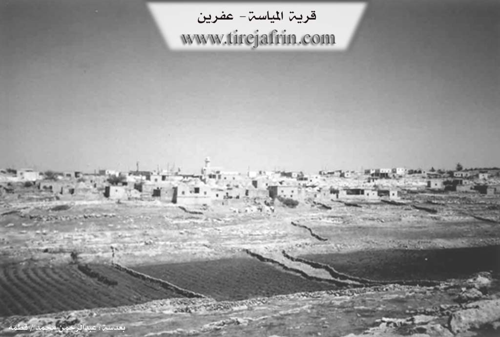
It is a small village among the villages of Çiyayê Şêrwan. It was attached to the Nibul sub-district in 1975. It contains ancient archaeological evidence from the Greek eras.
It is stated in the book عفرين .... نهرها وروابيها الخضراء Efrîn... Her River and Her Green Hills by the writer عبدالرحمن محمد Ebdulrehman Mihemed from the village of Qetme / Kirsanê:
It is a village in Çiyayê Lêlûn, administratively following the sub-district of the central villages of the Efrîn region, Heleb governorate. It is a small village located on a mountainous height in the eastern Çiyayê Lêlûn chain.
It is bordered to the north by a rugged mountain chain, some forestry trees, the village of Soxanê, and Xirbe Qunêtra. To the south, it is bordered by a mountain chain, two rugged rocky watercourses, the town of Nibul, and Burc Elqas. To the west, there is a slope and a watercourse at the bottom, a rugged mountain chain, and the archaeological village of Beradê. To the east, it is bordered by a rugged mountain chain, a watercourse, and the village of Zernîta.
The number of its houses is approximately 50 houses. The age of the village is approximately 80 years, according to the account of the residents living in the village since 1924, who came from the village of Serrîn in the Kobanê (Ayn al-Arab) region.
The old dwellings of the village are made of domes, and the modern ones are of stone and reinforced concrete. An electricity network is available. The road to the village is paved up to the center of the village; it connects to the town of Nibul. There is a primary school on the northeastern side of the village.
Its inhabitants work mainly in raising sheep and cows. They drink from pools and cisterns that collect rainwater. There are some olive trees on the southern and northern sides. Currently, the village has administratively belonged to the Nibul sub-district in the Ezaz region since 1980.
Sources:
- Book: جبل الكرد (عفرين) دراسة جغرافية Çiyayê Kurmênc (Efrîn): A Geographical Study by د. محمد عبدو علي Dr. Mihemed Ebdo Elî.
- Book: عفرين .... نهرها وروابيها الخضراء Efrîn... Her River and Her Green Hills by عبدالرحمن محمد Ebdulrehman Mihemed from the village of Qetme.
- Studies of Navenda Tirej Soft / Ebdulrehman Hacî Osman.
Preparation and Execution:
- Manager of the Tirej Efrîn website: Ebdulrehman Hacî Osman
- 20/12/2013
II. Summary of Meyasê from Ax û Welat
Source: https://www.youtube.com/watch?v=0kfJ5S0VtfU
The village of Meyasê is located in the Şêrawa region of Efrîn, situated on the rocky terrain of Çiyayê Lêlûn (also known as Çiyayê Kurmênc). Unlike the plains of western Kurdistan, this area is defined by its stone landscape, where traditional homes and structures are built directly from the local rock. The village derives its name from Meyas, an Arab woman who was the original landowner when the first settlers arrived.
According to village elder Mehemed, the settlement was founded approximately 300 to 400 years ago by four brothers: Ferec (the eldest), Hemed (or Mehemed), Miko, and Casim. These brothers migrated from Yemen and identified with the Benî Seîd tribe, with lineage connections to Benî Zubeîd and Benî Talib. While they were ethnically Arab, the community has undergone a complete cultural and linguistic assimilation over centuries, now speaking Kurmanji and identifying with Kurdish customs. Before settling in Meyasê, the group passed through Kurzêlê, associated with Mala Botarî and Mala Şêxî. One of the brothers, known as Melîkê Kerrî, separated from the group and settled in Zernêîtê, while the descendants of the remaining brothers established the primary families of the village, such as Mala Ferec, Mala Xelef, and Mala Miko.
The architectural history of Meyasê is distinct, featuring domed structures known as "Qub" or "Qab," which were used for living, sleeping, and stabling animals. These stone buildings are characteristic of Şêrawa and Çiyayê Lêlûn. Additionally, the village contains underground storage cellars ("bin erd") dating back to the Ottoman era. These were originally excavated to hide wheat, barley, and other provisions from Ottoman tax collectors who would confiscate the harvest.
Culturally, the village has a rich tradition of oral history and self-sufficiency. Residents like Hecî recall a time of deep engagement with Kurdish music, mentioning local singers and musicians such as Elî Henîn, Hesenê Gerûd, Remezan, and Elî Hec Ebdû, who would perform epics like Derwêşê Evdî in village gatherings. Traditional medicine was also prominent; the village healer Xedra describes treatments for ailments using cauterization and herbal remedies. Midwifery was historically handled by local women like Eşê and Zelûxê (also known as Pîra Zel) from the neighboring village of Oqîbê. For spiritual healing, specifically for mental distress ("mêrestan"), villagers historically visited a site called Soxanekê to perform smoke rituals.
Economically, the village traditionally relied on sheep and goat herding and the cultivation of grain crops like wheat, barley, and lentils. Due to the scarcity of wood in the rocky Şêrawa hills, women in the village, such as Zwara, still practice the preparation of "tepik" (dung cakes) for fuel. While trees were historically scarce, the village has recently planted thousands of olive trees. A prominent geographical feature nearby is Cebel Ehlam, a viewpoint on the mountain range, though locals prefer the historical name Çiyayê Lêlûn.
Transcriptions and Subtitles
| Source | Video | Subtitles | Transcript |
|---|---|---|---|
| Ax û Welat 1 | Watch Video | Not Available | View Transcript |
Foundation/Origin Information of Meyasê
Founded by four brothers—Ferec, Hemed, Mela, and Casim—who migrated from the village of Kurzêlê. Originally from the Arab Botari clan a branch of the Al-Aoun/Bani Sa'id tribe, the villagers have since assimilated into the local culture.
Source: Ax û Walat Transcript
Possible Village Name Meaning of Meyasê
The village itself is named after a woman, Meyasê.
Source: Ax û Walat Transcript