General Information
Nahiya (Subdistrict)
Reco
Also Known As
Meydan Akbas, Meydan Ekbes, Meydan Ekbez, Meydan Ekbezê, Meydan Ekbis, Stesûn, ستيسون, ميدان اكبس, دوكان
Families, Clans, etc.
Bîrincî, Cuma, Depe, Dûdê, Ebû Şêro, Gewanda, Izet Axa, Kûsa, Mehmûd Axa, Penêreka, Weliklê, Şêx Mihemed

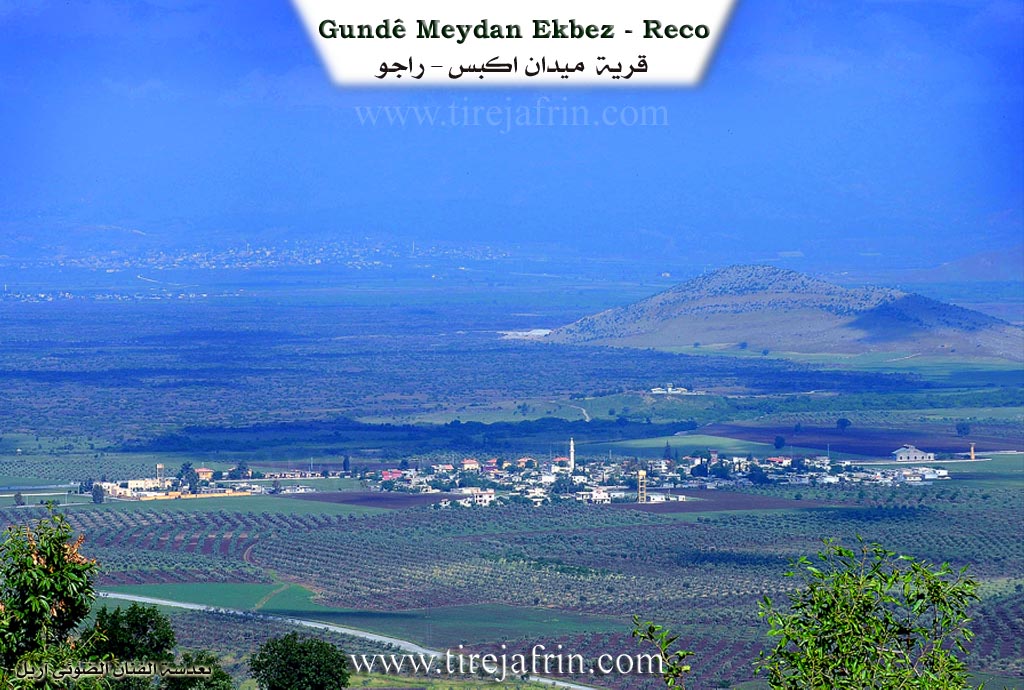
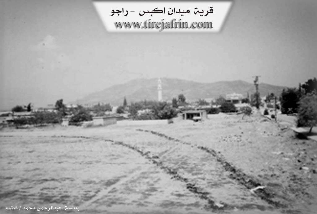
Photos

Basic Information about Meydan Ekbez
Source: Ax û Welat
Foundation Date/Period: 1911
Hills: Çoyê Hewarê, Çoyê Xweştya, Çoyê Lêlûn, Eftar
Ruins: Wêranşahr, Kele
Other Landmarks: Îstasyona Meydan Ekbez, Cisr el-Dewwar, Sînî Dewwar, Menhel
Summaries
I. Summary from TirejAfrin Site (English) of Meydan Ekbez
Source: https://www.tirejafrin.com/site/kura%20afrin%20%20%20Reco%20-%20Meydan%20Ekbe.htm
According to the book جبل الكرد (عفرين) دراسة جغرافية Çiyayê Kurmênc (Efrîn): A Geographical Study: Meydan Ekbez / 1216 inhabitants, 502 hectares, 22 km from center, 372 m altitude /:
Meydan: means the square or arena (meydan) in Kurdish, and Ekbez is the name of a Kurdish village on the Turkish side of the border. Kurds also call it Stesn meaning "The Station," in reference to the important train station located there.
The founding of this village dates back to the date of the construction of the train station in the early second decade of the twentieth century. Its first inhabitants were Armenians who were sheltering with French forces from the persecution of Turkish soldiers. This large village is located in the middle of a wide plain, crossed by Çemê Reş (Black River), and covered by fertile volcanic soil. Its location is in the extreme northwestern corner of the Turkish and Syrian border.
According to the book عفرين .... نهرها وروابيها الخضراء Efrîn... Her River and Her Green Hills: Meydan Ekbez is a village in Çiyayê Kurmênc that follows the township of Reco, region of Efrîn, governorate of Heleb. It is a large town located in the middle of a wide rift valley plain, traversed by Çemê Reş (Black River) heading towards the south, and covered by fertile volcanic soil. It is the meeting point of the Syrian border with the Turkish border, and the Xeta Trêna Heleb-Tirkiye (Aleppo-Turkey railway line) crosses it. It is 22 km away from the town of Reco towards the north.
It is bordered to the north at a distance of 50 m by the Turkish border and Çemê Reş (Black River); to the south by a wide fertile plain and the village of Qere Baba; to the east by a fertile plain and the mountainous Meydan villages (Bender, Kûsan, Şêx Mihemed, Semalik Reco); and to the west at a distance of meters by the train station, Çemê Reş (Black River), and the Turkish border directly.
The number of its houses reaches about 250 houses and its age is about 450 years. Its old residences are stone made of basalt with wooden roofs, while the modern ones are cement and have extended towards the south and east. It has an electricity network and a drinking water network from an artesian well belonging to the state. It contains a telephone center, post office, primary and middle schools, a modern mosque, and a large old train station built in 1911 AD (built by the Germans). The Stesna Meydan Ekbez (Meydan Ekbez station) is considered one of the largest train stations after the central station in Heleb due to its proximity to the border Syria Turkey, and its construction is very beautiful in the German architectural style.
There is also a customs secretariat, General Security, and a police station. It has several commercial and service shops. The residents work in rainfed agriculture (grains, legumes) on an area amounting to 502 hectares, and in irrigated agriculture via pumping from Çemê Reş (Black River) (sugar beet, cotton, summer vegetables, fruit trees) on a small area. Currently, they have started planting olive trees. The locals also work in raising cows, sheep, and goats, while others work in trade, various professions, and services due to it being a border point. A municipality was recently established there, to which neighboring villages were annexed. It connects to the township center via a winding asphalt road. It is the last village on the northwestern side in the region of Efrîn and Syria, and it is also the longest point of border contact with the Turkish lands along the (Syria Turkey) border.
It is mentioned that the artist and maestro Şêro Menan is one of the sons of this village. Among the holders of higher degrees in the village is Mihemed Xelîl Ismaîl (PhD in Geological Sciences / France).
Village Mukhtar: Faîq Hac Ehmed
Sources of Information:
- Book: جبل الكرد (عفرين) دراسة جغرافية Çiyayê Kurmênc (Efrîn): A Geographical Study by د. محمد عبدو علي Dr. Mihemed Ebdo Elî.
- Book: عفرين .... نهرها وروابيها الخضراء Efrîn... Her River and Her Green Hills by عبدالرحمن محمد Ebdulrehman Mihemed from the village of Qetme.
- Studies of Navenda Tirej Soft / Ebdulrehman Hacî Osman.
- Some residents of the villages.
Preparation and Execution: Manager of the website Tirej Efrîn: Ebdulrehman Hacî Osman 20/12/2013
II. Summary of Meydan Ekbez from Ax û Welat
Source: https://www.youtube.com/watch?v=pMGg79eSuwY
The history of Meydan Ekbez, located in the Afrin region (referred to as Çiyayê Kurmênc), is inextricably linked to the construction of the Baghdad Railway. According to local accounts, the village did not exist prior to the 20th century. The site was originally a field or plain ("meydan") located near the older village of Ekbez, which now lies across the border in Bakurê Kurdistan. The modern settlement began in 1911 when Aleman (Germans) constructed the Îstasyona Meydan Ekbez (Meydan Ekbez Station). This station became a vital hub connecting Istanbul to Heleb (Aleppo) and Bexda (Baghdad), necessitating a complex infrastructure including a turntable bridge known locally as Cisr el-Dewwar or Sînî Dewwar, and a water filling facility called Menhel.
The demographic foundation of the village occurred in 1915. Fleeing the genocide and war, Ermenî (Armenians) settled in the area and constructed the first houses. The host notes that while the land historically belonged to Kurds, the village itself was built by these Ermenî refugees. Prior to this, the Ottoman government had attempted to settle Çerkez (Circassians) on this land, but they eventually abandoned it due to the climate and difficulties with the terrain. Following the end of the Ottoman era and the arrival of the Fransa French mandate forces around 1918–1920, the French authorities consolidated two smaller "fakir" hamlets into the main village. Over time, the Ermenî population departed for cities like Beyrût, Heleb, and Şam, or moved to Rûsya.
As the Ermenî population left, Kurdish families from the surrounding Meydan area and villages now located in Bakurê Kurdistan moved into the empty homes. The village elder, Hecî Bekir (95 years old), explains that the current residents are descendants of these migrants. He identifies specific families and lineages such as the Bîrincî, Şêx Mihemed, Kûsa, and Penêreka, as well as groups who originated from villages like Weliklê, Dûdê, and Gazê. Today, the village consists of approximately 450 households, all of whom are Kurds.
Geographically, Meydan Ekbez is a border town. It sits adjacent to the Turkish border, with the villages of Ekbez and Heyderko visible just a kilometer or two away on the other side. The landscape is defined by nearby peaks such as Çoyê Hewarê, Çoyê Xweştya, and Çoyê Lêlûn. The area also contains historical ruins known as Wêranşahr, where a Kele (castle) and ancient city walls reportedly once stood. The railway station, once a bustling center of trade and travel hosting the famous Şerq el-Serî (Orient Express), has ceased operations, and the tracks and machinery like the Cisr el-Dewwar now stand as silent monuments to the village's industrial origins. The village is also home to the artist Ekaş Dilar.
II. Summary of Meydan Ekbez from Multi Channel
The documentary provides an in depth historical and cultural overview of Meydan Ekbes, a village situated on the border with Tirkiye in the Raco district of the Efrîn region. The name of the village originates from a local grass known as Ekbes that grew abundantly on the flatland, or Meydan. The village is also commonly referred to as Îstasyon or Mehete because of its historic train station.
According to the local mukhtar, Meydan Ekbes was founded approximately 110 to 119 years ago, specifically around 1913, coinciding with the construction of the railway by the Alman and Fransî authorities. Before the railway, the area had no permanent settlement, consisting only of temporary barracks and a harsh, hot environment. The village is unique in that it has no original indigenous inhabitants. People migrated to the newly built station from surrounding villages such as Kosa and Xweştan in search of work. Around 1920, Ermenî refugees arrived and settled temporarily before dispersing to cities like Heleb, Şam, Beyrût, and beyond, though their graveyard remains in the village today.
Historically, the village land was owned by local Aghas. The foundational families who settled the area include the family of Mehmûd Axa, the family of Cuma, and the family of Izet Axa. Over time, the village grew to about 370 households. The village has a strong reputation for education, producing many professionals such as an agricultural engineer from the Ebû Şêro family, the late veterinarian Ehmed Bêrem, and lawyers. It is also the home of the renowned Kurd singer Ekkaş Dildar, whose musical legacy is carried on by his grandson Dildar.
Meydan Ekbes became famous as a major transit and trade hub. Its railway connected Sûriye with Stenbol and the broader network, facilitating both passenger travel and commercial trade. The station area still features original 1913 buildings of Alman and Fransî architecture. During the Îngilîz and Fransî mandates, it operated as a formal border crossing with customs and passport control. Travelers of Turk and Îranî origin frequently passed through. However, following the crisis in Sûriye, train operations ceased entirely.
Today, the local economy relies heavily on agriculture on the vast Deşta Hemqê or Deşta Meydan Ekbes plain. Farmers cultivate olive varieties like Zeytî, Xelxal, and Sûrranî. Historically, water was more abundant, and locals would grind their wheat at an old water mill named Aşê Gûr or travel to Bilbilê. Despite modern hardships from droughts and earthquakes, the villagers maintain their cultural traditions, with local women from families originating in nearby places like Turkalî, Xosê, and Qurbanê still preparing heritage foods like genaşoş and baking traditional flatbreads.
Transcriptions and Subtitles
| Source | Video | Subtitles | Transcript |
|---|---|---|---|
| Ax û Welat 1 | Watch Video | Download SRT | View Transcript |
| Multi Channel 1 | Watch Video | Download SRT | View Transcript |
Foundation/Origin Information of Meydan Ekbez
The establishment of this village dates back to the construction of the train station in the early second decade of the twentieth century. Its first inhabitants were Armenians who served the French forces during the persecution of Turkish soldiers.
Source: TirejAfrin Site
Owes its existence to the Berlin-Baghdad railway. The Ottoman government had settled Circassians and Armenians in the area. The village itself formed around the station, with its population growing significantly after 1915 when Armenian refugees, fleeing conflict with the Turks, settled alongside the local Kurdish population.
Source: Ax û Walat Transcript
Its founding directly linked to the construction of a train station in 1911 by the Germans. The first inhabitants were Armenian refugees who settled there to escape persecution from the Ottomans, living under the protection of French forces. Subsequently, the village grew by attracting residents from neighboring villages, including Meduno and Kişand.
Source: Afrin 366 Transcript
Possible Village Name Meaning of Meydan Ekbez
Meydan means the square in Kurdish, and "Akbaz" is the name of a Kurdish village on the Turkish side of the border. Kurds also call it Stesûn "the station".
Source: TirejAfrin Site
The area was an open field known as Wêranşehr.
Source: Ax û Walat Transcript
Known locally by the Kurdish name "Stesûn," meaning "station."
Source: Afrin 366 Transcript
V. Links
- Tirej Afrin:
https://www.tirejafrin.com/site/kura%20afrin%20%20%20Reco%20-%20Meydan%20Ekbe.htm - Link:
https://www.youtube.com/watch?v=pMGg79eSuwY - Link:
https://www.facebook.com/Kutdistan2 - Link:
https://www.esyria.sy/2014/09/%D9%85%D9%8A%D8%AF%D8%A7%D9%86-%D8%A3%D9%83%D8%A8%D8%B3-%D8%A7%D8%B3%D9%85-%D8%A7%D8%B1%D8%AA%D8%A8%D8%B7-%D8%A8%D9%82%D8%B7%D8%A7%D8%B1-%D8%A7%D9%84%D8%B4%D8%B1%D9%82 - Multi Channel:
https://youtu.be/0I2aNR24z28?si=F4E0deOPEc6Sdfdl