General Information
Nahiya (Subdistrict)
Mabeta
Also Known As
Ashour, Masto Ashour, Mist'ešûra, عاشور, مستو عاشور
Tribes
Xastiyan

Photos
Basic Information about Mist'eşûra
Source: Tirej Afrin
Etymology: A local Kurdish proper name formed by merging the two names Mistefa and 'Aşûr. The Arabized version took the second half of the name.
Foundation Date/Period: Approximately 250 years ago
Other Landmarks: Sîlî, Cercim
Summaries
I. Summary from TirejAfrin Site (English) of Mist'eşûra
Source: https://www.tirejafrin.com/site/kura%20afrin%20%20%20mebetli%20-%20mist%20ashora.htm
Mist'eşra / Mistû 'Aşûr
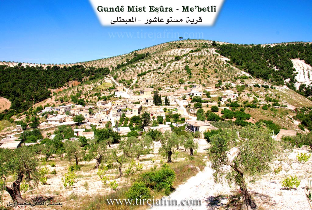
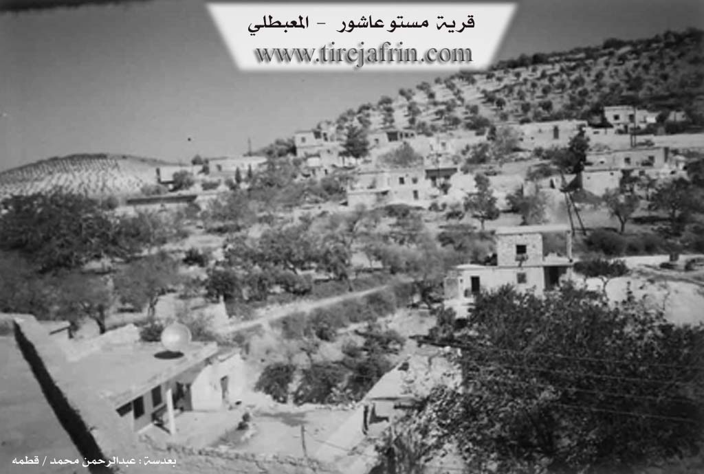
According to the book جبل الكرد (عفرين) دراسة جغرافية Çiyayê Kurmênc (Efrîn): A Geographical Study by د. محمد عبدو علي Dr. Mihemed Ebdo Elî, the village is named Mist'eşra, Mistû 'Aşûr, or 'Aşûr. There are 508 inhabitants, and it is located at an altitude of 620m, approximately 14km away. The name is a local Kurdish proper name formed by merging the names Mistefa and 'Aşûr, while the Arabized version adopted the second half of the name. It is a small village of the Xastiyan tribe, located on both sides of a valley that cuts through it from the northwest toward the southeast. Oak and pine trees, as well as olive groves, are spread around it.
According to the book عفرين .... نهرها وروابيها الخضراء Efrîn... Her River and Her Green Hills by the writer عبدالرحمن محمد Ebdulrehman Mihemed from the village of Qetme, Mistû 'Aşûr is a village in Çiyayê Kurmênc, administratively belonging to the Mabeta district of the Efrîn region in the Aleppo governorate. It is a small village situated in the middle section of the mentioned mountain, on the western slope of a marly limestone plateau that overlooks the south and east. It overlooks the valley of Sîlî, which heads south, passing through the center of the village toward the valley of Cercim.
The village is bordered to the north by a high mountain range planted with olive trees, several watercourses, and the village of Elî Caro. To the south, it is bordered by a slope, the valley of Sîlî (which divides the village into two sections: western and eastern), the valley of Cercim, and the village of Rotanlî located on a high mountain peak. To the west, there is a high mountain range planted with forest trees and olives, along with the villages of Maxarcik and Turmişkanlî. To the east, there is a high mountain ridge, a very deep valley, and the village of Şêrkanlî.
The number of houses reaches approximately 55, and the village is about 250 years old. Its houses are made of stone and mud with flat wooden roofs, though modern cement dwellings have begun to spread around them, replacing the old houses. An electricity network and a primary school are available in the village. The village gets its drinking water from cisterns that collect rainwater in winter. The residents work in rain-fed agriculture such as olives, grains, and apricots, alongside raising sheep and goats. It is located about 17km southwest of the town of Mabeta, and it is connected to the district center by a paved road reaching the center of the village.
Village Mokhtar: Remzî Heqî
Sources:
- Book: جبل الكرد (عفرين) دراسة جغرافية Çiyayê Kurmênc (Efrîn): A Geographical Study by د. محمد عبدو علي Dr. Mihemed Ebdo Elî.
- Book: عفرين .... نهرها وروابيها الخضراء Efrîn... Her River and Her Green Hills by عبدالرحمن محمد Ebdulrehman Mihemed from the village of Qetme.
Preparation and Execution:
- Manager of Tirej Efrîn site: Ebdulrehman Hacî Osman
- 20/12/2013
II. Summary of Mist'eşûra from Afrin 366
Source: https://www.youtube.com/watch?v=F25V9dqaZ3k
The documentary focuses on the village of Mist Eşûra, which is located within the administrative jurisdiction of the Mabatoyê region. The village is inhabited by approximately sixty to seventy households. Geographically, Mist Eşûra is described as sitting within a "kort" (a hollow or depression), surrounded by a natural landscape distinguished by the presence of Merx trees.
Regarding the village's infrastructure, the transcript notes the existence of a school and a mosque. However, the roads leading into and through the settlement are highlighted as being particularly rough and difficult to navigate. During the visit, the host enters the home of a resident referred to as Apô Azad, exchanging greetings with him and other locals like Meyo Cemal.
A substantial portion of the record documents a chance encounter with a mobile vaccination team operating in the area, specifically mentioning their work near Sikêniyê as well. The medical personnel discuss their efforts to immunize the local population against "şelel el atfal" (polio) and "surka" (measles). They address the difficulties of combating false rumors regarding vaccine safety and explain their process of issuing "bitaqa spî" (white cards) to track the health records of the children.
Throughout the footage, a song dedicated to the Efrîn region provides a cultural backdrop, referencing significant regional landmarks such as Deşta Cûmê, Çiyayê Hawar, and Kel a Horî, as well as symbolic names like Eynûne and Zeytûne. These references situate Mist Eşûra within the broader emotional and geographical context of the region, even though those specific landmarks are not located within the village itself.
Transcriptions and Subtitles
| Source | Video | Subtitles | Transcript |
|---|---|---|---|
| Afrin 366 1 | Watch Video | Download SRT | View Transcript |
Possible Village Name Meaning of Mist'eşûra
A local Kurdish proper name formed by combining the names Mustafa and Ashour. Arab speakers took the second half of the name, Ashour.
Source: TirejAfrin Site