General Information
Nahiya (Subdistrict)
Reco
Also Known As
Al-Sawda, Qere Baba, Qerebaba, السوده, قره بابا, قربابا
Families, Clans, etc.
Beker Agha, Birokê Heyder, Heyderî Bêkir, Mala Bekir Axa, Mala Bextê, Mala Elî Guleme, Mala Elî Gulemê, Mala Elî Hemed, Mala Elî Şeref, Mala Evdikê, Mala Gîsim, Mala Hecî Xelîl, Mala Heyderê Bekir, Mala Memîtkû, Mala Mixtê, Mala Piling, Mala Xalê Mistefa, Mala Şêref, Mala Şêxû, Malê Cîsim, Malê Elî Şeref, Malê Evdikin, Malê Memîtkin, Malê Piling, Maxtê, Molî Şêxû

Photos
Basic Information about Qere Baba
Source: Ax û Welat
Etymology: Named after Ziyareta Qerababa (Shrine of Qerababa), meaning "Black Father" in Turkish/Ottoman
Foundation Date/Period: Over 500 years ago
Caves: Şikefta Qopî
Number of Caves: 1
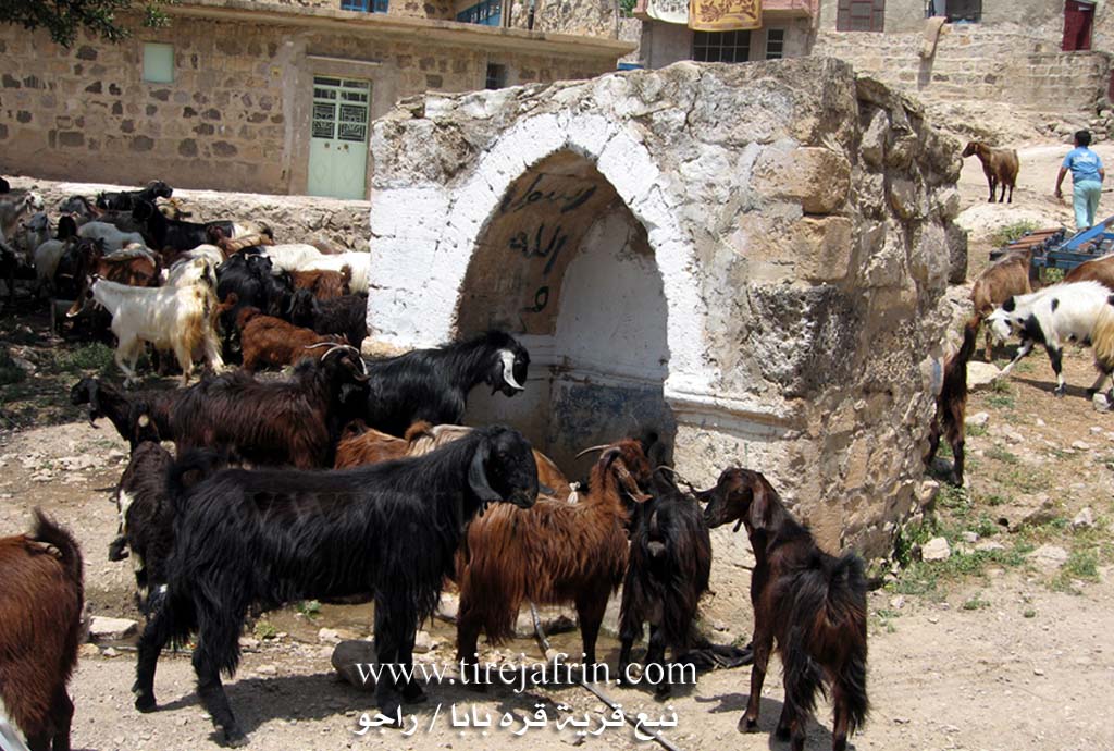
Springs: Kaniya Hecî Xelîl
Hills: Serî Leçê
Shrines: Ziyareta Qerababa, Tirba Qerababa
Trees: Dara Polîtê, Dara Tibiqê
Other Landmarks: Ava Reş, Pira Heşer ke
Source: Afrin 366
Shrines: Ziyareta Qarebaba
Wells: Bîrê mefreqê gund
Other Landmarks: Mefreqê Qarebaba, Mekbaz
Summaries
I. Summary from TirejAfrin Site (English) of Qere Baba
Source: https://www.tirejafrin.com/site/kura%20afrin%20%20%20Reco%20-%20Qere%20Baba.htm
It is stated in the book جبل الكرد (عفرين) دراسة جغرافية Çiyayê Kurmênc (Efrîn): A Geographical Study: Qerebaba, Al-Sawda /942 people, 430 hectares, 11km, 480m/:
Qerebaba: A name of Turkish origin meaning "The Black Father" (Qere + Baba). The Arabized name is an incomplete translation of the Turkish designation.
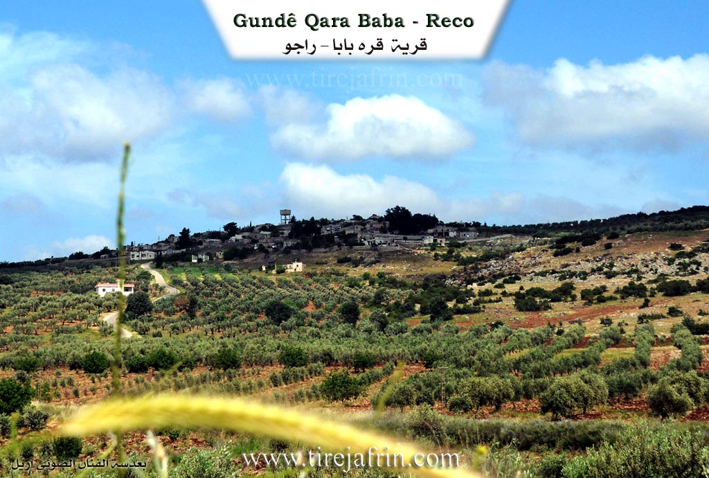
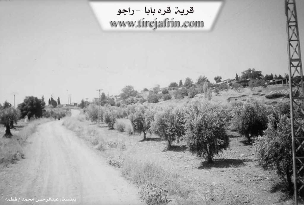
This medium sized village is located on the summit of an elevation that slopes down towards the course of the Çemê Reş to the west. It is 1km away from the Turkish border.
It is stated in the book عفرين .... نهرها وروابيها الخضراء Efrîn... Her River and Her Green Hills: Qerebaba is a village in Çiyayê Kurmênc following the Reco district, Efrîn region, Heleb governorate. It is a small village located on an elevation of the western slope of Çiyayê Kurmênc near the borders of Turkey on the northwestern side of the Efrîn region. It sits on a fertile mountain slope and is surrounded by olive trees.
It is bordered to the north by a slope planted with forest trees and olives and the town of Meydan Ekbez. To the south, it is bordered by a slope, Deşta Amûqê, the course of the Çemê Reş, and the borders of Turkey directly. To the west, it is bordered by a slope, the Çemê Reş, and the borders of Turkey at a distance of 500m. To the east, it is bordered by a fertile plain, the public road (Riya Reco-Meydan Ekbez), and the villages of Ferferîkê Jêrîn and Selûk.
The number of its houses reaches approximately 40 houses, and its age is approximately 350 years according to the account of the village Mukhtar. Its dwellings are old, made of stone and mud with flat wooden roofs, and recently cement houses have spread to the east and south. An electricity network and drinking water from an artesian well are available, as well as a primary school. It connects to the public road via a paved but unasphalted dirt road.
The residents work in rain fed agriculture (olives, vines, grains) and irrigated agriculture from the Çemê Reş (summer vegetables, cotton, watermelon, sunflower, apples, walnuts, cherries...). Among its most key families is the Beker Agha family, who are the original owners of the village. Its soil is fertile and alluvial due to its proximity to the Çemê Reş.
Village Mukhtar: Mehmûd Mihemed Henan
Sources of Information:
- Book: جبل الكرد (عفرين) دراسة جغرافية Çiyayê Kurmênc (Efrîn): A Geographical Study by د. محمد عبدو علي Dr. Mihemed Ebdo Elî.
- Book: عفرين .... نهرها وروابيها الخضراء Efrîn... Her River and Her Green Hills by عبدالرحمن محمد Ebdulrehman Mihemed from the village of Qetme.
- Studies of Navenda Tirej Soft / Ebdulrehman Hacî Osman.
- Some residents of the villages.
Preparation and Execution: Manager of the website Tirej Efrîn: Ebdulrehman Hacî Osman 20/12/2013
II. Summary of Qere Baba from Ax û Welat
Source: https://www.youtube.com/watch?v=lDQnk-ICujM
The village of Qerababa, located in the Reco district of Efrîn, has a history spanning more than five centuries. According to local elder Apê Elî, the settlement was founded over 500 years ago, initially established as a small hamlet (mezre) by a stranger who settled near a spring. Over time, the abundance of water attracted others, expanding the hamlet into a full village. The village derives its name from the Ziyareta Qerababa, a shrine located at the village entrance. Residents explain that "Qerababa" is an Ottoman Turkish term meaning "Black Father." Approximately twenty years prior to the filming, the Baathist government attempted to Arabize the name to El-Sewda, but the locals persist in using the original Kurdish and Ottoman designation.
The Border and Separation
A defining aspect of Qerababa's modern history is the imposition of the border between Rojava and Bakur. In the 1920s and finalized around 1939, the border line was drawn, severing Qerababa from its neighboring villages of Çaqela and Qerefaxlo in the north. Apê Feyzî, an elder who recalls the border's establishment in 1939, describes how the division cut the villagers off from their agricultural lands and relatives on the other side. Historically, the area functioned as a single community with fluid movement for grazing and trade, particularly towards Axdapez, but the erection of wire fences and military zones permanently fragmented these social and economic ties.
Social Structure and Families
The village was originally anchored by two primary families, including Mala Elî Gulemê and Mala Mixtê (also referred to as Mala Bextê). Over time, immigrants attracted by the fertile land and strategic location for grazing settled there, including Mala Piling, Mala Gîsim, Mala Evdikê, Mala Elî Şeref, and Mala Memîtkû. The village maintains strong communal traditions; for example, the Mala Bekir Axa house served as a central gathering point during Eid, where families would bring food to share in a collective meal, reinforcing social bonds.
Sacred Sites and Landmarks
The spiritual center of the village is the Ziyareta Qerababa (also called Tirba Qerababa). It is believed to house the graves of seven martyrs (Heft Şehîd). Historically, villagers would sacrifice black animals here to pray for rain or health. Another significant landmark is the main village spring, which flows from inside a cave identified as Şikefta Qopî. This water source was historically the heart of social life, surrounded by plane trees and even a bathhouse (hemam) in the past. A local legend claims that anyone who drinks from this water will never leave the village. The village is also defined by the Ava Reş river, used for irrigating orchards, and the ancient stone bridge, Pira Heşer ke. Cultural traditions, such as the sewing of the Fistanê Kurmancî (traditional dress), remain active through residents like Nadiye.
II. Summary of Qere Baba from Ax û Welat 2
Source: https://www.youtube.com/watch?v=n1xGcIpynVI
The village of Qerebaba is located in the Raco district of the Efrîn region roughly 11 kilometers north of the town of Raco. It sits directly on the border separating Rojava from Bakur. The village was founded more than 500 years ago initially as a farm or mezre centered around a vital water source. The name Qerebaba is derived from the local shrine Ziyareta Qerebaba which residents describe as a Turkish or Ottoman name meaning Black Father. During the Ba'athist era the Syrian government Arabized the name to El Soda but the locals retained the original Kurmanji and Ottoman designation.
The history of Qerebaba is defined by the imposition of the border in the early 20th century specifically mentioned as events around 1920 and 1939. This geopolitical division severed Qerebaba from its neighboring village Çeqela also known as Söğüt on the Turkish side as well as Qerefaxla. Elders like Fêzî recall that before the wire fences and landmines were installed the villagers owned land and grazed livestock on the Girê wî and freely traveled to Axdepê. Despite the physical separation families remain kin to those across the border.
The social structure of the village is anchored by several long standing families including Mala Elî Guleme and Mala Elî Hemed also known as Maxtê who are considered the foundational lineages. Other families include Malê Piling Malê Cîsim Malê Evdikin Malê Elî Şeref and Malê Memîtkin. Community life historically revolved around the guest room of Mala Bekir Axa where families would gather during Eid to share communal meals. Another focal point of social life was the Dara Ke'nê a large oak tree where elders such as Elî Şêref Rehmetî Hanê Dalgirî and Hanê Cumi would sit and tell stories before the arrival of electricity in the mid 1980s.
Water sources are central to the identity and legends of Qerebaba. The primary spring known as Kaniya gund is located inside a cave called Şkefta Kaniya Gund. According to local lore explained by Hisên anyone who drinks from this spring will never leave the village. In the past a specific ritual involved the Mala Elî Guleme family who were responsible for placing a special stone into the water to pray for rain during droughts. The village also features the Ava Reş river and a French era bridge known as Pira Heşarge.
Religious heritage remains visible through the Ziyareta Qerebaba which was once a site containing seven tombs believed to be martyrs. Over time a mosque was constructed at the site encompassing the shrine. Today residents continue to maintain their customs including the sewing of traditional Kurmanji dresses for Newroz and March 8th celebrations ensuring the visual culture of Efrîn persists.
II. Summary of Qere Baba from Afrin 366
Source: https://www.youtube.com/watch?v=Og28okvlIu8
The village of Qarebaba is situated in a high altitude location within the Afrin region. The settlement is described by the host as a paradise and is distinguished by its elevation. A primary spiritual landmark in the village is Ziyareta Qarebaba, which is identified as a tomb ("tirba") and serves as a significant site for the locals.
The social structure of the village is centered around close knit households. A prominent elder in the community is Xalê Mistefa, whose age is estimated between eighty and ninety years old. He suggests that he was born around 1934 ("sî û çaran"). Xalê Mistefa recounts building a wall for a tenûr (bread oven) as a charitable act ("xêr") for his parents. The host visits the home of Xalê Mistefa, noting that the courtyard of the house was constructed in 1952.
Migration and diaspora are part of the village narrative. While the elders remain in Qarebaba, younger generations have moved to urban centers. Specific mention is made of family members living in Libnan (Lebanon), such as Riyad, and others who grew up in Heleb (Aleppo). The community maintains connections with these absent relatives, sending greetings to individuals such as Adnan, Mihemed, Roza, Giyo, and Wa. A local woman named Şehrûra is also featured preparing bread at the tenûr.
The village is described as not being very large, containing approximately seventy households ("hefte mal"). Key landmarks identified during the tour include the Mefreqê Qarebaba (the intersection of Qarebaba), a well located at this intersection known as Bîrê mefreqê gund, and a structure referred to as Mekbaz. The host emphasizes the beauty of the local environment, declaring that even the stones of the village are preferable to the cities of others.
Transcriptions and Subtitles
| Source | Video | Subtitles | Transcript |
|---|---|---|---|
| Afrin 366 1 | Watch Video | Download SRT | View Transcript |
| Ax û Welat 1 | Watch Video | Download SRT | View Transcript |
| Ax û Welat 2 | Watch Video | Download SRT | View Transcript |
Foundation/Origin Information of Qere Baba
The Bakr Agha Family are the original owners of the village.
Source: TirejAfrin Site
The settlement was founded by two primary families, Malbata Elî Gulemê and Malbata Mela Mextêd.
Source: Ax û Walat Transcript
Possible Village Name Meaning of Qere Baba
Originally a Turkish name meaning 'the black father'. The Arabic name, Al-Sawda, is an incomplete translation.
Source: TirejAfrin Site
Its name originates from a pre-existing shrine, 'Ziyareta Qerebaba,' which itself bears a Turkish name from the Ottoman presence.
Source: Ax û Walat Transcript
Its identity and name are derived from the shrine (Ziyareta Qerebaba) of a revered figure from the Ottoman era. The original Turkish name was officially changed to the Arabic 'Al-Sawda' by the Syrian government.
Source: Ax û Walat Transcript
V. Links
- Tirej Afrin:
https://www.tirejafrin.com/site/kura%20afrin%20%20%20Reco%20-%20Qere%20Baba.htm - Ax û Welat:
https://www.youtube.com/watch?v=lDQnk-ICujM - Video:
https://www.youtube.com/watch?v=b2krctZNu70 - Ax û Welat:
https://www.youtube.com/watch?v=n1xGcIpynVI - Afrin 366:
https://www.youtube.com/watch?v=Og28okvlIu8