General Information
Nahiya (Subdistrict)
Bilbilê
Also Known As
Qota, قوطان, قوطانلي, قوطه
Tribes
Sêmalka
Families, Clans, etc.
Dewecî, Eşteran, Henênî Cindo, Sîmoyên Hemadî, Xelîl Bese, Êmçûço, Îbiş

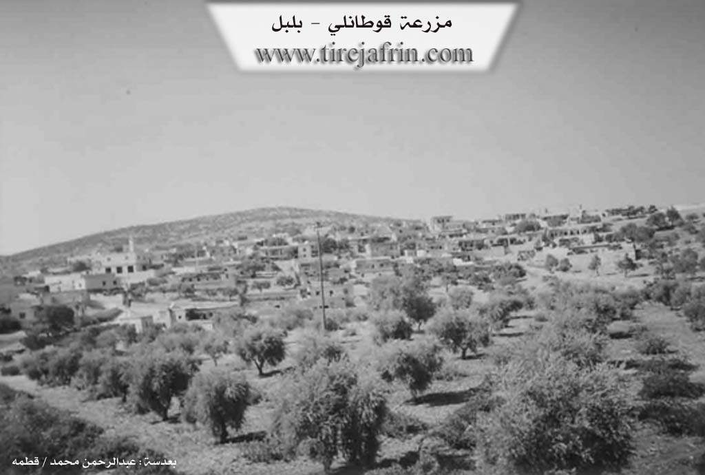
Photos
Basic Information about Qota
Source: Ax û Welat
Etymology: Named because its landscape features are shallow and not deep
Springs: Eyno Gule, Gozha Kehnikê
Hills: Çiyayê Qûta
Shrines: Keha, Zêwê Sîwar, Sedî Sînek
Ruins: Keloşkê
Trees: Dara Merxê, Kûrmê Axê
Other Landmarks: Geliyê Sor, Geliyê Zeytûnê
Summaries
I. Summary from TirejAfrin Site (English) of Qota
Villages of Bilbile District / bilbile
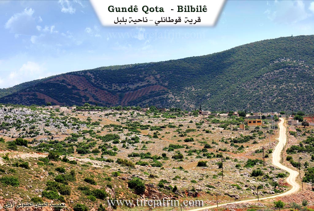
Qotānlī (قوطانلي) - Qota
===
According to the book 'جبل الكرد' 'Mountain of the Kurds' / Afrin City / Geographical Study:
Qota, Qotānlī (قوطانلي), Qotān (قوطان) /2148N - 700m/:
- Qot: in Kurdish means "naked or bare," and "se raqot" means naked or bare head. There is an archaeological ruin named Qotê or Kotê on the adjacent elevation, and it is believed that the village name is derived from it and from its "bare" location visible from afar. Also "Qot" is the name of a small Kurdish tribe.
- A medium-sized village located on a mountain plateau. It contains remains of a water mill that used to work with a mechanism for lifting water from a ground cistern to the top then pouring it on the mill's wheel, and it is unique of its kind in the Afrin City region (منطقة عفرين).
According to the book 'عفرين .... نهرها ورؤابيها الخضراء' 'Afrin City .... Its River and Green Hills':
Qotānlī (قوطانلي): A village in Kurdistan Mountain (جبل الكرد) belonging to Bilbile District (ناحية بلبل), Afrin City region (منطقة عفرين), Aleppo Governorate (محافظة حلب).
It is a large village located on top of one of the peaks of Qotān limestone mountain (جبل قوطان الكلسي) which is wide and undulating with slopes carved by streams and fertile clay soil covered with oak groves, 19km away from Bilbile town (بلدة بلبل) to the south. It is bounded to the north by a slope and deep Sîlî Valley (وادي سيلي) and Barkashlī village (قرية بركشلي), to the south by a slope and Rajo-Kotānlī road (طريق راجو كوتانلي) and a mountain elevation and Khalîlāk Oshāġī village (قرية خليلاك أوشاغي), to the west by a mountain chain planted with olive and forest trees and Şaġir Oba Si village (قرية صاغر أوبه سي), and to the east by a slope and several streams and Bîk Oshāġī village (قرية بيك أوشاغي). The village is divided into three sections: a section on an elevation located in the north, a section in the center slightly lowered, and the third section on an elevation from the western side. The number of houses is 150 houses and its age is approximately 500 years. Its old houses are stone-clay with flat wooden roofs and the modern ones are concrete that expanded west and south. It has an electricity network, an elementary school, another preparatory school, a modern technical olive press, and a mosque in the village center, and it has an agricultural cooperative association. Most of its inhabitants work in rainfed agriculture on an area of /350/ hectares with olives, vines, grains, in addition to raising sheep and goats. The village drinks from cisterns that collect rainwater in winter or from artesian wells dug beside the houses. The road from it to Bilbile town (بلدة بلبل) is paved and passes through its center to Rajo town (بلدة راجو).
Village headman: Jamil Hanan Ja'far (جميل حنان جعفر)
Sources:
- Book 'جبل الكرد' 'Mountain of the Kurds' (Afrin City) Geographical Study by Dr. Mohammed Abdo Ali (الدكتور محمد عبدو علي).
- Book: 'عفرين .... نهرها ورؤابيها الخضراء' 'Afrin City .... Its River and Green Hills' by writer Abdul Rahman Mohammed (عبدالرحمن محمد) from Qatmah village (قرية قطمه).
- Studies by Tîrêj Soft Center (مركز تيريج سوفت) / Abdul Rahman Haji Osman (عبدالرحمن حاجي عثمان)
- Some village residents.
Prepared and executed by: Tîrêj Afrin website manager: Abdul Rahman Haji Osman (عبدالرحمن حاجي عثمان)
20 / 12 / 2013
II. Summary of Qota from Ax û Welat
Source: https://www.youtube.com/watch?v=H_vSDUluUQU
The village of Qota, sometimes pronounced Qûta, is a large settlement situated in the Bilbil district of the Efrîn canton. The name is derived from its physical landscape, which features shallow, rolling terrain rather than deep valleys. Under the Arab administration it was referred to as Qotan, and there was also a Turkish variation called Qotanli. The name was later officially changed to Hozan or Du Gir, but the local population continued to use Qota. It sits at an elevation of 700 meters at the foot of Çiyayê Qûta.
The territory has deep historical roots, with residents noting Roman ruins located in a volcanic area called Keloşkê. The village itself was first settled by the Êmçûço and Îbiş families. Later, the Dewecî family arrived. They were camel herders who transported and traded goods like oil and animal hair with Heleb. Over time, other groups settled in the village. A tribe from Sêmalka arrived to inherit land. The Sîmoyên Hemadî family migrated from Qereçiq about a century ago, and the Xelîl Bese family came from Çerçiya. The narrator also identifies the Eşteran family as early settlers.
Historically, the village had an active social structure centered around guest houses managed by prominent elders like Henênî Cindo, Xelê Xel, Hurikê Hiso, Mananê Aşqotokî, and Qadirê Reşo. These elders resolved community disputes. The village is also remembered for notable figures like Henanê Jin, who served as an influential community leader and the local miller. The oral traditions were kept alive by storytellers and singers such as Ekaş Qaqle, Qadirê Qadî, Sîsoyê Henên, Eruyê Kemê, and Arifê Xoce. Sacred sites surround the village, including the shrines of Keha, Zêwê Sîwar, and Sedî Sînek.
Qota lacks natural springs and relies entirely on wells, though elders recall a former spring area called Eyno Gule that was later converted into a vineyard. The village is uniquely famous for a specific type of white clay located near the prominent trees Dara Merxê and Kûrmê Axê. Women from surrounding villages like Bota, Berkaşê, and Bîbaka would travel to Qota to dig up this white earth to plaster their traditional mud houses, making them structurally sound and cool in the summer.
The local economy depends heavily on olive groves and vineyards. Women play a major role in agriculture, managing arduous tasks like digging around olive trees and pruning vines. In the past, men like Çîloyê Elo and Aslan sustained their families by producing charcoal and transporting it overnight by mules to distant markets in Heleb, Bab, Zehra, and Nibl. The village also had a vibrant culture of celebration, performing specific traditional dances at weddings such as Eyşê, Qaba, Qurbetkî, Hewşer, Çifte Tîl, Çençenok, Edlê, Tosîn, and Gulezar. While most of these dances have been forgotten by the younger generation, older residents like Ebdulmecîd continue to preserve and teach the Eyşê dance today.
II. Ax û Walat Book 2
QOTA
10.2.2017
The village of Qota is affiliated with the Bilbilê district of the Efrînê canton. It is located 17 km from the town of Bilbilê and 38 km northeast of the city of Efrînê.
The village of Qota takes its name from Qota mountain.
The families of Êmçûça and Îbiş were the first families to settle in the village, followed by the families of Eşdirêş, Debeciya, Simoyê Hemadî, and the family of Xelê Besê, who populated the village.
The village of Qota is at an altitude of 700 meters above sea level.
To the east of the village are the Sor valley and the village of Bîbaka; to the south are the Zeytûnê valley, the village of Xelîlaka, and the shrine of Usibê Sîwar; to the west are the terebinth tree and Goza Kênkê, the shrine of
103
Sebê Sînik and the village of Kerê; and to the north is Qota mountain, which is known as a historical site.
The people of the village make their living by cultivating olive fields and raising livestock. There are 6 sewing workshops, 2 olive presses, and a bakery in the village where many people work and support their families. Additionally, nearly 20 men and women from the village work as employees in the institutions and bodies of the Autonomous Administration in Bilbilê and Efrînê. Nearly 50 people work in construction ironwork, and more than 10 people work in the adobe or block factory.
The village of Qota consists of 172 houses, and nearly 1200 people live there, but many people have migrated to the cities.
There are 3 martyrs from the village:
Martyr Baran, Martyr Reşîd, and Martyr Espir
The village's commune is named after Martyr Çekdar, and the women's commune is named after Martyr Zîlan.
104
Henanê Jinebî is a famous person in the village who was known as the village leader and solved all the problems of the village people. He was also the village miller.
Ce’fer Hisên is the first mukhtar of the village of Qota. He held the mukhtar's seal since 1745 and is from the Amkî tribe.
Ekaş Qaqle and Qadirê Qadî were two folk singers in the village.
Sîsoyê Henên, Eruyê Kemê, and Erifê Xoce were known as storytellers.
There is an olive press in the village, dating from 1990.
A primary school named after Martyr Xemgîn was built in the village in 1957, and the village children still study there.
Transcriptions and Subtitles
| Source | Video | Subtitles | Transcript |
|---|---|---|---|
| Ax û Welat 1 | Watch Video | Download SRT | View Transcript |
Possible Village Name Meaning of Qota
Qot in Kurdish means 'naked or bare.' The village name is believed to be derived from an archaeological ruin named Qotê or Kotê on an adjacent elevation and from its 'bare' location. 'Qot' is also the name of a small Kurdish tribe.
Source: TirejAfrin Site