General Information
Nahiya (Subdistrict)
Mabeta
Also Known As
Khaziyan Foqani, Xaziyan, Xaziyanê, Xaziyanê Jorin, Xaziyê, Xazyan Jorin, Xozyana, Xwezyana, خازيان فوقاني
Tribes
Mizûrî, Xaziyan
Families, Clans, etc.
Bekirê Feqe, Birîmê Herîrê, Hemoyê Husên, Hemîşê Usmên, Mala Bazikê Hemedê Zelxê, Mala Bazîkê Hemedê Zexê, Mala Bilkê Şemê, Mala Bilkî Şemê, Mala Emîr, Mala Hemzo, Mala Henanê Ûskê, Mala Hesen Kûrû, Mala Heskî Bilû, Mala Heso Kûrû, Mala Hevîdo, Mala Hewîdo, Mala Iboyê Meyî Kerîke, Mala Ibûyê Kerrîkê, Mala Isbê Feqe, Mala Kelehme, Mala Keleş, Mala Keleş Hemo, Mala Koleyê, Mala Kûr Xelîl, Mala Kûrxelû, Mala Mehmedê Xûce, Mala Menanê Heso, Mala Menanê Hesu, Mala Pûsa, Mala Qirûça, Mala Seydî, Mala Seydî Bilê, Mala Seyîd Xeca, Mala Xûcelera, Mala Ûsivê Feqe, Qilîça, Seyd Xeca

Photos

Basic Information about Xaziyanê Jorin
Source: Ax û Welat (Information for Xaziyanê Jorin and Xazyanê Jêrin)
Etymology: Derived from 'xeza' meaning beauty or sweetness, or 'hêvî' meaning wish or desire
Hills: Çiyayê Xastiya, Çiyayê Mabeta, Pûzê Zinêr
Other Landmarks: Geliya Şiyê, Çayê Xastiya, parçek zinar
Summaries
I. Summary from TirejAfrin Site (English) of Xaziyanê Jorin
Source: https://www.tirejafrin.com/site/kura%20afrin%20%20%20mebetli%20-%20xaziyana%20jorin.htm
According to the book جبل الكرد (عفرين) دراسة جغرافية Çiyayê Kurmênc (Efrîn): A Geographical Study by د. محمد عبدو علي Dr. Mihemed Ebdo Elî:
Xaziyan is the name of a Kurdish clan from the large Mizûrî tribe.
They are two separate villages, Upper and Lower (Jorîn and Jêrîn).
Xaziyan Jorîn (Upper Xaziyan)
/658 inhabitants - 300 hectares - 5 km - 680 m/
It is a small village near the lower village (Xaziyan Jêrîn).
According to the book عفرين .... نهرها وروابيها الخضراء Efrîn... Her River and Her Green Hills by the writer عبدالرحمن محمد Ebdulrehman Mihemed from the village of Qetme:
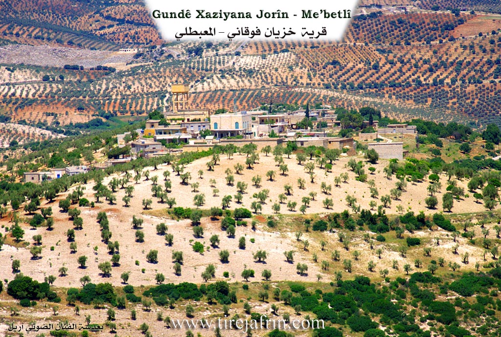
Xaziyan Jorîn is a village in Çiyayê Kurmênc, administratively belonging to the district of Mabeta, in the region of Efrîn, Heleb governorate. It is a small village located in the middle section of the aforementioned mountain, to the south of an elongated limestone plateau extending from the northwest to the southeast. It is furrowed by watercourses and scattered with oak scrub trees. Its soil is clay like. It is located 6 km away from the town of Mabeta towards the west.
It is bordered to the north by the village of Xaziyan Jêrîn at a distance of 100 meters. To the south, it is bordered by a slope, a seasonal valley, mountainous highlands planted with olive trees, and the village of Qişlê. To the west, it is bordered by a slope, a seasonal valley, mountainous highlands planted with olive trees, and the nearby village of Kelanlî. To the east, it is bordered by a slope and a seasonal valley planted with walnut, apple, and olive trees, mountainous highlands, and the village of Ereb Uşaxî.
The number of houses in the village is approximately 45, and its age is approximately 350 years. Its residences are made of stone and mud with flat wooden roofs, while modern cement construction extends towards the northwest. A electricity network, a primary school, and a mosque are available in the village.
The residents cultivate 300 hectares of rainfed land with olives and legumes. Using irrigation from artesian wells, they cultivate summer vegetables and fruit trees, alongside raising sheep and goats. They derive drinking water from cisterns where rainwater collects in winter and from a well dug about 2 km north of the village. A paved road connects the village to the district center, passing near its eastern side to several neighboring villages.
Village Mukhtar: Ismet Ekaş Sîdo.
Sources:
- Book: جبل الكرد (عفرين) دراسة جغرافية Çiyayê Kurmênc (Efrîn): A Geographical Study by د. محمد عبدو علي Dr. Mihemed Ebdo Elî.
- Book: عفرين .... نهرها وروابيها الخضراء Efrîn... Her River and Her Green Hills by عبدالرحمن محمد Ebdulrehman Mihemed from the village of Qetme.
- Studies of Navenda Tirej Soft / Ebdulrehman Hacî Osman.
Preparation and execution:
- Manager of Tirej Efrîn site: Ebdulrehman Hacî Osman
- 20/12/2013
II. Summary of Xaziyanê Jorin and Xazyanê Jêrin from Ax û Welat
Source: https://www.youtube.com/watch?v=iBEaEWY-H1E
The settlement known collectively as Xaziyana is comprised of two distinct villages located in the highlands of the Efrîn region, specifically situated on Çiyayê Xastiya within the broader Mabeta mountain range. The village sits at an elevation of roughly 740 meters, offering views that stretch across the borders of the region. Nearby, the well-known valley Geliya Şiyê runs adjacent to the area, and the stream Çayê Xastiya flows through the landscape. The name Xaziyana is the subject of local debate; some believe it stems from xeza, implying beauty or sweetness, while others suggest it comes from hêvî, meaning a wish or desire.
Historically, the settlement is divided into an upper and a lower village. Xaziyana Jûrin (the Upper Village) is the older of the two. It was founded by two primary families: Mala Bazikê Hemedê Zelxê and Mala Henanê Ûskê. Oral history recounts that Hemedê Zelxê was a patriarch with one son named Bilale and a wife named Helîme. Over time, other families migrated to the upper village and integrated into the community, including Mala Mehmedê Xûce (also referred to as Mala Xûcelera), Mala Ûsivê Feqe, Mala Keleş Hemo, Mala Heso Kûrû, and Mala Seyîd Xeca. Another group, Mala Hevîdo, includes figures such as Silêman and Tacê Selîm.
The lower village, Xaziyana Jêrin, was established later. It was originally called Xaziyana Pûzê Zinêr, named after a prominent black rock cliff (parçek zinar) located to the north of the settlement. The residents of the lower village maintain close ties with the upper village, sharing a cemetery and communal administration. Families in the lower village include Qilîça (later called Mala Ibûyê Kerrîkê), Mala Seydî, Mala Heskî Bilû, Mala Keleş, Mala Kûr Xelîl, and Mala Emîr. Notably, Mala Menanê Heso migrated to the village from Soryo.
The social fabric of Xaziyana has changed over the years. Several families that once resided there, such as Mala Hemzo, Mala Bilkî Şemê, Birîmê Herîrê, Hemîşê Usmên, and Hemoyê Husên, have either died out or moved away entirely. Migration has dispersed the population to Heleb, Şam, and Stenbol. Despite this, the village retains a reputation for high education and culture. The speaker notes that their own family, Mala Mehmedê Xûce, boasts numerous university graduates, and the village produces many doctors, engineers, and pharmacists. The local economy is agrarian, defined by the cultivation of olives, walnuts, apples, almonds, and apricots.
II. Summary of Xaziyanê Jorin and Xazyanê Jêrin from Ax û Welat 2
Source: https://www.youtube.com/watch?v=oR1TZGJ12ew
The village of Xaziya, also known as Xwaziyana, is located on Çiyayê Xastiya in the Mabeta district of the Efrîn region. Divided into two distinct sections, Xaziya Jorîn (Upper) and Xaziya Jêr (Lower), the village sits at an altitude of approximately 740 meters. Locals interpret the name as deriving from beauty (bedewê) or hope, though the lower village was historically distinguished as Xaziya Pûzê Zinêr, named after a prominent rock cliff (zinar) near the settlement.
The settlement history is defined by migration and a transition from cave dwelling to permanent housing. Xaziya Jorîn was the first to be established, founded by two primary lineages: Mala Bazîkê Hemedê Zexê and Mala Henanê Ûskê. Early residents lived in local caves, such as Bena Şehîn and Şikefta Malê Usik Welê, before constructing homes. Xaziya Jêr was founded later by Mala Qirûça (also called Mala Qelûç), who migrated from Şêx Bla in the Reco district. Other families arrived from various locations to form the current community, including Mala Menanê Hesu, who came from Soryo, and Mala Hewîdo, who trace their lineage to Silêman ta ceddê Selîm. Over time, several families such as Mala Hemzo and Birîmê Herîrê have left or disappeared from the village record.
The geography of Xaziya is marked by the famous Geliyê Şiyê valley and fertile plains like Deşta Siyamend and Deşta Bazîkê. Historically, the village economy relied on vineyards, but a shift occurred roughly forty years ago due to disease affecting the vines, leading to the dominance of olive groves today. The village is home to significant historical water sources, most notably the Bîra Romane (Roman Well). This ancient well was a critical resource shared by surrounding villages, including Şêtana, Habu, and Goda. Locals also identify specific springs like Kaniya Hisên and Kaniya Milya Emîr.
Cultural and spiritual life in Xaziya is anchored by local landmarks. A site known as Ziyaret, located in the ruins of Baniya, served as a place of ritual; during droughts, villagers would sacrifice a black chicken there on Fridays to pray for rain. The village retains a strong intellectual tradition, having been home to the renowned storyteller Hemgulîn. Today, it is the residence of the scholar and poet Mihemed Xelîl Emîr and his brother, the writer Mistefa Lêzxan. The community honors its recent history through its institutions, naming the local school after Şehîd Kawa and the commune after Şehîd Dilsoz.
Transcriptions and Subtitles
| Source | Video | Subtitles | Transcript |
|---|---|---|---|
| Ax û Welat 1 | Watch Video | Download SRT | View Transcript |
| Ax û Welat 2 | Watch Video | Download SRT | View Transcript |
Possible Village Name Meaning of Xaziyanê Jorin
Khaziyan: Name of a Kurdish tribe from the large "Mizuri" tribe.
Source: TirejAfrin Site
V. Links
- Tirej Afrin:
https://www.tirejafrin.com/site/kura%20afrin%20%20%20mebetli%20-%20xaziyana%20jorin.htm - Ax û Welat:
https://www.youtube.com/watch?v=iBEaEWY-H1E - Jawlat:
https://www.youtube.com/watch?v=441KeLJvdo0 - Drone:
https://www.youtube.com/watch?v=-Ycz6o34LVE - Video:
https://www.youtube.com/watch?v=cjaHwkjJH8Y - Link:
https://www.youtube.com/watch?v=oR1TZGJ12ew