General Information
Nahiya (Subdistrict)
Mabeta
Also Known As
Khaziyan Tahtani, Xaziyanê Jerin, Xazyan Jerin, خازيان تحتاني
Tribes
Mizûrî, Xaziyan
Families, Clans, etc.
Bako, Bekirê Feqe, Birîmê Herîrê, Hemoyê Husên, Hemîşê Usmên, Mala Bazikê Hemedê Zelxê, Mala Bazîkê Hemedê Zexê, Mala Bilkê Şemê, Mala Bilkî Şemê, Mala Emîr, Mala Hemzo, Mala Henanê Ûskê, Mala Hesen Kûrû, Mala Heskî Bilû, Mala Heso Kûrû, Mala Hevîdo, Mala Hewîdo, Mala Iboyê Meyî Kerîke, Mala Ibûyê Kerrîkê, Mala Isbê Feqe, Mala Kelehme, Mala Keleş, Mala Keleş Hemo, Mala Koleyê, Mala Kûr Xelîl, Mala Kûrxelû, Mala Mehmedê Xûce, Mala Menanê Heso, Mala Menanê Hesu, Mala Pûsa, Mala Qirûça, Mala Seydî, Mala Seydî Bilê, Mala Seyîd Xeca, Mala Xalê 'Ezet, Mala Xûcelera, Mala Ûsivê Feqe, Malê Mistefa, Malê Rûdîn, Qilîça, Seyd Xeca, Êko

Photos
Basic Information about Xazyanê Jêrin
Source: Ax û Welat (Information for Xaziyanê Jorin and Xazyanê Jêrin)
Etymology: Derived from 'xeza' meaning beauty or sweetness, or 'hêvî' meaning wish or desire
Hills: Çiyayê Xastiya, Çiyayê Mabeta, Pûzê Zinêr
Other Landmarks: Geliya Şiyê, Çayê Xastiya, parçek zinar
Summaries
I. Summary from TirejAfrin Site (English) of Xazyanê Jêrin
Source: https://www.tirejafrin.com/site/kura%20afrin%20%20%20mebetli%20-%20xaziyana%20jerin.htm
According to the book Çiyayê Kurmênc (Efrîn): A Geographical Study by Dr. Mihemed Ebdo Elî:
Xaziyan: This is the name of a Kurdish clan belonging to the large Mizûrî tribe. They are two separate villages, Upper and Lower (Jorîn and Jêrîn).
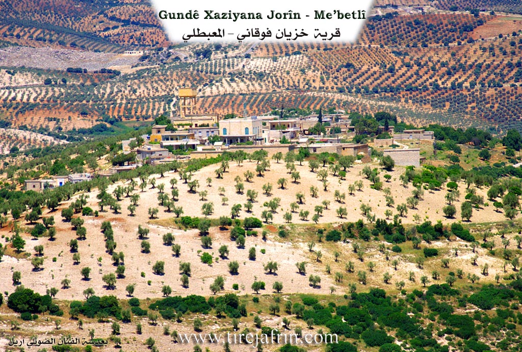
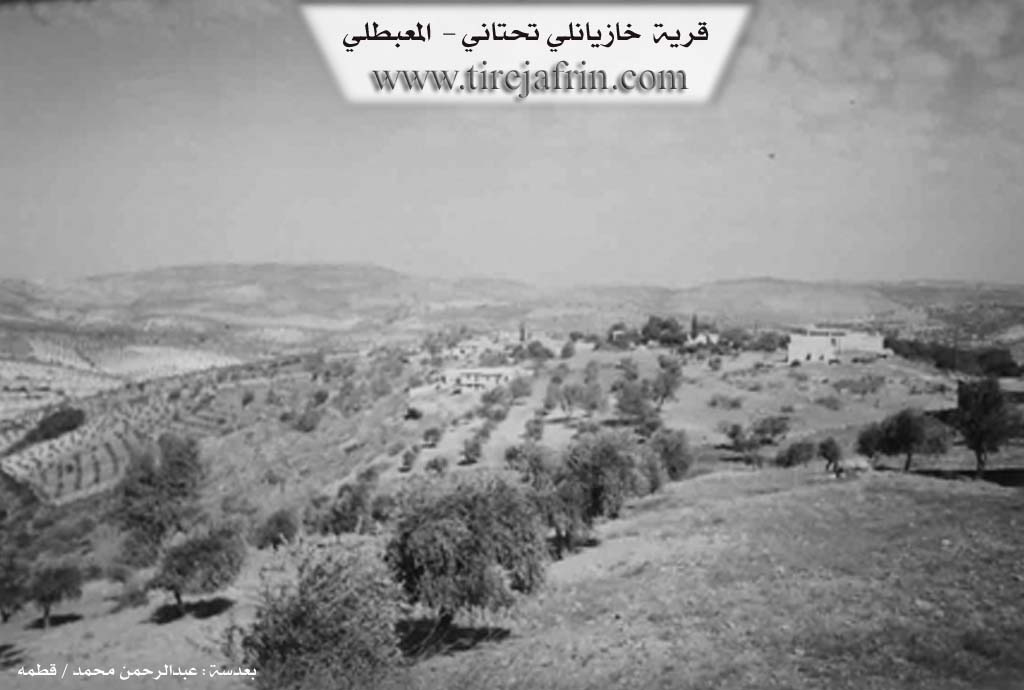
Xaziyan Jêrîn (Lower Xaziyan)
Population: 860. Area: 345 hectares. Distance: 6 km. Elevation: 660 m.
It is a small village situated in a fortified location on a mountain plateau, scattered with pine and oak forests and olive fields.
The book Efrîn... Her River and Her Green Hills by the writer Ebdulrehman Mihemed from the village of Qetme states:
Xaziyan Jêrîn is a village in Çiyayê Kurmênc, administratively belonging to the Mabeta district, Efrîn region, Heleb province. It is a small village located in the central part of the mentioned mountain range, in a fortified position atop a limestone plateau with watercourses. Its soil is clay-like, scattered with oak forests. It is located 6 km to the northwest of the town of Mabeta.
It is bordered to the north by slopes and watercourses planted with olive trees, mountain highlands, and the villages of Rehmaniye and Hemalork. To the south, just meters away, is the village of Xaziyan Jorîn. To the west, there is a slope, the valley of Sîlê, mountain highlands planted with forest trees, and the village of Kelanlî. To the east, there is a slope, the valley of Sîlê planted with olive, apple, and cherry trees, and the village of Ereb Uşaxî.
The number of houses is approximately 45, and the village is about 250 years old. Its old residences are made of stone and mud with flat wooden roofs, while the modern ones are concrete, expanding towards the northwest. A distinctive electricity network is available, as well as a primary school shared with Xaziyan Jorîn and a small mosque. It is connected by a paved road.
The village draws drinking water from cisterns that collect rainwater in winter, and currently from artesian wells. The inhabitants practice rain-fed agriculture (245 hectares) including olives, grains, and legumes. They also practice irrigated agriculture from artesian wells at the bottom of the valley on the eastern side, growing summer vegetables, apple trees, and walnuts, alongside raising sheep and goats.
The most important families mentioned are the Êko and Bako families. Notable figures include:
Dr. Emîr Xan: Author of a German-Kurdish (and vice-versa) dictionary commissioned by the University of Vienna, an Arabic-Kurdish dictionary (2002), and a translation of the Gospel into Kurdish with the approval of Pope Benedict XVI (230,000 index cards for the Arabic-Kurdish dictionary).
Mihemed Xelîl Emîn: Author of The Relationship of the Kurds to the Armenian Massacres (1998) and many manuscripts that have not yet seen the light of day.
Dr. Cemîl Emîr: PhD in the art of decor.
Huseyn Weqas: PhD in Veterinary Medicine/Genetics (Russia).
Dr. Ibrahîm Emîr.
Dr. Derwîş Omer.
There are also many university graduates.
Village Mukhtar: Esmet Ekaş Sîdo
Sources:
- Book: جبل الكرد (عفرين) دراسة جغرافية Çiyayê Kurmênc (Efrîn): A Geographical Study by د. محمد عبدو علي Dr. Mihemed Ebdo Elî.
- Book: عفرين .... نهرها وروابيها الخضراء Efrîn... Her River and Her Green Hills by عبدالرحمن محمد Ebdulrehman Mihemed from the village of Qetme.
- Studies of Navenda Tirej Soft / Ebdulrehman Hacî Osman.
Preparation and Execution:
- Tirej Efrin Site Manager: Ebdulrehman Hacî Osman
- 20/12/2013
II. Summary of Xaziyanê Jorin and Xazyanê Jêrin from Ax û Welat
Source: https://www.youtube.com/watch?v=iBEaEWY-H1E
The settlement known collectively as Xaziyana is comprised of two distinct villages located in the highlands of the Efrîn region, specifically situated on Çiyayê Xastiya within the broader Mabeta mountain range. The village sits at an elevation of roughly 740 meters, offering views that stretch across the borders of the region. Nearby, the well-known valley Geliya Şiyê runs adjacent to the area, and the stream Çayê Xastiya flows through the landscape. The name Xaziyana is the subject of local debate; some believe it stems from xeza, implying beauty or sweetness, while others suggest it comes from hêvî, meaning a wish or desire.
Historically, the settlement is divided into an upper and a lower village. Xaziyana Jûrin (the Upper Village) is the older of the two. It was founded by two primary families: Mala Bazikê Hemedê Zelxê and Mala Henanê Ûskê. Oral history recounts that Hemedê Zelxê was a patriarch with one son named Bilale and a wife named Helîme. Over time, other families migrated to the upper village and integrated into the community, including Mala Mehmedê Xûce (also referred to as Mala Xûcelera), Mala Ûsivê Feqe, Mala Keleş Hemo, Mala Heso Kûrû, and Mala Seyîd Xeca. Another group, Mala Hevîdo, includes figures such as Silêman and Tacê Selîm.
The lower village, Xaziyana Jêrin, was established later. It was originally called Xaziyana Pûzê Zinêr, named after a prominent black rock cliff (parçek zinar) located to the north of the settlement. The residents of the lower village maintain close ties with the upper village, sharing a cemetery and communal administration. Families in the lower village include Qilîça (later called Mala Ibûyê Kerrîkê), Mala Seydî, Mala Heskî Bilû, Mala Keleş, Mala Kûr Xelîl, and Mala Emîr. Notably, Mala Menanê Heso migrated to the village from Soryo.
The social fabric of Xaziyana has changed over the years. Several families that once resided there, such as Mala Hemzo, Mala Bilkî Şemê, Birîmê Herîrê, Hemîşê Usmên, and Hemoyê Husên, have either died out or moved away entirely. Migration has dispersed the population to Heleb, Şam, and Stenbol. Despite this, the village retains a reputation for high education and culture. The speaker notes that their own family, Mala Mehmedê Xûce, boasts numerous university graduates, and the village produces many doctors, engineers, and pharmacists. The local economy is agrarian, defined by the cultivation of olives, walnuts, apples, almonds, and apricots.
II. Summary of Xaziyanê Jorin and Xazyanê Jêrin from Ax û Welat 2
Source: https://www.youtube.com/watch?v=oR1TZGJ12ew
The village of Xaziya, also known as Xwaziyana, is located on Çiyayê Xastiya in the Mabeta district of the Efrîn region. Divided into two distinct sections, Xaziya Jorîn (Upper) and Xaziya Jêr (Lower), the village sits at an altitude of approximately 740 meters. Locals interpret the name as deriving from beauty (bedewê) or hope, though the lower village was historically distinguished as Xaziya Pûzê Zinêr, named after a prominent rock cliff (zinar) near the settlement.
The settlement history is defined by migration and a transition from cave dwelling to permanent housing. Xaziya Jorîn was the first to be established, founded by two primary lineages: Mala Bazîkê Hemedê Zexê and Mala Henanê Ûskê. Early residents lived in local caves, such as Bena Şehîn and Şikefta Malê Usik Welê, before constructing homes. Xaziya Jêr was founded later by Mala Qirûça (also called Mala Qelûç), who migrated from Şêx Bla in the Reco district. Other families arrived from various locations to form the current community, including Mala Menanê Hesu, who came from Soryo, and Mala Hewîdo, who trace their lineage to Silêman ta ceddê Selîm. Over time, several families such as Mala Hemzo and Birîmê Herîrê have left or disappeared from the village record.
The geography of Xaziya is marked by the famous Geliyê Şiyê valley and fertile plains like Deşta Siyamend and Deşta Bazîkê. Historically, the village economy relied on vineyards, but a shift occurred roughly forty years ago due to disease affecting the vines, leading to the dominance of olive groves today. The village is home to significant historical water sources, most notably the Bîra Romane (Roman Well). This ancient well was a critical resource shared by surrounding villages, including Şêtana, Habu, and Goda. Locals also identify specific springs like Kaniya Hisên and Kaniya Milya Emîr.
Cultural and spiritual life in Xaziya is anchored by local landmarks. A site known as Ziyaret, located in the ruins of Baniya, served as a place of ritual; during droughts, villagers would sacrifice a black chicken there on Fridays to pray for rain. The village retains a strong intellectual tradition, having been home to the renowned storyteller Hemgulîn. Today, it is the residence of the scholar and poet Mihemed Xelîl Emîr and his brother, the writer Mistefa Lêzxan. The community honors its recent history through its institutions, naming the local school after Şehîd Kawa and the commune after Şehîd Dilsoz.
II. Summary of Xazyanê Jêrin from Khalil Sino
Source: https://www.youtube.com/watch?v=CYmVSbymuQw
The documentary captures a visit to the village of Xozyana jêr in the Efrîn region, specifically focusing on the preservation of traditional culinary customs and social bonds within the home of Xalê 'Ezet. The host, Xelîl from the village of Be'dîna (representing the channel Hatim Efrîn), joins the residents to document their way of life, distinct from the neighboring Xozyana jor. While the transcript does not provide specific founding dates or tribal origins, it offers a detailed look at the domestic economy and social structure of the village through the lens of its elders.
The central narrative revolves around the seasonal preparation of winter provisions. Xaltîka Hemîde, the matriarch of the household, details the labor-intensive process of harvesting and drying local produce. She explains how figs (hejîr), almonds (be'îv), and walnuts (gûz) are collected, peeled, and dried on rooftops (serê xênî) to ensure food security during the winter. She also describes the production of bastêq (fruit leather) and the collection of benîşt (gum) from trees. The villagers lament that while these practices continue, the abundance and quality of ingredients like natural honey (hingiv) and butter (rûnê nivîşkî) have declined compared to the "old days" (zemanê berê), which they view as a healthier and more prosperous era.
A significant portion of the gathering is dedicated to cooking hesîde, a traditional dessert made from flour, oil, and grape molasses (dimisî rezan). Xaltîka Hemîde and Xaltîka Fîdan prepare the dish over a gas stove, noting that it was historically cooked over wood fires. The preparation serves as a social event, accompanied by Xalê Mihemed, a 94-year-old resident. Despite his advanced age, Xalê Mihemed plays the tembûr for the guests, serving as a living link to the village's cultural past.
The social fabric of Xozyana jêr is revealed to be deeply interconnected but geographically dispersed. The gathering concludes with an extensive series of greetings sent to family members living in the diaspora, specifically mentioning relatives in Heleb (Aleppo) and Şimalê Êraqê (Northern Iraq). The speakers send blessings to numerous individuals and families, including Malê Mistefa and Malê Rûdîn, as well as specific relatives such as Wehîdê, Leylê, Bilind, and Sûlîn. This roll call of names highlights the enduring connections between the residents of Xozyana jêr and their kin who have moved away, maintaining village unity despite physical separation.
Transcriptions and Subtitles
| Source | Video | Subtitles | Transcript |
|---|---|---|---|
| Ax û Welat 1 | Watch Video | Download SRT | View Transcript |
| Ax û Welat 2 | Watch Video | Download SRT | View Transcript |
| Khalil Sino 1 | Watch Video | Download SRT | View Transcript |
Possible Village Name Meaning of Xazyanê Jêrin
Khaziyan: Name of a Kurdish tribe from the large "Mizuri" tribe.
Source: TirejAfrin Site
V. Links
- Tirej Afrin:
https://www.tirejafrin.com/site/kura%20afrin%20%20%20mebetli%20-%20xaziyana%20jerin.htm - Drone:
https://www.youtube.com/watch?v=-Ycz6o34LVE - Video:
https://www.youtube.com/watch?v=cjaHwkjJH8Y - Ax û Welat:
https://www.youtube.com/watch?v=iBEaEWY-H1E - Ax û Welat:
https://www.youtube.com/watch?v=oR1TZGJ12ew - Khalil Sino:
https://www.youtube.com/watch?v=CYmVSbymuQw