General Information
Nahiya (Subdistrict)
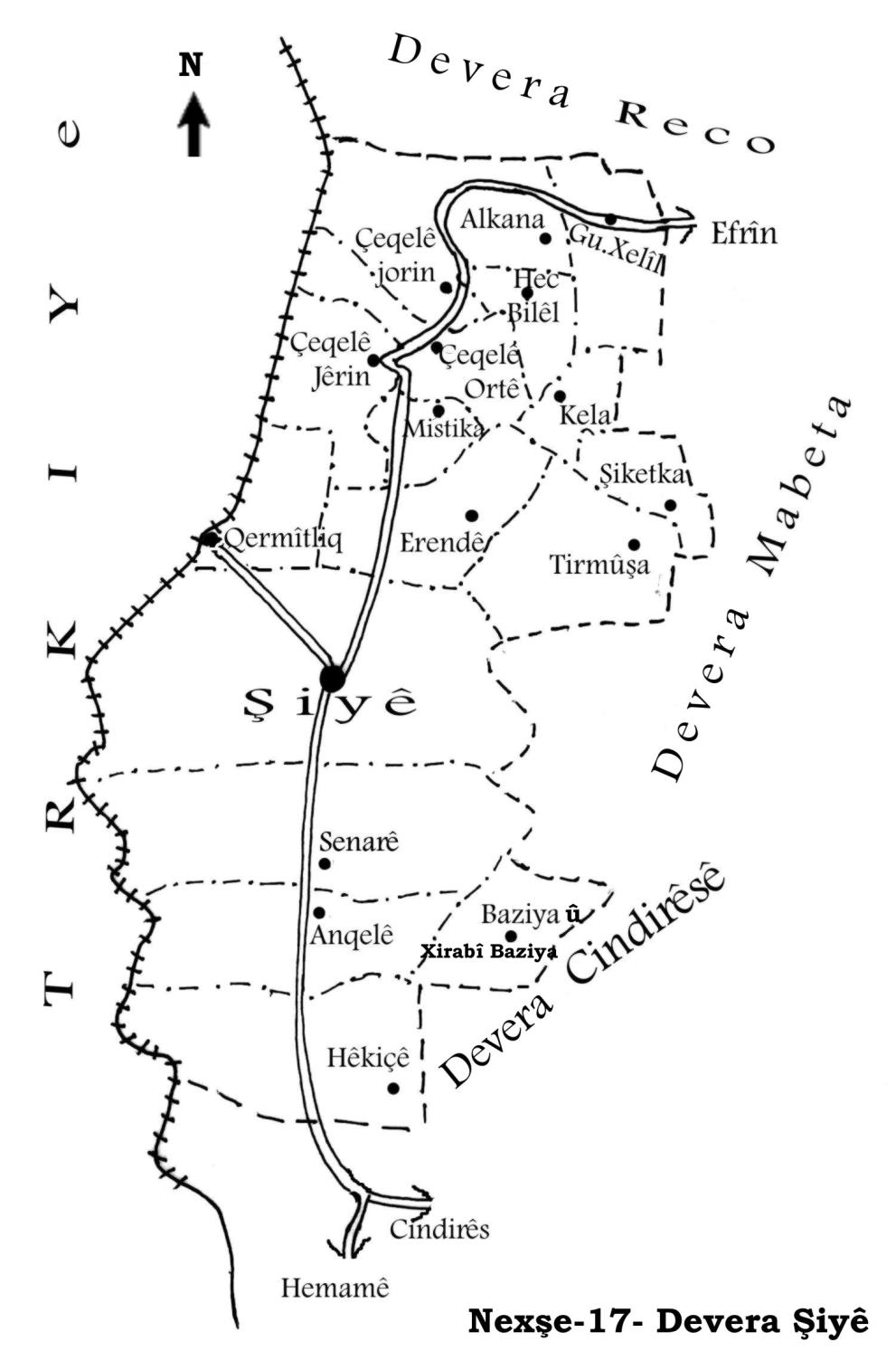
Şiyê
Also Known As
Al-Wardiya, Mile Xelîla, Khalil Kolko, Kolka, Xelîl, الوردية, خليل كولكو, خليل, كونده خليل
Families, Clans, etc.
Delî, Elî Elcaro, Mala Apê Fîlik, Mala Hecî Xelîl, Mala Hisên, Mala Zêva, Malê Mîşkê, Malê Xoce, Mele Arfî Çolê, Xelîl Gulkê
Photos
Basic Information about Xelîl
Source: Ax û Welat
Etymology: Named after Xelîl, one of the two founders who settled there
Foundation Date/Period: Approximately 300 to 350 years ago
Hills: Çiyayê Ziyaretê, Çaqê
Shrines: Merqeda Ebdurehman, Ziyareta Ebdurehman
Ruins: Davûheft xonî
Wells: Bîra Kufarde
Other Landmarks: Deşta Şiyê, Deşta Çeqela
Summaries
I. Summary from TirejAfrin Site (English) of Xelîl
Source: https://www.tirejafrin.com/site/kura%20afrin%20%20%20shiye%20-%20kalil%20kolko.htm
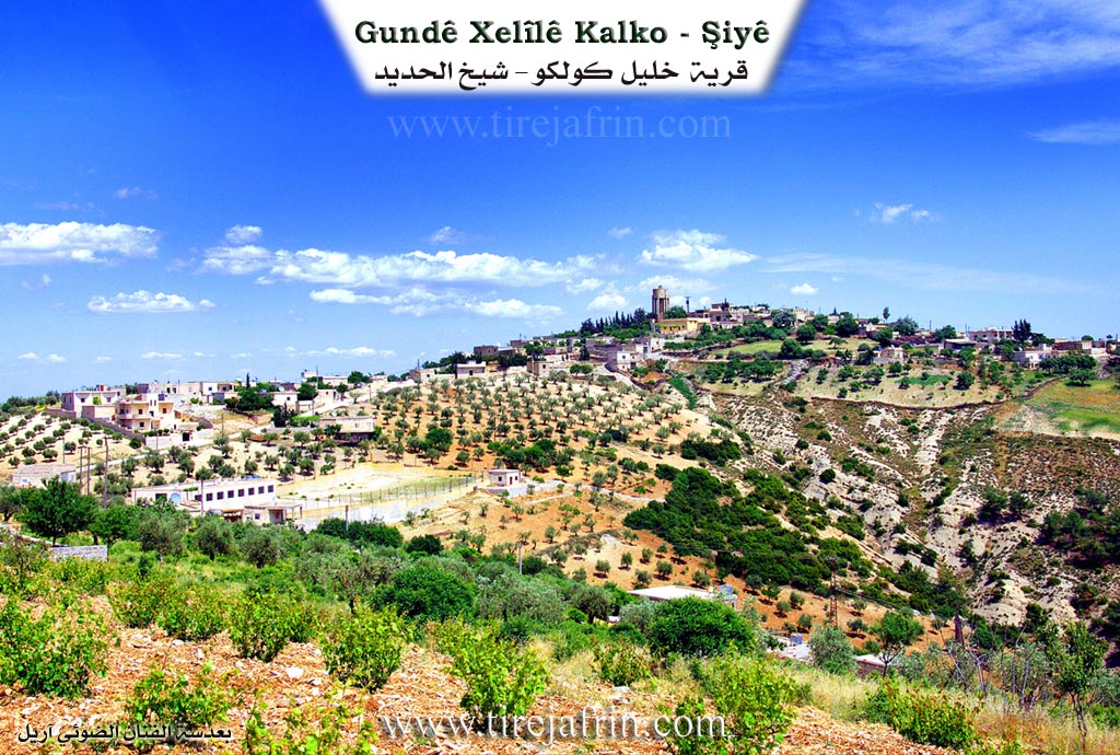
It is stated in the book جبل الكرد (عفرين) دراسة جغرافية Çiyayê Kurmênc (Efrîn): A Geographical Study by د. محمد عبدو علي Dr. Mihemed Ebdo Elî regarding Gund Xell, Xelîl Kolko, El-Werdiyê (1455 inhabitants, 407 hectares, 15km distance, 831m altitude):
Xelîl is a local proper name. As for the word Kolko, it is a diminutive of the word Gul meaning the rose, and it is a nickname for one of its early residents, perhaps in relation to the name of his mother Gul, which is a local female Kurdish proper name. The name was Arabized to El-Werdiyê based on that nickname. It is a large village located on the summit of Çiyayê Ziyaret.
It is stated in the book عفرين .... نهرها وروابيها الخضراء Efrîn... Her River and Her Green Hills by the writer عبدالرحمن محمد Ebdulrehman Mihemed from the village of Qetme regarding Xelîl Kolko:
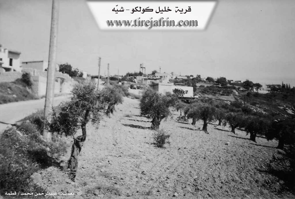
It is a village in Çiyayê Kurmênc, administratively belonging to the Şiyê district, Efrîn region, Heleb governorate. It is a large village located in the western central part of the mentioned mountain block, on a high limestone summit (Çiyayê Ziyaret) and at the beginning of a deep watercourse heading north. It is 15km away from the town of Şiyê towards the northeast.
It is bordered to the north by a mountain chain, several watercourses, and the village of Memila; to the south by a rugged and harsh slope, a deep watercourse, and the village of Kêla; to the west by a deep valley and the village of Alkana Satiyan; and to the east by a slope planted with olive trees and the village of Hemalîk El-Delfe.
The number of its houses reaches approximately 125 houses, and its age is approximately 400 years. An electricity network and a state owned water network are available in it, as well as a modern joint primary and preparatory school shared with the village of Satiyan. It contains an old mosque and two modern technical olive presses.
The residents work in rain fed agriculture (olives, grains, legumes, figs, vines, walnuts, almonds) on an area of 407 hectares. Olive trees constitute 75% of this. In addition, they raise livestock. The water of the village comes from rain collected in cisterns dug next to the houses or from springs neighboring the village. It is connected to the district center and neighboring villages by a winding asphalt road.
The village mukhtar is Ebdulmelik Delî.
Sources
Book: جبل الكرد (عفرين) دراسة جغرافية Çiyayê Kurmênc (Efrîn): A Geographical Study by د. محمد عبدو علي Dr. Mihemed Ebdo Elî.
Book: عفرين .... نهرها وروابيها الخضراء Efrîn... Her River and Her Green Hills by عبدالرحمن محمد Ebdulrehman Mihemed from the village of Qetme.
Preparation and Execution:
Director of Tirej Efrîn site: Ebdulrehman Hacî Osman
20/12/2013
II. Summary of Xelîl from Ax û Welat
Source: https://www.youtube.com/watch?v=e8Hmdh3Wwr8
The village of Gundê Xelîl, located on the high peaks of Çiyayê Ziyaretê in the Şiyê district of Afrin, was established approximately 300 to 350 years ago. The village stands at an altitude of 1300 meters, making it one of the highest settlements in the region. Its history begins with two founding figures, Xelîl (specifically Xelîl Gulkê) and his brother or close companion Elî (known as Elî Elcaro). According to village elder Salih Hebîb Cemal, these men originated from Adiyaman and fled following a failed rebellion against the Ottomans during the era of Sultan Selim. After six brothers were captured or killed, the remaining survivors escaped toward the Efrîn region.
Initially, the founders settled in the low lying plains known as Deşta Şiyê or Deşta Çeqela. However, the area was plagued by insects and illness. A woman named Me'mela refused to stay in the plains, urging the group to move to the mountaintop for better health and defense. Consequently, Xelîl and Elî established the village on the summit. To protect themselves from bandits and raids, they constructed a defensive housing complex known as Davûheft xonî, where seven houses were interconnected, allowing residents to move between homes without stepping outside. The village eventually took the name of Xelîl, while Elî Elcaro settled beside him. Later waves of migration brought other families, including Malê Xoce from Xarpêt (Harput) and Malê Mîşkê from Kela.
The spiritual center of the village is the Merqeda Ebdurehman, also referred to as Ziyareta Ebdurehman. This shrine reportedly dates back 350 years, potentially pre dating the village's full settlement or established by the founders upon their arrival. Locals believe the shrine emits a deep groaning sound and serves as a site for healing prayers and rain summoning rituals during droughts. Another historical landmark is Bîra Kufarde, an ancient well located between Gundê Xelîl and the neighboring Me'mela, which served as a vital water source in the past.
Culturally, the village is noted for its resilience against harsh winters, where snow can reach two meters high, requiring neighbors to dig each other out. It preserves unique traditions such as the Şaqûle, a ceremony for one year old children involving a bag of sweets and fruit to ensure the child does not fall often while learning to walk. Gundê Xelîl also prides itself on education; a school was built jointly with the villages of Alkana and Hec Bîlêl in 1953. In more recent times, the village became the site of the first Heyva Sor (Kurdish Red Crescent) center in the area, established to serve several surrounding villages. Residents like Apê Fîlik continue to maintain traditional crafts, creating wooden tools and saddles, preserving the self sufficient spirit of this mountain community.
Transcriptions and Subtitles
| Source | Video | Subtitles | Transcript |
|---|---|---|---|
| Ax û Welat 1 | Watch Video | Not Available | View Transcript |
Foundation/Origin Information of Xelîl
The founders, Xelîlê Golkê and Elîcaro, were part of a group of fifty Kurds who escaped oppression after a failed revolution in the Amed and Mêrdîn regions of North Kurdistan during the era of the Ottoman Sultan Selim. The survivors settled on a mountain that was already a sacred site known as Çiyayê Ziyaretê and built their first homes around it.
Source: Ax û Walat Transcript
Possible Village Name Meaning of Xelîl
"Khalil" is a local proper name. The word "Kolko" is a diminutive form of the word "Gul" meaning rose, which is a nickname for one of its early inhabitants, possibly in relation to his mother's name Gulê. The name was Arabized to "Al-Wardiya" in reference to that nickname.
Source: TirejAfrin Site
The village was ultimately named after Xelîl, one of its founders.
Source: Ax û Walat Transcript
V. Links
- Tirej Afrin:
https://www.tirejafrin.com/site/kura%20afrin%20%20%20shiye%20-%20kalil%20kolko.htm - Ax û Welat:
https://www.youtube.com/watch?v=cPzfHaX_zqE - Local FB page:
https://www.facebook.com/profile.php?id=100052679717662 - Video:
https://www.youtube.com/watch?v=BVZ1qrgpQGI - Ax û Welat:
https://www.youtube.com/watch?v=e8Hmdh3Wwr8