General Information
Nahiya (Subdistrict)
Reco
Also Known As
Al-Saluk, Xirab Siluk, Xirabê Sûlik, Xirabî Silûg, السلوك، خرابة سلوكي, خراب سلوك, خرابه سلوك
Tribes
Şêxî
Families, Clans, etc.
Malê Hisko, Malê Mehmûdê Lalo, Malê Mihemedî Eto, Malê Mistoyê Lalo, Malê Topalê Lalo, Malê Şêx Çûçê

Photos
Basic Information about Xirabî Silûg
Source: Ax û Welat
Etymology: Named after leeches (sûlik) used for healing by a woman who frequented the ruins (xirabe) at the site
Foundation Date/Period: Approximately 150 years ago
Springs: Kaniya Hîşirkê
Hills: Çiyayê Ebdilezîz
Shrines: Ziyaretgeha Miste Dêrwîş
Ruins: Xirabê Sûlik
Wells: Bîra Hebîlong
Other Landmarks: Ava Reş, Çemê Reş, Geliyê Bekê, Qula Kiprî, Deşta Xarê, Gunchiyê
Summaries
I. Summary from TirejAfrin Site (English) of Xirabî Silûg
Source: https://www.tirejafrin.com/site/kura%20afrin%20%20%20Reco%20-%20xarb%20salok.htm
It is stated in the book Çiyayê Kurmênc (Efrîn): A Geographical Study: Xirab Silg, Xirab Silûk, El-Silûk /417 inhabitants - 440m/:
Silûk: The name of a woman by whom the location of the village was known. The Arabized name adopted half of the basic name.
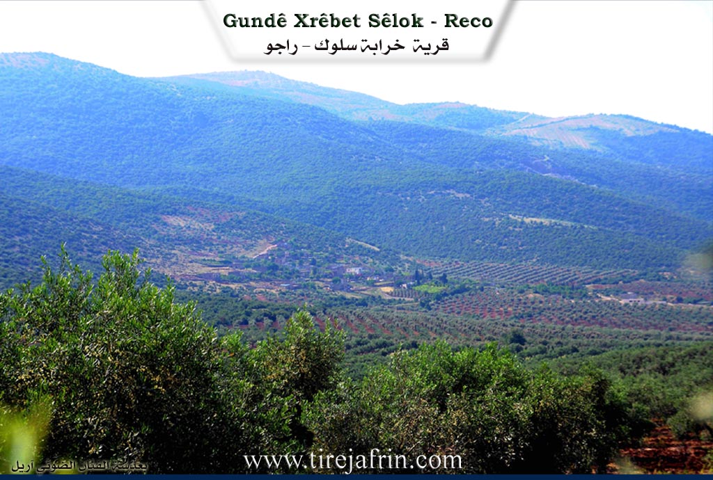
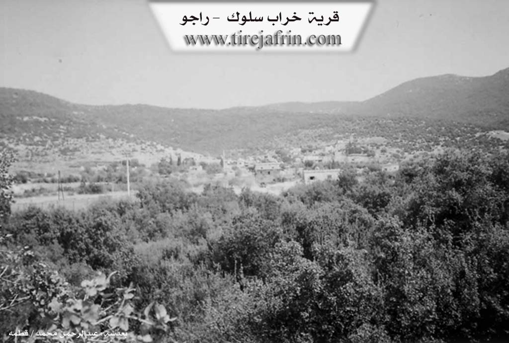
It is a small village located on the western slopes of Bilalîko mountain. It is 3km away from the Turkish border. It is surrounded by a large forest of oak trees, and the railway line passes beside it.
It is stated in the book Efrîn... Her River and Her Green Hills: Xirab Silûk is a farm (mezra) in Çiyayê Kurmênc belonging to the Reco district, Efrîn region, Heleb governorate. It is a small farm belonging to the village of Bilalîko, located in the western part of Çiyayê Kurmênc at the bottom of a wide and fertile plain and the Riya Giştî ya Meydan Ekbez-Reco (Meydan Ekbez-Reco public road).
It is bordered to the north by a rugged mountain range, the plain of Meydan Ekbez, and the village of Meydan Ekbez. It is bordered to the south by a plain, the Xeta Hesinî ya Reco-Meydan Ekbez (Reco-Meydan Ekbez railway line), and the village of Ferferîk Tehtanî. To the west, it is bordered by a slope, a plain, the Riya Reco-Meydan Ekbez (Reco-Meydan Ekbez road), and the village of Qere Baba. To the east, it is bordered by a high mountain range called Çiyayê Meydaniyat, planted with forest trees belonging to state properties, and the villages of Elî Beskî and Cehenkelî.
The number of its houses reaches about 35 houses, and its age is about 50 years. Its old dwellings are made of stone and mud with flat wooden roofs, while the modern ones are cement and are spreading towards the west. An electricity network is available, as well as a drinking water network from a drilled well in the village belonging to the state, and a modern primary school.
It connects with the public road leading to Meydan Ekbez and the town of Reco via an unpaved dirt road. The residents work in rain-fed agriculture (olives, vines, fruit trees) alongside raising sheep and goats.
Sources:
- Book: جبل الكرد (عفرين) دراسة جغرافية Çiyayê Kurmênc (Efrîn): A Geographical Study by د. محمد عبدو علي Dr. Mihemed Ebdo Elî.
- Book: عفرين .... نهرها وروابيها الخضراء Efrîn... Her River and Her Green Hills by عبدالرحمن محمد Ebdulrehman Mihemed from the village of Qetme.
- Studies of Navenda Tirej Soft / Ebdulrehman Hacî Osman.
- Some residents of the villages.
Preparation and execution: Manager of the Tirej Efrîn site: Ebdulrehman Hacî Osman 20/12/2013
II. Summary of Xirabî Silûg from Ax û Welat
Source: https://www.youtube.com/watch?v=yXLs3DuXs3E
History and Origins
The village of Xirabê Sûlik, situated in the Recû district of the Efrîn region, takes its name from a distinctive local history of traditional healing. According to village elders, the site was originally a ruin (xirabe) frequented by a woman from Qirxê, sometimes referred to as Zêrî. She utilized water leeches, known as sûlik in Turkish and the local dialect, to treat patients suffering from various ailments. Because she would stay among the ruins to perform these cures, the location became known as Xirabê Sûlik. The village itself was founded approximately 150 years ago, a timeline supported by a 105 year old resident who noted the settlement existed before his birth. The first settler was a man named Hisko, who built a house among the ruins. The original inhabitants were primarily from the nearby village of Bilêlkê, who initially used the land for seasonal farming and grazing before establishing permanent homes.
Social Structure and Life
The population of Xirabê Sûlik is predominantly from the Şêxî tribe. The community is comprised of several distinct families, including Malê Mistoyê Lalo, Malê Mehmûdê Lalo, Malê Topalê Lalo, and Malê Mihemedî Eto. There is also an Arab family known as Malê Şêx Çûçê or Malê Ereb. Residents maintain close ties with neighboring villages such as Bilêlkê, Elbîskê, and Qerebaba. The village economy relies heavily on agriculture, utilizing water from Ava Reş (also referred to as Çemê Reş) to irrigate crops like olives, wheat, lentils, and vegetables. A notable figure in the village's modern development was Hecî Behrî, a respected elder credited with bringing electricity to the village roughly 20 years ago.
Sacred Sites and Landmarks
Significant landmarks define the geography around Xirabê Sûlik. The Ziyaretgeha Miste Dêrwîş is an ancient shrine that now serves as the shared cemetery for Xirabê Sûlik, Qerebaba, and Gundê Şêx. Water sources play a vital role in the village's history, particularly Kaniya Hîşirkê, a spring located to the west where villagers formerly fetched drinking water and washed clothes. Another historical water source mentioned by elders is Bîra Hebîlong. To the north, the terrain features Geliyê Bekê and Qula Kiprî.
Cultural Heritage
Xirabê Sûlik is renowned for its connection to the Kurdish bardic tradition. The village was home to the celebrated dengbêj Huseynê Hêydê Topo, who passed away in 1995. He learned his art from a shepherd named Osmanê Berazî from the Kêtka tribe while herding in Bilêlkê. Huseynê Hêydê Topo was known for performing classic songs like Ayşê, Delal, and Meyremê at weddings and social gatherings. His legacy is preserved by his son, Mistefa, who continues to sing the traditional songs passed down by his father. The village also honors several local martyrs, including Şehîd Dilbirîn and Şehîd Edhem, whose names adorn local institutions.
Transcriptions and Subtitles
| Source | Video | Subtitles | Transcript |
|---|---|---|---|
| Ax û Welat 1 | Watch Video | Download SRT | View Transcript |
Foundation/Origin Information of Xirabî Silûg
Established on the site of pre-existing ruins that were once inhabited by Arabs and a group known as the Mecî. The current inhabitants' ancestors migrated from the village of Bilbilkê, initially practicing seasonal agriculture before being permanently displaced from their original mountain homes by "the Turks".
Source: Ax û Walat Transcript
Possible Village Name Meaning of Xirabî Silûg
Silug: The name of a woman for whom the village site was known. The Arabized name took half of the original name.
Source: TirejAfrin Site
Its name originates from a Turkish woman named Zêrê who lived among the ruins and was known for treating illnesses with leeches (sûlik); originally called "Xirabê Pîrê Zêrê" (Ruins of the old woman Zêrê), the name was eventually shortened to "Xirabê Sûlik."
Source: Ax û Walat Transcript