General Information
Nahiya (Subdistrict)
Bilbilê
Also Known As
Z'arê, Za'rah, Za'reh, Zarê, Ze'rê, Zearê, Zere, Zerna, زعرة, زعره
Tribes
Hesenî, Mertebanî
Families, Clans, etc.
Alîko, Alûlera, Elûlera, Mala Alîkê, Mala Cimo, Mala Hamskê, Mala Reşko, Malê Alîkêna, Malê Hamskê, Malê Reşko

Photos
Basic Information about Ze'rê
Source: Ax û Welat
Foundation Date/Period: over 300 years ago
Springs: Kaniya Mola Cimo, Kaniya Çinarê, Kaniya Hesen, Kaniya Qîskê, Kaniya Kûrkê, Kaniya Gûlê Beqçê
Hills: Zûyê
Shrines: Ziyareta Çûçik, Sehabê Çûçik
Ruins: Xanê Kabîl
Other Landmarks: Aşê 'El Kûrê, Qulbêyê
Summaries
I. Summary from TirejAfrin Site (English) of Ze'rê
Source: https://www.tirejafrin.com/site/kura%20afrin%20%20%20bilbile%20-zare.htm
According to the book جبل الكرد (عفرين) دراسة جغرافية Çiyayê Kurmênc (Efrîn): A Geographical Study, the village is named Ze'r, Ze're, or Ze're. It has 1611 inhabitants, covers 250 hectares, is located 3 kilometers away, and sits at an elevation of 900 meters.
Regarding the etymology, "Zer" means mountain, mount, or high place as stated in Ferhenga Kurranî, and this corresponds to the location of the village. However, Xûrî Bersûm states that it is Aramaic, meaning small, short, or narrow, but this is far from being the source of its name. El_Esedî also mentioned that it comes from the Aramaic word Z'ûra, meaning "The Small."
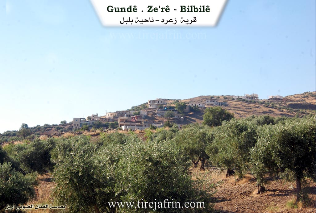
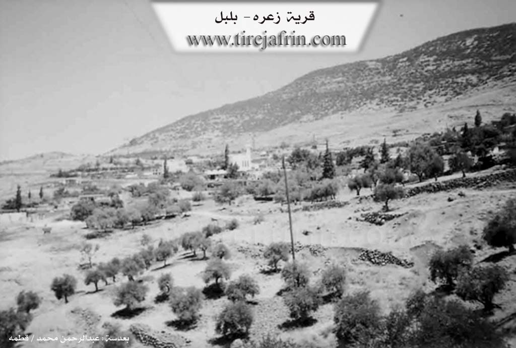
It is a small village located west of the town of Bilbil in the middle of the southwestern slope of the mountain Gir Mezin (Big Hill), and it contains a border outpost.
According to the book عفرين .... نهرها وروابيها الخضراء Efrîn... Her River and Her Green Hills, Ze're is a village in Çiyayê Kurmênc following the sub district of Bilbil, area of Efrîn, governorate of Heleb. It is a medium sized village located on the lower western slope, which has a slight incline, of Mount Damrik. It sits in the embrace of a depression and a valley in the middle of the western side. It is 3 kilometers away from the town of Bilbil towards the northwest. It is bordered to the north by the high Mount Damrik, behind which lies the Turkish border directly at a distance of 1 kilometer. To the south, it is bordered by slopes, a torrential valley, and a wide valley between them and the village of Xidryanlî. To the west, there is a torrential valley and the village of Hayamlî. To the east, there is the peak of Damrik, the town of Bilbil, and Qurne.
The number of houses in the village is approximately 70, and its age is about 400 years. Its old houses are made of stone and mud with flat wooden roofs made of black volcanic basalt stones, while the modern ones are cement and have expanded towards the south and east. An electricity network, telephone network, and drinking water are available. The water comes from a well connected to the south with the town of Bilbil or from cisterns where rainwater is collected. The village has a primary school and a very beautiful modern mosque built from white stones.
Most of its inhabitants work in the cultivation of olives, grains, and vines through rain fed farming on 200 hectares, and summer vegetables and fruit trees via irrigation from artesian wells on an area of 12 hectares. In addition to raising sheep and goats, some residents work in the neighboring marble quarries. A paved road connects it to the sub district center, passing through its center to several neighboring villages. Natural trees such as oak, cypress, and forest trees are abundant there. The village also contains a border outpost.
The village Mukhtar is Mistefa Elî Êbo.
Sources
Book: جبل الكرد (عفرين) دراسة جغرافية Çiyayê Kurmênc (Efrîn): A Geographical Study by د. محمد عبدو علي Dr. Mihemed Ebdo Elî.
Book: عفرين .... نهرها وروابيها الخضراء Efrîn... Her River and Her Green Hills by عبدالرحمن محمد Ebdulrehman Mihemed from the village of Qetme.
Studies of Navenda Tirej Soft / Ebdulrehman Hacî Osman.
Some residents of the villages.
Preparation and execution: Manager of the website Tirej Efrîn: Ebdulrehman Hacî Osman 20/12/2013
II. Summary of Ze'rê from Ax û Welat
Source: https://www.youtube.com/watch?v=se6idLNbGo8
The village of Ze'rê, situated in the Bilbil district of Çiyayê Kurmênc (the mountain of the Kurds), is a historic settlement located just two kilometers from the artificial border separating Syria and Turkey. Founded over 300 years ago, the village rests on the slopes of the prominent hill known as Zûyê. According to village elder Apê Hecî, the first settlers were Malê Hamskê, followed by Malê Alîkêna and Malê Reşko. While Malê Hamskê eventually dispersed and vanished from the village, the Alûlera family later arrived, joining the remaining lineages. Today, the village is primarily composed of three main families: Alîko, Malê Reşko, and Alûlera.
The history of Ze'rê is deeply marked by the drawing of the border in the early 20th century, which severed the community from their relatives and lands in the north. Residents have kin in Kilis, Çerçiyê, Pelûlê, Pêrt, Cûqa, Bawûxê, and Mam Ereba. Elders recall a time when Efrîn did not exist as a city; instead, their economic hubs were Ezaz and Kilis. A historical landmark, Xanê Kabîl, once served as a caravanserai where camel drivers traveling through the region would stop to eat and feed their animals before continuing to Kilis or Entab. The imposition of the border confiscated approximately 50 hectares of village land and created a minefield that has injured at least ten villagers over the years. Apê Hecî recounts the lament of his cousin, Reşxêl, who wept when the border was established, predicting that future generations would eventually lose their familial connections—a fear that has largely come to pass.
Despite these hardships, Ze'rê is renowned for its water sources and communal spirit. The village boasts around seven or eight springs, including Kaniya Mola Cimo, Kaniya Çinarê, Kaniya Hesen, Kaniya Qîskê, and Kaniya Kûrkê, which historically provided ample water for the residents. Before modern transportation, villagers relied on donkeys to carry grain to Aşê 'El Kûrê (The mill of El Kûrê). The village retains strong social cohesion, particularly during Cejna Qurbanê (Eid al-Adha), when the entire community gathers to share meals, maintaining a tradition that has faded in many other places.
Religious and cultural life in Ze'rê centers around the ancient Ziyareta Çûçik (also called Sehabê Çûçik). Dating back more than 300 years, this shrine is a site for healing rituals where visitors tie strips of cloth (paçik) to the site or drive stakes into the ground to cure ailments. It is also a focal point for rain prayers and seasonal celebrations where villagers cook and eat together. The documentary also highlights the preservation of heritage through residents like Dya Emmar, who collects antique items like the hekîb (saddlebags), and the continued presence of traditional trades, exemplified by Xelo, a traveling shoemaker and singer from the village of Nazam, who keeps the musical legacy of figures like Hes Nazî alive in the region.
II. Summary of Ze'rê from Ax û Welat 2
Source: https://www.youtube.com/watch?v=9wQysLHT2pg
The village of Zerê is located in the Bilbil district of the Efrîn canton in the Çiyayê Kurmênc region. Situated directly on the border line (ser xetê) between Syria and Turkey, the village is approximately 3 kilometers from the town of Bilbil. According to village elder Hecî Mistefa, Zerê was founded over 300 years ago. The first inhabitants were the Mala Hamskê family, though they have since scattered and no longer reside there. They were followed by the Mala Alîkê and Mala Reşko families, and later the Elûlera family. These three groups currently constitute the three main lineages (sê ocaq) of the village.
The history of Zerê is deeply defined by the imposing of the border in the early 20th century. Residents maintain close kinship ties with villages now located across the border in Northern Kurdistan, such as Kilûrê, Çerçiya, Pelûla, Pîrta, Cûqa, Bowixê, Mam-Ereba, and Gundê Ecema. Elders recall a time before the border when they traveled freely to trade in Kilis and Ezaz, stopping at the Xana Kebûl regarding trade routes. Hecî Mistefa recounts a story of his grandfather, Reşkel, weeping when the border was established, predicting that future generations would become strangers to their own kin. The physical reality of this separation is marked by landmines; one elder notes that ten people from the village lost their limbs due to mines planted in the agricultural lands that were cut off from access.
Geographically, Zerê is renowned for its water resources, boasting seven or eight springs including Kaniya Mala Cimo, Kaniya Hesen, Kaniya Qîskê, and Kaniya Kurkê. These springs have historically sustained the village and its livestock. The village landscape includes hills such as Zûyê Giran and Herî-bilind, and residents recall a historical mill known as Aşê Elkurê.
Culturally, Zerê is distinguished by its preservation of communal traditions that have faded in other parts of the region. During Cejna Qurbanê (Eid al Adha), the entire village gathers to share meals together, a custom emphasized by residents like Ebdurehman as a symbol of their unity. The village is also home to a shrine known as Sehabê Çûçik, estimated to be 300 to 400 years old. Locals visit this site for healing rituals and to pray for rain during droughts. Notable figures in the documentary include Dya Emmar, a curator of local antiques, and Xelû, a traveling shoemaker and singer from the neighboring village of Naza, which is famous for producing artists like Hesen Nazî and Evdê Şe'rê.
Transcriptions and Subtitles
| Source | Video | Subtitles | Transcript |
|---|---|---|---|
| Ax û Welat 1 | Watch Video | Not Available | View Transcript |
| Ax û Welat 2 | Watch Video | Download SRT | View Transcript |
Foundation/Origin Information of Ze'rê
Originally founded by three families—Malê Alîkê, Malê Reşko, and Malê Hemskê—who migrated from Çiyayê Kurmênc (Kurd Mountain).
Source: Ax û Walat Transcript
According to village elders, it was originally founded at a site named Xirabê Xulî by three families—the Hemsikê, Reşko, and Elîko—before they relocated to the current site near a spring, later being joined by the Alûlaro family.
Source: Ax û Walat Transcript
Possible Village Name Meaning of Ze'rê
Zer means mountain, hill, mound as mentioned in /Kurdish Dictionary/. Al-Khouri Barsoum says it is Aramaic meaning: small, short, narrow. According to Al-Asadi, it comes from Aramaic: Zə'ura: the small one.
Source: TirejAfrin Site