General Information
Nahiya (Subdistrict)
Şera
Also Known As
Cema, Jaman, Jamanli, Çema, اورمارو, جمان, جمانلي, چمانلي, جامو
Tribes
Çema
Families, Clans, etc.
Hemoloro, Hesento, Hespisîyo, Mala Elî Şan, Mala Elî Şêr, Mala Hemê, Mala Hemîkê, Mala Hûrê, Mala Me'mê, Mala Misê, Mala Ne'sê, Mala Qelqê, Mala Îbê, Mala Ûsê, Mamed, Mehmûd Reşîd, Mesro, Mihemed Reşîd, Nasir, Wahîd Axa, Îbisê Elî Hêwê

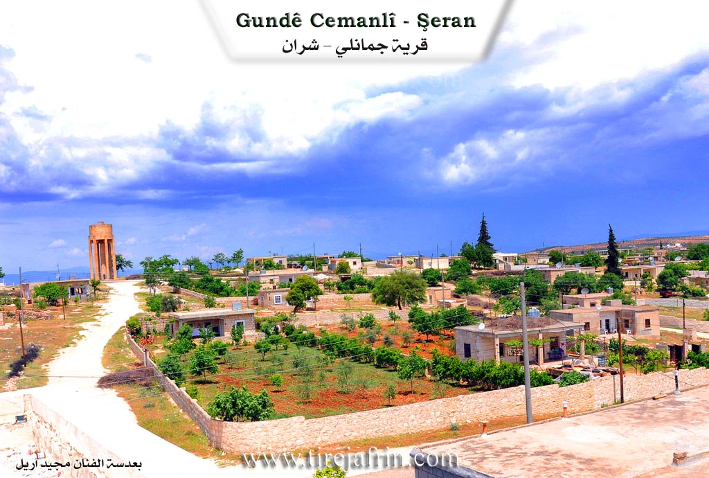
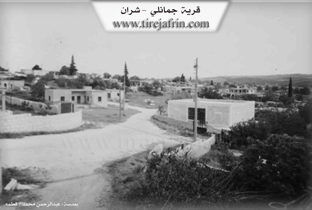
Photos
Basic Information about Çema
Source: Ax û Welat
Etymology: Named Çema meaning river or waters, derived from the abundance of water sources like Geliyê Sîmanê and its proximity to the Efrîn river
Foundation Date/Period: Pre-Islamic era
Springs: Kaniya Sîmon, Kaniya Keres
Shrines: Şêx Mihemed
Ruins: Xirabê Sîman, Xirabê Çartaqê, Naûs
Trees: Merxê
Wells: Bîreke polê
Other Landmarks: Geliyê Sîmanê, Çemê Efrînê, Çiyayê Parsê, Qestel Cindo
Summaries
I. Summary from TirejAfrin Site (English) of Çema
The following is stated in the book جبل الكرد (عفرين) دراسة جغرافية Çiyayê Kurmênc (Efrîn): A Geographical Study regarding Çema, Çemanlî, Ceman: 956 inhabitants, 428m elevation, 3km distance.
Regarding the name Çema: It is the name of a Kurdish tribe; some of them are found around Bitlis (Lerch, p. 49).
It is a medium sized village located atop a plateau whose western slopes descend steeply toward the valley of the Efrîn river. Pine forests are spread across the slopes surrounding it.
The book عفرين .... نهرها وروابيها الخضراء Efrîn... Her River and Her Green Hills states: Çemanlî is a village in Çiyayê Kurmênc belonging to the subdistrict of Şeran, district of Efrîn, governorate of Heleb (939 inhabitants). It is a large village situated on a limestone plateau with white clay soil, located 2km north of the town of Şeran. It is bordered to the north by a harsh and rugged slope, a plain planted with olive trees, the village of Elî Bazanlî, and Qarqîna Mezin at the bottom of the Efrîn river valley. To the south, there is a plain, a valley, a mountain chain, slopes, and the village of Senkerlî. To the east, there is a slope, a deep valley, the spring of Omranlî, a mountain chain, and the village of Omranlî. To the west, there is a mountainous slope planted with olive trees, forest trees, and vines, and the town of Şeran.
The number of its houses is approximately 125, and its age is about 350 years. Its old residences are made of stone and mud with wooden ceilings, while the modern ones are made of stone and cement, spread towards the east, west, and south. The village has an electricity network and drinking water provided by the state. It contains a primary school, a telephone center, and a mosque. Administratively, the village belongs to the municipality of Şeran.
Its residents work in the cultivation of olives and vines, and in raising sheep and goats. It connects to the subdistrict of Şeran via a paved road. In the western side of the village, the shrine of Şêx Mihemed is found. It is a beautiful and sweet village situated among olive trees from all directions, as well as fruit trees. Among its most important families is the family of Mihemed Reşîd.
Village Mukhtar: Enwer Mihemed
Sources of Information:
- Book: جبل الكرد (عفرين) دراسة جغرافية Çiyayê Kurmênc (Efrîn): A Geographical Study by د. محمد عبدو علي Dr. Mihemed Ebdo Elî.
- Book: عفرين .... نهرها وروابيها الخضراء Efrîn... Her River and Her Green Hills by عبدالرحمن محمد Ebdulrehman Mihemed from the village of Qetme.
- Studies of Navenda Tirej Soft / Ebdulrehman Hacî Osman.
- Some residents of the villages.
Preparation and Execution: Site Manager
- Tirej Efrîn: Ebdulrehman Hacî Osman 20/12/2013
II. Summary of Çema from Ax û Welat
Source: https://www.youtube.com/watch?v=SxDx9W2dsUw
The village of Çema, located in the Şera district of the Efrîn canton, is a settlement defined by its relationship with water and deep historical roots. The name Çema itself is derived from the word for "river," referencing the abundance of water sources in the area, particularly the Efrîn river to the west and the waters flowing from Geliyê Sîmanê. According to village elder Hec Qedrî, the history of the village is ancient, with origins lost to time, though narrators suggest the site may have been an inhabited city in the pre Islamic era.
The historical significance of Çema is visible in its ruins. The village contains rock cut structures known as Naûs. An expert, Abdullah, explains that these are not natural caves but hand carved tombs or dwellings, likely dating back to the Roman or Komagene period. He compares them to similar structures found near Dîlok and notes they feature architectural elements like arched burial niches. Other historical ruins around the village include Xirabê Sîman and Xirabê Çartaqê.
Socially, the village consists of several longstanding families. Hec Qedrî identifies Mala Elî Şêr (also referred to as Mala Elî Şan) as one of the first families. Other prominent lineages include Mala Îbê, Mala Misê, Mala Hemê, Mala Me'mê, Mala Ne'sê, Mala Ûsê, and Hespisîyo. The elder also recounts a migration event where three families—Mala Qelqê, Mala Hemîkê, and Mala Hûrê—left the village generations ago due to internal disputes.
Water was the center of community life. Residents like Fatme and Şaziye recall the days before modern plumbing when women from Çema and neighboring villages like Qerqîna and Ba'rava would gather at the spring in Geliyê Sîmanê. This was a social hub where they washed clothes, cleaned wheat, and shared meals under the shade of massive trees. One woman recounts a dramatic story from forty years ago when a flood at the spring was so powerful it swept away an ox (ga) belonging to her family.
The spiritual life of Çema revolves around the shrine of Şêx Mihemed, located on the high ground of the village. Villagers, particularly women, visit on Thursdays to light candles ("şem'a") and make vows. A woman at the shrine mentioned praying for her son who had been detained by Cebhet el Nesra. Historically, a large Merxê tree stood at the site, though it has since fallen. The villagers also practice a rain summoning ritual involving a figure or ladle called "dahen," where men and youths tour the village at night to request rain during droughts.
Culturally, Çema is renowned for a specific folk dance called Govenda Awî Reşko or Govenda Rişkû. The Muxtar explains that this dance is unique to their village and pantomimes agricultural tasks, such as killing fleas and winnowing wheat at the threshing floor, serving as a reminder of personal hygiene and hard work.
II. Summary of Çema from Khalil Sino
Source: https://www.youtube.com/watch?v=PR7sBnmtA-Y
The village of Çemo, which is also referred to as Çema or Çamo, is a
historic settlement located in the Şera district, approximately three
kilometers from the district center and twenty kilometers from the canton of
Efrîn. Situated among neighboring villages such as Sînka, Qerqîna,
Be'raş, and Omera, the village derives its name from the Kurdish word for
river or stream. The hosts explain that it was originally named Çemo due to
the abundance of flowing water and springs that once characterized the area.
While the exact foundation date remains unknown to the current generation,
elders recall a time when the original settlement consisted of merely five or
six households clustered around a large central spring.
Over time, the population of Çemo grew significantly. As agricultural families
expanded, residents began building new homes outside the original village
boundaries. Specifically, the Mamed and Nasir families were instrumental in
this demographic expansion, establishing new residential clusters that
eventually merged into larger interconnected communities comprising hundreds of
households. The documentary highlights the daily life of one such household, the
family of Îbisê Elî Hêwê, who is also known locally as Ebû Ekrem.
Historically, the village economy was heavily based on cultivating wheat,
barley, lentils, apples, and peaches. Today, agriculture remains central to
village life, though the focus has shifted predominantly to olive and fruit
orchards. The residents are noted for their collective spirit, which was clearly
demonstrated when the entire village contributed funds, gold, and physical labor
to build the local mosque. Furthermore, Çemo holds a distinct place in local
culture, having previously hosted the regional Newroz festival every two
years.
The physical landscape of Çemo is marked by ancient ruins, caves, and notable
geographical features. Significant archaeological landmarks include the ruins of
Xirab Sîman and Xirabî Şefaqê. Essential water sources like Kaniya Sîman
and the poetic Kaniya Lêlînê are deeply woven into the local geography and
folklore. Another famous natural landmark was a prominent tree known as [Dara
Lalê] located at the entrance of the village. Although it was cut down several
years ago, it remains a subject of local intrigue, with its name supposedly
referencing a mute individual who planted it. The village has also produced
several notable figures, including the late teacher Ednan Dilbirîn.
Culturally, Çemo is renowned for unique traditions preserved by its residents.
Village women are famous for a century old culinary practice of making a
seasonal spring soup using wild mountain thyme, cracked wheat, and buttermilk.
They also prepare Ekmeqaşî, a traditional dish with a Turkish name that has
been fully integrated into the local cuisine. In addition to food, the village
is the sole preserver of a specific traditional folk dance known as the Rişko.
This dance features playful and pantomime movements where participants mimic
daily chores like kneading dough, ensuring that the unique heritage of Çemo
continues to survive through generations.
II. Summary of Çema from Khalil Sino 2
Source: https://www.youtube.com/watch?v=Zmnc3VR32GY
The documentary episode from the program Hatim Ji Efrînê, supported by
Navenda Tulîn, features an interview with a ninety year old woman. The host
begins by comparing the setting to the village of Herûco before confirming
that they are currently documenting the village of Çema in the Afrin region.
The host and a guest named Hêv sit with the elderly woman to record her life,
the history of the settlement, and the rich oral traditions of the past.
The woman shares the settlement history of Çema. She notes that her own family
was the first to settle in the village. Following them, other families arrived
and established themselves, including the Mesro family, the Hemoloro family,
and the Hesento family. Later on, the family of Mehmûd Reşîd and the
household of Wahîd Axa also relocated to the village. The surrounding lands
featured expansive olive groves, and she recalls her father owning one thousand
olive trees, which required the labor of twenty workers to maintain.
Religious and spiritual life was deeply intertwined with the local landscape.
The woman recounts that when they were young, their father would encourage them
to fast for seven days, promising them new holiday clothes in return. On the eve
of the holiday, the villagers would visit the local sacred shrine known as
Henên. The elders and the men would go into seclusion there, and the people
would draw holy water, which they referred to as the water of Zemzem, from the
well.
The conversation delves into the social structure and customs of the time. The
elderly woman emphasizes that the women of the past possessed greater wisdom and
endured significant hardships. She describes the grueling agricultural work in
the plains and mountains, where women would harvest wheat with sickles, gather
it into bundles, and transport it back to their homes. During these long days of
physical labor, the women would sing traditional work songs.
A significant portion of the interview highlights the rich oral history and
musical folklore of the area. The woman recites fragments of epic tales and folk
songs, mentioning figures such as Ebdê, Aîş, Seftah Beg, Xecê, Gulînê,
and the legendary Ahmedê Zerîfê. These songs reference distant cliffs and
locations like Zinarê Asî in Tirkiyê, Zinarê Obanê, Ezazê, Himse,
Cindrêsê, and Helebê, illustrating the broader social geography of the era.
She also recounts personal memories involving community members and relatives
such as her uncle Xwaro, Hesîn Abdula, and a man named Fêdil who came from
Ezazê. The interview references revered local singers and poets of the past,
specifically praising Cemîl Horo, Hesnocî, and Ehmetliq for their
unmatched vocal talents. The elderly woman reflects on courtship, the strict
modesty of the era, and traditional wedding practices where brides would be
transported on horses or mules. Her memories serve as a vivid testament to the
enduring cultural heritage of Çema and its people.
II. Ax û Walat Book 1
THE VILLAGE OF ÇEMA
10.3.2016
The village of Çema is affiliated with the Şera district of the Efrînê canton, located about 2 km from the town of Şera and 20 km north of the city of Efrînê.
The name of the village Çema comes from the area's richness in water and streams. There is also another village with the same name in Northern Kurdistan near Diyarbekrê, and it is said that the residents of both villages are related. The site of the village is ancient, and there are many caves in it. It is estimated that people lived in those caves in ancient times.
160
About 200 houses and nearly 2000 people live in the village. The Elîşan family was the first family to settle in the village of Çema, and later 3 families emerged from it; the family of Îbê, Misir, and the family of Hemê, and all three families are in the village. Along with these families, many other families came and settled here, such as:
The family of Hesîb, Ne’ê Eşûtê, Hesen, Ûsê, and the family of Hec Şerîf.
There are 2 martyrs from the village who were martyred in the Kurdistan Revolution, and their names are: (Kawa and Ekîn). The village commune has also been named Ş. Kawa.
The villagers make their living from agriculture, from olive groves and vegetable gardens with gourds, okra, tomatoes, pumpkins, and fruit trees like apricots, almonds, pomegranates, apples, and peaches. They sell their products in the markets of Efrînê and also plant fields of wheat, barley, lentils, chickpeas, and fenugreek. Along with agriculture, some families own livestock like sheep and goats and make a living for their families by selling their products.
After the Rojava Revolution, 4 sewing workshops were opened in the village, and about 100 people work there, making a living. This has allowed settlement and stability to occur in the village, and job opportunities have opened up for the young men and women of the village.
161
To the west of the village is the Efrînê River, which has been turned into a lake behind the Meydankê Dam, located 2 km south of the village. To the north of the village are the Sîmon spring and the Kerkez spring; villagers irrigate their gardens from them. Also to the south is Xirab Sîmon – it is an ancient cave that was used as a human dwelling. It is said that the site of the village was an ancient city, and this was in the pre-Islamic eras.
To the east of the village is (Bîrê Polê), and it is a very ancient water well. Under it, there is a water channel whose water comes from the (Parsê) mountain of (Qestel Cindo). On that channel, there are 3 other water wells – some time ago, the water of those wells was pumped into a water reservoir, and drinking water was distributed to many villages, such as: Gabeleka, Omera, Be’rava, and Qerqîna.
To the east of the village are the (Baflon) and (Şifaqê) mountains, planted with olive trees, and there are also forests of pine trees that were planted by the state.
To the south of the village are the villages of Sînka and Şera. To the north is the village of Omera, and to the west is the (Kurtê Bîrka) well.
A shrine named (Şêx Mihemed) is known to be at the top of the village. The people of the village visit it on Friday evenings and light candles. They also pray to God for their wishes and hopes to be fulfilled. Now
162
the area around the shrine has become the village cemetery. On the mornings of festival days, the people of the village visit this shrine again.
There are about 20 caves in the village. There is a cave that, through secret paths under the ground, reaches the Çawîş cave in the village of (Be’rava).
The water pump station that used to supply 5 villages with water is at the top of the village, but now it is only used for the village of Çema. There is a primary school where the village children study up to the 6th grade, and there is a mosque in the middle of the village where the villagers perform their prayers.
There are 2 olive presses in the village for pressing the villagers' olives.
Because the village is large, there are shops for all kinds of goods in the village, and the villagers get their necessities from them.
Transcriptions and Subtitles
| Source | Video | Subtitles | Transcript |
|---|---|---|---|
| Ax û Welat 1 | Watch Video | Download SRT | View Transcript |
| Khalil Sino 1 | Watch Video | Download SRT | View Transcript |
| Khalil Sino 2 | Watch Video | Download SRT | View Transcript |
Possible Village Name Meaning of Çema
"Čema" is the name of a Kurdish tribe.
Source: TirejAfrin Site
V. Links
- Tirej Afrin:
https://www.tirejafrin.com/site/kura%20afrin%20%20sheran%20-%20cema.htm - Ax û Welat:
https://www.youtube.com/watch?v=Lhxtufr9xfQ - Video:
https://www.youtube.com/watch?v=dSy4L4MpWWU - Link:
https://www.youtube.com/watch?v=Rn2Wic-UdN4 - Ax û Welat:
https://www.youtube.com/watch?v=SxDx9W2dsUw - Khalil Sino:
https://www.youtube.com/watch?v=PR7sBnmtA-Y - Khalil Sino:
https://www.youtube.com/watch?v=Zmnc3VR32GY