General Information
Nahiya (Subdistrict)
Cindires
Also Known As
Al-Hammam, Hemamê, Omar Agha Qashla, الحمام, Ḧemamê
Tribes
Golkê
Families, Clans, etc.
Arif Axa, Aze, Ağler, Birekê Axa, Biş, Ebdîn Axa, Ehmed Axa, Ehmed Kenc Axa, Enwer Axa, Genc, Izzet Axa, Kenc, Krêt, Malbata Arif Axa, Malbata Ebdo Reşo, Malbata Ehmed Axa, Malbata Ehmedê Biş, Malbata Elî Krêt, Malbata Enwer Axa, Malbata Izzet Axa, Malbata Mehmed Gênc, Malbata Nûrî Azê, Malbata Omer Axa, Malbata Silêman Axa, Malbata Şêx Mihemed Axa, Omer Axa, Roşo, Silêman Axa, Şêx Mihemed Axa

Photos
Basic Information about Ĥemamê
Source: Ax û Welat
Etymology: (The Bath) due to natural thermal sulfur springs used for healing found in the area.
Old Names: Qişla Omer Axa
Foundation Date/Period: Historical presence dating to Ayyubid era (inscription of Melik el-Eşref)
Springs: Hemam, Kaniya Reş
Ruins: Qişla Omer Axa, Qişla Arif Axa, Qişla Ehmed Axa, Mexfera Kevin
Wells: Bîra Xatûnê, Bîra Firfirkê
Other Landmarks: Deşta Hemqê
Summaries
I. Summary from TirejAfrin Site (English) of Ĥemamê
Source: https://www.tirejafrin.com/site/kura%20afrin%20Cindires%20-%20hemame.htm
It is stated in the book جبل الكرد (عفرين) دراسة جغرافية Çiyayê Kurmênc (Efrîn): A Geographical Study by د. محمد عبدو علي Dr. Mihemed Ebdo Elî:
Hemam /3088 inhabitants - 588 - 8km - 170m/:
It took its name from the mineral water baths (hemam) that were located near it.
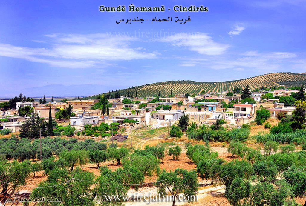
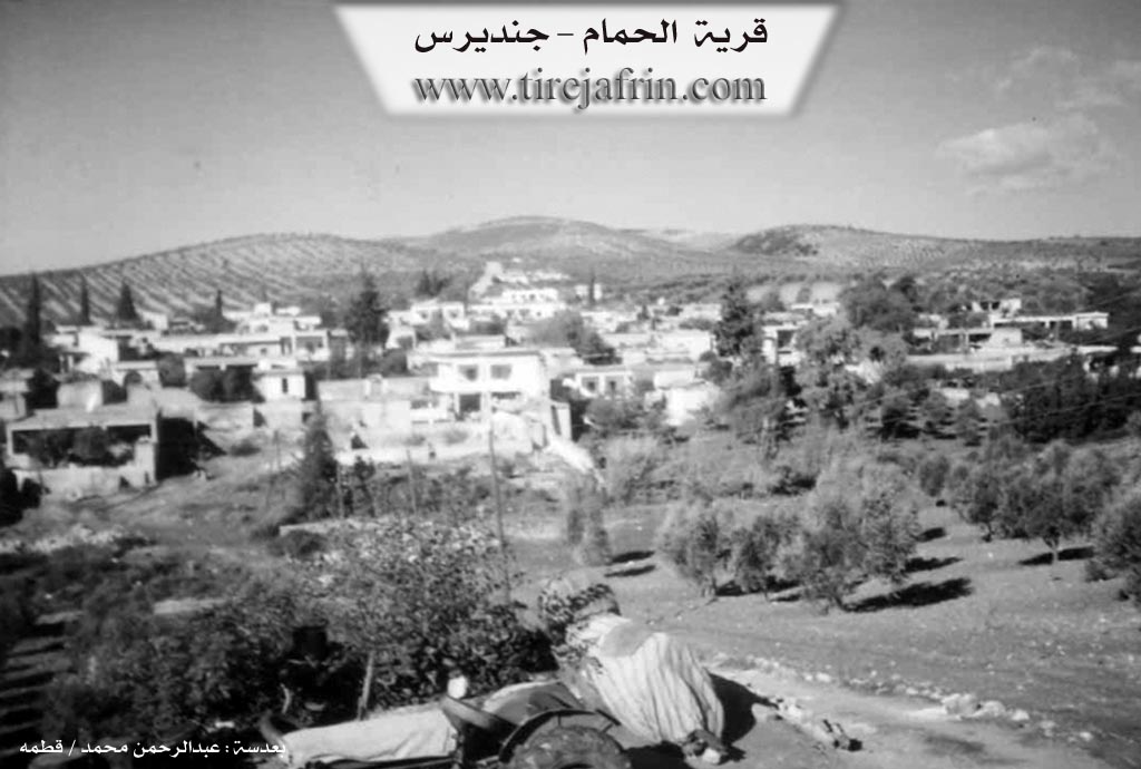
It is a large village located at the extreme southwestern end of the Efrîn region. It overlooks Deşta Amiq (Amik Plain) from the west. It contains an old palace belonging to the Aghas of the region from the Kenc family. The village was a major border crossing station before the cancellation of the border crossing that used to pass through it. During the border demarcation, the village was divided into two halves; the Turks moved their section far from the border line, while the border line and the paved road pass beside the Syrian village. One of the village residents dug an artesian well north of the village and built a restaurant, a swimming pool, and baths, exploiting the warm mineral water of the well.
It is stated in the book عفرين .... نهرها وروابيها الخضراء Efrîn... Her River and Her Green Hills by the writer عبدالرحمن محمد Ebdulrehman Mihemed from the village of Qetme:
Omer Axa Qişle / Hemam:
A village in Çiyayê Kurmênc, administratively belonging to the Cindirês district of the Efrîn region, Aleppo governorate. It is located at the southwestern end of the mentioned mountain, overlooking Deşta Amiq to the west and adjacent to the Sanjak of Alexandretta (Hatay) on the road leading to it. It is 8km west of the town of Cindirês.
It is bordered to the north, east, and south by the Turkish border (specifically: north by a valley and mountainous heights planted with olive trees, forest trees, the healing water baths, the village of Merwanê Jorîn, and a valley where olive trees rise, with the Turkish border directly 10 meters away). To the west, it is bordered directly by the Turkish border at a distance of 2 meters, the Turkish Deşta Amiq, and the town of Reyhanli. To the east, it is bordered by a valley, heights planted with olive trees, the village of Hecî Skender, and Eşkanê Rojava.
The number of its houses is about 150, and its age is approximately 500 years. Its old houses are made of mud and wood, while the modern ones are cement, extending north and east along the road that connects it to the town of Cindirês. Previously, during the French Mandate era, it was the center of the district (Nahiyah) before the annexation of the Sanjak of Alexandretta to Turkey. The center was then moved to Cindirês after independence in 1950 AD. It became a small village after that, but today the village of Hemam is a large village, extending north and east.
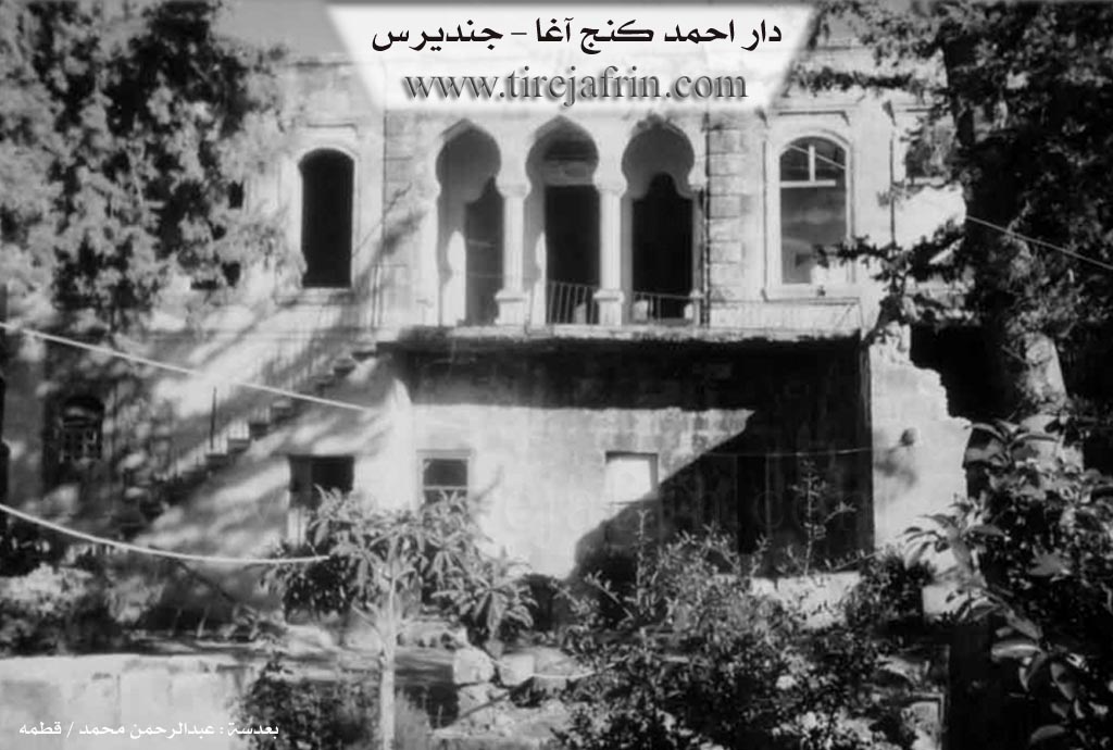
There are three old houses on the western side, 15 meters away, belonging to the family of Ehmed Kenc Axa. There is an old mosque inside the courtyard of one of the old houses built by the Ehmed Kenc Axa family; the house is currently destroyed and demolished, and a poor family lives in the ground section. The village has an electricity network, drinking water from artesian wells, a police station, and it is a border point. It contains a modern primary and preparatory school, a farmers' association, and a tourist restaurant containing healing waters in the northern section of the village called (Hemamên Şifa). It connects to the district and the region via a paved road.
Its residents work in the cultivation of olives, grains, and legumes, as trees cover 70% of the planted areas, irrigated by pumping from the village springs. They also produce summer vegetables. The people work in raising sheep and goats. The village drinks from an old well south of the village and from spring waters. It is connected to the town of Cindirês by a paved road. It is the last village on the southwestern side of the Efrîn region, Aleppo governorate, and Syria.
Among its most important families is the (Kenc Axa) family, of whom only one house remains; the rest of their lands remained on the opposite side of the border with Turkish territory. This village is considered one of the beautiful villages in the Cindirês district and the Efrîn region.
Village Mukhtar: Husên Reşîd Kinde
Sources:
- Book: جبل الكرد (عفرين) دراسة جغرافية Çiyayê Kurmênc (Efrîn): A Geographical Study by د. محمد عبدو علي Dr. Mihemed Ebdo Elî.
- Book: عفرين .... نهرها وروابيها الخضراء Efrîn... Her River and Her Green Hills by عبدالرحمن محمد Ebdulrehman Mihemed from the village of Qetme.
Preparation and Execution:
- Manager of Navenda Tirej Efrîn: Ebdulrehman Hacî Osman
- 20/12/2013
II. Summary of Ĥemamê from Ax û Welat
Source: https://www.youtube.com/watch?v=uabMKQ9hDoI
The village of Hemamê, located approximately 10 kilometers west of Cindirêsê in the Afrin region, is a settlement defined by its healing waters and the geopolitical division of the 20th century. Historically known as Qişla Omer Axa, the village was established as a local center of power by the Ağler (Aghas), a landed elite family who migrated from Mabetê. The settlement was divided among three brothers: Şêx Mihemed Axa, Arif Axa, and Silêman Axa. During the French Mandate era, the village served as a bustling trade hub (nahiye) with a bazaar that operated four days a week, attracting merchants from Heleb, Hama, and Hums.
The history of Hemamê was irrevocably changed in 1939 when the border between Syria and Turkey was drawn directly through the community. This division split the village in two; the northern section, known as Hemamê Ereba, fell under Turkish control, while the southern section remained in the Afrin region. This separation severed families and cut the villagers off from their agricultural lands and the original thermal springs located on the northern side. Despite this, the residents maintained a distinct identity, and in 1997, a new well was drilled on the southern side, successfully tapping into the same sulfur-rich thermal water source. This site is now a local center for treating rheumatism and skin ailments.
Architecturally, the village preserves traces of its feudal and administrative past. Notable structures include the ruins of the Agha mansions, such as the Qişla Arif Axa and Qişla Ehmed Axa. A former French military outpost, the Mexfera Kevin, still stands and is currently inhabited by locals like Nûrî Azê. The village mosque houses a significant historical artifact: a stone inscription bearing the name of the Ayyubid ruler Melik el-Eşref, suggesting a deep historical footprint in the area long before the modern settlement.
Water remains the lifeblood of Hemamê. Beyond the thermal spring, the village relies on historic wells such as Bîra Xatûnê and Bîra Firfirkê. Bîra Firfirkê was historically significant for its mechanism that pumped water to a reservoir supplying the surrounding houses and the gendarmerie. Today, situated on the edge of the Deşta Hemqê.
II. Summary of Ĥemamê from Ax û Welat 2
Source: https://www.youtube.com/watch?v=XT3afwYkNmY
The village of Hemamê, situated in the Cindirêsê district of Efrîn, holds a distinct place in the history of the region due to its curative thermal waters and its strategic location on the border. Historically, the settlement was known as Qişla Omer Axa. According to local elders, there was no village at the site originally, only a barracks. The settlement was founded in the early 20th century by the Omer Axa family, who belonged to the Golkê tribe. Three brothers named Şêx Mihemed Axa, Arif Axa, and Silêman Axa migrated from Mabeta and divided the land among themselves, establishing the current village structure.
The village is most renowned for its hot springs, which gave the place its name. For decades, these waters served as a major regional health destination. Visitors traveled from Heleb, Idlib, Hemê, and Hums to bathe in the sulfurous water, which was believed to cure rheumatism and various skin diseases. In the past, the village hosted two specific bathhouses. One was open to the public without charge, while the other was a paid facility rented out by the municipality to individuals such as Elî Krêt. This area was also a vibrant commercial hub, hosting a large weekly market that extended all the way to Kaniya Reş.
A defining moment in the history of Hemamê occurred in 1939 when the border between Syria and Turkey was formalized. This division split the community in two. The northern part of the settlement became known as Hemamê Ereba and fell under Turkish jurisdiction, while the southern part remained in Efrîn. This political separation cut the villagers off from the original thermal source. In response, residents on the Efrîn side dug new wells, such as Bîra Xatûnê and Bîra Firfirkê, to access the same underground thermal water for healing and agriculture.
Culturally and architecturally, the village preserves traces of significant historical layers. The local mosque houses an ancient stone inscribed with the name of Melik el-Eşref, an Ayyubid ruler. Elders recall that before the construction of a modern minaret, the religious leader would climb onto this large stone to recite the call to prayer. The village also witnessed various military presences, from the French Mandate forces to British and German troops during the war years. Despite the fragmentation caused by the border and the agrarian reforms that later redistributed the land of the aghas, the descendants of families like Enwer Axa and Izzet Axa maintain their connection to the history of Hemamê.
Transcriptions and Subtitles
| Source | Video | Subtitles | Transcript |
|---|---|---|---|
| Ax û Welat 1 | Watch Video | Download SRT | View Transcript |
| Ax û Welat 2 | Watch Video | Download SRT | View Transcript |
Foundation/Origin Information of Ĥemamê
The Kunj Agha family is one of its most important families.
Source: TirejAfrin Site
The village was founded by three Agha brothers—Şêx Mihemed, Erfan, and Silêman—on previously uninhabited land. It grew into a hub with a diverse population including Armenians, Assyrians, and Turks. In 1939, the Syria-Turkey border was drawn through it, splitting the community.
Source: Ax û Walat Transcript
The village was founded by three Agha brothers—Şêx Mihemed, Erfan, and Silêman—on a previously uninhabited area. During the French Mandate, it was an administrative and commercial hub with a notable Qurbet (Gypsy) community whose women are said to have dug a local well.
Source: Ax û Walat Transcript
Possible Village Name Meaning of Ĥemamê
It took its name from the mineral water baths that existed near it.
Source: TirejAfrin Site
Originally known as Qişla Omer Axa. The name Hamamê derives from its famous medicinal hot spring.
Source: Ax û Walat Transcript
Historically known as Qişla Emer Axa. The name Hemamê, meaning "the bath," derives from a natural medicinal hot spring.
Source: Ax û Walat Transcript