General Information
Nahiya (Subdistrict)
Reco
Also Known As
Al-Shuyukh, Sheikhlar Oba Si, Şêx, الشيوخ, شيخلر اوبه سي, شيخلراوباسي
Tribes
Wasilan, Şêxan, Şêxler
Families, Clans, etc.
Mala Ebdî Seydo, Mala Kolê, Mala Memî Eçmê, Mala Salihê, Mala Zilfê, Mala Êhû, Mala Şêx Ebdî, Mala Şêx Ehmed, Mala Şêx Hemû, Mala Şêx Menan, Şêx Ehmo, Şêxler
Photos
Basic Information about Şêx - Mt Hawar
Source: Afrin 366
Ruins: Qope
Other Landmarks: Gundê Xelîlo, Gundê Dîkê, Gundê Qesir, Gundê Qesim, Gundê Çê, Gundê Karrê, Ciyê bilbilê roy
Summaries
I. Summary from TirejAfrin Site (English) of Şêx - Mt Hawar
Source: https://www.tirejafrin.com/site/kura%20afrin%20%20%20Reco%20-shx.htm
It is stated in the book جبل الكرد (عفرين) دراسة جغرافية Çiyayê Kurmênc (Efrîn): A Geographical Study: Gu. Şx, Şêxler Obasi, The Sheikhs:
Şêx: A religious attribute for one of its early inhabitants.
Its location is west of the village of Eltaniya, and it is one of the deserted villages.
It is stated in the book عفرين .... نهرها وروابيها الخضراء Efrîn... Her River and Her Green Hills: Şêxler Obasi: A village in Çiyayê Kurmênc following the Reco sub-district, Efrîn area, Heleb governorate.
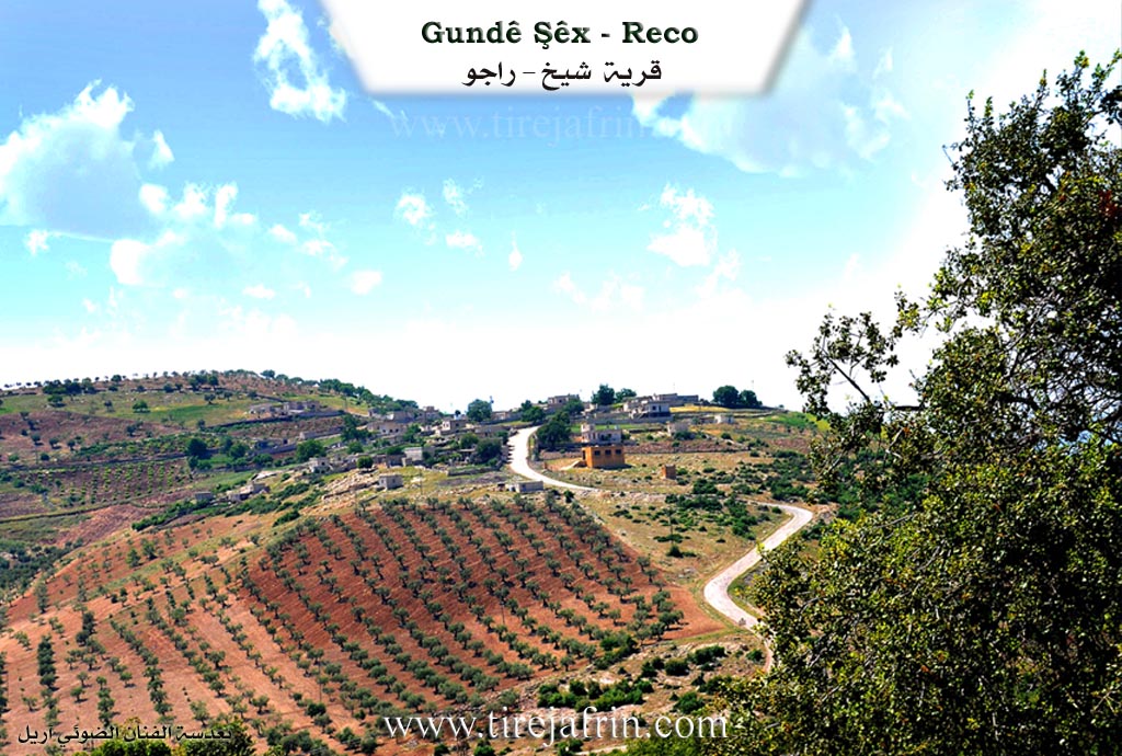
It is a small village located on a limestone plateau covered with oak forests. Its soil is clay-based and poor. It is located 17 km from the town of Reco towards the southeast. It is bordered on the north by a harsh slope, a deep valley planted with olive and walnut trees, and the village of Çetalkew; on the south by a mountain slope, a deep valley, and the village of Daxoba; on the east by a slope, a valley, and the village of Dîkoba; and on the west by a high mountain range planted with olive trees and the villages of Şêx Bilêl and Koliyan Jêrîn.
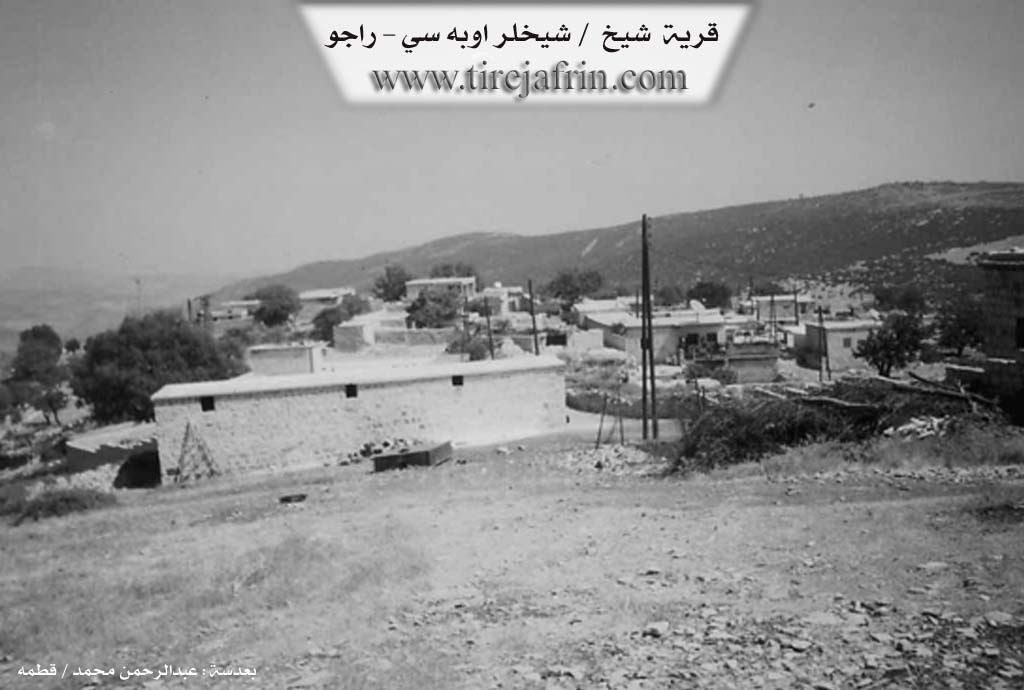
The number of its houses is 25, and its age is 250 years. The village consists of one family, according to the account of one of the residents. The origin of the inhabitants of this village is from the Kobanî area. They came from their region fleeing a problem that occurred with them during that period, so they inhabited this mountain height of the region and became the administrators of the village. Thus, the village was named after their family, Şêxler.
Its old dwellings are made of stone and mud with wooden ceilings, while the modern ones are cement and have spread eastward near the main road. An electricity network and a modern primary school are available. The village drinks from cisterns where rainwater is collected during the winter season. The people work in rain-fed agriculture on the slopes adjacent to the village (olives, vines) on an area of 111 hectares, alongside raising sheep and goats. It connects with the sub-district, the region, and neighboring villages via a paved road.
Among the families present in the village: The Şêx Ehmo family.
Among the social figures in the village: Şêx Şukrî Reşîd Ebdî and the teacher Mistefa Şêx Ehmed.
Village Mukhtar: Mihemed Şêx Mihemed.
Sources of Information:
- Book: جبل الكرد (عفرين) دراسة جغرافية Çiyayê Kurmênc (Efrîn): A Geographical Study by د. محمد عبدو علي Dr. Mihemed Ebdo Elî.
- Book: عفرين .... نهرها وروابيها الخضراء Efrîn... Her River and Her Green Hills by عبدالرحمن محمد Ebdulrehman Mihemed from the village of Qetme.
- Studies of Navenda Tirej Soft / Ebdulrehman Hacî Osman.
- Some residents of the villages.
Preparation and Execution: Site Manager Tirej Efrîn: Ebdulrehman Hacî Osman 20/12/2013
I. Summary from TirejAfrin Site (English) of Şêx
According to the book 'جبل الكرد' 'Mountain of the Kurds' (عفرين) geographical study:
Gu. Şêx (شيخلراوباسي), Al-Shuyukh (الشيوخ):
- Sheikh (شيخ): A religious title for one of its early inhabitants.
- Its location is west of 'Eltaniya village and it is one of the abandoned villages. [editor's note: This is almost certainly incorrect information as the "Gu. Şêx" on this page is clearly inhabited and east of 'Eltaniya. This is likely due to a conflation between a different "Gu. Şêx" in Reco and the one described here. Therefore, they may be more conflations in the data on this page.]
According to the book Afrin.... Its River and Green Hills:
Sheikhlar Oba Si (شيخلر اوبه سي): A village in Mount Kurdistan (جبل الكرد) belonging to Rajo subdistrict (ناحية راجو), Afrin region (منطقة عفرين), Aleppo governorate (محافظة حلب).
It is a small village located on a calcareous plateau covered with oak trees, with poor clay soil. It is located 17km southeast of Rajo town. It is bordered to the north by a rocky slope and deep valley planted with olive and walnut trees and Jatal Qowiyo village (جتال قويو), to the south by a mountain slope and deep valley and Tagh Oba Si village (طاغ أوبه سي), to the east by a slope and valley and Dayk Oba Si village (ديك أوبه سي), and to the west by a high mountain chain planted with olive trees and Sheikh Bilal and Koliyan Tahtani villages. The number of houses is 25 houses and its age is 250 years. The village consists of one family according to one resident's account, and the origin of this village's inhabitants is from the Ain al-Arab region who came from their region fleeing from a problem that occurred with them in that period, so they settled in this mountain elevation in the region and became Sufis in the village, so the village was named after their family Sheikhlar (شيخلر). Its old dwellings are clay and stone with wooden roofs, while the modern ones are cement spreading east near the main road. It has electricity network and a modern primary school. The village drinks from cisterns that collect rainwater during winter. The residents work in rain-fed agriculture on neighboring slopes (olives, vines) on an area of 111 hectares, alongside sheep and goat herding. It is connected to the subdistrict, region and neighboring villages by a paved road.
Among the families present in the village: Al Sheikh Ahmad (آل شيخ أحمو), and among the social figures in the village Sheikh Shukri Rashid Abdi (شيخ شكري رشيد عبدي) - Professor Mustafa Sheikh Ahmad (الأستاذ مصطفى شيخ أحمد).
Village mayor: Mohammed Sheikh Mohammed (محمد شيخ محمد)
Information sources:
1 - Book Mountain of the Kurds (Afrin) geographical study by Dr. Mohammed Abdo Ali.
2 - Book: Afrin.... Its River and Green Hills by writer Abdul Rahman Mohammed from Qatma village.
3 - Studies of Tirrej Software Center/Abdul Rahman Haji Othman (عبدالرحمن حاجي عثمان).
4 - Some village residents.
Prepared and implemented by: Director of Tirrej Afrin website: Abdul Rahman Haji Othman (عبدالرحمن حاجي عثمان)
20/12/2013
II. Summary of Şêx - Mt Hawar from Afrin Flo
Source: https://www.youtube.com/watch?v=ET8tCO1Mtnw
The documentary focuses on the history and heritage of Gundê Şêx, a village in the Efrîn region (specifically Çiyayê Kurmênc). The village was founded between 250 and 400 years ago, depending on the estimates provided by the elders Aref and the mukhtar Şêx Muhyedîn. The name Gundê Şêx derives from the lineage of its inhabitants, who are known as Şêxler. According to the elders, their ancestors migrated from Kobanê, specifically from a place called Doşlûk, and initially settled at a location referred to as kulbira Rabî.
The social structure of the village is defined by this single lineage. The residents identify as Şêxler and members of the Wasilan tribe. They are also identified religiously as Rifaî. The founding figures were two brothers, Şêx Hemû (or Şêxê Hemû) and Şêx Ehmed. Şêx Hemû was the first to arrive, followed by Şêx Ehmed. The current mukhtar, Şêx Muhyedîn, traces his direct lineage back to the founder: he is the son of Şêx Wisê, son of Şêx Ebdî, who was a descendant of Şêx Ehmed. Other historical figures mentioned in the village's genealogy include Şêx Seydî, Şêx Gulin, Mehmedê Zilfê, Nuhê Torî, Mihmedê Seydo, and Isto Zemîn.
A significant portion of the documentary explores the historic architecture of the village, specifically the Mala Şêx Menan (House of Sheikh Menan). This structure is estimated to be around 250 years old and features traditional stone arches (qenterme). The courtyard of Mala Şêx Menan contains a large, old tree that served as a central hub for the community's social life. Historically, villagers would fetch water from Gundê Kûzê and hang their water buckets (satil) on this tree. It was also the site for weddings, gatherings, and arbitration of disputes by the village elders. The house stands as a museum of sorts, preserving the agricultural and domestic tools of the past.
Today, Gundê Şêx consists of approximately 35 to 40 households. The local economy relies heavily on olive cultivation (zeytûn), which makes up about 80 to 90 percent of their livelihood, with some remaining livestock farming and agriculture. While connections with their relatives in Kobanê have been severed due to the conflict in Syria, the elders express a strong desire for Kurdish unity and the preservation of their history. The documentary concludes with a song by Şêx Nûh (also referred to as Nûhê Şêx Elî), a local elder and singer who recites lines mentioning Leyla Qasim and the geography of Kurdistan.
II. Summary of Şêx - Mt Hawar from Afrin 366
Source: https://www.youtube.com/watch?v=hMz0s5YzwKM
The documentary details a winter journey to the village of Gundê Şêx in the Racû district of the Efrîn region. The filming takes place during a period of heavy snowfall, with the host emphasizing the severe cold ("sar") and the difficulty of travel due to the snow ("berf"). The route to the village passes through a mountainous landscape defined by its proximity to several neighboring settlements, including Gundê Xelîlo, Gundê Dîkê, Gundê Qesir (also referred to as Gundê Qesim), and Gundê Çê. The host notes that the elevation of the area means Gundê Şêx often retains snow even when lower areas do not, and points out specific local landmarks such as Ciyê bilbilê roy.
Historically, Gundê Şêx is characterized as a small settlement. The host recalls that the village previously consisted of approximately thirty five households ("sî û pênc mal"). The transcript focuses on a visit to a specific ancestral home, identified as the house of Em Ehmed and Em Eyman. The host explores the "hewş" (courtyard) of this property, describing traditional architectural elements that remain standing, including the "hemam" (bath), "metbex" (kitchen), and "puxar" (chimney). Particular attention is given to a structure or ruin referred to as "Qope," which the host notes is still visible ("bes qope tenê").
The narrative is permeated by a sense of longing and displacement. Em Eyman, an elderly resident, discusses her long absence from the village, with the conversation reflecting on the scattering of the community ("milet çîna dinê"). The host observes that many houses are empty and that the residents are largely confined indoors due to the harsh weather and the broader situation in the region. Despite the melancholy of seeing empty homes ("kavil") and the intense cold, the speakers express deep affection for the village's nature and location. The documentation concludes with the team preparing to move on to the neighboring village of Gundê Karrê.
II. Summary of Şêx - Mt Hawar from Ax û Welat
Source: https://www.youtube.com/watch?v=13KJlWzk0_c
The documentary provides an in depth historical look at Gundê Şêx, a village located in the Raco district of the Afrin region. The village derives its name from the Şêxan tribe, specifically the Rîfaî branch of the Şêxan, to which all the villagers belong. It was founded approximately 300 years ago by Şêx Ehmed, a religious figure who migrated from the village of Taşlûk, also referred to as Daşlo, in the Kobanê region. Initially arriving alone, Şêx Ehmed spent a few years in the nearby village of Birnêş before marrying a woman from another village and deciding to establish his own settlement. He first built his home on a high ridge, but after a severe winter cold killed his chickens, he relocated a few hundred meters down into a sheltered hollow, which became the permanent site of Gundê Şêx.
Following his death, his son, also named Şêx Ehmed, expanded the lineage by having five sons whose descendants make up the present day families of the village. The primary families residing there today include Mala Ebdî Seydo, Mala Şêx Ehmed, Mala Zilfê, Mala Kolê, Mala Êhû, Mala Salihê, and Mala Memî Eçmê. Due to their shared ancestry, the villagers consider themselves one large family and maintain strong ties with their distant relatives back in the Kobanê villages of Daşlo and Mendikê. A village elder, Fethî, even compiled a comprehensive family tree starting from the original ancestors down to the newest born children to preserve their shared genealogy.
The villagers are deeply connected to their religious heritage. As descendants of a Şêx, they have historically held a highly respected position in the region, often serving as mediators to peacefully resolve disputes among surrounding communities. The village is well known for its Islamic practices, particularly the recitation of the Mewlûd and the performance of Zikir. These rituals traditionally took place on Thursday evenings and Fridays in the home of village elders, such as Şêx Ebdî, known as Şêx Ebdiyê Kole, and later Şêx Hisên. During the Zikir, participants invoke prominent religious figures such as Mihemed, Ebdil Qadir, Rîfaî, and Bedewî.
Geographically, the village is surrounded by notable natural landmarks. To the west lies Çiyayê Hawarê and the village of Çiyê, to the north are Çiyayê Tizbiyê, Qêsim, and Goliyan, and to the south is Çiyayê Dozelkê. The area is intersected by several valleys, including Geliyê Gerê to the south, Geliyê Dibirk to the southwest, and Geliyê Gura to the east. East of the village is a shrine named Sebêbiçûk, which locals visit to seek healing and the fulfillment of wishes.
Economically, the villagers rely heavily on agriculture, specifically olive cultivation and livestock herding, with lands extending into areas like Deşt, Êbraz, and Qitîş. They also forage for wild plants like kerdî, a toxic plant that locals, as well as nearby Arab and Armenian communities, detoxify by boiling it with sumac to consume for its medicinal properties. Additionally, the village preserves traditional pastimes, reviving old games such as cûtî kûsî and feq û rovî, ensuring their cultural heritage endures for future generations.
II. Ax û Walat Book 1
VILLAGE OF ŞÊX
21.2.2016
The village of Şêx is affiliated with the Reco district of the Efrîn canton, located about 15 km east of the town of Reco and 30 km north of the city of Efrîn.
In the meaning of the name of the village (Şêx), it appears that there are religious people or sheikhs in it. Therefore, this village is known for this characteristic, meaning the traditions of the sheikhs and the affairs of the Islamic religion, such as reading the mawlid, dhikr, and religious rituals.
The name of the village comes from the name of the (Şêxan) tribe, and the inhabitants of the village are from the Wasilî branch, which is a branch of the (Rifa’î) of the Şêxan. It is said that for an unknown reason, a person named Şêx Ehmed from the village of Daşlûkê in the Kobanê region came and initially settled in the village of Dîkê, but after getting married, he built a house in a place called (Serî Gazê). Later, this place became a village known by the name of Şêx.
It is worth mentioning that the family of Şêx Ehmed is known as the Şêxler, and to this day they have not abandoned the traditions of their forefathers and continue to practice them. Weekly, the men of the village perform dhikr, and they also bury their dead with religious ceremonies.
To this day, the relations of the people of the village with their relatives in Kobanê in the villages of (Daşlûk and Mendikê) continue, and there is always coming and going between them.
There are 8 families in the village, and the foundation of all the families is one, they are:
Êho, Kalê, Evdê Seydê, Şêxê, Me’mî Êhmê, Salhê, Zilfê and the family of Şêx Ehmed.
The village of Şêx is a small village and has not grown, so there are only about 40 houses and nearly 300 people living in the village.
The villagers make their living from agriculture, and the cultivation and care of olive trees are the main products. They also plant fruit trees such as apricots, cherries, almonds, vineyards, and walnuts.
Along with agriculture, some people of the village also own livestock such as goats and sheep, and they sell their products in the markets of Reco and Efrîn.
To the east of the village are Mount Hawarê and the village of Çiyê. To the north are Mount Tizbiyê, the villages of Qêsim and Goliya, and to the south is Mount Duzelkê.
The village of Şêx is famous for its valleys and ravines; there are many valleys and ravines around the village:
Geliyê Gerê is to the south of the village, Geliyê Dibrik is to the southwest, and Geliyê Gura is to the east.
There is a shrine named (Se’bê Biçûk) to the east of the village. The people of the village visit that shrine for illness and the fulfillment of wishes.
The villagers dig around their trees, fertilize, and plant at the end of winter and the beginning of spring.
There is a primary school in the village where the children of the village study up to the 6th grade.
There is an old olive press in the village, but it is now in ruins. It is said that the oil that came from that press was better than that of the new presses.
It is worth mentioning that the foundation of all the sheikhs living in the Efrîn region is from Kobanê.
Many people in this small village have studied and continued their studies in cities and towns, because the people of the village love education very much; they see their salvation and that of their people in it. Therefore, nearly 50 men and women from the village have graduated from university in various fields, and along with that, many people have also completed institute and high school studies.
Transcriptions and Subtitles
| Source | Video | Subtitles | Transcript |
|---|---|---|---|
| Afrin 366 1 | Watch Video | Download SRT | View Transcript |
| Afrin Flo 1 | Watch Video | Download SRT | View Transcript |
| Ax û Welat 1 | Watch Video | Download SRT | View Transcript |
Foundation/Origin Information of Şêx - Mt Hawar
The village consists of one family according to one resident's account, and the origin of this village's inhabitants is from the Ain al-Arab region who came from their region fleeing from a problem that occurred with them in that period, so they settled in this mountain elevation in the region and became Sufis in the village.
Source: TirejAfrin Site
Founded by members of the Waslan tribe who migrated from the Kobanî region. The first settler is remembered as Şêx Ehmo, and the village's ancient cemetery is named in his honor.
Source: Afrin Flo Transcript
Possible Village Name Meaning of Şêx - Mt Hawar
Sheikh is a religious title for one of its early inhabitants. The village was named after their family Sheikhlar.
Source: TirejAfrin Site
Originally known as Doşlikê, the settlement was renamed Gundê Şêx (Village of the Sheikhs) to reflect the identity of its founders.
Source: Afrin Flo Transcript