General Information
Nahiya (Subdistrict)
Bilbilê
Also Known As
Bêlê, Bîlan, Bîlan Koy, بيلان, بيلان كوي
Families, Clans, etc.
Ehmedî Mistê, Emrûk

Photos
Basic Information about Bêlê
Source: Tirej Afrin
Etymology: Bl: Meaning the elongated high place in Kurdish, which agrees with the village's location
Foundation Date/Period: 400 years
Summaries
I. Summary from TirejAfrin Site (English) of Bêlê
Source: https://www.tirejafrin.com/site/kura%20afrin%20%20%20bilbile%20-%20bile.htm
Village Entry: Gund Bl Bêlan Köy Bêlan
It is stated in the book Çiyayê Kurmênc (Efrîn): A Geographical Study: Gund Bl, Bêlan Köy, Bêlan / 1483 inhabitants - 493 hectares - 11 km - 610 m /:
Etymology
Bl: Meaning the elongated high place in Kurdish, which agrees with the village's location.
Location and Geography
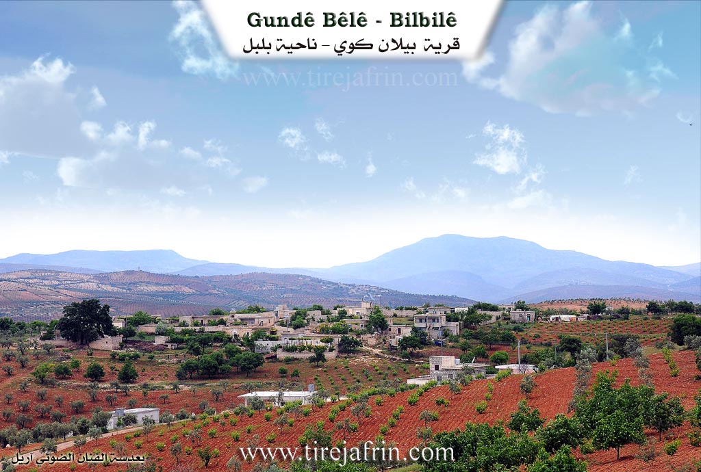
It is a small village located southeast of the town of Bilbile on the highest plateau in that district.
It is stated in the book Efrîn... Her River and Her Green Hills: Bêlan Köy is a village in Çiyayê Kurmênc following the Bilbile district, Efrîn region, Heleb governorate. It is a small village located southeast of the town of Bilbile at a distance of 12 km on the highest limestone plateau in the northern part of the Heleb plateau. It is covered by fertile soil. A torrential valley passes south of it, heading west to feed one of the large valleys descending from Çiyayê Heleb.
Boundaries
It is bordered to the north by a slope, a deep torrential valley, and the village of Kutanlî at the bottom of the depression. To the south, it is bordered by a slope, a torrential valley, a high mountain range planted with olive trees, and the village of Naza Uşaxî. To the west, it is bordered by a steep slope, the Riya Bilbile-Meydankê (Bilbile-Meydankê road), and the village of Qurê Kul. To the east, it is bordered by a slope, a mountain elevation, and the village of Qizilbaş, which is close by at a distance of 500 m.
Infrastructure and Housing
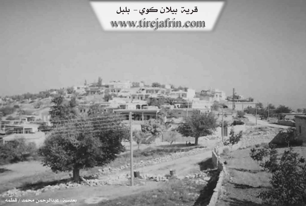
The number of its houses reaches about 50 houses, and its age is about 400 years. Its houses are of stone and mud with wooden ceilings, while the modern ones are cement, spreading towards the south around the public road. An electricity network and a primary school are available in it. The village drinks from cisterns in which rainwater is collected in winter, and currently from artesian wells dug next to the houses.
Economy and Agriculture
Residents cultivate grains, olives, and vines via rain-fed agriculture on an area of 493 hectares. A paved road connects it to the town of Bilbile, reaching the middle of the village.
Social Structure
Among its most important families is the Emrûk family, and they were the first to inhabit the village. The village is distinguished by its distinct high location and fresh air, overlooking what surrounds it.
Administration
Village Mukhtar: Ehmed Xelîl.
Sources
Book: جبل الكرد (عفرين) دراسة جغرافية Çiyayê Kurmênc (Efrîn): A Geographical Study by د. محمد عبدو علي Dr. Mihemed Ebdo Elî.
Book: عفرين .... نهرها وروابيها الخضراء Efrîn... Her River and Her Green Hills by عبدالرحمن محمد Ebdulrehman Mihemed from the village of Qetme.
Studies of Navenda Tirej Soft / Ebdulrehman Hacî Osman.
Some residents of the villages.
Preparation and execution: Manager of Tirej Efrîn site: Ebdulrehman Hacî Osman 20/12/2013
II. Summary of Bêlê from Afrin 366
Source: https://www.youtube.com/watch?v=-VMhWyJ_H6o
The documentary explores the picturesque village of Bêlê, sometimes referred to as Bêlo, situated in the Bilbilê subdistrict of the Efrîn region. The video was filmed at the special request of a local man named Îdrîs Osman, who currently resides away from the area. While touring the region, the host highlights the breathtaking natural environment, the lush gardens, and the traditional stone architecture that defines the settlement. The village is relatively large, comprising one hundred and three houses. However, like many rural communities, Bêlê has experienced substantial outmigration. Many younger residents have moved to urban centers such as Heleb, Cendêrêsê, and Stembolê, or have traveled abroad, leaving primarily elderly inhabitants to care for the homesteads and sustain the agricultural lifestyle.
During the visit, the host converses with an elderly woman resting outside her home. She identifies several neighboring villages visible from their vantage point, including Qizilbaş, Toliyê, and Ehmedî Mistê. The host originally assumed Ehmedî Mistê was simply a newly formed family lineage, but the woman clarifies that it is a distinct village named after a specific family. She explains that it is quite common in this region for settlements to adopt the names of their founding families. Another village, Qeregûl, is noted in the distance near a river.
The social fabric of the village is a major topic of discussion. An older man reflects on the historical agricultural practices of the community, specifically mentioning an old community well equipped with a traditional water lifting mechanism known as a dalîb. In the past, this well supplied drinking water for all the village livestock and served as a central gathering place. He expresses deep regret that modern technology has fractured their tight knit social community. He observes that smartphones, the internet, and social media platforms like Tîktok have isolated individuals. Instead of gathering for coffee and conversation as they did in the past, men, women, and children now sit silently absorbed in their screens.
The host also addresses practical challenges facing the residents, including poor road conditions and the severe risk of agricultural fires. During the hot and dry season, he issues a stern warning to farmers operating tractors and heavy machinery near dry vegetation, emphasizing that a single spark could destroy the collective livelihood of the village. The episode concludes with greetings to a young student named Mîran, the village mukhtar, and a local figure named Abu Îbrahîm, as the crew prepares to travel onward to document the neighboring villages of Qizilbaş and Ehmedî Mistê.
Transcriptions and Subtitles
| Source | Video | Subtitles | Transcript |
|---|---|---|---|
| Afrin 366 1 | Watch Video | Download SRT | View Transcript |
Foundation/Origin Information of Bêlê
Among its most important families is the Amruk family, who were the first to inhabit the village.
Source: TirejAfrin Site
Possible Village Name Meaning of Bêlê
Bêl: means the elongated elevation in Kurdish, which corresponds to the village's location.
Source: TirejAfrin Site