General Information
Nahiya (Subdistrict)
Şera
Also Known As
Bafilonê, Bafliun, Baflunê, Baflûnê, بافليون
Families, Clans, etc.
Evdê Seydo, Henan Evdo, Ibrahîm Elî Kûr, Malê Betê, Malê Dewrêş, Malê Ebdî Ûfê, Malê Hecî Husê, Îbrahîmê Elî Kûrê

Photos
Basic Information about Baflûnê
Source: Ax û Welat
Old Names: Xirabê Baflûnê
Foundation Date/Period: 150 to 200 years ago
Number of Caves: 15
Ruins: xirabê Baflûnê
Wells: Gulê Selmo
Summaries
I. Summary from TirejAfrin Site (English) of Baflûnê
Source: https://www.tirejafrin.com/site/kura%20afrin%20%20sheran%20-%20baflun.htm
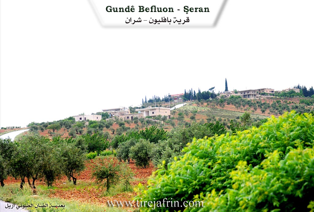
Based on the book Çiyayê Kurmênc (Efrîn) A Geographical Study: Baflûn / 602 inhabitants / 157 houses / 13 km distance / 770 m altitude.
It is believed that Baflûn is a Syriac name.
It is a small village situated in a fortified location. Its air is fresh due to the high elevation of its site, and it used to be a summer resort for some Aghas of the region. Near it are the remains of an English camp for oil exploration dating back to the fifth decade of the twentieth century. A road paved with stones leads to it from the east of Qetme, dating back to that period, and it is still in good condition.
According to the book Efrîn... Her River and Her Green Hills:
Baflûn is a village in Çiyayê Kurmênc following the Şera district of the Efrîn area in the Heleb governorate. It is a small village located in the eastern part of Çiyayê Kurmênc and the northern part of Çiyayê Seman on a high mountainous elevation and in a fortified defensive location.
It is bordered to the north by mountainous highlands planted with olive trees and vineyards, the remains of buildings from an English company from the 1940s, and the villages of Ceman, Omera, and Sînka. To the south, it is bordered by a stream and a slope heading southward, the lands of the village of Qetme, and the Xeta Trêna Heleb-Meydan Ekbez (Heleb-Meydan Ekbez railway line). To the west, there is a deep stream, mountainous highlands planted with olive trees and forest trees, and the village of Qetme. To the east, there is a slope, a stream, rugged mountainous highlands planted with olive trees and vineyards, the shrine of Şêx Hemîd, the village of Qestel Cindo, and the city of Ezaz.
The number of its houses is approximately 55, and its age is 103 years, meaning it was founded in the year 1903. Its old houses are made of stone and mud with flat wooden roofs, while the modern ones are concrete and spread to the south and west. The residents work in the cultivation of olives and grains alongside the raising of sheep and goats. An electricity network is available, as well as drinking water from an artesian well in the village of Malkiyê. It contains a primary school and a telephone connected to the Qetme telephone center. A newly paved road reaches the center of the village and connects to the village of Qetme and Qestel Cindo. Administratively, it belongs to the municipality of Qetme.
Among its most important families is the Ibrahîm Elî Kûr family, who were the first inhabitants of the village. The number of its souls, according to the civil registry on date 31/12/2004, is 593.
Village Mukhtar: Ebdo Sîdo Sîdo
Sources
Book: جبل الكرد ( عفرين ) دراسة جغرافية Çiyayê Kurmênc (Efrîn): A Geographical Study by د. محمد عبدو علي Dr. Mihemed Ebdo Elî.
Book: عفرين .... نهرها وروابيها الخضراء Efrîn... Her River and Her Green Hills by عبدالرحمن محمد Ebdulrehman Mihemed from the village of Qetme.
Studies of Navenda Tirej Soft / Ebdulrehman Hacî Osman.
Some residents of the villages.
Preparation and Execution: Manager of the Tirej Efrîn website: Ebdulrehman Hacî Osman 20/12/2013
II. Summary of Baflûnê from Ax û Welat
Source: https://www.youtube.com/watch?v=G2CbtBUzOWY
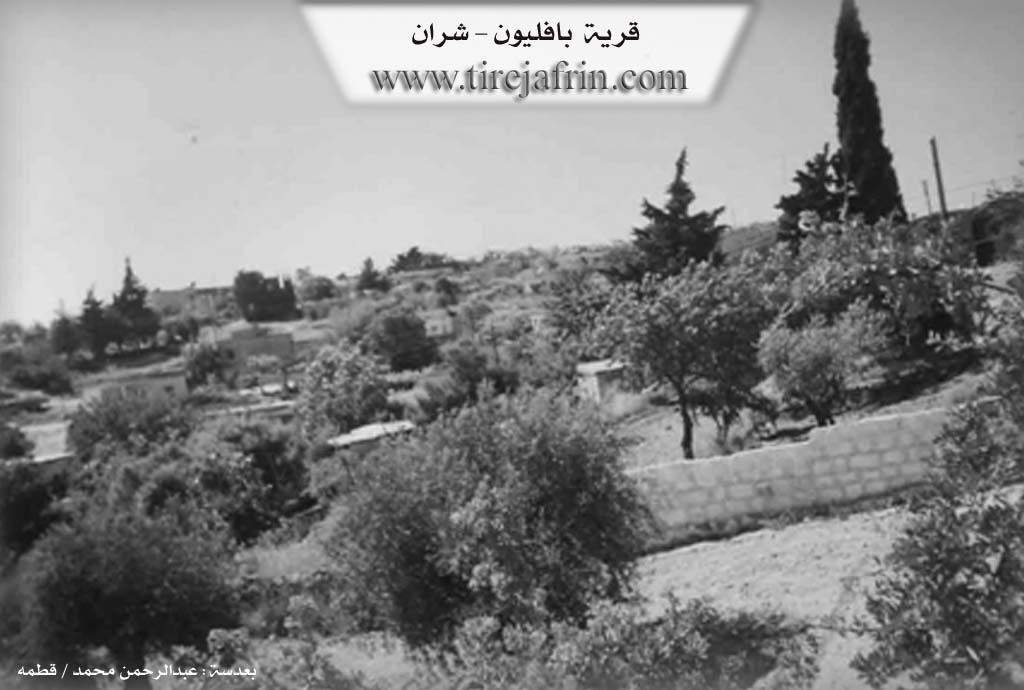
The village of Baflûnê, situated in the Şera district of Çiyayê Kurmênc, stands at an altitude of approximately 700 meters. The current settlement was founded between 150 and 200 years ago by two cousins named Ibrahîm and Henan. These founders migrated from the nearby village of Qitmê, located just five kilometers away. According to village elders, they sought refuge in this mountainous location to escape religious persecution and preserve their Êzdî faith. Prior to their arrival, the site was known as xirabê Baflûnê, indicating that it had been inhabited and subsequently ruined in earlier historical eras.
The population of Baflûnê is entirely Êzdî. Following the initial establishment by the lineages of Îbrahîmê Elî Kûrê and Henan Evdo (also identified as Evdê Seydo), the community expanded with the arrival of other families. These include Malê Hecî Husê, Malê Dewrêş, Malê Betê, and Malê Ebdî Ûfê. Elders note that some of these later groups arrived from Sînko. The village grew to contain approximately 70 to 80 households, with residents primarily engaging in agriculture and the cultivation of olive trees.
A distinctive feature of Baflûnê is the presence of numerous ancient caves and rock cut cisterns. Villagers estimate there are around 15 caves in the vicinity, with several located within the village itself. These caves played a crucial role in the survival of the community during times of instability. Residents describe a historical defense system where ropes connected the caves; if bandits or threats were detected, a rope would be pulled to ring bells inside neighboring caves, alerting the entire community to take defensive positions. One particular ancient cistern is named Gulê Selmo, honoring a local woman responsible for its maintenance.
The documentary focuses heavily on the preservation of Êzdî cultural traditions, specifically the celebration of Cejna Xidir Êlyas. A central custom discussed is the preparation of Pêxûn, a mixture of seven roasted and ground grains including wheat, barley, chickpeas, and lentils. This mixture is heavily salted and consumed by unmarried youth before they sleep. Tradition holds that they must not drink water after eating it; instead, they hope to dream of a person offering them water, whom they believe will be their future spouse. The program concludes with a villager singing the epic ballad of Derwêşê Evdî, further rooting the village in the oral history of the region.
Transcriptions and Subtitles
| Source | Video | Subtitles | Transcript |
|---|---|---|---|
| Ax û Welat 1 | Watch Video | Download SRT | View Transcript |
Foundation/Origin Information of Baflûnê
Among its most important families is the Ibrahim Ali Kor family, who are the first inhabitants of the village.
Source: TirejAfrin Site
According to oral tradition, the village was established by two cousins, Ibrahim and Hanan, who were shepherds from the village of Qitmê. They fled persecution from Islamic authorities and settled in the area, then known as Xerabê Baflunê (the Ruins of Baflunê), taking refuge in its ancient caves.
Source: Ax û Walat Transcript
Possible Village Name Meaning of Baflûnê
It is believed that "Baflun" is a Syriac name.
Source: TirejAfrin Site