General Information
Nahiya (Subdistrict)
Reco
Also Known As
Barbane, Barbenê, Berbend, Berbenê, بربند, بربنه
Tribes
Biyan
Families, Clans, etc.
Malê Xelîl Cinê

Photos
Basic Information about Berbenê
Source: Khalil Sino
Foundation Date/Period: Dewra Tirk
Springs: Kaniya Berbenê
Ruins: Hashewre, Qûrîk
Wells: Bîra Gêlê
Other Landmarks: Geliyê Tîra, Kithix, Gola
Summaries
I. Summary from TirejAfrin Site (English) of Berbenê
Source: https://www.tirejafrin.com/site/kura%20afrin%20%20%20Reco%20-%20Berbene.htm
It is stated in the book جبل الكرد (عفرين) دراسة جغرافية Çiyayê Kurmênc (Efrîn): A Geographical Study: Barbend / 1600 inhabitants, 8km distance, 500m altitude.
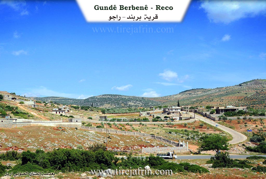
Barbend: The literal Kurdish meaning of the name is: beside the cliff (ber + bend). The village lies below a large rocky cliff that extends from the west toward the east.
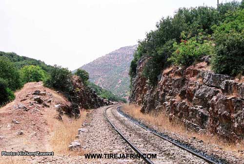
It is a medium sized village, located on the eastern side of the southern entrance to Geliyê Tîra (Arrow Valley). Its houses are spread across the southern slopes of Çiyayê Hawar. Passing by its western side is the Xeta Trêna Şerqê Bilez (Orient Express railway line) and the paved road.
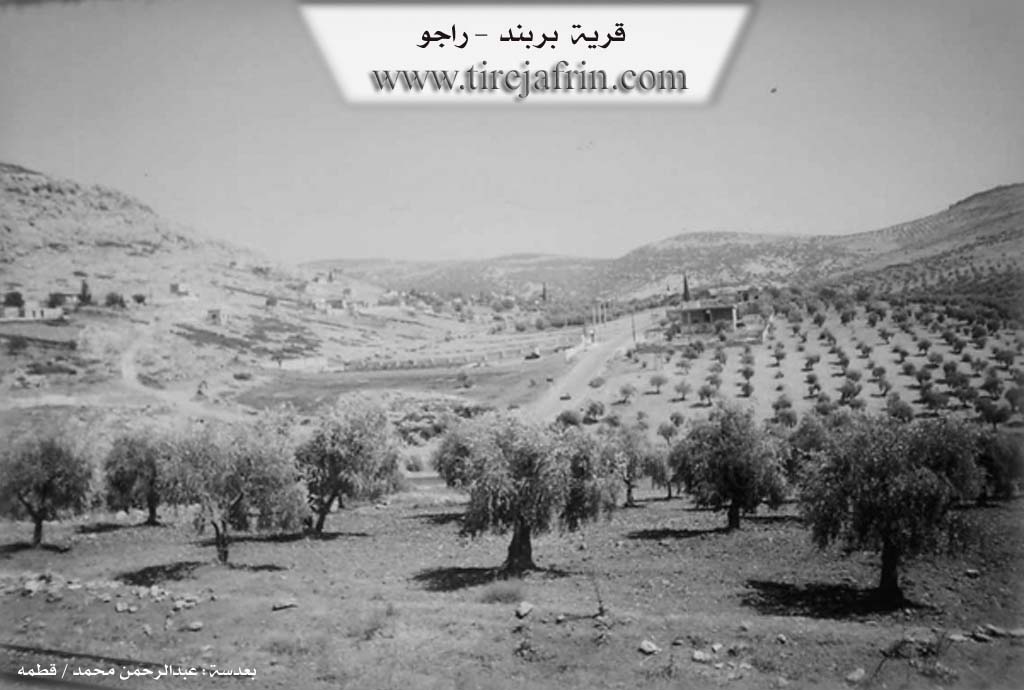
It is stated in the book عفرين .... نهرها وروابيها الخضراء Efrîn... Her River and Her Green Hills: Barbend is a village in Çiyayê Kurmênc following the Reco subdistrict, Efrîn region, Heleb province. It is a large village situated on a rocky flat at the end of the southern slope of a limestone height. It runs parallel to the Derbasa Reco (Reco pass) from the east and south along a valley bed heading toward the southwest in lands with clay soil. It is 9 km away from the town of Reco toward the southeast.
It is bordered to the north by a valley, a high mountain range, and the village of Goliya Jorîn; to the south by a valley, a very high and rugged mountain range, and the village of Oksizlî; to the east by a rugged mountain range and the village of Goliya Jêrîn; and to the west by a deep watercourse, Geliyê Tîra (Arrow Valley), the Riya Reco-Efrîn (Reco-Efrîn road), the Xeta Trêna Heleb-Meydan Ekbez (Heleb-Meydan Ekbez railway), and the village of Hemşilê.
The number of its houses reaches 80 houses, and its age is approximately 350 years. Its old residences are stone and mud with wooden roofs, while the modern ones are cement and have spread east and west. An electricity network is available, as is a paved road passing through its center reaching to the neighboring villages. The village drinks from cistern water that collects rainwater in winter, and currently, they have begun drilling artesian wells. There is a primary school in the village. The residents work in rain fed agriculture on an area of 69 hectares (olives, vines) in addition to fruit trees, alongside sheep and goat herding.
Village Mukhtar: Ibrahîm Xelîl.
Sources of Information:
- Book: جبل الكرد (عفرين) دراسة جغرافية Çiyayê Kurmênc (Efrîn): A Geographical Study by د. محمد عبدو علي Dr. Mihemed Ebdo Elî.
- Book: عفرين .... نهرها وروابيها الخضراء Efrîn... Her River and Her Green Hills by عبدالرحمن محمد Ebdulrehman Mihemed from the village of Qetme.
- Studies of Navenda Tirej Soft / Ebdulrehman Hacî Osman.
- Some residents of the villages.
Preparation and execution: Manager of the site Tirej Efrîn: Ebdulrehman Hacî Osman 20/12/2013
II. Summary of Berbenê from Khalil Sino
Source: https://www.youtube.com/watch?v=GS-fnQmz9c0
The village of Berbenê is located in the Afrin region, specifically in the area known as Çiyayê Kurmênc (Mountain of the Kurds), approximately 7.5 to 8 kilometers from the town of Reco. According to local elders, the village has a deep history dating back to the Dewra Tirk (Turkish/Ottoman era). Originally, the settlement pattern was different; seven villages existed in the highlands above the current location before the population descended to the present site.
The social structure of Berbenê is defined by the Biyan tribe, who are described by residents as Xanedan (noble or notable). The villagers trace their origins to an ancestral site called Hashewre. During their migration history, they gathered at a location called Qûrîk before establishing the current village. The community maintains close kinship ties with relatives in nearby villages, specifically Hurîtonê and the Malê Xelîl Cinê family in Heyêtê. Today, the village consists of approximately 100 to 120 households.
The geography of Berbenê is characterized by three famous landmarks: the spring Kaniya Berbenê, the valley Geliyê Tîra, and the ancient site of Hashewre. In the past, before modern infrastructure, residents fetched water from a well known as Bîra Gêlê or relied on hand-dug Sarnîc (cisterns), some of which are over a century old. Residents also recall washing clothes at a site simply called Gola (the lake). The village contains one primary school and one mosque but notably lacks a cemetery (Meqbes) and a marketplace. For commerce, residents travel to markets in Reco, Efrîn, or Ba'dîna.
Culturally, Berbenê preserves specific culinary traditions, including Kulik, Şûrba (specifically a spinach dish called boranî), and Hewîrê sor (a local variety of çîkofte). Elders such as Enwer (58), Fatme (77), and Zênalê Ehmedê Zênebê (also referred to as Ehmedê Xelîl Mehmê) recount a history of communal labor and strong social bonds. Fatme describes the hardships of the past, such as hauling wood from the mountains and harvesting olives (Pa'lo). Zênal emphasizes the decline of traditional trust (Sîqet) and shares parables about the values of "Love" (Hezkirin) versus "Wealth" (Rizq) and "Luck" (Şoms). The villagers maintain friendly relations with neighboring communities such as Ba'dîna, Xûpê, Gûliyo, and Sêviyo.
Transcriptions and Subtitles
| Source | Video | Subtitles | Transcript |
|---|---|---|---|
| Khalil Sino 1 | Watch Video | Download SRT | View Transcript |
Possible Village Name Meaning of Berbenê
The literal Kurdish meaning of the name is: beside the cliff.
Source: TirejAfrin Site
V. Links
- Tirej Afrin:
https://www.tirejafrin.com/site/kura%20afrin%20%20%20Reco%20-%20Berbene.htm - Video:
https://www.youtube.com/watch?v=lxT7YR5b72o (no longer available) - Link:
https://www.youtube.com/watch?v=AmqfrjhKlzM - Khalil Sino:
https://www.youtube.com/watch?v=GS-fnQmz9c0