General Information
Nahiya (Subdistrict)
Nubl
Also Known As
Al-Qaz, Birc Qaws, Erdê Hêşîn, Bircilqas, Bircilqazê, Birckê Terpê, Birckê Weqês, Bircqasê, Birj al-Qas, القاز, برج القاص, برج قاص, Birca Spî
Tribes
Menqurî, Şerqiyan, Şêrawa
Families, Clans, etc.
Elî, Hemo, Hemû, Hesen, Nasir, Naso, Nebûkê

Photos
Basic Information about Bircilqazê
Source: Ax û Welat
Etymology: Originally Birca Spî (White Tower); later Birc el-Qaws (Tower of Arches) due to eight arches, which evolved into Birc Qas; also known as Bircika Têrpê after the first settler Têrpê Kal
Old Names: Birca Spî, Xirabê Kîmarê
Foundation Date/Period: Ancient period (Hurrian/Roman era); Resettled in the modern era (approx. 19th century)
Number of Caves: 2
Hills: Çiyayê Lêlûn, Cebel Heswar
Shrines: Şêx Qesab, Nebî Qesab, Gulî Sor, Marmarûn, Kenîse Julyanos
Ruins: Xirabê Kîmarê, Barad, Kefer Nebû, Birc Heyder, Xirabê Şemsê
Wells: Rikî
Other Landmarks: Kefer Heşîr, Erdê Şîn, Sedê Şîn
Summaries
I. Summary from TirejAfrin Site (English) of Bircilqazê
Source: https://www.tirejafrin.com/site/kura%20afrin%20markaz-bircke%20qes.htm
The following is stated in the book جبل الكرد (عفرين) دراسة جغرافية Çiyayê Kurmênc (Efrîn): A Geographical Study by د. محمد عبدو علي Dr. Mihemed Ebdo Elî: Birck Weqs Birck Terp, Burj el-Qas, el-Qaz / 40km 530m /:
The name consists of the word: 'Birck' (tower), and from: 'Weqas', which is a Kurdish proper name. As for the second name of the village, 'Terp', it is a nickname for one of its early Kurdish residents, and the residents of the Şêrawa villages are known for the abundance of nicknames. As for X. El-Esedî, he says that the origin of the name "Burj el-Qas Burj el-Qiss" is from Burja Diqsha: Tower of the Sheikh, /El-Esedî, Vol 2, p. 85/.
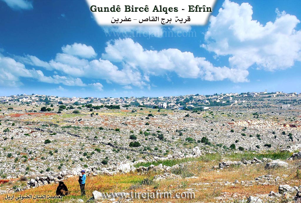
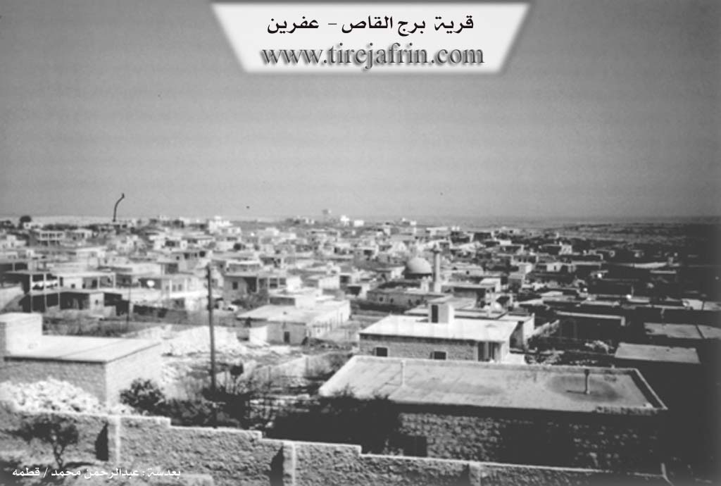
It is a small village, located within the rocky terrain of Çiyayê Lêlûn, and it is considered the furthest village in the administrative perimeter of the Efrîn region on its southeastern borders, and it is closer to Heleb than to Efrîn. In the village, there are traces of buildings and ancient architecture from the Greek eras. It is worth mentioning that this village was attached to the Nubl sub district in 1975.
The following is stated in the book: عفرين .... نهرها وروابيها الخضراء Efrîn... Her River and Her Green Hills by the writer عبدالرحمن محمد Ebdulrehman Mihemed from the village of Qetme:
Burj el-Qas: A village in Çiyayê Lêlûn, it follows the sub district of the villages of the Efrîn center and region, Heleb governorate. It is a large village located on the slopes of the central section of Çiyayê Lêlûn. It follows the villages of the Efrîn center sub district. It is bordered to the north by a rugged mountain chain of rocks and the village of Mayêsa; to the south by a slope and a valley planted with some pomegranate, almond, and olive trees and the village of Kalûte; as for the east, a rugged mountain chain and the town of Nubl; and to the west it is bordered by a high mountain chain of Çiyayê Lêlûn, a valley, and the village of Kefêr Nebo.
The number of its houses is 175 houses and the age of the village is about 400 years. Its residences are old, made of mud domes, and modern construction of stone and reinforced concrete has extended from all sides of the village. An electricity network is available, as well as drinking water from the well of Zûq el-Kebîr. The paved road reaches the middle of the village and the town of Nubl. It contains a primary school and a mosque located in the center of the village.
The habitation of the area is ancient, indicated by its old antiquities, including a tower in the western side of the village, archaeological columns, a tower in the western side of the village, and wells dug into the rocks dating back to the Roman and Byzantine eras. The residents of the village work in grain cultivation and the raising of sheep and cows. There are some green patches in the northern and southern sides at the spillway of the drilled artesian wells. It was administratively annexed to the Ezaz region since 1980 due to the creation of the Nubl sub district.
Preparation and Execution:
Manager of the Tirej Efrîn site: Ebdulrehman Hacî Osman
20/12/2013
Sources:
- Book: جبل الكرد (عفرين) دراسة جغرافية Çiyayê Kurmênc (Efrîn): A Geographical Study by د. محمد عبدو علي Dr. Mihemed Ebdo Elî.
- Book: عفرين .... نهرها وروابيها الخضراء Efrîn... Her River and Her Green Hills by عبدالرحمن محمد Ebdulrehman Mihemed from the village of Qetme.
II. Summary of Bircilqazê from Ax û Welat
Source: https://www.youtube.com/watch?v=1E3jCYi3i_0
The village of Birc Qas, locally known as Bircika Têrpê, is situated on Çiyayê Lêlûn within the Şêrawa district of Efrîn. The settlement sits amidst a landscape rich in ancient history, with roots tracing back to the Hûrîgîn civilization and the Roman era. The village name has undergone several evolutions. It was originally called Birca Spî due to a white watchtower that once stood there. Later, it was known as Birj el-Qaws because of eight distinctive arches found in the ruins, which eventually shortened to Birc Qas. The alternative name, Bircika Têrpê, honors Têrpê Kal, who is cited as the first individual to settle the modern village site.
According to oral history narrated by the elders, the location was previously a ruin known as Xirabê Kîmarê. A figure named Mensûrê Kal from gundê Mezin initiated the settlement, sending his son Xidir to establish a foundation. The current population is primarily composed of the Menqurî tribe, which is affiliated with the Şerqiyan confederation. The main families identified in the village include Hesen, Elî, Nasir, and Hemû, all of whom share common ancestry tracing back to settlers like Hemo and Naso from gundê Mezin.
The religious history of Birc Qas reflects a significant transition. Residents note that until roughly eighty years ago, the entire village adhered to the Êzdî faith before converting to becoming Misilman. One elderly resident, originally from Qitmê, remains the sole Êzdî in the village, preserving the memory of the older traditions. The community maintains a deep connection to sacred sites, particularly the shrine of Şêx Qesab, also referred to as Nebî Qesab or Gulî Sor. Located in a cave south of the village, this site is visited on Wednesdays by Êzdî devotees and Thursdays by Misilman residents to light candles and offer sacrifices for blessings and fertility.
Daily life in the past was defined by the struggle for water. Before modern wells were dug, villagers traveled over three kilometers to a communal well known as Rikî to fetch water using animals. This well served multiple surrounding villages, including Barad, Bêî, Kefer Nebû, and Birc Heyder. The elders also recount a devastating historical weather event known as Çil Berfî around 1904 or 1914, where snow remained for forty days, killing thousands of livestock.
Agriculturally, the village utilizes fertile lands to the east known as Kefer Heşîr or Erdê Şîn. The area is also associated with the history of Marmarûn, whose remains were reportedly moved to the nearby Kenîse Julyanos in Barad. Culturally, the village is the birthplace of the renowned Kurd dengbêj Omerê Cemlo, born in 1915, whose songs are still cherished by the community.
II. Ax û Walat Book 1
BIRCIKÊ TERPÊ
133
12.4.2016
The village of BIRCIKÊ TERPÊ or BIRCILQAS is affiliated with the Şêrewa district of Efrîn canton, located about 24 km southwest of Efrînê and 15 km from the center of the Şêrawa district, the town of Basûtê.
The village of BIRCIKÊ TERPÊ was built on the LÎLÛN mountain. The village's former name was (BIRCÊ SPÎ), because in the past there was a tower in the village for observation.
Formerly, the site of the village was known by the name (XIRABÊ KÎMARÊ), and a person named MENSÛRÊ KAL from the village of MEZIN bought this ruin, then sent a son of his named XIDIR to that area, who settled there and established the foundation of the village's families.
134
The construction of towers in many villages of the Şêrawa district is a sign of development, meaning for observation and scouting of the surroundings.
It is said that there was a tall tower near the village, and its height was about 12 meters, but it was struck by lightning and collapsed.
The name of the village BIRCIKÊ TERPÊ comes from the name of the first person, TERPÊ KAL, who settled in the village. Later, the OTTOMANS named it (QADÎ) and the ARABS named it (BIRCILQEWS), meaning arch, because there were 8 arches in the village, and later it became (BIRCILQAS).
Before the Rojava revolution, the village was affiliated with the Niblê area of the EZAZÊ region, but after the revolution of July 19th, 2012, the village immediately joined the region, or canton, of Efrînê.
About 80 years ago, the residents of the village were of the ÊZDÎ religion, but later they all became Muslim.
There are many ancient houses in the village, and their age dates back to the HORIYAN period. This shows that the region is very ancient and historic.
A region to the east of the village is named Kefer Heşîn or (Erdê Şîn), and it was very good and suitable for agriculture. In the year 1904, it snowed there for about 40 days, and it
135
remained on the ground for 90 days. At that time, about (2300) of the villagers' sheep all died.
BİRCİKÊ TERPÊ is famous for the richness of its groundwater, and water emerges from a depth of (12 to 40) meters. Therefore, there are about 40 water wells in the village, and the villagers use them for household and agricultural needs.
The village of BIRCIKÊ TERPÊ is a large village, with over 500 houses and about 3500 people living there.
There are 4 main families in the village:
The family of Hesen, Elî, Nasir, and Hemo, all of whom are from one tribe, the MENQÛRÎ tribe, which is affiliated with the ŞERQIYAN tribe.
The people of the village make their living from agriculture, from cultivating fruit orchards such as pomegranate trees in the first place, olives, peaches, and walnuts, along with trees, and they also plant vegetable gardens of all kinds.
Along with agriculture, many families own livestock such as sheep and cattle, and they sell their products like milk, cheese, and yogurt in the markets of Efrînê.
There is a shrine named (ŞÊX QESAB) in the south of the village. It looks like an ancient cave. On Thursday evenings, people light candles and express their wishes and hopes.
136
There are 2 historical caves in the village and many ancient houses, but they have become ruins and rubble.
There is one martyr in the village named DILXWAZ BOTAN, and there are also 2 communes in the village named Ş. PILING and Ş. SERFIRAZ.
One of the famous people from the village is named UMERÊ CEMLO; he was a Kurdish folk singer who was born in 1915 and later lived in the village of Xezewê until his death.
It is worth mentioning that all the villagers' fields are plowed by draft animals, because most of the land and fields are mountainous and full of rocks and stones.
To the south of the village are the villages of Kilote and Mezin, to the east are the towns of Nubil and Zehra, to the north are Beradê and Meyasê, and to the west are Kefer Nebo and Birc Heyder.
All four sides of the village are valleys and are adorned with pomegranate fields.
The road between Quptanelcebel – Efrîn and Nubil – Efrîn passes through the village.
The villagers' fields are among the fields of the TATAN or Arabs, and the villagers have good and honest relations with their neighbors from the Arabs and Tatans.
137
There are many intellectuals in the village; about 15 people have graduated from university, and many university and institute students are currently studying in Efrînê.
A special feature of this village is that many people work as builders in the construction of buildings, and the village's workers are famous in this profession. They build houses in a classical style in the village and the cities of Efrînê and Lebanon. Therefore, when one passes through the village, one immediately sees modern buildings alongside ancient ones. This indicates that the villagers have both a modern and an ancient culture at the same time.
139
THE VILLAGE OF BÊNÊ
15.6.2016
The village of Bênê is affiliated with the Şêrewa district of Efrîn canton, located about 18 km east of the town of Basûtê and 27 km southeast of the city of Efrînê.
It is also 4 km from the town of Dêrcemal in the Şahba region and 35 km north of Helebê.
The name of the village Bênê comes from the meaning (Cool Wind) because it is located opposite the (Bêlan) pass, or it comes from the meaning (black and white stones), as stated in the book of Yaqûtê Hemwî called (Dictionary of Cities)
140
that: ((In the Robar region, there are many stones from volcanoes, and they are of white and black colors)).
The village of Bênê is one of the villages of the Robariyan region, which is the name of an ancient Kurdish tribe. It has been settled in the region for a long time. The Robariyan villages are 7 in number:
Bênê, Basilê, Cilbirê, Aqîbê, Ziyaretê, Xirêbkê, and Kişte’arê.
The altitude of the village of Bênê is 1300 m above sea level, and a special feature of this village is that it is very windy, because it is located opposite the pass or gate of ((Bêlan)) which is on the Turkish side, and the weather conditions of the region are pleasant in the summer.
The people of Bênê have spread to 3 villages: Kokana Jêrîn, Ebîdanê, and Mûsankê, and some families have also settled in Kurzêlê.
During the Ayyubid period, a person named ((Şerîf)) led the Basûtê Citadel. Also, about 250 years ago, a great war against the Ottomans took place under the leadership of Îsa Axa, because they wanted their autonomy, and as a result, a siege was imposed on the village, and many people fled from the Ottomans, and some were killed and captured.
141
The village of Bênê is an ancient village, and like many villages in Şêrawa, it had many towers and a castle or palace, and its traces are still present, known by the name (Hesarê). Next to it, there is also an ancient spring.
There are 11 families in the village:
Gota, Ce’fer, Reşa, Mosac, Robarî, Berekat, Korxelîl, Gemgeşî, Geblana, Mêrzo, and the Necar family. They are not all from one root, but most of them are Robarî.
To the north of the village is the village of Tinib, to the northeast is Keşte’ar, to the east is the Keferhelê plain, to the southeast is the town of Dêrcimêlê, to the south are Xirêbkê and Ziyaretê, to the southwest is Aqîbê, and to the northwest is Cilbirê.
There are 3 shrines in the village: the shrine of Şêx Berekat, Şêx Mihemed, and Şêx Seîd.
The people of the village make their living from agriculture, from fields of wheat, barley, lentils, and vegetable gardens of long squash, tomatoes, okra, gourds, etc. All crops are rain-fed, meaning not irrigated. But like many villages in Şêrawa, it has few olive groves. The yield of wheat in the village reaches (450), barley (100), chickpeas (100), lentils (100), and cumin (50) loads per year. The striking thing is that this year (black cumin) was planted.
142
A large number of the village's people are intellectuals and state employees. About 300 people have obtained university degrees, meaning 60% of the men and women of the village have completed high school. About 10 people have obtained higher education after university, i.e., a doctorate, in the fields of economics, chemistry, and engineering.
Due to the village's proximity to the city of Helebê, many people work in various institutions in Helebê as civil servants. Also, in the 1970s, many people migrated to Helebê and settled there, but after the Syrian war, many people returned to the village.
Some people work in various factories in the city of Efrînê. Also in the village, there is a blacksmithing workshop, a human pharmacy, one for agriculture, and many shops; many people make their living from these.
About 50 people work in the institutions of the Democratic Autonomous Administration in Efîn and Basûtê.
There are 3 vineyards or grape orchards in the village, and their products are sold in Efrînê.
The village school was built in 1949.
There are 7 martyrs from the village:
Martyr Zekî, Beydar, Ehmed, Şêrciwan, Umer Hesen of culture and arts, Egîd, and Martyr Celal.
143
The village commune, named Ş. Beydar, was established a year ago and has provided an electric generator for the village, distributing electricity to all the houses and managing it.
The women's commune is also named Ş. Zinarîn.
There are many famous people in the village:
Zekeriya Bekro: he is one of the village elders, he has done a lot of work and service for the village, from repairing the village road, building the school, and connecting the water network.
Ezîz Gedro: a world-renowned painter.
Şêx Reşîd Gedro: known as a scholar of the Islamic religion.
Author Reşîd Gedro: works as a university professor in the city of Berlin, Germany, and has written a book about the Kurds, but due to his death, the book was not published.
Seîd Se’do: an atomic scientist who obtained a doctorate in physics, now lives in Germany.
Ebdilhemîd Xûbarî: was a high-ranking officer in the Syrian army, and for four terms from (1988 to 2002) was a member of the Syrian parliament.
Lawyer Mihemed Ezet Xûbarî: the first person to obtain a law degree from the Efrînê region, as
144
a high-ranking officer and chief of police in many provinces he worked, but because he was a Kurd, a lot of pressure was put on him, and he was sent to a civilian job and as a high-ranking employee in many civil institutions and agencies he worked. He was also a witness to the implementation of the racist project called the ((Arab Belt)) which took place in the Cizîrê region.
Hec Nasîf, Evdê His Gelto, and Salihê Osinê: as ancient folk singers, they have done a lot of artistic and folk singing work.
Because the Robariya villages on the border of Efrîn canton are with the Şahbada regions, in the years 2013 and 2014 they faced many wars and battles from the gangs.
On 17.10.2014, the gangs once again attacked the village of Bênê, and all the women and children left the village. Only the men and youth of the village remained, and a fierce battle against the gangs began. Within 24 hours and after an unparalleled resistance, they expelled them from the village and liberated their village with the help of the YPG and YPJ, writing a new page with pride in the book of history..
Transcriptions and Subtitles
| Source | Video | Subtitles | Transcript |
|---|---|---|---|
| Ax û Welat 1 | Watch Video | Download SRT | View Transcript |
Possible Village Name Meaning of Bircilqazê
The name is composed of the word: tower, and: Weqas which is a Kurdish proper name. As for the second name of the village Terpê, it is a nickname for one of its first noble inhabitants. Another theory is that "Birj al-Qas" is from Borja d'Qasha: the tower of the sheikh.
Source: TirejAfrin Site