General Information
Nahiya (Subdistrict)
Reco
Also Known As
Al-Ghuzlan, Cela, Jalo, Jilanli, الغزلان, الغزلان، جالور, جيلانلي, جالو
Tribes
Celaliyan, Celalî
Families, Clans, etc.
Bilê, Bilê Dadik, Bilê Xêlt, Dadek, Dedikê, Did Jindon, Hebeşê Hemê, Hemê, Kêlê, Kêlê Yûsiv, Kîle, Mihe Dadik, Mist, Miste, Moli Dedik, Moli Çolîq, Nasirê Celî, Nasirê Celîl, Zîbe, Çolîq, Îso, Şanşalo, Şêxo

Photos
Basic Information about Cela
Source: Ax û Welat
Etymology: Named after the founder Cel (or Celî), the brother of Adem
Caves: Şikefta Topelê
Number of Caves: 2
Hills: Sergirekê, Gula Qişlê
Shrines: Ziyaretgeha Kulê
Ruins: Qişle, Erdê Qoloş
Trees: Darê Reş
Wells: Taqa Bê, Bîra Rûmanî, Bîra Qilavê
Other Landmarks: Çiyayê Cebelê, Deşta Cûmê, Geliyê Kulê, Çiyayê Bilîl, Çiyayê Keleş
Summaries
I. Summary from TirejAfrin Site (English) of Cela
Source: https://www.tirejafrin.com/site/kura%20afrin%20%20%20Reco%20-%20cela.htm
The following is stated in the book جبل الكرد (عفرين) دراسة جغرافية Çiyayê Kurmênc (Efrîn): A Geographical Study: Cela, Cîlanlî, El-Xizlan. / 933 inhabitants, 217 hectares, 12 km distance, 790 m elevation /.
Celalî: A Kurdish tribe found on the slopes of the Ararat mountains, near the city of Amêdî, and in the Şarezûr region of southern Kurdistan. The Arabizer believed the name meant "gazelle" from the Turkish language, so they translated it to "The Gazelles" (El-Xizlan). It is a small village located on the southern slope of Mount Bilalîko, which is covered in oak forests.
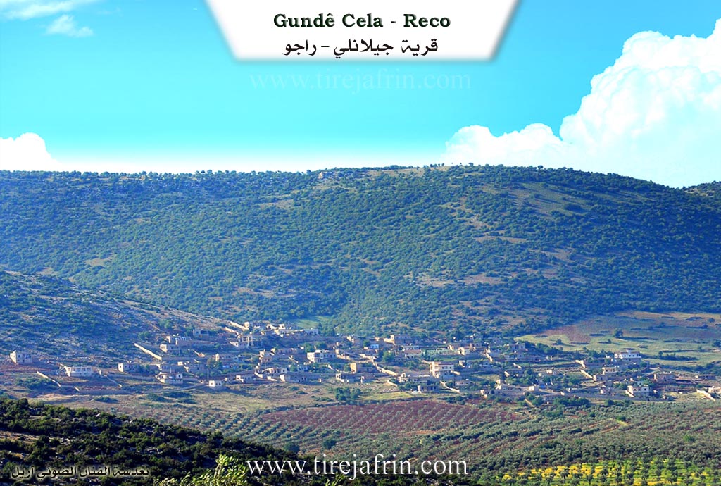
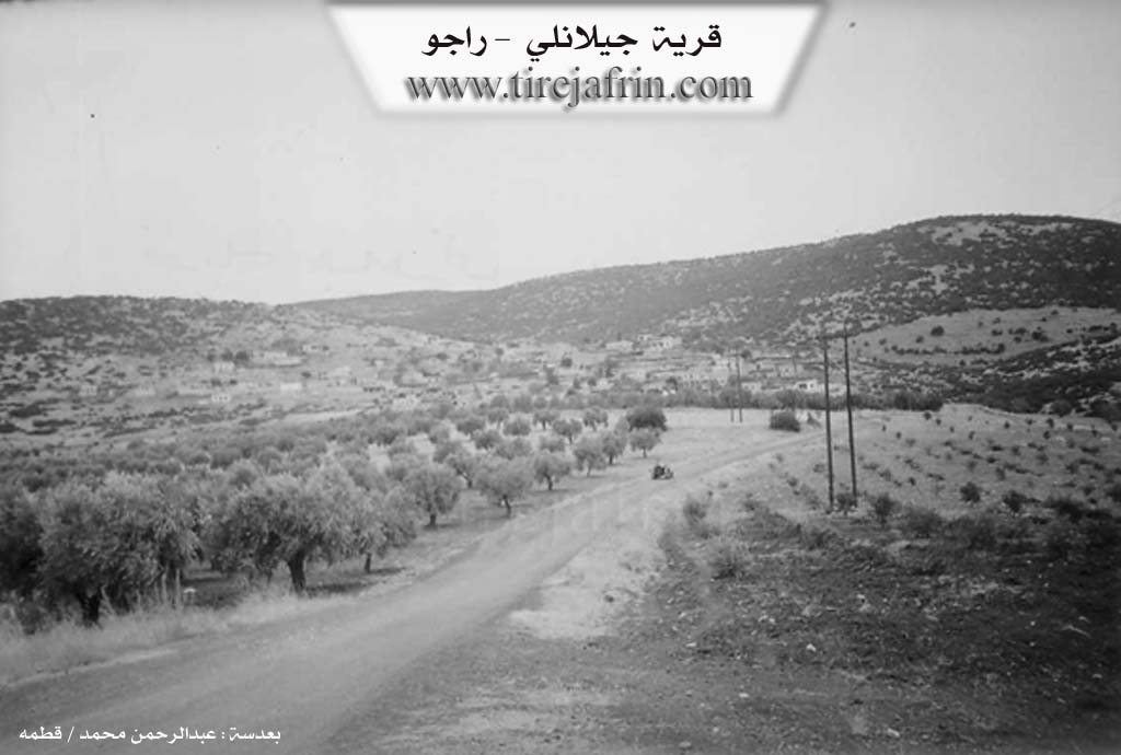
The following is stated in the book عفرين .... نهرها وروابيها الخضراء Efrîn... Her River and Her Green Hills: Cîlanlî is a village in Çiyayê Kurmênc following the Reco district, Efrîn region, Heleb governorate. It is a small village located in the northern part of the mentioned mountain on a high limestone slope, overlooking agricultural lands with alluvial soil to its southeast. It is 15 km away from the town of Reco towards the northeast.
It is bordered to the north by a high mountain range called Qere Bêl and the villages of Kawenda and Şêx Mihemedlî; to the south by a slope and an agricultural plain planted with olive trees, grapevines, and walnuts, the Riya Bilbil-Reco (Bilbil-Reco road), and the village of Elemdar; to the east by a valley, a mountain range, and the village of Soqanlî; and to the west by a rugged mountain range, a valley, and the village of Çeqmeq Kebîr.
The number of its houses is about 50, and its age is approximately 300 years. Note that the old village was located on the southern plain slope of the village, then it moved to its current high location to protect its dwellings from rain and floods. Its dwellings are made of stone and mud with wooden roofs, and there are modern dwellings that have extended towards the southwest. An electricity network and a primary school are available. The village drinks from cisterns dug in front of the houses which collect rainwater, and currently, they have started drilling artesian wells for drinking. It connects to the district center via a dirt road.
The residents work in rain-fed agriculture (olives, vines, grains, legumes, and fruit trees) on an area of 217 hectares. They raise sheep and goats, and a section of them works in the charcoal industry using oak wood.
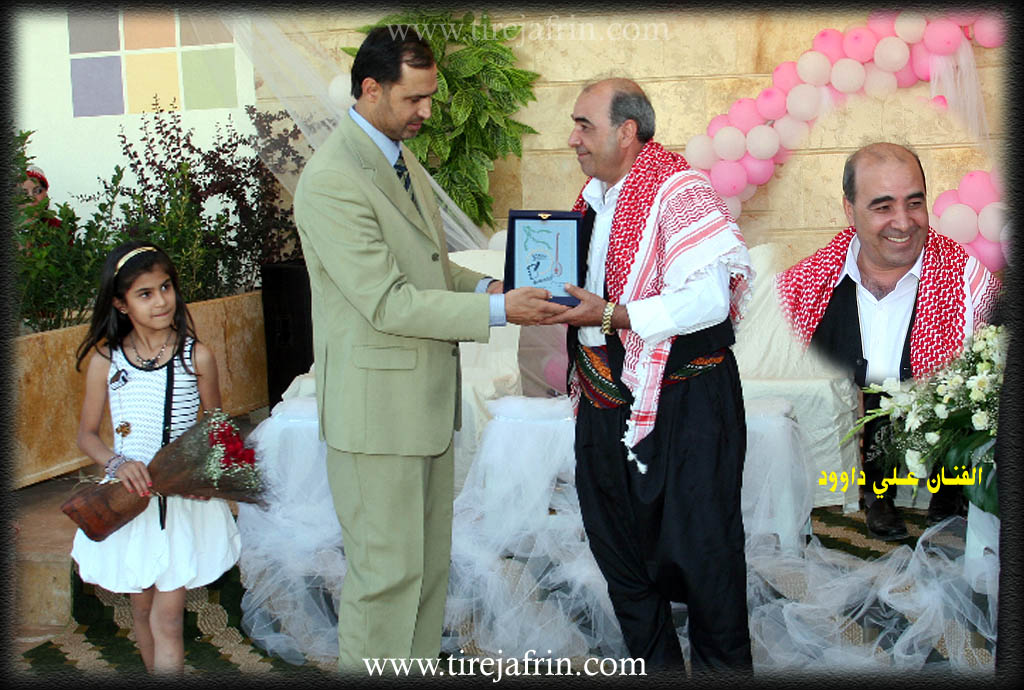
Among the families present in the village are: the Bilê family, the Miste family, the Dadek family, the Zîbe family, and the Kîle family. The village is known for its sense of humor and fun. It is mentioned that the artist Elî Dawûd is a resident of this village.
Village Mukhtar: Şukrî Ehmed Hesen.
Sources of Information:
- Book: جبل الكرد (عفرين) دراسة جغرافية Çiyayê Kurmênc (Efrîn): A Geographical Study by د. محمد عبدو علي Dr. Mihemed Ebdo Elî.
- Book: عفرين .... نهرها وروابيها الخضراء Efrîn... Her River and Her Green Hills by عبدالرحمن محمد Ebdulrehman Mihemed from the village of Qetme.
- Studies of Navenda Tirej Soft / Ebdulrehman Hacî Osman.
- Some residents of the villages.
Preparation and execution: Manager of the Tirej Efrîn site: Ebdulrehman Hacî Osman 20/12/2013.
II. Summary of Cela from Ax û Welat
Source: https://www.youtube.com/watch?v=kmPQZ5qKGxw
Village History and Origins
The village of Cela (also referred to as Jela) is located in the Reco district of the Efrîn region, situated at the foot of Çiyayê Cebelê. According to oral history recounted by village elder Hecî, the village’s origins trace back to two brothers, Cel and Adem, who migrated from Cizîra Botan. They belonged to the Celaliyan tribe. Initially, the group settled near Xulolka at a location known as Sergirekê, about five kilometers east of the current site, where ancient graves still exist. Eventually, the brothers separated; Adem founded the village of Edama, while Cel established Cela, which bears his name.
Social Structure and Families
The inhabitants of Cela are primarily descendants of Cel, specifically through an ancestor named Mist. The village social structure is defined by five principal families (malbat), including Nasirê Celî, Îso, Kêlê, and Hebeşê Hemê. Another lineage mentioned is Moli Dedik. Additionally, a family known as Şanşalo joined the village approximately 150 years ago, integrating into the community through marriage. Some branches, such as Moli Çolîq, eventually moved to the city of Efrîn. The community prides itself on a history of internal peace, with elders claiming that no killings have occurred within the village history due to their strong social bonds, referred to as "Kolkê me."
Landmarks and Sacred Sites
The landscape around Cela is dotted with significant historical and natural features. A notable sacred site is Ziyaretgeha Kulê, located in Geliyê Kulê to the north. The village is also home to mysterious geological formations. One such feature is Taqa Bê (The Wind Arch/Well), a deep chasm that emits warm air in winter and cool air in summer. Local legend holds that ancestors once threw a dog into Taqa Bê, and it emerged alive from a well in the Deşta Cûmê plain, suggesting a deep underground connection. Other water sources include the ancient Bîra Rûmanî (Roman Well) and Bîra Qilavê, a volcanic vent-like opening of unknown depth. To the east lie the ruins of Qişle and Erdê Qoloş, believed to be the site of an ancient town.
Historical Events and Culture
The village has maintained distinct traditions and resilience against external pressures. During the era of the Murîd religious movement, which caused unrest in the Kurdax region, the village head Reşê Hesen and other elders like Bilê Dadik refused to allow the Murîd followers to enter Cela, protecting their community. In the realm of education, before official Kurdish language schools were permitted, children were taught under a specific tree known as Darê Reş. Educator Mamosta Ehmed (known as Ustad Cîlo) recounted teaching generations of children from Cela, Bilîlko, and Çeqmaqê under this tree or in secret, navigating the prohibitions against the Kurdish language. Today, the village is also known for its agriculture, particularly cherry orchards (Kêraz), and preserves its musical heritage through singers like Elî Dawûd.
II. Summary of Cela from Ax û Welat 2
Source: https://www.youtube.com/watch?v=hOiLccYOBK8
Analysis of the Village of Celê
The village of Celê, also referred to as Jela or Celemê, is located in the Reco district of the Efrîn region. It sits 5 kilometers northeast of the town of Reco and 45 kilometers north of Efrîn. The village is situated on the slopes of Çiyayê Terebêlê, overlooking the Deşta Camiye plain to the south.
History and Origins
The village’s history is defined by the migration of the Celaliyan tribe from Cizîra Botan. According to local oral history recounted by the elder Hecî, the founders were two brothers named Cel and Adem. Upon arriving in the region, they initially settled at a location called Sekrekê near Xulalka. Eventually, they separated; Adem founded the neighboring village of Adama, while Cel established Celê, which bears his name. The village was not always in its current location; historically, it was situated at Sergirekê, approximately 5 kilometers to the east, where ancient graves can still be found.
Social Structure
The residents identify as members of the Celaliyan tribe. The social fabric consists of several distinct families. An elder explains that after the time of Cel, an ancestor named Mist established five core lineages. The narrator identifies the four prominent families today as Nasirê Celîl, Îso, Kêlê, and Hebeşê Hemê. Other family names mentioned include Mala Çolîq, Mala Dedikê, and Mala Hemê. A specific group, Did Jindon, is noted to have joined the village later, approximately 105 years ago. While the current population is around 1,200 people, significant migration has occurred, with families such as Mala Çolîq moving to Efrîn and Heleb.
Sacred Sites and Landmarks
The village contains several significant historical and natural landmarks. A sacred site known as Ziyareta Kuhle is located in a deep valley to the north. To the east lies an area of ruins called Qişle and a site called Erdê Qoş, which is believed to be an ancient threshing floor. A large cave known as Şikefta Topelê was historically used for habitation and later for livestock.
Water sources play a major role in the village's geography. There is a "Roman well" (Bîra Rûmanî) and another deep well named Bîra Qilabel, which is described as an ancient volcanic vent of unknown depth. A unique natural feature on the ridge is Taqa Bê (The Wind Vent). Locals describe it as an opening connected to the underground water systems; it emits warm air during the winter and cool air during the summer.
Culture and Reputation
Celê is well-regarded for its agriculture, particularly its cherry orchards. Women in the village, such as the hostess visiting Mala Mehmedê Hisênê Zêbê, are known for making cherry jam (leçera kêraza). The village also has a history of education; Ahmed Dawud, known as Ustad Çîlo, began teaching children in 1951 under a tree known as Darê Reş when the Kurdish language was prohibited in schools. The village maintains a musical tradition as well, preserved by figures like the singer Elî Dawud, who was influenced by legendary dengbêjs like Cemîl Horo.
II. Summary of Cela from Afrin 366
Source: https://www.youtube.com/watch?v=j5yImX8buVY
The documentary explores the agricultural village of Calo, alternatively referred to as Celo, located in the region of Efrînê near the mountainous area of Bilbilê and Çiyayê Bilbilê. The host speaks with the village muxtar, an eighty five year old man named Apo Mihemed who is also affectionately known as Usta Şêxo. Leadership is a longstanding family tradition for Apo Mihemed, as he notes that both his father and his grandfather served as muxtars, with his grandfather holding the position during the era of Firansa.
According to oral history recounted by an elder, the village was established roughly 250 years ago. The foundation legend tells of three brothers, among them Adem and Hecî, who migrated to the region and settled in various locations, ultimately leading to the formation of communities at Cindirêsê, Hemamê, and Cendî. The village of Celo derives its name directly from one of these early founders. However, during the presidency of Hafez El Esad, the Syrian government enforced strict Arabization policies. As a consequence, the historical Kurdish name Celo was officially changed to the Arab name Xezlan.
Today, the village consists of approximately seventy residential courtyards. While the vast majority of its inhabitants are Kurds, the village also hosts two Arab families who live in harmony with the local population. As the host tours the village, he visits an area containing ruined homes that were abandoned fifty years ago, including a courtyard once belonging to a man named Reşîd Şêxo. Nearby, an elder points out a historic stone landmark known as Keberî sûk, an area where villagers traditionally performed the laborious task of pounding and threshing grain by hand before the advent of modern machinery.
Currently, the village is highly celebrated for its fertile agricultural lands and pleasant climate, which an elder favorably compares to Lubnanê. While residents historically cultivated basic grains, they have successfully transitioned to lucrative cash crops over the decades. The local orchards are now abundant with olive trees, vineyards, and apples. The village and the broader Bilbilê district have also become a major hub for cherry cultivation. One local farmer describes a massive initiative that introduced 20,000 cherry trees to the district, sparking agricultural growth that stretches toward Helebê. The villagers also actively cultivate pistachios, specifically the famous variety associated with Helebê.
Throughout the interviews, the elders express a deep sense of Kurdish identity and pride, sending special greetings and blessings to political figures like Barzanî and Kek Mesûd. The documentary closes with footage of the local farmers harvesting crops and managing their fertile fields, before the host announces that his next destination will be the neighboring village of Elemdara.
II. Ax û Walat Book 1
VILLAGE OF CELA
31.5.2016
The village of CELA is affiliated with the Reco district of the Efrîn canton, located 15 km northeast of the city of Reco and 45 km north of the city of Efrîn.
Previously, the village of CELA was in a place called ((Segrekê)), which is about 5 km east of the village, and to this day there are some old graves there.
There were two brothers named ((’Edem and Celî)); ’Edem founded the village of ’Edema, and Celî also settled in the place of the village of Cela and built the village. This means that the name of the village of CELA comes from the name of the village's founder, or (Celî).
The history of the village's founding is not known, but it is clear that this is an ancient village.
The village of CELA is on the slope of Mount Qere Bêlê and faces the Camiyê plain to the south of the village. To the north are the Geliyê Kulê, where the Kulê shrine is located, and the village of Bilêlko. To the east are Erdê Qişlê and the villages of Xilalka and Cirqa. To the south are Mount Bilêl and the villages of Elemdara and Çeqmaqa biçûk. And to the west are the village of Çeqmaqa Mezin and Mount Keleşk.
There is an old well to the south of the village, and the villages of Cela and Bilêlko used to get their drinking water from it, and shepherds watered their flocks at it. In the Camiyê plain, which is to the south of the village, there are many water wells. In the past, there was a mill in that area, and water is still there. The people of the villages of Cela, Çeqmaqa, Çençeliya, ’Elemdara, Kêla, and Huscemala get water from there with tractors.
There are 2 caves in the village; one of them is very wide and large and is known by the name (Şikefta Topel). In the past, the people of the village used it for habitation, then it was used for sheep, but now it is empty.
The well of (Qila Bê) is located to the west of the village. It is said that it is a very deep extinct volcanic vent, and its depth is not known.
An ancient site named (Erdê Qûç) is to the east of the village, and it appears that it was the site of an ancient town in past eras.
The mountain that embraces the village is made of blue stones, which are solid stones and are very good and suitable for construction.
The village of Cela has become modern, and almost no old houses remain. Most of the houses in the village are modern and have been built with advanced engineering.
There are 4 families in the village:
The family of Nasir Celî, Îso, Kêlê, and the family of Hebeşê Hemê. The Celî family, who are known as the founders of the village, are not from the CELALIYA tribe of Memê Alan.
About 80 houses and nearly 1200 people live in the village. Also, about 250 people have settled in the city of Efrîn and live there.
Most of the villagers make their living from agriculture, and the cultivation of olive groves and vineyards is paramount, along with fruit trees like cherries, apricots, almonds, and other trees.
Some families own livestock such as sheep and goats and sell their products in the city of Reco.
More than 10 people work in the institutions and bodies of the Autonomous Administration in Reco. About 15 people also work in various factories in Reco. There is also a restaurant in Meydankê and event halls for the village people, and a good number of people work there. There is a stone quarry, and many various shops belonging to the village people in Efrîn, and their owners and workers make their living from them.
There are 6 martyrs from the village who have given their lives in various times for the freedom and honor of the Kurdish people:
Ş. Kendal, Xebat, Rênas, Îbo, Kerem, and Ş. Serbest Efrînî.
One of the famous people of the village of Cela is the folk singer: ((ELÎ DAWÛD)), who has played a great role in the field of preserving and promoting the Kurdish art and singing of the region, and has created many songs and melodies, and has participated in many national, revolutionary, and social events. Therefore, this village is generally a leader of dance, meaning it loves singing and dancing.
Teacher ((EHMED DEHDO)), known as (Mamoste Çîlo), is one of the first teachers or intellectuals of the Efrîn canton. Along with his early colleagues (Teacher Heyder, Xelîl Ehmed, Fethî Bedrî, and Ezîz Gedro), he taught in the village and cities of Efrîn. Before the school opened in the village, teacher Ehmed would voluntarily gather the village children in homes and sometimes under the Black Tree and at Serî Benê, teaching them and instructing them in reading. It is worth mentioning that he is one of the founders of (EL PARTÎ), meaning the first Kurdish party in Rojava, which was founded in 1947.
The village has protected itself for a long time, and there are no significant problems in the village; that is, the problems that arise are quickly resolved by the Commune. From the beginning, it has protected itself from the rule of aghas and the attacks of gangs and has shown unparalleled resistance.
Many attacks from the Mirûdan occurred on the village, but the villagers rejected and broke those attacks.
Transcriptions and Subtitles
| Source | Video | Subtitles | Transcript |
|---|---|---|---|
| Afrin 366 1 | Watch Video | Download SRT | View Transcript |
| Ax û Welat 1 | Watch Video | Not Available | View Transcript |
| Ax û Welat 2 | Watch Video | Download SRT | View Transcript |
Foundation/Origin Information of Cela
The old village was located on the southern plain slope, then moved to its current high location to protect dwellings from rain and floods.
Source: TirejAfrin Site
Possible Village Name Meaning of Cela
The name comes from the Jalali tribe. An Arabizer believed the name meant "gazelle" in Turkish and translated it to "Al-Ghuzlan".
Source: TirejAfrin Site