General Information
Nahiya (Subdistrict)
Şera
Also Known As
Al-Amoud, Dikme Tash, Dikmetaşê, Dîkmedaş, Dîkmedaşê, العمود, ديكمة طاش, ديكمه طاش
Families, Clans, etc.
Ebû Lera, Elî Gorê, Erebê Qaso, Hemzo, Koçera, Mihemed Ûko, Seîd Ûcî, Xelîlê Têwit

Photos
Basic Information about Dîkmedaşê
Source: Tirej Afrin
Etymology: In the Turkish language, Dikme means the column, and Taş or Daş means the stone
Foundation Date/Period: approximately 300 years
Hills: Seqer Têpe
Other Landmarks: El-Cemîliyê
Summaries
I. Summary from TirejAfrin Site (English) of Dîkmedaşê
Source: https://www.tirejafrin.com/site/kura%20afrin%20%20sheran%20-dekmah%20tash.htm
It is stated in the book Çiyayê Kurmênc Efrîn A Geographical Study: Dîkmedaş, Dikme Taş, El-Emûd / 755 inhabitants 9km 690m /:
Dikme: In the Turkish language meaning the column, and Taş, Daş: in Turkish meaning the stone. The Arabic translation of the name is incomplete.
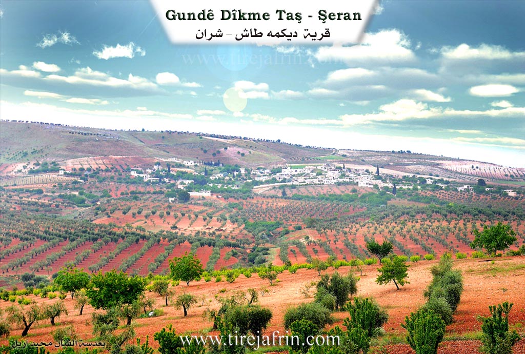
It is a medium village located on the southwestern slope of mount Seqer Têpe. It borders the Turkish border from the north.
It is stated in the book Efrîn... Her River and Her Green Hills: Dikme Taş: A village in Çiyayê Kurmênc following the township of Şeran, district of Efrîn, governorate of Heleb, (731 inhabitants). It is a medium village located in the eastern part of the Kurd massif on the southern slope of the limestone mount Seqer Têpe, which is furrowed by streams descending towards the north. Its soil is clay, pastures are spread over it, and it is 9km away from the town of Şeran towards the northeast. It is bordered by the current borders with Turkey.
It is bordered to the north by a valley planted with olive trees and forest trees and the village of Dêr Sewan and the farm of El-Cemîliyê. To the south by a valley and a slope and a mountain range planted with olive trees, vines, and almonds and the village of Qestel Cindo. To the east by a limestone mountain range and a valley and the Syrian Turkish borders and the village of Yazî Bax. To the west by a slope and a valley planted with olive trees and forest trees and the village of Ereb Wêran.
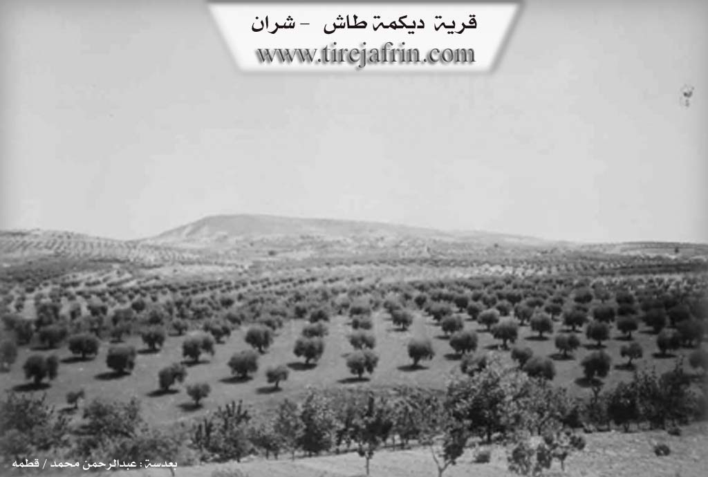
The number of its houses reaches about 75 houses and its age is about 300 years. Its old dwellings are stone and mud with wooden roofs, and the modern ones are cement and stone. An electricity network is available in it, as well as a primary school and an asphalt road up to the center of the village. The residents drink water from artesian wells and water collection in pools. Its inhabitants work in the cultivation of olives, vines, grains, and legumes, and the raising of livestock, sheep, and goats.
Village mukhtar: Munîr Hesen
Sources of Information:
- Book: جبل الكرد (عفرين) دراسة جغرافية Çiyayê Kurmênc (Efrîn): A Geographical Study by د. محمد عبدو علي Dr. Mihemed Ebdo Elî.
- Book: عفرين .... نهرها وروابيها الخضراء Efrîn... Her River and Her Green Hills by عبدالرحمن محمد Ebdulrehman Mihemed from the village of Qetme.
- Studies of Navenda Tirej Soft / Ebdulrehman Hacî Osman.
- Some residents of the villages.
Preparation and execution: Director of the Tirej Efrîn site: Ebdulrehman Hacî Osman 20/12/2013
II. Summary of Dîkmedaşê from Ax û Welat
Source: https://www.youtube.com/watch?v=fNyP0TfOMKw
The village of Dîkmedaşê is located in the Şera district of Efrîn, positioned very close to the northern border. The name of the village has a Turkish origin from the Ottoman period roughly four hundred years ago, meaning seated stone, which refers to a prominent long stone that used to mark the area. Later, under the Baes regime, the village was officially renamed El Amud in Arabic as a direct translation, though the local Kurdish population entirely ignored the new name and continued to use Dîkmedaşê.
Historically, the modern village was not originally built on this exact spot, which once only held ruins. It was founded when families migrated from the village of Qurnê in the Bilbilê district. A historical figure named Reşo reportedly purchased the land from an Ottoman Agha. The foundation of the village rests on four core families: Mihemed Ûko, Seîd Ûcî, Koçera, and Hemzo. In time, they were joined by other families, specifically Erebê Qaso, Elî Gorê, Ebû Lera, and Xelîlê Têwit, growing the settlement to its current size of over one hundred households. Before the creation of the Sykes Picot border, the village enjoyed a highly strategic and open trade route to Kilîs, located just eleven kilometers away. The imposition of the border heavily divided the local geography, stranding relatives and farmlands in Kilîs, Entab, and nearby villages on the other side of the wire, such as Ze'delîn, Salîvanî, and Qereqoyî.
Geographically, Dîkmedaşê is surrounded by several significant landmarks. To the north are Erebwêranê and Geliyê Kawa. To the east lie Seqertepe, also known as Serê Gazê. To the south are Çiyayê Parsê and Qestel Cindo, and to the west are Omera and Geliyê Gurê. The community historically sourced its water from three main wells: the ancient Bîra Jêr, Bîra Gund, and Bîra Kaniyê near the graveyard. The village also contains five ancient caves, which residents use to shelter their livestock.
The villagers sustain themselves mainly through agriculture, cultivating olives, walnuts, and most famously, a wild thyme known as zehter. Because wild zehter originally grew near the dangerous border fences, many residents tragically lost limbs to landmines while harvesting it. To prevent further tragedy, a local elder named Elî Seîd introduced seeds to cultivate the plant safely near their homes. The community is also home to a traditional partridge hunter named Reşîd, as well as an elderly water diviner who uses a divining rod made of Selwa wood to successfully locate underground water for numerous Kurdish and Arab villages across the region, including Alqana, Keferdel, and Çema.
Deeply involved in the regional struggle, Dîkmedaşê has birthed local martyrs such as Harûn Efrîn, Piling, and Mehsûn, with the local commune bearing the name of Piling. Due to its strategic location near Ezaz, the village has faced intense bombardments over the years, famously defending itself alongside the YPG and YPJ forces against brutal attacks from groups like Asîfet El Şemal in late 2013.
II. Ax û Walat Book 1
THE VILLAGE OF DÎKMEDAŞÊ
20/7/2016
The village of Dîkmedaşê is one of the villages of the Şera district, located about 10 km east of the town of Şera and 28 km northeast of the city of Efrînê, and 13 km west of Kilis, and only 500 m south of the border of Northern Kurdistan.
The name of the village Dîkmedaşê is a Turkish name meaning ((upright stone – daş = stone, dîk = upright)). That is, previously a black stone and a white one were standing on top of each other in the village.
174
The foundation of the village's people is from the village of Qurnê, and it is said that a person named Reşo bought the site of the village, where there was previously a ruin, from the Ottomans, and later the name Dîkmedaşê was given to it.
There are many villages around Dîkmedaşê whose names are Turkish, such as Ereb Wêran, Yazibax, Îkîdam; previously they were all affiliated with the Kilis region across the border.
The village of Dîkmedaşê is only 2 km from the city of Ezazê, so the relations and connections of the village people with Ezazê were very strong, and they got all their necessities from there, but after the attacks by gangs on the villages of Efrînê canton, this connection was cut.
There are 4 main families in the village:
The family of Mihmedok, Henan Koçer, Sefero, and the family of Erifê Hemzo. These families are not from one family, but they are all Kurds.
About 125 houses and nearly 800 people are from the village.
The people of the village make their living from agriculture, and like many villages in the canton, the cultivation of olive groves is of primary importance, along with walnut, almond, and grape trees, and the cultivation of za'atar, for which the village is famous. They plant it in their courtyards and enclosures and sell it to merchants.
175
Because za'atar is mostly found on the border, and the farmers' efforts to harvest it, many people from the village have lost their legs due to mine explosions.
Along with them, sumac is also grown to a good extent in the village, and cherry trees have also been cultivated by the villagers in recent times.
About 15 people go to Efrînê daily and work in various factories. 5 people also work as employees in the institutions and bodies of the Autonomous Administration.
To the north of the village of Ereb Wêranê and the Kewa valley, to the east is the Seqerdepe mountain or Serî Gazê which is all rock, the border of Northern Kurdistan and the village of Ze’delîn across the border, to the south is the Parsê mountain and the village of Qestel Cindo, and to the west are the village of Omera and the Gur valley.
It is worth mentioning that all the people of the villages across the border (Ze’delî and Selebiyan) are relatives of the people of Dîkmedaşê, and their relations and connections with each other are still ongoing.
The Lower Well is an ancient well to the west of the village, and the people get their drinking water from it. The Village Well is to the north of the village, but due to the abundance of new wells, its water has decreased. The Spring Well is near the village's shrine, but it is not used.
176
There are 5 ancient caves in the village, which are used as storerooms or as places for sheep and livestock.
There is a primary school, an olive press, and a mosque in the village.
There are 3 martyrs from the village, and their pictures adorn the village:
Martyr Haron Efrîn, Piling, and Martyr Mehsûn. The village commune has been named Ş. Piling.
Some of the notable people in the village are:
Mihemed Dawûd: works as a prosecutor in the People's Court of the Efînê canton.
Darîn Xezewî: is the co-mayor of the Dêrsiwanê municipality.
Reşîdê Xoce: was one of the village's mullahs and was known as a teacher. In the villages of Omera and Yazibaxê in the 1955s, he taught students to read and write.
It is worth mentioning that the Turkish state sometimes bombards the village as a show of anger against the people of Rojava.
Because the village is near Ezazê, it faces many attacks from gangs. One of them was in the 10th month of 2013,
177
an attack by the gangs named (Asîfet Eşşemal) came upon the village, and as a result, all the people of the village took up arms and, with unparalleled resistance alongside the YPG and YPJ fighters against those gangs, they broke those attacks, and the gangs fled and were defeated.
Also, in the war of Qestelê in the years 2013, 2014, and 2015, the people of the village, both young and old, joined the resistance war and protected their region and villages.
Transcriptions and Subtitles
| Source | Video | Subtitles | Transcript |
|---|---|---|---|
| Ax û Welat 1 | Watch Video | Download SRT | View Transcript |
Possible Village Name Meaning of Dîkmedaşê
Dikme: in Turkish means the column, and طاش (tash), داش (dash): in Turkish means stone.
Source: TirejAfrin Site