General Information
Nahiya (Subdistrict)
Reco
Also Known As
Dodo, Dodê, ضوضو
Families, Clans, etc.
Mala Hecî Mehemed, Mala Hesûlero, Mehlero, Mela Bêrîqudê, Mela Mehemedê Dado, Teraşleran, Çûçeleran

Photos
Basic Information about Dodo
Source: Tirej Afrin
Etymology: The name Dodo is a proper noun derived from Dawûd, and is a title for a brave, famous, and bold person. It is also the name of a Kurdish tribe found around Mêrdîn.
Foundation Date/Period: Approximately 250 years
Hills: Çiyayê Behîvê, Qerebêl
Wells: Kavinde
Other Landmarks: Meydanlî plain
Summaries
I. Summary from TirejAfrin Site (English) of Dodo
Source: https://www.tirejafrin.com/site/kura%20afrin%20%20%20Reco%20-%20Dodo.htm
It is stated in the book جبل الكرد (عفرين) دراسة جغرافية Çiyayê Kurmênc (Efrîn): A Geographical Study: Gund Dod, Dodo /1723 people - 72 hectares - 13 km - 800 m/:
Dodo: A proper name derived from Dawûd, and a title for a brave, famous, and bold human /Mukriyanî Dictionary/. It is also the name of a Kurdish tribe found around Mêrdîn. As for Khowrî Bersûm, he says that it is from "the mischievous or the unbalanced" in Aramaic, but we believe this is far from the truth. It is one of the small Meydaniyan villages.
It is stated in the book عفرين .... نهرها وروابيها الخضراء Efrîn... Her River and Her Green Hills:
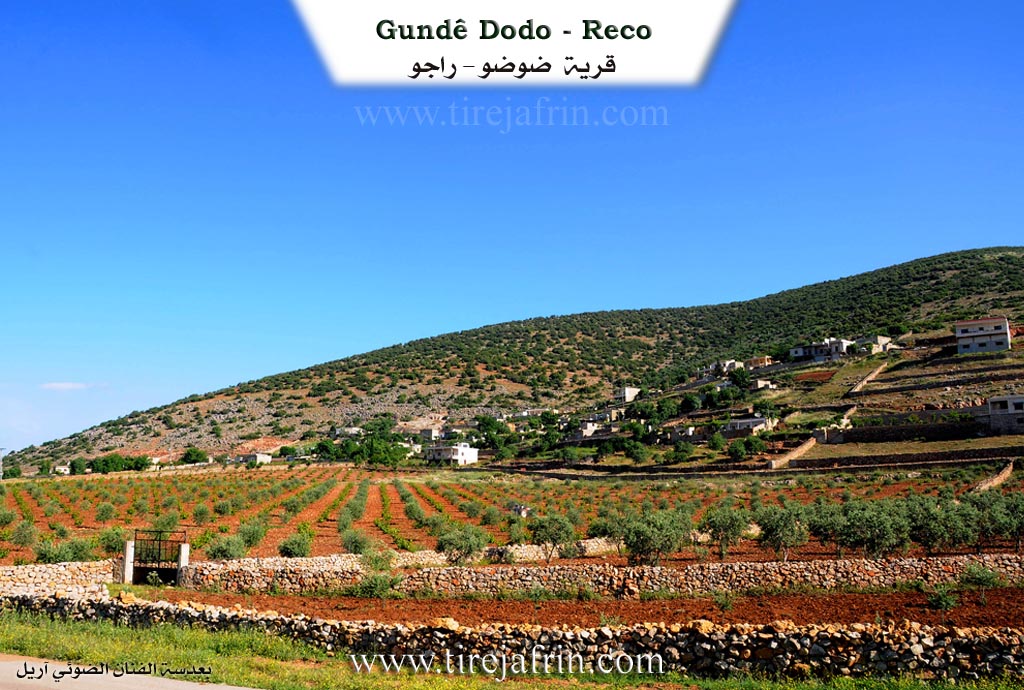
Dodo: A village in Çiyayê Kurmênc following the Reco district, Efrîn region, Heleb governorate. It is a small village located in the northern part of Çiyayê Kurmênc on the southern slope of a limestone height, and it overlooks the alluvial Meydanlî plain to the south. It is 23 km away from the town of Reco towards the northeast.
It is bordered to the north by a high mountain range called Çiyayê Behîvê and the village of Benderlik; to the south by a fertile plain, the mountain range of Qerebêl, and the village of Solaqlî; to the east at a distance of 1 km by the village of Kavinde; and to the west by Valîklî, Şêx Mihemedlî, and Semalk Reco.
The number of its houses reaches about 25 houses and its age is about 250 years. Its old dwellings are stone and mud with flat wooden roofs, while the modern ones are cement and have spread towards the south. An electricity network is available, as well as a water network from the well of Kavinde. It connects to the district center via an asphalted road. The residents work in rain-fed agriculture (olives, vines, pistachios) on an area amounting to 72 hectares, and in raising sheep and goats. It is a mountainous village where oak trees abound; it is unsuitable for general agriculture and is poor. It is one of the Meydaniyan villages.
Village Mukhtar: Husên Mihemed Dawûd
Sources of Information:
- Book: جبل الكرد (عفرين) دراسة جغرافية Çiyayê Kurmênc (Efrîn): A Geographical Study by د. محمد عبدو علي Dr. Mihemed Ebdo Elî.
- Book: عفرين .... نهرها وروابيها الخضراء Efrîn... Her River and Her Green Hills by عبدالرحمن محمد Ebdulrehman Mihemed from the village of Qetme.
- Studies of Navenda Tirej Soft / Ebdulrehman Hacî Osman.
- Some residents of the villages.
Preparation and Execution: Manager of Tirej Efrîn site: Ebdulrehman Hacî Osman 20/12/2013
II. Summary of Dodo from Ax û Welat
Source: https://www.youtube.com/watch?v=eg5Mlq-B-Ks
The provided transcript focuses primarily on the current livelihood and environmental conditions of the village of Qerqozax, rather than its ancient history or tribal composition. The narrative captures a specific moment in time—a harsh winter day—and centers on an interview with a local resident named Raşîd, who works as a fisherman.
The village is situated near a significant body of water which serves as a primary economic resource. According to Raşîd, he is one of only two people from Qerqozax who fish permanently, although people from surrounding villages and the city of Efrîn travel there seasonally, particularly in spring and summer, to fish. The environment is described as unusually cold; Raşîd notes that while snow is common in the highlands (zozan), it has not snowed in this specific location for thirty-eight years, marking this winter as exceptionally severe.
The waters around Qerqozax are home to several specific types of fish, identified by Raşîd as Bûrî, Kerb, Karsîn, and Beraq. He recounts that the biodiversity of the water was formerly much richer, but changes in the water conditions have caused many species to disappear, leaving only four or five varieties. The economy of this trade is local and direct; buyers call or travel from Efrîn to purchase the catch. Prices are set by size, with small fish selling for 500 and large fish for 1000. Raşîd expresses a strong sense of stewardship over the water, criticizing unsustainable fishing practices by outsiders who use nets that waste small or damaged fish. He emphasizes that he and others have been trying to protect the area for several years to ensure the fish population does not deplete further.
Toward the end of the transcript, a narrator provides a crucial geographical distinction regarding the village's identity. There are, in fact, two villages sharing the name. The first is Qerqozaxa Biçûk (Little Qerqozax), which is distinctly known by the alternative name Derwêş. The second is Qerqozaxa Mezin (Big Qerqozax). This indicates a settlement pattern likely born from expansion or administrative division, though the transcript cuts off before detailing the specific founding dates or the tribal origins of the families living in either section.
II. Summary of Dodo from Ax û Welat 2
Source: https://www.youtube.com/watch?v=pIVOzlkRzYQ
Dûdê is a village situated in the Meydana region of the Raco district in the Efrîn canton. The name of the village derives from the word dudu or duduya, meaning the second. This name was given because it is the second settlement encountered when entering the plain from either the east or the west. The village is part of a cluster of seven related villages scattered across the local plain.
The history of Dûdê connects deeply to ancient times. Just south of the village lie the ruins of Bajarê Şeqîf, an ancient city located in an area known as Mehdiyê, which locals associate with the Romans. An elder named Reşîdê Ehmed recounts how ancient inhabitants communicated across the landscape using a system of horns from elevated observation points like Banê Cewşê, Karzin, Keleha, Banî Birkê, and Sûrê. These signals could relay messages over long distances to places as far as Lêçê and Axdapê. In more recent centuries, the modern village was formed when people moved east into the valley of Ecer. The establishment of national borders split the community, leaving some relatives in villages like Dîlo on the opposite side of the border. The village also faced violence from French military forces around the year 1937, after a local man named Hisên Nasir, also known as Kêl Heso, killed three French militiamen, prompting French airplanes to bombard the village.
The social fabric of Dûdê began with a single lineage. The first family to settle the area was the family of Mela Mehemedê Dado, also referred to as Mihemedê Dudê. This founding family consisted of four brothers who eventually formed distinct branches, including the Çûçeleran, Teraşleran, and Mehlero families. Over time, other families arrived and integrated into the village community. These included the Mela Bêrîqudê family who came from the west, the Mala Hecî Mehemed family, and the Mala Hesûlero family who arrived from the neighboring village of Gawanda. Due to economic and political difficulties over the decades, a large portion of the original population has emigrated to Swîsre, Almanya, and Holenda, as well as regional cities like Heleb and Meydan Ekbez.
The remaining residents maintain a deep connection to their land through agriculture and traditional crafts. They cultivate olive groves, vineyards, and pistachio trees. The women of Dûdê are renowned for making traditional grape products, including a grape syrup known as dims, and sweets like qirmê and sunciq, which are prepared by stringing walnuts and coating them in thickened grape syrup. For their spiritual needs, villagers visit Ziyaretgeha Şêx Mûs in the south to pray for healing and the fulfillment of wishes. The landscape is framed by prominent natural features such as Çiyayê Bîvê to the north and Çiyayê Qerebelê and Çiyayê Reş bordering the expansive Deşta Meydanekbasê in the south. The village honors its fallen by naming the local commune after Şehîd Demhat, reflecting the enduring resilience of the community.
II. Ax û Walat Book 1
THE VILLAGE OF DODÊ
4.1.2016
The village of Dodê is one of the Meydana villages in the Reco district of the Efrîn canton. It is located 18 km north of the city of Reco and 53 km north of the city of Efrîn.
The Meydana villages consist of seven villages:
Gewanda, Welîkê, Gazê, Kurê, Miskîtê, Sêmala, and Dodê.
The village of Dodê is located on the Golê plain of Meydana. The name of the village comes from the meaning (dudo) or two, because it is the second village from both the east and west sides among the Meydana villages.
88
There are 6 families in the village of Dodê:
The family of Mihemedê Dedo was the first family to settle in the village, the family of Dedo, Mistî, Heso, Mihler, Hecî Elî, and the family of Qêdir. Most of the families are from the Şêxî tribe.
To the north of the village are the Behîvê mountain and the border of Northern Kurdistan. To the east is the village of Gewanda, to the south is the Meydana plain, above which is the Qerbêl mountain or the Reş mountain. Opposite the village to the south is Şeqîfe, which is like an ancient Roman town, and its traditions are still apparent today. To the west are the village of Welîkê and the Meydana plain.
The Meydana plain has a length of 1000 m by 500 meters, meaning its area is around 500,000 meters. It is all vegetable and fruit orchards and trees and plants.
The AVÊ spring is to the south of the village. It is a spring that was built by the French and its water still exists today. Shepherds water their flocks from it.
The shrine of ((Şêxmûs)) is to the south of the village. People used to visit there for illness and the fulfillment of wishes, and now it has become a burial ground or the village cemetery.
Bîra Xanî is an ancient well to the south of the village.
There are nearly 50 houses and more than 700 people from the village, and many people have settled in the town of Mîdan Ebez and the city of Efrîn.
89
The villagers make their living from agriculture, like most of the region's villages. Primarily, it is the cultivation of olive groves, and secondly, the cultivation of vineyards. Therefore, this area is famous for grapes and their products, such as benî, bastiq, qirme, miwîj, and dims, and they sell these products in the markets of Reco and Efrîn.
Along with grapes and olives, many people plant and care for pistachio trees, and there are also many cherry trees.
Along with agriculture, some families own livestock such as sheep, goats, and cows, and their products like milk, yogurt, cheese, lorik, firo, and strained yogurt are sold in the canton's markets.
Nearly 10 people work in various departments in the institutions and agencies of the Autonomous Administration.
There are 3 martyrs in the village:
Ş. Demhat, Xwînrij, and Ş. Ronahî.
The village commune is named after Ş. Demhat.
During the French rule, Hisên Nasir, also known as Kêl Hiso, disarmed 3 French militiamen in an incident. Later, French soldiers came and bombed the village with airplanes. This was around the year 1937.
The level of education in the village is good, therefore more than 50 people have obtained university degrees in various fields, and many people have also completed vocational and high school education.
90
It is worth noting that the 7 villages of Meydana have become like one village, or like a large and modern town built on a wide plain, and in the future, it will become a developed city.
Transcriptions and Subtitles
| Source | Video | Subtitles | Transcript |
|---|---|---|---|
| Ax û Welat 1 | Watch Video | Download SRT | View Transcript |
| Ax û Welat 2 | Watch Video | Download SRT | View Transcript |
Possible Village Name Meaning of Dodo
Dodo: A proper name from David (داود), and a nickname for a brave, famous and bold person. It is also the name of a Kurdish tribe found around Mardin. Khouri Barsaum says it comes from "the crazy or the disturbed" in Aramaic.
Source: TirejAfrin Site