General Information
Nahiya (Subdistrict)
Bilbilê
Also Known As
عبودان
Families, Clans, etc.
Mele 'Urraş, Mele Kûtê, Mele Xayû, Qasimler, Şêxûrzê

Photos
Basic Information about Ebûdanê
Source: Afrin 366
Etymology: Named after the spring Kaniya 'Ebîdanê and the location Tiliya 'Ebîdanê
Foundation Date/Period: Approximately 250 years ago
Springs: Kaniya 'Ebîdanê, Kaniya sar
Hills: Koze, Ber til
Ruins: Gundî kevin
Trees: Darê Bilbilê
Wells: Bîra 'Ecerkûl
Other Landmarks: Nebî Hûrî, Me'emelê çîmente
Summaries
I. Summary from TirejAfrin Site (English) of Ebûdanê
Source: https://www.tirejafrin.com/site/kura%20afrin%20%20%20bilbile%20-%20obudan.htm
Based on the book جبل الكرد (عفرين) دراسة جغرافية Çiyayê Kurmênc (Efrîn): A Geographical Study: Ebdan / 595 inhabitants / 295 hectares / 12km / 530m.
The origin of the name is from the proper noun "Ebûd", which is a diminutive and term of endearment for the name "Ebdo".
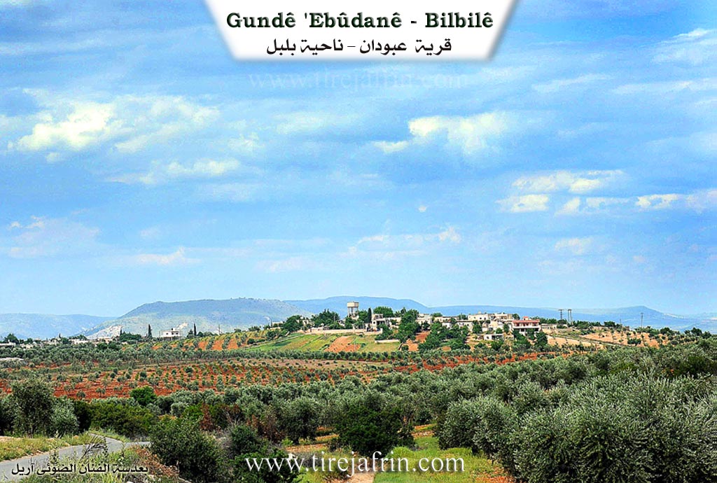
Ebdan is a medium sized village located on the southeastern slope of a plateau. The valley of Geliyê Sor (Red) runs to its south, and the valley of Geliyê Gewr (White) runs to its northeast. Oak forests are spread in its vicinity.
Based on the book عفرين .... نهرها وروابيها الخضراء Efrîn... Her River and Her Green Hills: Ebdan is a village in Çiyayê Kurmênc administratively following the Bilbil district, Efrîn region, Heleb governorate. It is a large village located on a plain and on a rocky flat on the southeastern slope of a limestone plateau that is furrowed on all sides, particularly the valley of Geliyê Sor (Red) to its south, and the valley of Geliyê Gewr (White) to its northeast. Oak forests are spread throughout the area, and its cliffs are rich with trees. Its soil is clay like.
It is located 12km from the town of Bilbil towards the southeast. It is bordered on the north by a wide plain planted with olive trees, the borders of Turkey, and the village of Hay Oxlû. To the south, it is bordered by the valley of Geliyê Sêlê, a high and rugged mountain chain planted with oak trees, and the village of Umer Simo. To the west, a few meters away, is the farm of Heftaro, and the villages of Elî Caro and Şêx Xurz. To the east, it is bordered by the valley of Geliyê Sêlê, a plain, a water passage for Çemê Sabûn (a tributary of the Efrîn river), and the village of Mirsawa.
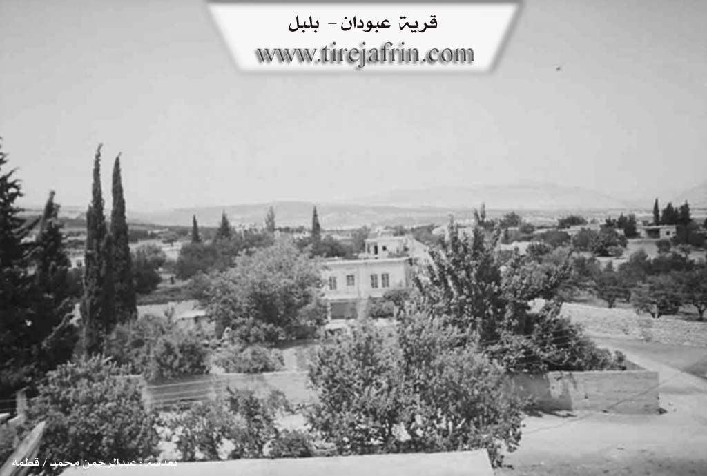
The number of its houses reaches approximately 100 houses, and its age is approximately 300 years. It is a beautiful village situated in a plain, surrounded by fruit bearing olive trees. Its old houses are made of stone and mud with flat wooden roofs, while the modern ones, which are more widespread, are made of cement and extend north and south on both sides of the public road. An electricity network and a primary school are available in the village. The village drinks from a network that draws its water from the Çemê Sabûn project, a tributary of the Efrîn river, and currently from artesian wells dug next to the homes.
Its residents work in the cultivation of olives, grapevines, grains, legumes, and almonds. Agriculture is rainfed on an area of 295 hectares, and irrigated from artesian wells and springs such as Kaniya Ebdan located in the east of the village. The road from it to the town of Bilbil and neighboring villages is paved. The farm of Mezra Heftaro, located a few meters to the western side of the village, administratively belongs to it.
Village Mukhtar: Ebdullah Ibrahîm
Sources of Information:
- Book: جبل الكرد (عفرين) دراسة جغرافية Çiyayê Kurmênc (Efrîn): A Geographical Study by د. محمد عبدو علي Dr. Mihemed Ebdo Elî.
- Book: عفرين .... نهرها وروابيها الخضراء Efrîn... Her River and Her Green Hills by عبدالرحمن محمد Ebdulrehman Mihemed from the village of Qetme.
- Studies of Navenda Tirej Soft / Ebdulrehman Hacî Osman.
- Some residents of the villages.
Preparation and Execution: Manager of the Tirej Efrîn website: Ebdulrehman Hacî Osman 20/12/2013
II. Summary of Ebûdanê from Afrin 366
Source: https://www.youtube.com/watch?v=eDVSYrFbWd0
The village of 'Ebîdanê, located in the Efrîn region of northwestern Syria, falls under the administrative district of Bilbil. It is situated approximately 15 kilometers from Bilbil and lies near the historical site of Nebî Hûrî. According to local oral history provided by the elder Xalê Elî, the village was founded roughly 250 years ago. The settlement's name is derived from a local cold spring known as Kaniya 'Ebîdanê and a feature referred to as Tiliya 'Ebîdanê.
The history of 'Ebîdanê involves a shift in location. The original settlement, referred to as Gundî kevin, was situated at a location called Ber til (meaning "in front of the hill"). Over time, residents moved to the current site, which is described as having abundant water resources. This abundance has allowed the villagers to construct private swimming pools and maintain lush gardens, distinguishing the village's current reputation. The modern village comprises approximately 125 households.
The social structure of 'Ebîdanê consists of several distinct families. One of the primary lineages is the Mele 'Urraş family, who migrated to 'Ebîdanê from the villages of 'Eşûnê and Karrê. Other established families include the Qasimler, Mele Kûtê, and Mele Xayû. There is also a presence of the Şêxûrzê family line, with some residents noting that early inhabitants arrived from Şêxûrzê. The village maintains close ties with neighboring settlements such as Heftêr, Marsa, and Zarê. Just across the border, visible from the village, are the lands of the Moxirjix village and a cement factory, Me'emelê çîmente, located in the Kilis region.
Geographically, the village is marked by specific landmarks. A prominent hill known as Koze overlooks the area; it was historically significant, described by the elders as a "muselxane" (likely a slaughterhouse or sacrificial site) that belonged to the villagers before being lost or handed over. In terms of agriculture, the residents cultivate olives, fistiq (pistachios), and sumac. The villagers also rely on specific water sources, such as the Bîra 'Ecerkûl well and the defining Kaniya 'Ebîdanê. Another navigational landmark mentioned is Darê Bilbilê, located on the road toward the district center.
Transcriptions and Subtitles
| Source | Video | Subtitles | Transcript |
|---|---|---|---|
| Afrin 366 1 | Watch Video | Download SRT | View Transcript |